Class of Technical Ascensions
Report
on the first ascent in the Kyrgyz Ala-Too mountains (Western Tien-Shan) of the north wall of the "Free Korea" peak (4740 m), entered in the USSR Alpine Championship in the 1975 season
Team of the Armed Forces of the USSR (SKA KSAVO) July 1975
| I. Popenko Yu.S. | CMS | captain |
|---|---|---|
| 2. Belovol E.V. | CMS | deputy captain |
| 3. Afanasyev V.M. | CMS | participant |
| 4. Kuramshin R.M. | CMS | participant |
| 5. Polnov V.G. | CMS | participant |
Alma-Ata 1975
6. Description of the route passage
August 14, 1975
From the base camp in the Ala-Archa gorge (next to the Ala-Archa alpine camp) — ascent to the Upper Koronskie overnight stays, located opposite the north wall of the "Free Korea" peak. The approach took 6 hours (departure at 13:00, stop at 19:00). The weather, good in the first half of the day, began to deteriorate in the second half. Precipitation fell, but by evening the sky cleared.
July 15
In the morning, snowfall, the Ak-Sai glacier circus is filled with thick fog. By 12:00, the weather improves somewhat, and the double team: V. Polnov – R. Kuramshin starts processing the ice-rock slope.
They made their way through the soggy glacier and then up the snowy slope, with a steepness of 45–50°, to the start of the route — the bergschrund below the rocky island — in 3 hours. V. Polnov goes first. The weather condition changes frequently: snowfall and fog alternate with short clearances. The 4 m high bergschrund is overcome head-on (section 1). Next, a 15-meter slope with a steepness of up to 65° (ice, dusted with a thin layer of snow) is passed, leading to the rocky massif (section 1).
Bypassing it on the left, the movement continues straight up the ice slope of the same steepness, 40 m long, on crampons with step cutting under the rocky wall to the right of the ice-rock gully (section 2).
Due to a sharp deterioration in weather conditions, the route processing was finished for the first day. The return of the double team to the moraine camp took place at 19:00. Out of the 8 hours spent, 3 hours were spent working on the route. The rest of the time was spent on approach and return. Processing was greatly hampered by the freshly fallen snow flowing down the wall in streams, which covered the participants, clogging their goggles and getting under their clothing.
July 16
The morning, sunny and frosty, gave hope for a good day. At 10:00, the double team V. Afanasyev – E. Belovol starts further processing of the ice-rock slope. For 2 hours, using partially preserved tracks from the previous day, despite the snowfall, they make their way along the glacier to the start of the route.
For 1 hour, they pass the previously processed sections of the route 1–2 using the hung ropes. From the last rope's anchoring point under the rocky wall, they traverse sharply to the left along the ice slope with a steepness of 65° and a length of 50 m (section 3, photo 2). The movement is on crampons with step cutting. V. Afanasyev works first. The 50-meter traverse leads under the overhanging rocky wall to the left of the ice-rock gully, under which it continues another 20 m (section 4) along the boundary of rocks and ice towards a short ice gully, resembling a comma in shape.
Climbing is difficult due to the wall's steepness, especially on the last 10 m (section 4). The ice gully (section 4), 10 m long and with a steepness of 70°, is passed with difficult climbing and clearing rocks from ice, leading to a narrow rocky shelf filled with snow and ice, extending 20 m to the left under the overhanging rocks (section 5, photo 3).
Due to a sharp deterioration in weather conditions, the route processing was stopped for the day. The return of the double team to the moraine camp took place at 19:00. Out of the 8 hours spent, 3 hours were spent working on the route. The rest of the time was spent on approach and return. The processing was greatly hampered by the freshly fallen snow flowing down the wall in streams, which covered the participants, clogging their goggles and getting under their clothing.
Due to unfavorable weather conditions, 100 m were processed on this day.
July 17
The morning greeted the team with a light frost and a clear sky. At 8:00, the double team: Yu. Popenko – V. Polnov set out again for processing. On the glacier, the crust is quite firm, so they move easily. It took 1 hour to approach the bergschrund (start of the route). For an hour and a half, they passed the sections of the ice-rock slope processed over the past two days.
From the place where the last rope was anchored at the end of the rocky shelf, the ascent begins straight up 3 m along a sheer wall using ladders (section 6, photo 3). Then, 2 m of movement goes left-up along rocks of medium difficulty, with a steepness of 60°, covered in snow, leading to a horizontal narrow rocky shelf 5 m long with an overhanging rock at the end. Under the overhanging rock, one has to crawl on all fours (section 6). From the narrow shelf, a wide step transition is made to a wider (1 m) shelf, which ends in a niche convenient for organizing an insurance point (section 6). The niche is the beginning of an internal corner (section 7), formed together with a stepwise rock face of slab-like structure, along which the movement was previously directed towards another wall of the same structure, covered with a thin crust of ice after yesterday's snowfall.
Along the internal corner, with a steepness of 80–85° and a length of 35 m, with an irregular configuration of the right wall and a smooth left one, the movement goes vertically upwards with difficult climbing, sometimes entering deep into the corner, sometimes being pushed out of it and moving to the rocky wall after chipping off the ice crust. The corner leads to a rocky shelf of stepwise structure, composed of large rocky blocks. From the shelf, the path goes along the left side of a sheer smooth rocky wall, 10 m long, overhanging in the upper part (section 8, photo 4). The wall has good cracks and is passed using ladders. Above the wall, a slope begins, with a steepness of about 60°, covered with a layer of ice and snow with rocks protruding from it (section 8). When passing the slope, one has to clear the rocks from ice and snow to use them as support points. After 15 m, the slope abuts a steep smoothed wall, in the left part of which an ice river has made its way (section 8).
Traversing left along the smoothed wall, crossing the ice river 5 m wide, with step cutting, they exit onto an inclined shelf 10 m long, moving along which goes left-up from the outside along protruding rocks (section 8). Crossing the shelf at its left end (section 9), they exit onto an ice slope with a steepness of about 60°, covered with a layer of freshly fallen snow with individual large rocks protruding (section 9). Along the slope, the movement goes straight up under the central part of the wall, to the left of the ice-rock ridge, turning into a purely rocky one before joining the central wall. The length of the path passed along the left end of the inclined shelf and slope is 35 m. At this point, the processing on the third day ends at 19:30. There are 20 m left to the start of the central wall.
The weather throughout the day was favorable, making the third day of processing the most productive. The double team descended to the moraine camp already in the dark, at 21:30.
July 18
Bad weather again. Snow grains fall with short breaks, fog filled the gorge. Visibility is zero. For a moment, a sunbeam breaks through the fog, and again snowfall. The ascent, which was supposed to take place today, is postponed. The wall, of course, is again covered with an ice crust, which will start to shed when the weather clears; although the ice rain does not pose a danger, walking under it is unpleasant.
Time passes slowly. The day is over. We go to sleep hoping for an improvement in the weather and the possibility of going to the wall.
July 19
The morning is frosty — a favorable sign. We dismantle the moraine camp at 7:00. In good pace on firm crust, following barely noticeable tracks in the snow, we pass the glacier and snowy slope to the bergschrund. At 9:00, the first participant begins moving along the hung ropes.
The first double team: V. Afanasyev – R. Kuramshin, with the first, V. Afanasyev, going without a backpack, reaches the supposed bivouac site No. 1 at 13:00, having passed the remaining 20-meter section of the ice-rock slope with a steepness of 65°, with a rocky wall of stepwise structure in the upper part (section 10).
On the same day, 25 m of the central part of the wall was processed straight up from bivouac site No. 1 (section 11). Section 11 starts with a 4-meter rocky wall with a steepness of 80°, which then turns into a wide chimney of the same steepness, 17 m long, filled with ice. Climbing is very difficult, requiring clearing holds from ice. The exit from the chimney in the upper part is made to the right along a sheer smooth 2-meter wall without holds, having several narrow shallow cracks, using ladders (section 11). The wall ends with a narrow shelf, from which 2 m along rocks of medium difficulty, with a steepness of 65°, lead under a rocky slab.
At this point, the rope is anchored, and at 15:00, V. Afanasyev begins descending to bivouac site No. 1. By 19:00, the whole group has gathered here and energetically starts arranging a seated bivouac.
It is impossible to accommodate all participants in one place. For three people, a tent was hung, and two others were placed on separate ledges 1 m below: one in a Zdarsky tent, the other in a cloak-cape.
The weather throughout the day was good, cloudless, and did not create additional inconvenience.
July 20
In the morning, the first group, R. Kuramshin – V. Afanasyev, sets out from bivouac No. 1 at 8:45. A control tour is left on bivouac No. 1. They pass the section 11 processed the day before, and then the path goes 2 m to the right along a short shelf and up along a stone slab, with a steepness of 70°, exiting onto a 20-meter smooth sheer rocky wall with a limited number of holds and a complete absence of cracks (section 12, photo 7). Climbing is very difficult, on friction, in climbing shoes.
Before starting the movement along this section, the first had to decide whether to climb it or use ladders with piton technique. Having experience, the correct choice was made in favor of free climbing in climbing shoes, which successfully passed this section of the route.
The passage of the upper 5-meter segment of the wall is carried out to the right along a narrow chimney formed by the wall and a large slab. For insurance, one piton was hammered into the lower part of the wall. From the chimney, they exit onto rocks of stepwise structure, with a steepness of 70°, covered in snow and partially icy, along which the movement goes to the right and up. 3 m later, a 2-meter sheer rocky wall is overcome, leading to rocks of medium difficulty, representing slab-like structures detached from the main wall. The steepness of these rocks is 70°, and their length is 10 m. They are overcome from left to right and up at an angle of 60° to the insurance point (section 12).
Along a narrow snowy corridor bounded on the inside by a sheer central wall and on the outside by a stone block, the movement goes in a traverse to the right for 3 m. Then the block ends, and the corridor turns into a steeply inclined shelf, along which a 3-meter traverse leads under a 15-meter vertical rocky wall cut from top to bottom by a shallow groove (section 13, photo 5). The wall ends in an inclined rocky-ice slope 4 m wide, which practically crosses the entire wall like a white stripe.
Above the slope, the path goes along an internal corner of triangular section, with a steepness of 75–80° and a length of 15 m, with heavily destroyed rocks (section 13, photo 5). The lower part of the internal corner is divided by a large rocky protrusion into two branches, which merge into one above the protrusion. A landmark for determining the location of the internal corner is a large rocky mass protruding from the wall (photo 5), relative to which the internal corner is located on the left. In the upper part, the internal corner turns left and expands somewhat; its steepness increases to 90°, and after 7 m, it abuts a 1-meter rocky cornice with good holds (section 14, photo 5). At the turn of the internal corner, there is a shelf 0.5 × 1 m, convenient for organizing an insurance point. 7 m in the upper part of the internal corner and the 1-meter cornice are passed by R. Kuramshin with very difficult climbing in climbing shoes.
After the cornice, the path goes first along a rocky slab with a steepness of 80° and a length of 15 m, with a small number of holds and cracks (photo 7), and then 15 m along the left edge of the ice gully with the same steepness, left-up along the boundary of smoothed rocks and ice (section 14). On the left, a rocky slab breaks off with a sheer drop, and on the right, there is an ice gully.
At 19:00, the double team R. Kuramshin – V. Afanasyev finishes work on the route and begins descending down to the bivouac site.
While the first double team was passing the sections of the route above the 4-meter rocky-ice slope, the other participants pulled up the backpacks to the base of the internal corner (a total of 87 m) and traversed 15 m along a narrow shelf under the overhanging rock to a place where this shelf was about 1 m wide.
This section is not given in the table of main characteristics of the ascent. During its passage, 3 rocky pitons were hammered in. Backpacks were transferred to the shelf and back via a cable car on a carabiner (photo 13b).
From above, the shelf is protected from falling pieces of ice by a rocky cornice. On this shelf, using snow bricks, a fairly comfortable platform for a seated bivouac No. 2 was made (photo 11). It took about 2 hours to equip the platform. The sky, cloudless throughout the day, was covered with clouds at 20:00, and snowfall began. But by this time, the tent was stretched, and all participants, including the leading double team, which descended by 20:00, settled in it, sitting. By night, the snowfall stopped, the fog disappeared, and the sky cleared.
The double team R. Kuramshin – V. Afanasyev passed 116 m of new path during the day, including 89 m of complex sections; 54 m were processed upwards from the level of bivouac No. 2.
July 21
Today, the double team E. Belovol – Yu. Popenko works ahead, setting out on the route at 9:00. Having traversed back the path from bivouac No. 2 to the hung ropes, the double team reached the point of their last anchoring at the top by 10:00 and began working on the route. The movement continues for 10 m along the left edge of the ice gully, the steepness of which increases to 85° (section 15), and then moves to a rocky wall 20 m long with the same steepness (holds and cracks are filled with ice), leaving the ice gully on the right (section 15). This wall continues another 10 m and leads to a rocky wall of slab-like structure, into which the ice gully also abuts, and which is intersected in the lower part by a belt of strongly fractured rocks about 2 m wide (photo 8). First, along a 10-meter rocky wall with a steepness of 85° (section 16), the movement goes steeply to the right and up, and then along the belt of fractured sheer rocks, traversing to the right and up for 20 m (section 16, photo 8), exiting onto a narrow shelf under a sheer wall with "live" stone slabs, some of which are quite large. The traverse continues along the shelf to the right for another 3 m to a point where insurance can be organized. From the insurance point, the ascent goes vertically up along a sheer wall with "live" slabs (section 17, photos 8–10), which emit a dull sound when struck. Climbing on this section is accompanied by significant psychological and physical stress. One has to be extremely cautious and attentive when choosing holds and cracks. Technical means such as ladders and, in some places, pitons are used for reliable insurance, as hammering pitons into cracks can cause the separation and fall of rocky slabs. Therefore, only 15 m are passed along the wall by the end of the day (section 17). In the upper part, the wall is overhanging with a half-meter cornice, which still needs to be overcome. There is no other path, as on the left, this wall turns into a sheer, completely smooth wall, and on the right, it is covered in ice. The double team's work on the route ends around 19:00, and they begin descending down to bivouac No. 3, for which a place is chosen on the only steeply inclined shelf at this section at the end of the 20-meter wall — on the left (section 15, photos 21–22). Three people sit in a tent suspended in a hammock made of main and auxiliary ropes, and the other two participants are placed on separate ledges below the shelf.
The weather during the day was cloudy, with periodic snowfall, but by evening, the sky cleared. The stars are visible at night.
July 22
Bivouac No. 3 is inconvenient (photo 21), so the double team Yu. Popenko – E. Belovol, which is working on route development again today (Yu. Popenko goes first), sets out late, at 9:20. For 1 hour and 10 minutes, they pass the sections processed the day before, and at 10:30, they continue moving further along the sheer wall (15 m) straight up (section 17a, photos 8, 10). Climbing is very complex due to the reasons described above, using ladders and a platform. For insurance, two pitons are hammered in. After overcoming the half-meter rocky cornice, which ends the second 15-meter segment of the wall, they exit onto the upper part of the wall, having a stepwise structure, with a steepness of 80° and a length of 8 m (section 17a). The wall ends with a narrow shelf. From the shelf up, under the Big Cornice, there extends a steep wall composed of many vertical triangular ribs of different sizes with a limited number of holds and cracks (section 18, photo 10). On the right, this wall forms an overhanging right angle with a massif of red rocks, the walls of which are covered with a thin film of ice, and on the left, it breaks off in a step onto a smooth, also sheer slab. The first 30 m of the wall are vertical (section 18, photo 10) and are passed in climbing shoes exclusively on friction, as the holds and ledges are inclined downwards and smoothed. Above, on the next 30 m, the steepness of the wall decreases to 80°, and the wall turns into a slab also with smoothed holds, covered in ice, leading under the Big Cornice (section 18, photo 12) of red color, through which lies the exit to the counterfort.
Under the Big Cornice, the double team's work on the route ends around 19:00.
The weather throughout the day is excellent; however, as the sun sets, it gets colder on the wall. The double team's descent to bivouac site No. 4 on a shelf 20–30 cm wide took about 40 minutes. The other participants have already pulled the backpacks onto this shelf and are weaving a hammock for a seated bivouac. After dinner, they settle in three places: two in a tent spread on a hammock, one on the same hammock but outside the tent (photos 26–27), and two separately, using platforms.
July 23
The double team sets out in the morning at 8:30. For 1 hour, they pass the sections processed on July 22. From 9:30, the double team V. Polnov – V. Afanasyev begins working on the cornice. V. Polnov goes first, moving to the right and up. From the very beginning, ladders, a platform, and pitons are used.
The relief of the Big Cornice rocks is represented by large steps, as if descending from top to bottom but in an inverted form; the structure of the rocks is large slabs, the use of cracks in which can cause their separation and fall onto the participants below. The Big Cornice has an overhang of about 15 m in the middle, decreasing to 10 m on the right (section 19). Due to the peculiar structure of the relief described above, passing the cornice required great caution and the use of pitons hammered into monolithic rocks between the slabs. On this day, in 9 hours and 30 minutes, only the section of the Big Cornice 35 m long was processed (section 19, photo 12).
At 18:00, V. Polnov anchors the main rope at the end of the passed section and begins descending down to the future bivouac site under the cornice, although there is no definite place for its organization. Each participant, placed like a garland one above the other, arranges an individual bivouac using platforms, ladders, ropes, ice axes along the second 30 m of the wall (section 18, photo 12), leading under the Big Cornice.
Two snowy patches visible from below under the Big Cornice turned out to be snow lying on a smooth slab, which immediately slid off when loaded. The snow on the left on this slab lay like a cornice with a deepening in the form of a trough on the side of the rocky wall. It is not impossible to organize a seated bivouac on this cornice, but the passage to it on the left along the smooth slab is greatly hampered.
Therefore, they settle on the bivouac option described above, which received the ordinal number 5. Backpacks from bivouac No. 4 to bivouac No. 5 were pulled up.
July 23 began with light snowfall, which stopped and resumed again until 14:00, not causing significant inconvenience to the participants, especially the one going first, who was protected from the snowfall by the Big Cornice. In the second half of the day, the snowfall intensified, the summit was shrouded in black rain clouds, and thunderstorm discharges began in the immediate vicinity of the wall. The air and rocks were highly electrified, and all participants, except the first one, who was in a dry place under the Big Cornice, felt the discharges passing through their bodies when touching the wet rocks. The thunderstorm was accompanied by unusually abundant snow grains. By 16:00, the thunderstorm had ceased, the sky cleared of clouds, but the two hours that passed seemed like an eternity. By night, the clouds gathered again and episodically shot snow charges until morning. This was well felt by the participants who spent the night without a tent. Under the Big Cornice, the second control tour was left.
July 24
The ascent was early, but due to bad weather and bivouac conditions, the first double team, Yu. Popenko – E. Belovol, set out on the route only at 9:00. For 1 hour, they passed the section of the Big Cornice processed the day before.
From the rope anchoring point, the movement goes 2 m in a traverse, and then 10 m up along a sheer smooth wall on the left side of a large internal corner to a huge slab overhanging inside the corner, and further 15 m along this slab (section 20, photo 13b). Climbing is very complex. Throughout, a platform and ladders are used. When passing the 10-meter sheer wall, one piton was hammered in for insurance and movement, as there were no cracks in this place. When moving along the huge slab, insurance and artificial support points were organized using paired channels 30 mm thick, as the width of the crack between the monolith wall and the slab reached 50–60 mm, and there were no other cracks on this section (section 20, photo 13b).
The large internal corner with the slab in the upper part on the left side leads to the counterfort. The path goes 5 m along a slab with a steepness of 70° (section 20), and then 10 m along rocks with a steepness of 65°; to the left of the counterfort ridge. The rocks are partially destroyed, covered in snow, with sections of accretion ice. Further, the path goes 30 m along rocks of block structure, with a steepness of 70° (section 21), to the right and up towards the counterfort ridge, and on the last 10 m — along slabs of the same steepness without cracks, covered with accretion ice (section 21). The movement continues in a traverse along a slab covered in ice, with a steepness of 70°; 15 m to the red wall and from it down along the ice-snow slope 5 m onto the counterfort ridge (section 22).
The first participant's exit onto the counterfort ridge took place at 19:30, and the approach of the remaining participants and the pulling up of backpacks were completed by 21:00. On the ridge, bivouac No. 6 is organized by cutting a step for sitting about 1 m wide in the ice that had formed on the rocky slab. A tent is spread on the step, in which four people can sit, and the fifth participant is placed separately in a Zdarsky tent.
July 25
Work on the route begins at 9:00, as usual. The double team E. Belovol – Yu. Popenko goes first.
The movement from bivouac No. 6, where the third control point is left, begins with a 5-meter ascent along an ice-snow slope on a rope hung the day before, followed by a 5-meter traverse to the right along a slab with a steepness of 70°, exiting onto a rocky ridge (section 23).
Having passed over the ridge, the movement continues 35 m to the left of it along an ice gully with a steepness of 85°, with individual rocks protruding from the ice (section 23, photo 33).
The gully continues another 20 m, where its steepness reaches 90° (section 24). Above the ice gully, they turn to the right into a rocky gully of triangular section, with a steepness of 65° and a length of 10 m, partially covered in snow (section 24), which ends on the left with a 10-meter wall with holds covered in snow and ice, having a steepness of 65° (section 24).
Along the left side of the main ridge, the movement goes up 30 m along the boundary of rocks and ice (section 25). A large slab encountered on the way is passed from above, leaning against the rocky wall on the right (section 25). The last 10 m are overcome along a wall of stepwise structure under a smooth slab (section 25). The overall steepness of section 25 is 65–70°. Again, for 5 m, the movement continues along the boundary of rocks and ice, after which they enter an internal corner with a steepness of 90° and a length of 7 m, exiting onto a shelf at its top (section 26, photo 34).
From the shelf, there is a 8-meter traverse along a smooth steep (70°) slab above a characteristic large slab filled with ice, and an exit into the bed of an ice river, along which the movement goes for 20 m along the right edge (in the direction of movement) along the boundary of rocks and ice, simultaneously clearing ice from smoothed rocks protruding (section 26, photo 34). The steepness of the ice river is about 80° (section 26, photo 34). Another 10 m continue moving along the ice river (section 27), after which they exit to the right onto a rocky sheer wall with protrusions, which is traversed — 12 m (section 27), from right to left, followed by an ascent up the wall for 5 m. From the wall, they enter an internal corner 8 m long and with a steepness of 70°, over which a stone block overhangs (section 27), making movement difficult. Then, there is a 2-meter ascent along a rocky wall covered in snow, with a steepness of 65° (section 27), and an approach under the next internal corner. To enter it, a sheer 2-meter rocky wall is overcome.
The internal corner, with a steepness of 65° and a length of 8 m, has protrusions but is filled with ice and snow (section 28). Therefore, when passing through it, laborious work was required to clear them, which complicated the climbing. The internal corner leads to an ice slope with a steepness of 65°, covered with a thick layer of snow (up to 1.5 m in the lower part). Along the slope, 30 m lead to a snowy ridge of the same steepness, and along it, another 30 m approach under a rocky "bald head" (section 28). On the last 5 m of the ridge, the snow cover is absent, and the movement goes along smooth ice with step cutting. On the "bald head," an insurance point is organized. From the "bald head," they traverse left along the edge of rocks breaking off on the left with a sheer drop, 10 m (section 29) to an ice-snow slope with individual rocks protruding in the lower part. Along the ice slope with a steepness of 70° (10 m), they ascend left and exit into a gap in the ice-snow cornices (section 29) onto a snowy ridge leading to the summit of the "Free Korea" peak.
At the exit to the snowy ridge, a convenient bivouac No. 7 was organized on a prepared wide platform, which allowed for setting up a tent and accommodating in it lying down. However, the first participant's exit to this bivouac took place at 20:30, and the rest — already under the moon, at 23:00. This was due to a sharp deterioration in the weather in the second half of the day. From 14:00, snowfall began, a strong cold wind blew, and the approaching fog reduced visibility to 15–20 m. Under these conditions, the group's movement slowed down. Staying on the counterfort for the night was not possible due to the absence of even a remotely suitable platform, and organizing a seated bivouac for the 7th time was not worth it due to the proximity of the ridge. Therefore, it was decided to work until they reached the ridge, considering that the first participant had already exited there, and the other participants could move along the hung ropes.
July 26
Due to the late exit to bivouac No. 7, the ascent was late in the morning. They enjoy the rest. The exit from bivouac No. 7 took place only at 13:30. Along a simple ridge, the entire team ascends to the summit (section 30) of the "Free Korea" peak in half an hour (photo 35), towards which they were heading for 7 days. From the summit, they retrieved a note left by the group from the "Ala-Archa" alpine camp (led by V. Kochetov), which had made an ascent of 6A category of difficulty (appendix 13). At 15:00, they began descending from the summit, first along the ridge in the direction of Ak-Tau peak, and then along the western slope into the Top-Karagay gorge. From the Top-Karagay gorge, they exited into the Ala-Archa gorge, arriving at the base camp by 23:10, where they were warmly welcomed by their colleagues from the training camp.
 Photo 1. Profile of the north wall of the "Free Korea" peak (4740 m).
 Caption: Team of SKA KSAVO
7. Table of main characteristics of the ascent route north wall of "Free Korea" peak
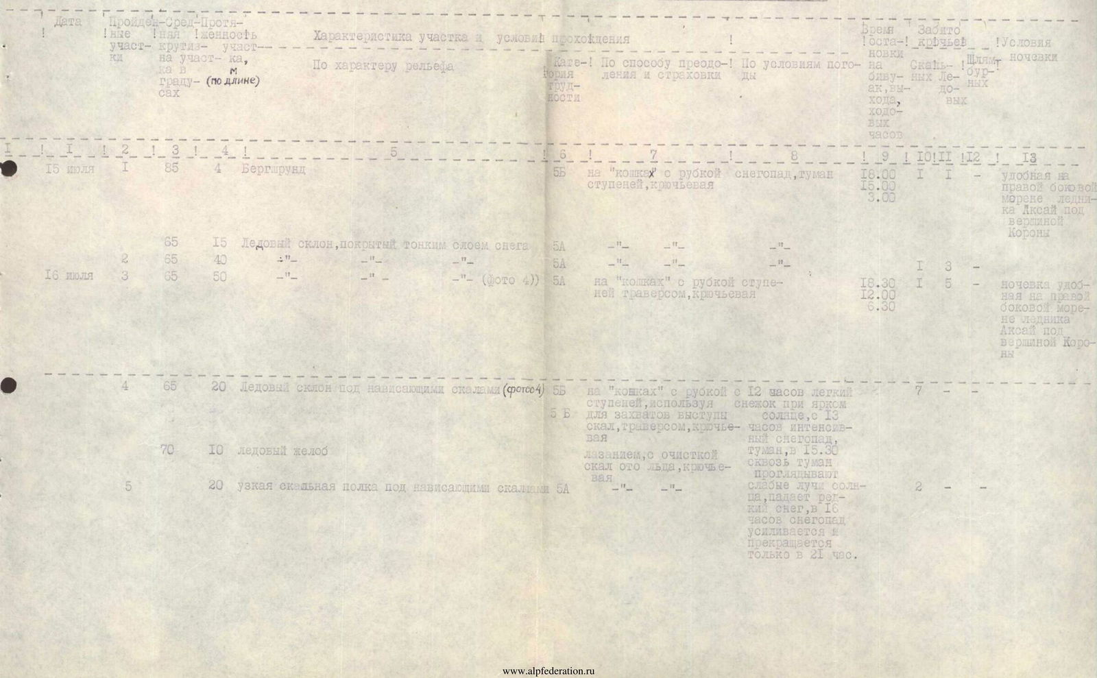
| Date | Section No. | Average steepness in degrees | Section length (by length) in m | Characteristic of the section and climbing conditions | Difficulty category | Method of overcoming and insurance | Weather conditions | Time of exit/stop at bivouac, working hours | Pitons hammered in (Rocky/Pitons) | Bivouac conditions |
|---|---|---|---|---|---|---|---|---|---|---|
| July 15 | 1 | 85 | 4 | Bergschrund | 5B | on "cats" with step cutting, piton insurance | snowfall, fog | 18:00 (exit) | -/- | convenient on the right lateral moraine of the Ak-Sai glacier under the Corona peak |
| 1 | 65 | 15 | Ice slope covered with a thin layer of snow | 5A | -"- | -"- | 15:00 (work) | -/- | -"- | |
| July 15 | 2 | 65 | 40 | Ice slope of the same steepness | 5A | -"- (photo 2) | -"- | 12:00 (work) | -/- | -"- |
| July 16 | 3 | 65 | 50 | Ice slope | 5A | on "cats" with step cutting, traversing, piton insurance | light snowfall with bright sun, from 13:00 intense snowfall, fog, at 15:30 sunbeams appear through the fog, rare snowfall, stops only at 21:00 | 18:30 (work) | 1/5 | overnight stay is convenient on the right lateral moraine of the Ak-Sai glacier under the Corona peak |
| 4 | 65 | 20 | Ice slope under overhanging rocks (photo 2) | 5B | on "cats" with step cutting, using rock outcrops for grips, traversing, piton insurance | -"- | 12:00 (work) | -/- | -"- | |
| 5 | 70 | 10 | Ice gully | 5B | climbing, clearing rocks from ice, piton insurance | -"- | 6:30 (work) | -/- | -"- | |
| July 17 | 6 | 90 | 3 | Rocky wall |