I. Technical class.
- Kirghiz Ala-Too, Ak-Sai gorge.
- Peak Svobodnoy Korei, via North wall, 4740 m.
- Difficulty category — 6B
- Height difference: 795 m, length: 1047 m.
Length of sections with 5–6 difficulty category: 582 m. Average steepness of the route: 66°. Average steepness of the wall section: 75°.
- Pitons driven:
-
rock: 66/7
-
bolt: 18/10*
-
chocks: 73/10
-
ice screws: 21
-
— use of previously driven pitons.
- Climbing hours: 28.5 h, days: 2.
- Overnights:
- 1st — in hammocks
- 2nd — on a ridge platform.
- Leader: Borisov Sergey Viktorovich, Candidate Master of Sports Participants:
- Agafonov Alexander Alexandrovich, Candidate Master of Sports
- Ermachek Yury Vladimirovich, Candidate Master of Sports
- Zadvoryev Yury Vasilievich, Master of Sports
- Pordnov Sergey Borisovich, Candidate Master of Sports
-
Coach: Pordnov Sergey Borisovich, Candidate Master of Sports
-
Route entry: July 2, 1987. Summit: July 4, 1987, return: July 4, 1987.
-
Organization: Sverdlovsk Regional Committee for Physical Culture and Sports.
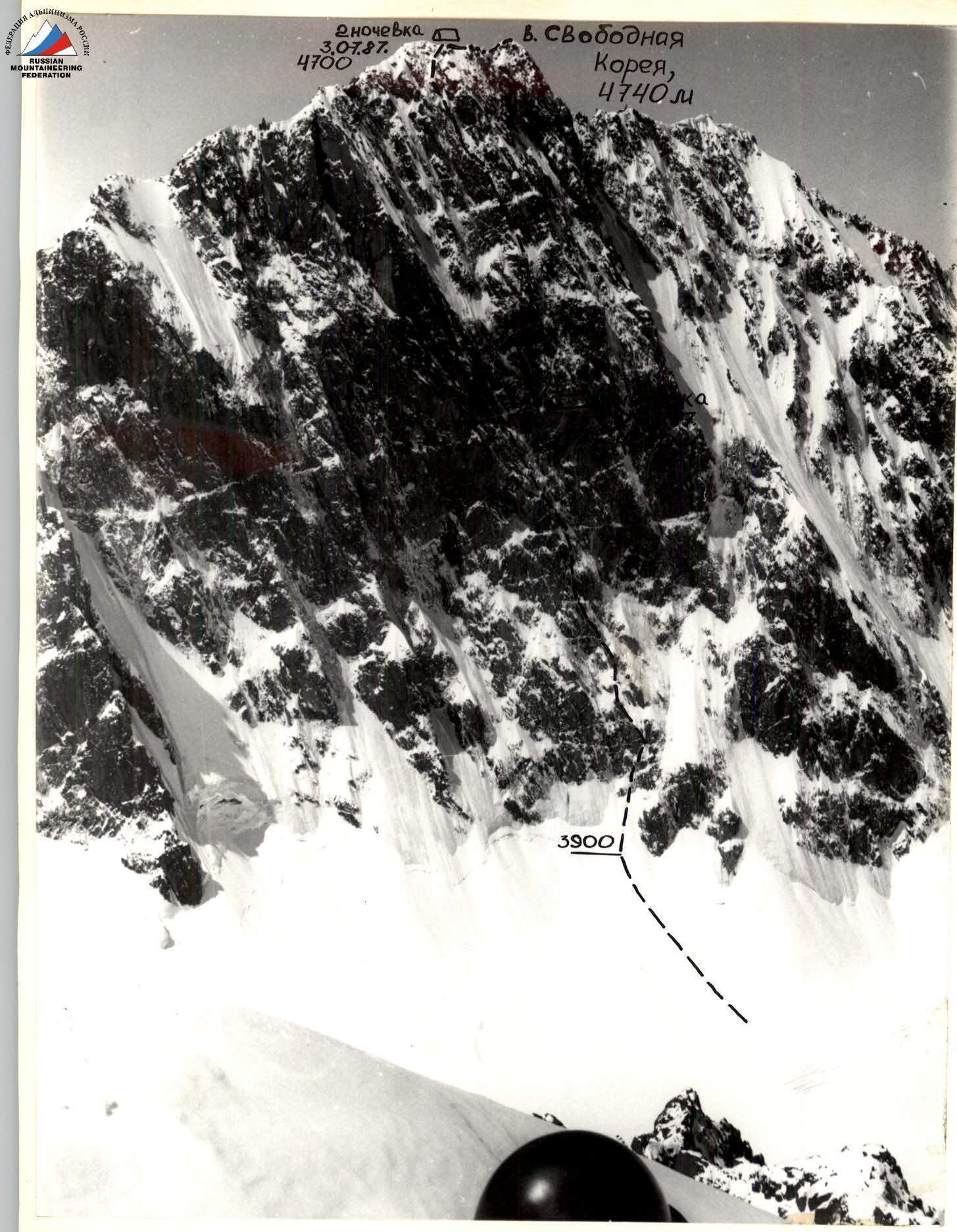
General photo of the summit Camera: Zenit Lens: Jupiter 37A Focal length: 135 mm Distance to object: 1 km Shooting point number on the area diagram: (1) Shooting point height: 4400 m Shooting date: June 25, 1987 Shooting time: 12:00
Tactical actions of the team
The team's exit to the route was preceded by a long period of bad weather, during which up to 75 cm of snow fell (according to the IMC "Alplager"). The tactical plan was drawn up taking into account this factor and the daily bad weather in the second half of the day. Constant low temperatures, severe glaciation of the route, especially the destroyed lower part, contributed to the "cementing" of "live" stones and blocks, which reduced the risk of passage and increased the safety of the route. On the other hand, these factors contributed to an increase in psychological tension for the first participant due to the difficulty of accurately assessing the reliability of footholds and organizing belay points. This somewhat reduced the speed of passage. A large selection of modern equipment and high personal training of participants made it possible to successfully resolve these issues.
The first participant constantly worked in crampons, with ice axes (or ice hammer). Only one rope on the first day was passed in galoshes. The area of the proposed overnight stay was under a waterfall, melting on the "roof" of snow and flowing from a huge cornice to the middle part of the route. Therefore, it was decided to move further under the protection of the cornice (to overnight stay No. 3 of the first ascenders).
The absence of usual bad weather and the made time reserve contributed to the solution of this task. At 19:00, the first one approached the bivouac site. The high pace adopted on the first day was maintained on the second day. This made it possible to reach the ridge by the end of the second day, where the second overnight stay was organized.
The ascent to the summit took place in the morning on the third day. Throughout the entire route, there were no deviations from the tactical plan for organizing the movement of rope teams and their interaction. The first one worked on a double rope (UIAA + simple domestic) with lower belay, the rest climbed using a fixed rope hung by the first one, using jumar, on double belay (fixed rope plus upper or lower belay).
On the first day, Borisov worked ahead, followed by Agafonov (on processing — Agafonov worked first), followed by Zadvoryev, Ermachek, Pordnov. On the second day, Agafonov was in front, followed by Borisov and the trio in the same order. Physical, technical, and psychological preparation allowed the first participant to work throughout the day with a high degree of reliability, and the narrow specialization of team members on this ascent, in addition to reliability, ensured an increase in the group's speed.
Much attention was paid to safety on the route. Severely destroyed rocks, filled with ice, made it difficult to organize belay points and belay stations. Chocks and ice screws were used everywhere. Belay stations were organized from 2–3 blocked points. At key sections of the route, stations were set up for belaying the first participant and for the group's ascent.
As usual, on a short 2–3-day complex technical ascent, the group worked with a long working day (more than 12 hours) without specially allocated rest hours. The difficult terrain greatly slowed down the movement of the first participant and gave the group a chance to rest at the stations. On the ascent, 2 hot meals were organized with individual snacks during the day. This saved a lot of time and allowed the group to gather together only for overnight stays. Overnight stays were organized in backup locations:
- the first — in hammocks on a vertical wall with a narrow shelf, covered from above by a small overhang, using bolt pitons of the first ascenders;
- the second — on the ridge on a good platform.
Good weather in the evening and the absence of signs of bad weather made it possible not to fear a thunderstorm. There were no falls or injuries on the ascent.
4.5 kg of food was taken on the route, calculated as: 500 g per person per day, plus 300 g — reserve. The basis of nutrition was made up of freeze-dried products: meat, cottage cheese, and natural products: lard, honey, dried apricots, prunes, nuts, bakery products — crackers. Nutrition was separate for better assimilation of food. The LIV-52 preparation was used to improve digestion.
Radio communication with the observation group was carried out using R-147 radios every odd hour. A rescue team of 6 people with the necessary supply of equipment and food was located in a hut under the Koronsky glacier throughout the ascent. YUAAscheme Total number of climbing hours — 28.5 h. Number of climbing hours on the second day — 11.5 h. Number of climbing hours on the third day — 1 h.
| Section | Chocks | Rock | Ice | Bolt | Length (m) | Steepness (°) | Difficulty category |
|---|---|---|---|---|---|---|---|
| R30 | 2 | 4 | 2 | – | 120 | 20 | 2 |
| R29 | 3 | 2/3 | – | – | 40 | 40 | 3 |
| R28 | 2 | 2 | 2 | – | 120 | 50 | 5 |
| R27 | 3 | 4 | – | 1* | 40 | 60 | 5 |
| R26 | 2 | 2 | – | – | 10 | 75 | 5 |
| R25 | 1 | – | – | 2* | 30 | 60 | 5 |
| R24 | 4 | 2 | – | – | 20 | 80 | 5 |
| R23 | 2/2 | 1/1 | – | – | 10 | 75 | 5 |
| R22 | 3/2 | 4 | – | 1* | 30 | 90 | 6, 1 |
| R21 | 2 | 3 | – | – | 25 | 110 | 6, 4 |
| R20 | 1/1 | – | – | – | 30 | 70 | 5 |
| R19 | 4/2 | 3/2 | – | – | 30 | 80 | 5 |
| R18 | – | – | – | – | 35 | – | 5, 1 |
| R17 | 7/2 | 2 | – | – | 5 | 75 | 6, 1 |
| R16 | 2 | 4 | 2 | – | 30 | 70 | 5 |
| R15 | 3 | 2/1 | – | – | 10 | 80 | 6, 2 |
| R14 | 2 | 2 | 2 | – | 40 | 70 | 5 |
| R13 | 1 | – | – | 2* | 10 | 65 | 5 |
| R12 | 4 | 2 | – | – | 25 | 70 | 5 |
| R11 | 2/2 | 1/1 | – | – | 100 | – | 6, 2 |
| R10 | 3/2 | 4 | – | 1* | 10 | 75 | 5 |
| R9 | 2 | 3 | – | – | 20 | 75 | 5 |
| R8 | 1/1 | – | – | – | 5 | 70 | 4, 1 |
| R7 | 7/2 | 3/2 | – | – | 35 | 80 | 6, 2 |
| R6 | – | – | 3 | – | 5 | 70 | 4 |
| R5 | 7/2 | 2 | – | – | 20 | 85 | 6, 1 |
| R4 | 3 | – | – | 1* | 20 | 80 | 5 |
| R3 | 6 | 2 | – | – | 40 | 65 | 4 |
| R2 | 5 | 5 | 4 | – | 110 | 60 | 5 |
| R1 | 3 | 2 | 2 | – | 40 | 60 | 4 |
| R0 | – | – | 3 | – | 80 | 50 | 3 |

Description of the route by sections
The entire route can be roughly divided into three sections that differ in complexity.
- The first — a snow-ice slope and simple (4th category of complexity) rocks, up to the I control point.
- The second — the main part of the wall — steep (in the upper part overhanging) rocks, approximately up to section R28.
- The third — the upper part of the wall — ice, snow-covered rocks and the summit ridge.
Section R0 — snow-ice slope, the lower part is climbed simultaneously, when crossing the bergschrund and above to the rocks — piton belay. Section R1 — snow-covered gentle rocks. Section R2 — snow-covered rocks like "sheep's foreheads". Difficulty in driving pitons. In some places, ice exits — piton belay through ice screws. Section R3 — a vaguely expressed wall with good footholds. Snow, ice. Section R4 — a steep wall, above the I control point. Section R5 — an internal corner filled with ice, the right part is very destroyed, there are few footholds on the left. Use of artificial aids. Section R6 — a gentle section, good footholds, few cracks for organizing a station. Section R7 — two parallel internal corners, snow-covered, in some places ice. At first, movement along the left corner, then transition to the right, very steep, use of artificial aids. Section R8 — a section with a small number of footholds, very difficult climbing. Section R9 — a steep snow-covered shelf turning into a wall with ice flows, II control point. Section R10 — a pronounced couloir with ice, difficult climbing, use of artificial aids. Section R11 — an internal corner into which the gully (section R10) turns, in the middle part — a cornice. Section R12 — wall-slope, heavily iced. Section R13–R14 — mixed terrain, rocks, ice, snow, small (3–3 m) walls. Section R15 — a narrow gully (3–3 m wide) on the wall. Very steep and complex. Section R16 — mixed terrain, rocks, ice, snow.
Section R17 — a short wall with a small number of footholds.
Section R18 — a steep (you can't stand) shelf, местами обледенелая, from which three internal corners diverge upwards.
After section R18, an overnight stay is organized under the protection of a large overhang.
Section R19 — movement along the middle corner, difficult climbing.
Section R20 — continuation of the corner, ice flow appeared, steepness is somewhat less than section R19, but complexity is higher.
Section R21 — an overhanging wall with an internal corner, movement using old bolt pitons.
Section R22 — an internal corner with a crack, very difficult climbing, many footholds, monolithic rocks.
Section R23 — mixed terrain, ice, snow, rocks.
Section R24 — a steep wall with good footholds.
Section R25 — a steep snowy ascent-ridge with rock outcrops.
Section R26–R27 — slope-walls, very snow-covered, difficulties in organizing belay.
Section R28 — "ice river", an ice slope with rock outcrops.
Section R29 — mixed terrain, low complexity.
Section R30 — summit ridge, cornices, alternate belay through ice axes.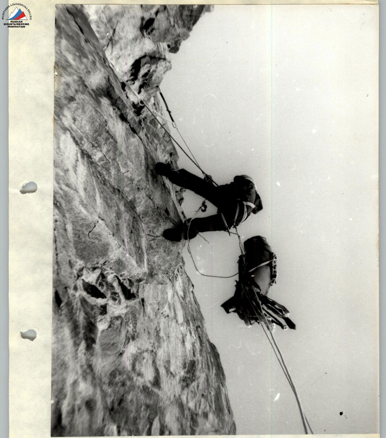
Photo №4. Movement of the second participant on section R21.
Shooting date: July 3, 1987.
Shooting time: 11:00.
Designation of the shooting point on the technical photograph — N4.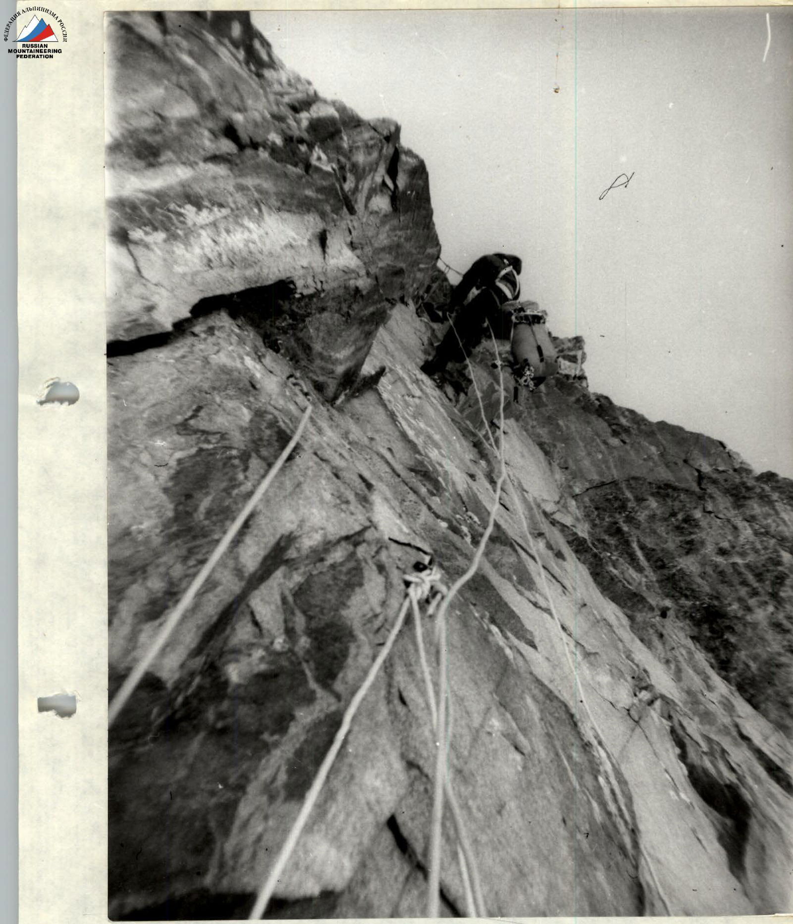
Photo №5. Passing the rope on section R22. Shooting date: July 3, 1987. Shooting time: 12:00. Designation of the shooting location on the technical photograph — N5.