TO THE ALPINISM FEDERATION OF THE USSR
Report
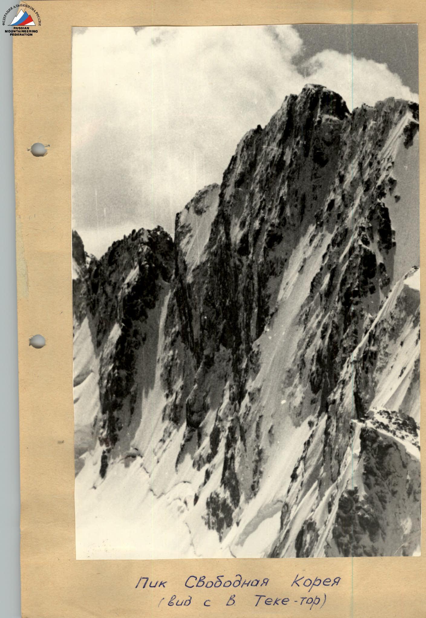
On the ascent of Pik Svobodnaya Korea via Route 6B cat. diff.
 The route leads directly to the summit ridge, 80 m from the cairn, in a beautiful straight line. The lower part of the route is steep ice, the middle section is a sheer rocky wall with ice formations, and the upper part is a very steep ice-rock ridge.
The route took first place in the 1969 USSR championship and is classified as a 6B category difficulty route.
III. Preparation for the Ascent
The team first became familiar with the climbing conditions in the area in 1967. The harsh climate and technical difficulty of the routes required serious preparation.
The general physical training program included:
- Cross-country running
- Games
- Skiing
- Gymnastics
Team members took monthly fitness tests.
Specialized training included winter outings to rocky areas to practice moving on icy rocks in freezing conditions, as well as summer (May, June) outings to practice individual climbing techniques and movement using artificial aids.
Serious attention was given to creating modern equipment.
The ascent was planned in the winter, and the team studied the report of the first ascenders, discussing their itinerary and tactics.
During their stay in the mountains, the team made an ascent of the 5th tower of the Corona via the western wall, a 5B category difficulty route (1968, 4th place in the USSR championship). The ascent was made in bad weather over 3 days and showed that the team was ready to tackle the route.
While out on the Axsay Glacier, the team observed the route through a 40x telescope.
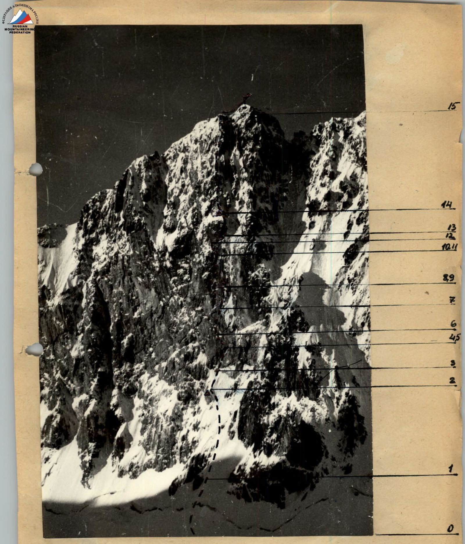
Ascent route (– bivouac locations)
VI. Ascent Chronicle
July 27. A group of four: Bakurov, Zayonchkovsky, Logachev, and Kalmykov, set out from the camp. They left early to make their way through and observe the wall without rushing. Their backpacks were not heavy, as the main equipment and supplies had already been transported to the glacier moraine. Gorenchuk and Lurie stayed behind in the base camp, delayed by various tasks.
July 28. At 3:00, the duo Bakurov – Kalmykov departed to begin processing the route. They were seen off with encouragement and wishes of success. Their task included not only processing the route but also transporting tents and most of the equipment to the "knife-edge." They moved slowly, as expected, given the steep ice, which was up to 70° in some places. They reached the "knife-edge" by 10:00, where they leveled a shelf for the night, set up a tent, and observed the wall above. They returned to the tents by 16:00, at the same time as Gorenchuk and Lurie. The cornice looked imposing, but the ice "knife-edge" was gentler than expected.
July 29. The team departed at 3:00 without breakfast, planning to eat on the "knife-edge." By 7:00, they were already cooking. Using the pre-fixed ropes, they ascended quickly and calmly. At 8:00, the duo Zayonchkovsky – Kalmykov went ahead to continue processing the route, while the others took a rest day.
Their tasks for the day included:
- Leveling the platform
- Gathering two backpacks with supplies and gear
- Lifting them up to the wall via the "knife-edge"
- Brewing tea
- Discussing the route
- Observing other groups moving up and down the glacier
The processing duo worked diligently, with ice and then rocks flying down. However, the "knife-edge" deflected the debris to the sides, sparing the rest of the team.
The passage of the cornice was particularly impressive, followed by the wall. The team used pitons, ladders, and continuous ice removal, as there was a lot of ice due to recent bad weather. Sanya (presumably one of the climbers) had a tough time but eventually reached the first night's bivouac site of the first ascenders.
July 30. At 7:00, the duo Gorenchuk – Lurie departed to continue leading the way. The others "rested," preparing their backpacks.
The first rope of the day provided immense pleasure for the entire team, with challenging climbing that was enjoyable despite the half-kilometer void below.
The next rope was technically more difficult and nerve-wracking, with large, rust-colored blocks that were sometimes overhanging and precariously balanced.
This rope led to a challenging bivouac site – a 30 cm wide ledge for three people, with some uncertainty about the others' arrangements.
Four pitons were hammered in for the night's bivouac. Further progress required traversing to the inner angle, where the first ascenders had set up a "pendulum" traverse. The team managed to climb through, albeit with great difficulty, particularly when having to remove ice from the ledge while holding on with one hand above their head.
By the end of the day, Gorenchuk managed to ascend another 30 meters up very steep, ice-covered rocks. The rope ended at a precarious spot, requiring the next day's leader to stand in ladders while belaying.
July 31. Today was a challenging day with a cornice, overhangs, and a difficult night's bivouac ahead. Nonetheless, the team was hopeful about reaching the ridge.
The leader went ahead again, navigating extremely difficult climbing through the angle. The cornice was passed using 4 ladders, followed by ice-covered slabs requiring more ice removal.
After removing a large slab of ice, they found the pitons left by the first ascenders, indicating their bivouac site. Three more pitons led upwards, then to the right.
This traverse was the most unpleasant part of the wall, with heavily broken, overhanging rocks leading to an ice-rock wall.
It was difficult to discern the terrain – whether it was ice-covered rocks or ice with rock outcrops. Steps were cut, and ice and rock pitons were hammered in. Finally, a shout of triumph was heard as the first climber reached the ridge. Two more hours were spent in complex operations to pull up the backpacks on two ropes with a traverse. By nightfall, everyone was gathered at the bivouac site under an overhanging rock.
August 1. The team woke up late, with the first duo, Logachev – Kalmykov, departing at 9:00. The others lightened their loads by hanging a 2-liter canister of fuel on a piton and discarding unusable pitons. They had to carry their backpacks on their backs but still had to pull them in two places due to the terrain.
The terrain varied, including rocky walls, steep ice sections, and ice-covered rocks. To be efficient, one member of the first duo remained in crampons at all times, switching as the terrain required. Finally, after breaking through a small cornice, the first climber reached the ridge. They descended a rope's length and set up comfortable platforms.
They departed at 9:00 and began their descent by 10:00, reaching the ground in 3 hours.
Excerpts from the Ascent Debriefing
Attendees:
Representative of the USSR Alpinism Federation – M.E. Gruzinsky. Head of the "Ala-Archa" Alpine Camp – V. Sukhanov (participant in the first ascent). Head of KSP – A. Aitbaev. V. Bezzubkin (leader of the first ascent) and the entire team of the LOS SDSO "Burevestnik" collection.
Gorenchuk: "The route is excellent, with no section where you can relax; it demands constant attention. Technically, it's an order of magnitude more challenging than any 5B route I've done. Comparable in technique and labor intensity to the north wall of Maria, but there, the difficulties are spread over twice the length with some easier sections. The route is great because you can and must climb it. If you rely on artificial aids, it will take significantly more time."
"I am pleased with the team members; there are no complaints. Everyone worked with full dedication, giving their all to complete the route."
Zayonchkovsky: "I have no complaints about the ascent. I consider our tactics optimal for this route."
"Comparing it to the route on Pik Engels in the previous year, I can say that Korea is interesting both technically and tactically. Korea is more challenging in terms of bivouacs and climbing, while Engels has better bivouac sites and most of the wall section is done with artificial aids. It's hard and tiring but less enjoyable. The route is undoubtedly a 6B."
Kalmykov: "An excellent route. I've never climbed anything like it before. Can't compare it to any of my 5B climbs." "The 45 m rope we used this year was very effective, just enough for comfortable belays."
Bezzubkin: "...We had 40 m ropes and really struggled."
Lurie: "...Very satisfied with the ascent and the team. On this occasion, I express our collective admiration for the fighting qualities of the Kyrgyz team, who reached our wall bivouac in bad weather..."
Gruzinsky: "...The team completed the route very well. The pace, tactics, and style of climbing left a great impression..." "...The sportsmanship of the entire 'Burevestnik' gathering, the good organization, and discipline should also be highly praised..." "...Taking advantage of my seniority, although I wasn't the one who cleared the team, I propose that the ascent and leadership be recognized."
I. Team Composition
The ascent was made by the team of LOS SDSO "Burevestnik" consisting of:
- Gorenchuk Yu.F. – leader (Master of Sports)
- Bakurov V.A. – participant (Candidate for Master of Sports)
- Kalmykov S.G. – participant
- Logachev Yu.A. – participant
- Lurie V.A. – participant
- Zayonchkovsky A.Ya. – participant
The ascent was made as part of the training camp of the LOS SDSO "Burevestnik" alpine team in the "Ali-Archa" area from July 28 to August 2, 1970.
Senior coach of the team – Master of Sports F.N. Zhitenyov.
II. Brief Geographical Description of the Area. Climbing Conditions in the Area. Sporting Essence of the Object
Pik Svobodnaya Korea is located in the western spur of the Kyrgyz Ala-Too ridge, in the Axsay Glacier area. On the Axsay Glacier, Pik Svobodnaya Korea (4740 m) drops with its thousand-meter, ice-covered, practically sheer north wall. The north wall is about a kilometer wide. From the south, from the Top-Karagai valley, the summit ridge is approached by a chaotic jumble of heavily destroyed counterforts and dangerous steep couloirs.
The weather in the Axsay area is typically "Tien Shan-like" – usually sunny until 2-3 pm, followed by snow and wind later. There are, of course, periods of stable weather, both good and bad.
The north wall of Korea has long been popular among climbers, as evidenced by the fact that four routes have been laid through the wall, with three being "golden" and one "silver."
Our team followed the route pioneered by the Krasnoyarsk GKFK team under the leadership of V. Bezzubkin.
Table of Main Route Characteristics
| Dates | Section | Average slope of section /degrees | Length of section /m/ | Characteristics of sections and climbing conditions | Technical difficulty | Method of overcoming and belaying | Weather | Time | Pitons driven | Bivouac conditions | Daily ration weight |
|---|---|---|---|---|---|---|---|---|---|---|---|
| hours | Rock | Ice | Pitons | ||||||||
| 28 | 1 | 45–50° | 100 | Snow slope | Not difficult | Alternating through ice axe | Good | 3:00 | 12 | 8 | |
| 2 | 55–60° | 250 | Ice slope with rock outcrops | Quite difficult | Piton belay, front points | "—" | 15:00 | 12 | 8 | ||
| 29 | 3 | 45–50° upper part up to 70° | 60 | Ice ridge "knife-edge" | Quite difficult | Alternating piton belay, front points | Good | 18:00 | 3:00 | 15 | 2 |
| 4 | 80–85° of | 45 | Destroyed gray rocks | Very difficult | Free climbing with piton belay | "—" | 6 | ||||
| 5 | 1.5 | Cornice | Very difficult | Artificial holds | "—" | 3 | |||||
| 6 | 85–90° | 40 | Firm, smooth rocks covered with ice | Very difficult | Artificial holds | 15 | |||||
| 30 | 7 | 85° | 45 | Firm rocks with small holds. Lower part covered with ice | Very difficult | Free climbing with piton belays | 19:00 | 7:00 | 6 | ||
| 8 | 90° | 45 | Large blocky, rust-colored rocks. Heavily destroyed, some overhanging | Very difficult | Free climbing with piton belay | 6 | |||||
| 31 | 9 | 90° | 15 | Traverse left to small holds, then a 10 cm wide shelf covered with ice | Very difficult | Free climbing with piton belay | Good | 12 | 3 | ||
| 10 | 85–90° | 75 | Inner corner | Very difficult | Free climbing | Good | 8:00 | 15 | 1 | ||
| 11 | 2 | Cornice | Very difficult | Artificial hold | 3 | ||||||
| 12 | 85° | 25 | Slabs covered with ice | Very difficult | Free climbing | 12 | 7 | ||||
| 13 | 90° | 30 | Traverse right along heavily destroyed, overhanging rocks | Very difficult | Free climbing | 6 | |||||
| 14 | 75° | 60 | Wall covered with ice. Exit to ridge | Difficult | Free climbing, step cutting | 20:00 | 6 | 3 | |||
| 1.08 | 15 | 70–75° | 250 | Steep ridge. Rocks covered with ice. Some pure ice sections | Difficult. Some artificial holds | Good | 9:00 | ||||
| 2.08 | 16 | 80 | Gentle snow ridge | Easy | Ice axe | 9:00 | 1 |
TOTAL:
- Route length – 1125 m.
- Average slope of the route – 75°.
- Length of the most challenging sections – about 400 m.
- Backpack hauling – 450 m.
- Slope of the most challenging sections – 85°.
- Pitons driven: rock – 119, ice – 34, pitons – 7.
- Climbing hours – 62.
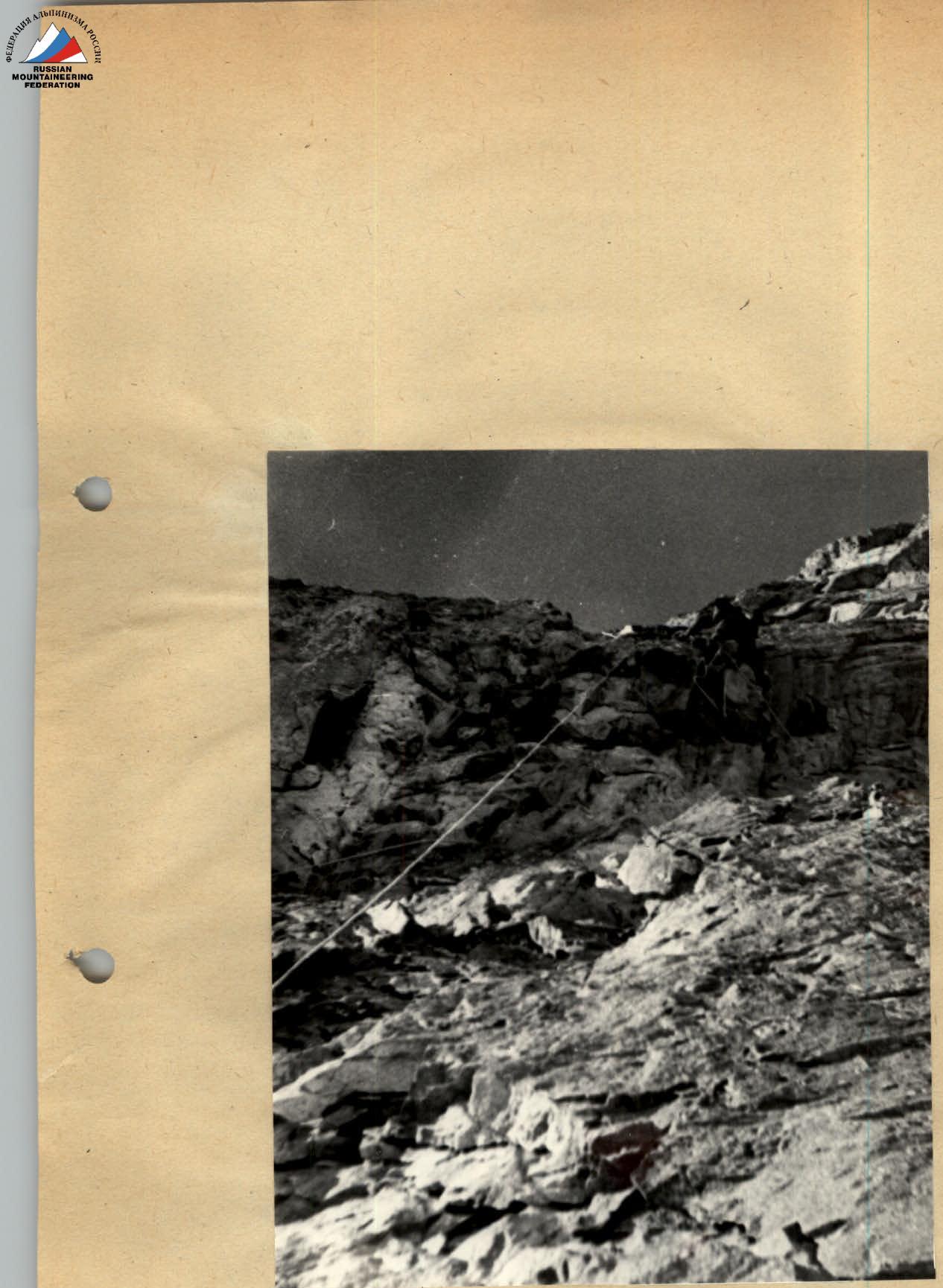
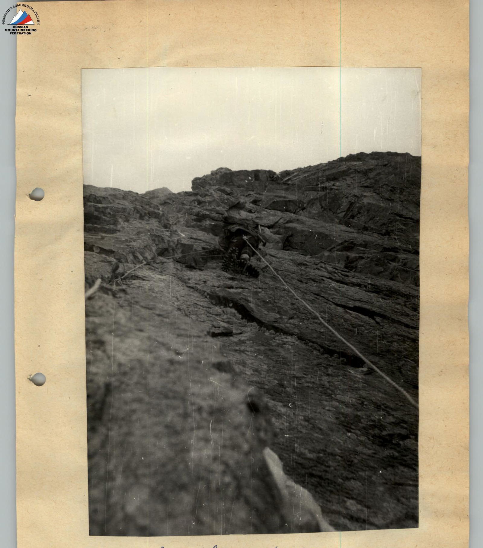
Under the first cornice
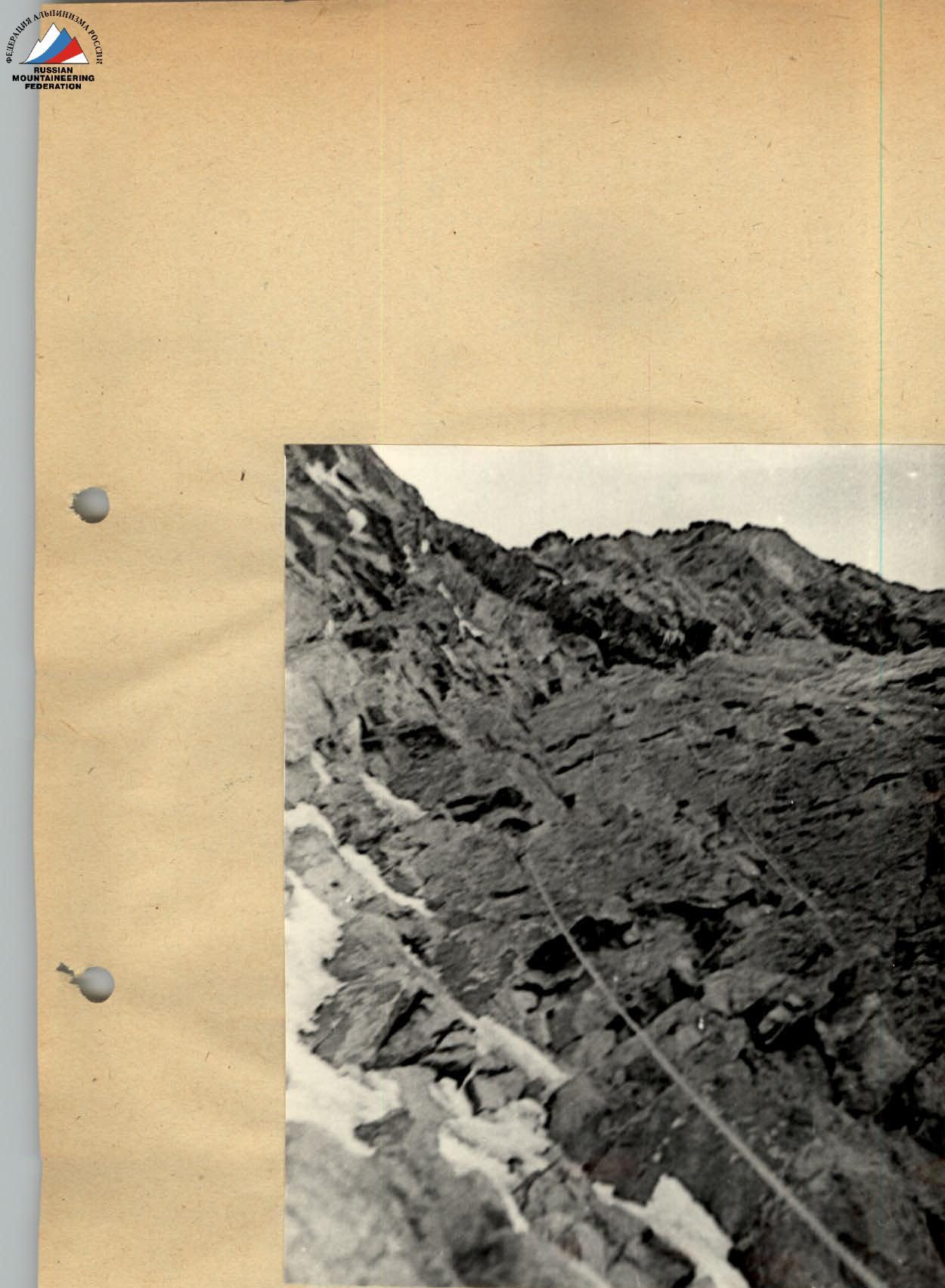
Second cornice