
Passport
- Climbing category — technical
- Tian-Shan, Kyrgyzsky Ridge, Ak-Sai gorge
- Peak Svobodnoy Korei via the left triangle of the northern wall
- Category 6B, first ascent
- Height difference 700 m, length 1160 m.
- Wall section height difference 520 m.
- Length of 6A–6B category section 280 m.
- Average steepness of the main part of the route –75°
- Equipment used on the route:
- 137 chocks, 92 rock pitons, 3 bolt pitons, 39 ice screws.
- Climbing hours – 30 h, days – 3
- Overnights: 1st – on a ledge under the base of the triangle, 2nd – on a platform in a tent.
- Team leader: Balyazin Valery Viktorovich — Master of Sports of International Class
- Zakharov Nikolay Nikolaevich — Master of Sports of International Class
- Savelyev Vyacheslav Anatolyevich — Master of Sports
- Kuznetsov Pyotr Vladimirovich — Master of Sports
- Team coach: Zakharov Nikolay Nikolaevich
- Approach to the route July 5, 1991
- Summit July 7, 1991
- Descent July 7, 1991
- Climb organized by "Yenisei" sports club, Krasnoyarsk

Taken with "Smena" on July 2, 1991
- Shooting height ≈ 3900 m
- Distance ≈ 2000 m
- Point #2.

Wall profile from the right
Taken on July 2, 1990 at 10:00. Helios lens F=58.
- Shooting point height about 3900 m
- Point #1, distance 1.5 km.
Tactical actions of the team
The team started moving from the bergschrund at 4:10. The rope team Kuznetsov — Savelyev worked ahead, with Kuznetsov leading the first 7 ropes, then Savelyev took over. They reached the planned overnight location at 15:00, set up a tent, and processed 8 m. The weather worsened, and it started snowing. They stopped processing and settled in for the night at 16:00.
The next day, the rope team Balyazin — Zakharov continued processing the route at 7:20. Balyazin worked ahead. Climbing was very challenging, with few good cracks, and a steepness of 100°. The weather was poor: snow, fog. They processed 3 ropes. They stopped for the night at 18:00 at the same location. The next day, they started working at 5:30. At 10:00, they reached the ridge. The rope team Balyazin — Zakharov worked ahead. The weather worsened, with heavy snowfall and fog, reducing their speed. They reached the summit at 13:30, 1 hour 30 minutes behind schedule. Otherwise, they followed the tactical plan.
For the first seven ropes, they used ice screws for belays. Belay stations were set up on two linked ice screws. On rock sections, belay stations were organized with at least three linked points (chocks, pitons). They used a wide range of chocks and pitons for climbing and belaying.
For intermediate belay points, they used imported quickdraws with two carabiners. On challenging sections R7, R8, R9, R10, R11, R13, they frequently used pendulums. For aid climbing, they used hook clippers. There were no falls or injuries.
The team was technically and physically well-prepared, well-equipped, mostly with imported gear (ropes, carabiners, quickdraws, ice axes, helmets, crampons, vibram soles, clothing, etc.).
The team worked very cohesively, despite bad weather, and maintained regular contact with observers according to schedule. The rescue team was stationed at "Ratsek" and Koronskie overnight locations.
Overnight stays were organized under the overhang of the rock triangle and were completely safe. While processing the route, they moved with a leftward bias, and rocks falling from under the working rope team went significantly to the left.
Diet: hot breakfast and dinner in the morning and evening; pocket food (dried apricots, raisins, etc.) during the day.
Food and fuel table
| Item | Quantity |
|---|---|
| 1. Dehydrated mashed potatoes | 0.6 kg |
| 2. Dehydrated cottage cheese | 0.6 |
| 3. Smoked lard | 0.8 |
| 4. Bouillon cubes | 0.05 |
| 5. Chocolate candies | 0.6 |
| 6. Rusks | 0.5 |
| 7. Tea | 0.1 |
| 8. Condensed milk | 0.8 |
| 9. Boiled potatoes | 0.5 |
| 10. Onion | 0.2 |
| 11. Garlic | 0.2 |
| 12. Apples | 1.0 |
| 13. Dried apricots | 0.5 |
| 14. Raisins | 0.5 |
| 15. Gas canisters, 2 pcs. | 0.8 |
| Total: | 7.8 |
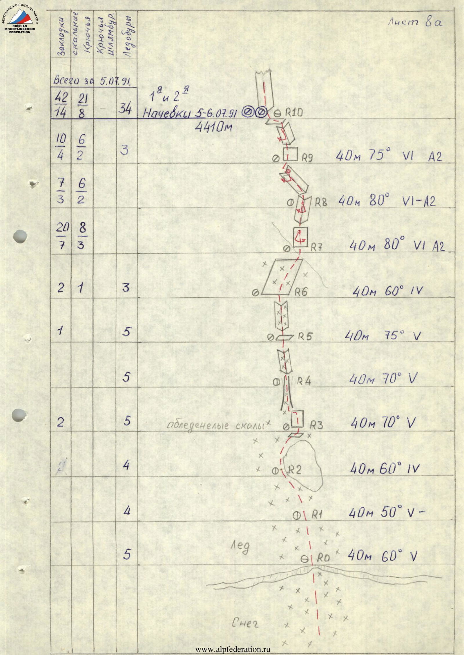
Equipment data for July 5, 1991 (by sections)
| Section | Chocks | Rock pitons | Bolt pitons | Ice screws |
|---|---|---|---|---|
| R10 | 34 | |||
| R9 | 10 | 6 | 4 | 2 |
| R8 | 7 | 6 | 3 | 2 |
| R7 | 20 | 8 | 7 | 3 |
| R6 | 2 | 1 | 3 | |
| R5 | 1 | 5 | ||
| R4 | 5 | |||
| R3 | 2 | 5 | ||
| R2 | 4 | |||
| R1 | 4 | |||
| R0 | 5 |
Total for July 5, 1991:
| Chocks | Rock pitons | Bolt pitons | Ice screws |
|---|---|---|---|
| 42 | 21 | 14 | 8 |
Overnights July 5–6, 1991 at 4410 m.
Route profile (Sections R0–R10)
- R10: 40 m, 75°, VI A2
- R9: 40 m, 80°, VI–A2
- R8: 40 m, 80°, VI A2
- R7: 40 m, 60°, IV
- R6: 40 m, 75°, V
- R5: 40 m, 70°, V
- R4: 40 m, 70°, V (icy rocks)
- R3: 40 m, 60°, IV
- R2: 40 m, 50°, V–
- R1: 40 m, 60°, V (ice)
- R0: 40 m, 60°, V (snow)
Total equipment data (for the entire route)
| Chocks | Rock pitons | Bolt pitons | Ice screws |
|---|---|---|---|
| 137 | 92 | 3 | 39 |
Equipment data for July 6, 1991
| Chocks | Rock pitons | Bolt pitons | Ice screws |
|---|---|---|---|
| 42 | 35 | 3 | |
| 56 | 54 | 3 | |
| 17 | 12 | ||
| 24 | 7 |
Climbing hours: 30 h. Peak Svobodnoy Korei: 4740 m. Sharp snowy ridge: 600 m, 30°, IV–V–
- 40 m, 90°, VI A2
- 40 m, 100°, VI+ A3
- 40 m, 100°, VI+ A4
- 40 m, 100°, VI+ A4

Route description by sections
- R0–R3: Ice slope.
- R3–R4: Icy slabs, transition left into an ice gully.
- R4–R5: Steep ice gully turning into an icy internal corner.
- R5–R6: Internal corner filled with ice.
- R6–R7: Snow-ice slope, approach to a steep rock wall.
- R7–R8: Steep wall turning into a broken internal corner, upper part with aid climbing.
- R8–R9: Steep broken internal corner, use of aid climbing, exit into an internal corner going left.
- R9–R10: Snowy and icy rocks. Exit left onto a snow ledge under the base of an overhanging corner. Overnight location.
- R10–R11: From the overnight location, two large overhanging internal corners go up. Movement is along the left corner. Few aid climbing opportunities at the start, and most are blunt. Petal and short pitons are necessary. Further on, chocks are used. Under a cornice (about 20 m) — pendulum left, bypassing the cornice with aid climbing on the left (3 bolt pitons hammered in). Then aid climbing up the corner. Hanging belay station.
- R11–R12: Ascent goes up the corner with narrow cracks (aid climbing). The cornice is passed on the right part of the corner (aid climbing). Steepness about 100°. Hanging belay and belay station. For the belayer's convenience, a sitting platform is recommended.
- R12–R13: Internal corner, then a wall to the right and again an internal corner with a wide crack; water flows on the left side of the corner, with some ice forming in places. Chocks, offset nuts, and friends go well. Belay station on a small ledge.
- R13–R14: Further ascent goes along an indistinct ridge to the right of a steep gully filled with ice. Exit onto a gentle snowy ridge that connects with the main ridge after 15 m.
- R14–R15: Summit ridge about 600 m, half of which is quite challenging: sharp ridge with gaps, snowy cornices, complicated belaying. The route mainly follows the ridge, with possible bypasses on the left. Lots of snow.

Passage of sections R7–R8. Photo #1. Shooting point R7.
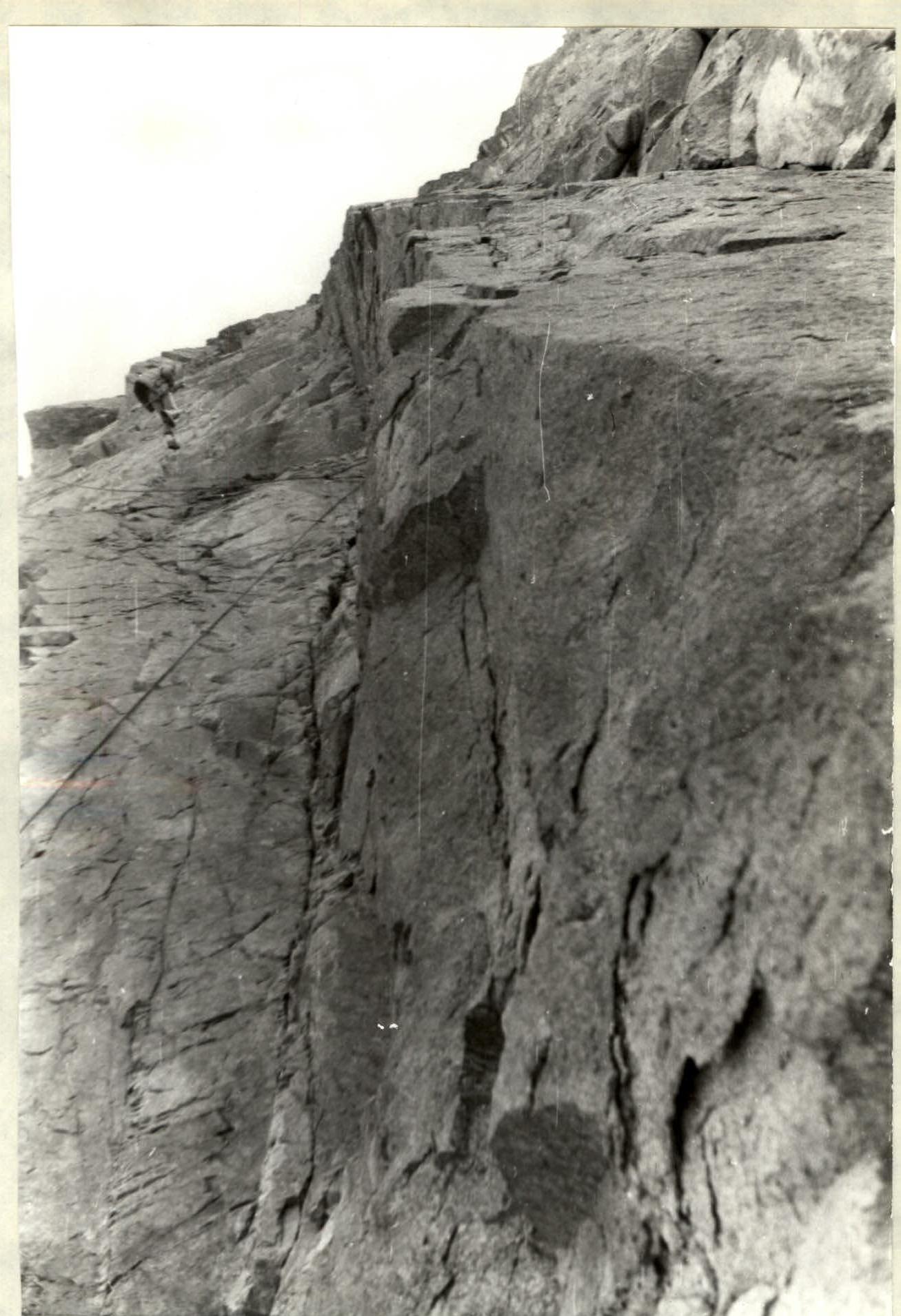
Photo #3. Section R10–R11. Descent after processing to the overnight location. Taken from the R10 overnight location.
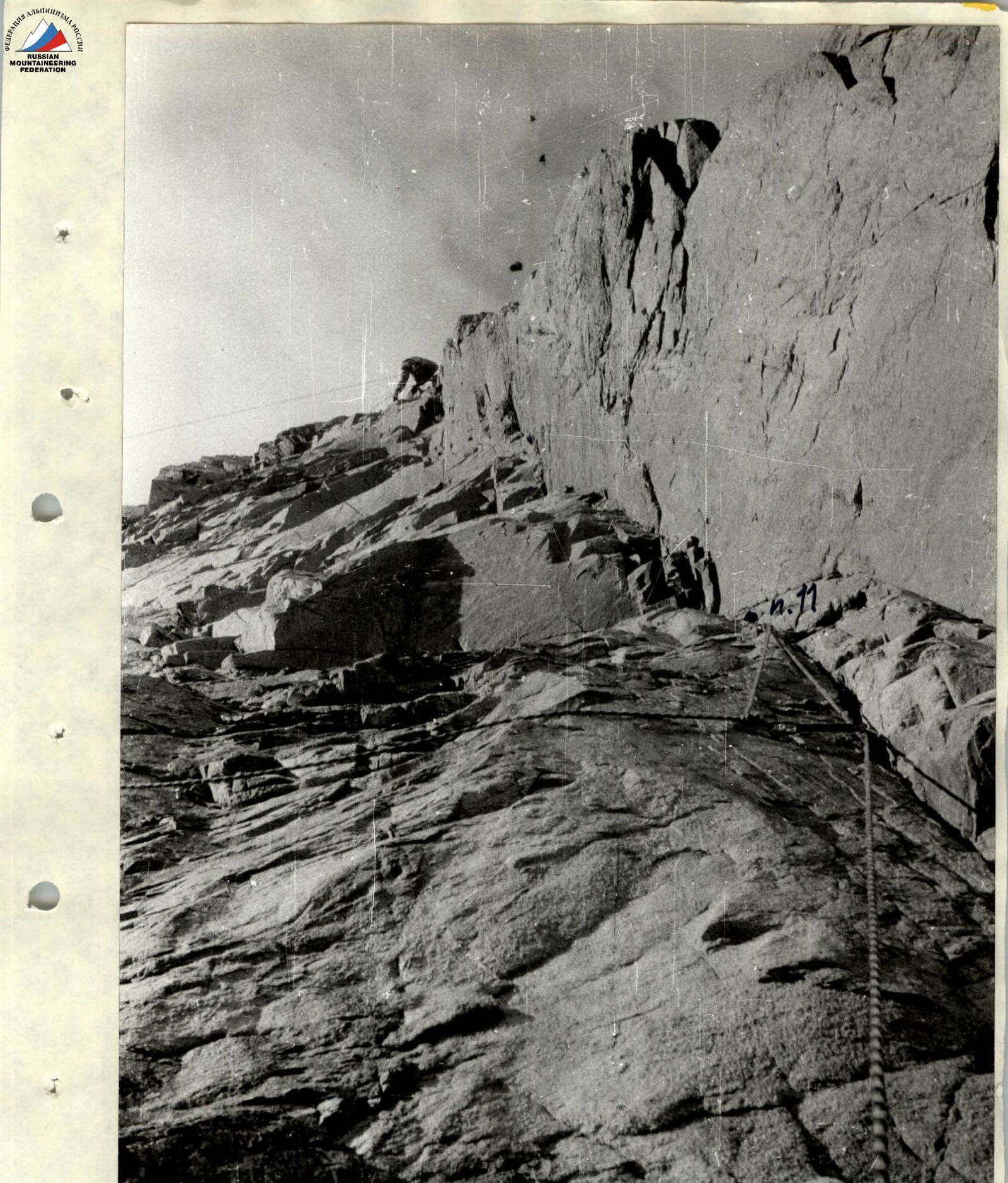
Photo #4. Passage of the processed section R11–R12. A freely hanging rope on a climber indicates the steepness of the section. Taken from the R10–R11 fixed rope.
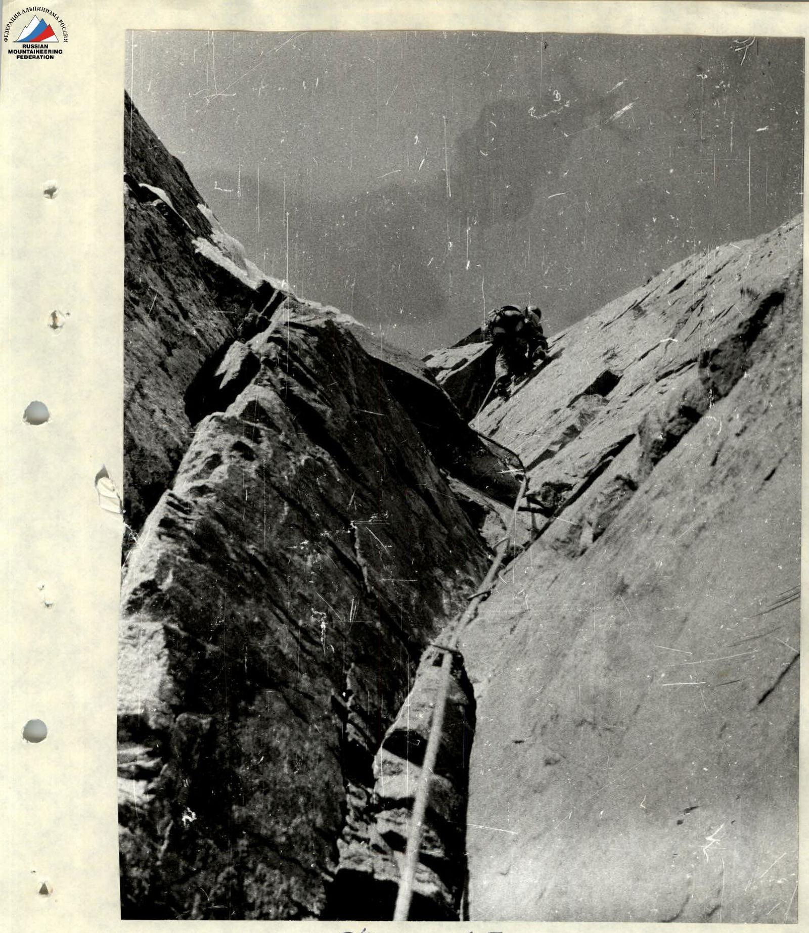
Photo #7. Passage of the cornice in the middle part of section R13–R14. Taken from R13.