Ascent Log
- High-altitude technical category.
- Tian Shan, Kyrgyz Ala-Too Range, Ak-Sai valley.
- Svobodnaya Korea Peak. Right edge of the North face. 4740 m.
- Route 5B category of difficulty (L. Myshlyaev, 1961).
Approximately the fourth ascent of the route.
- Height difference of the route: 640 m (bergshrund 4100 – summit 4740).
Route length 845 m.
-
Length of the central part 270 m.
-
Length of sections with 6th category: 235 m.
-
Average steepness of the route: 65° (bergshrund – ridge).
-
Average steepness of the central part: 83°.
-
Number of pitons driven:
- rock pitons 82/12
- bolt pitons 0/12
- chocks 0/20
- 12
- ice screws 0/30
-
Team's travel time: 26 hours. Days: 2.
-
Overnight stays: 1 sitting.
Participants:
- Kirikov Alexander Vyacheslavovich – CMS
- Medvedev Konstantin Rakhimyanovich – CMS
- Departure to the route: August 28, 2000.
Summit: August 29, 2000. Return: August 30, 2000. Organization: Tomsk Alpine Federation. Photo #2 (August 27, 2000)
Route Profile
Svobodnaya Korea Peak (route category 5B by L. Myshlyaev, 1961)
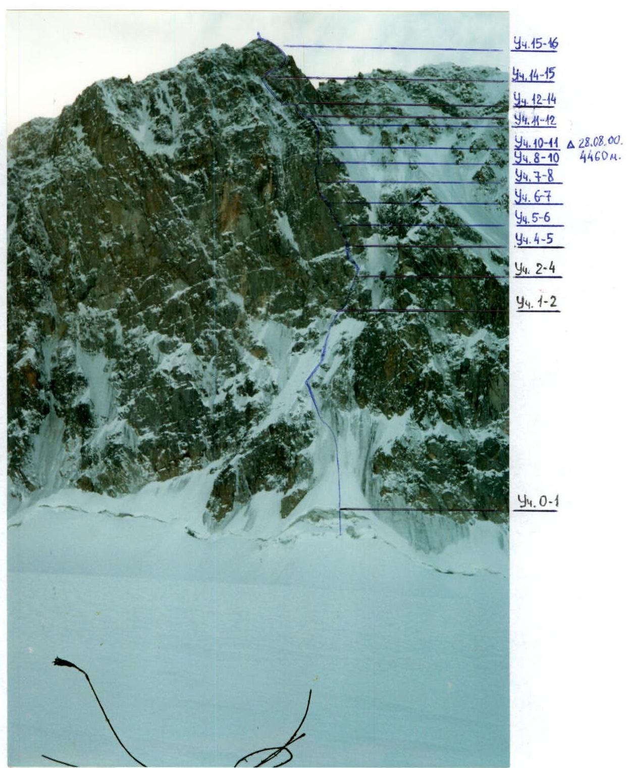
Ascent diagram to Svobodnaya Korea Peak 4740 m via the right edge of the North face 5B category (L. Myshlyaev, 1961) in UIAA symbols
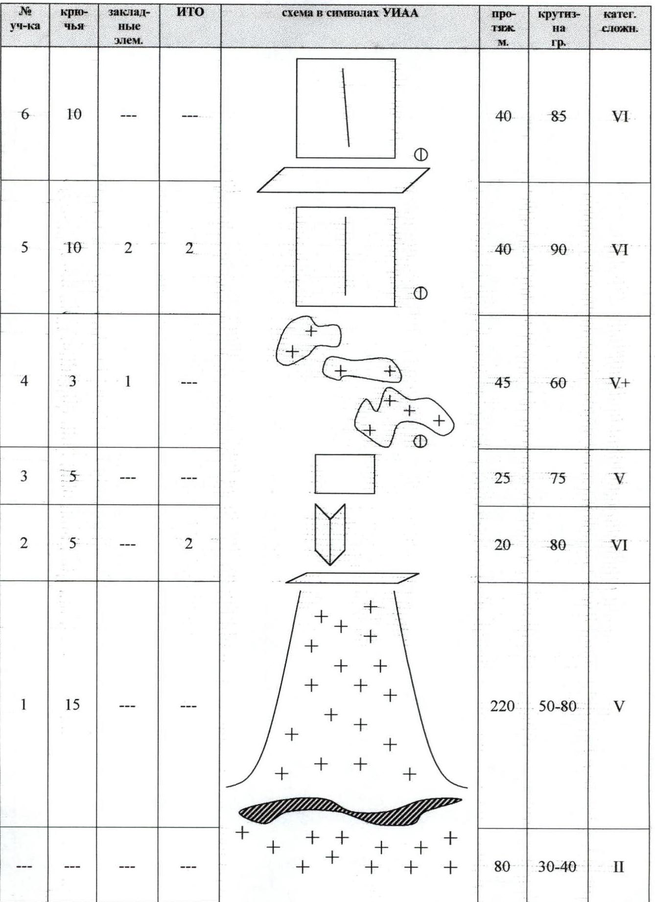
| Section # | Pitons | Chocks | ITO | Length, m | Steepness, ° | Category |
|---|---|---|---|---|---|---|
| 6 | 10 | --- | --- | 40 | 85 | VI |
| 5 | 10 | 2 | 2 | 40 | 90 | VI |
| 4 | 3 | 1 | --- | 45 | 60 | V+ |
| 3 | 5 | --- | --- | 25 | 75 | V |
| 2 | 5 | --- | 2 | 20 | 80 | VI |
| 1 | 15 | --- | --- | 220 | 50–80 | V |
| --- | --- | --- | --- | 80 | 30–40 | II |
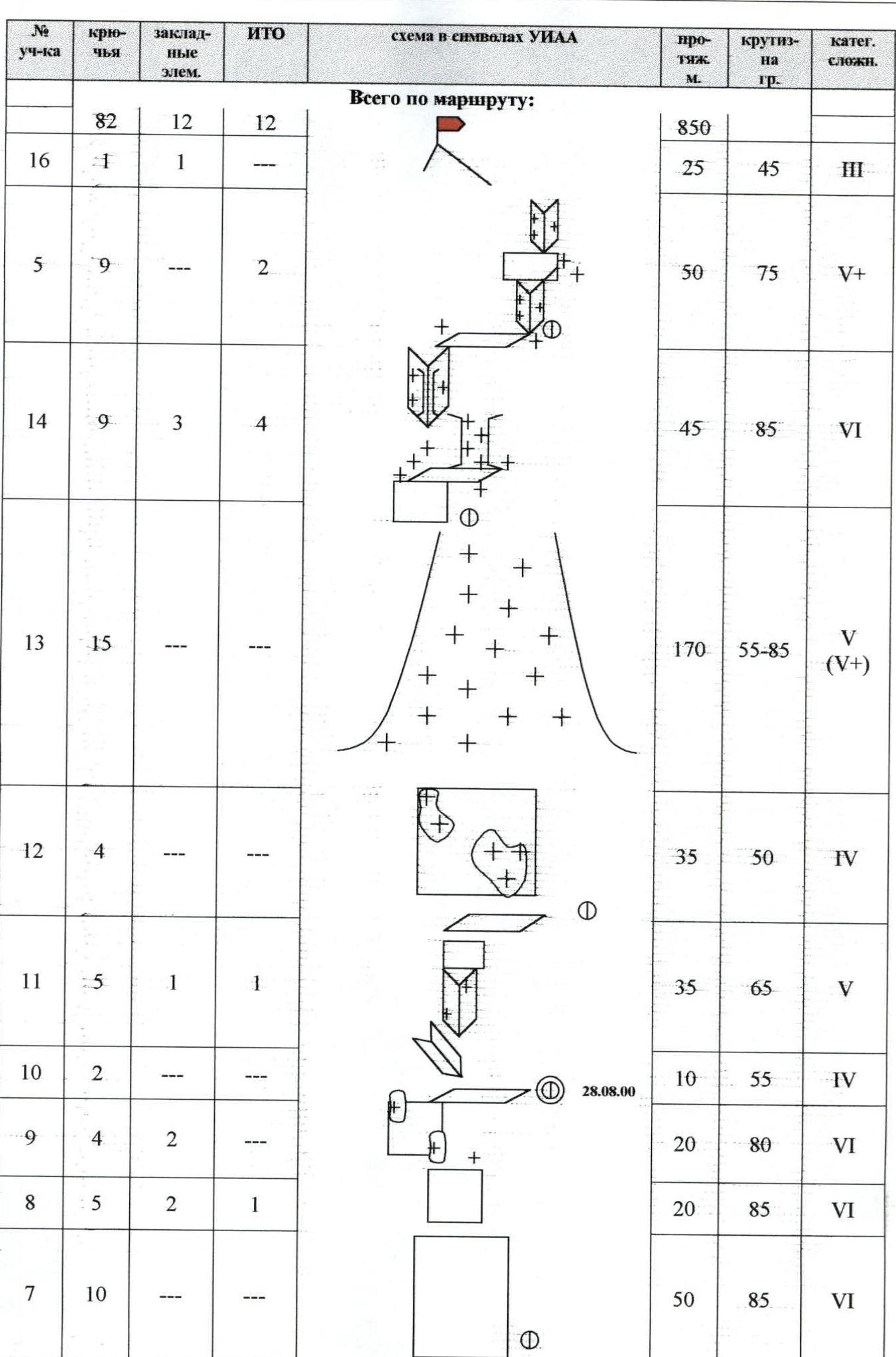
Total for the route:
| Section # | Pitons | Chocks | ITO | Length, m | Steepness, ° | Category |
|---|---|---|---|---|---|---|
| 82 | 12 | 12 | 850 | |||
| 16 | 1 | 1 | --- | 25 | 45 | III |
| 5 | 9 | --- | 2 | 50 | 75 | V+ |
| 14 | 9 | 3 | 4 | 45 | 85 | VI |
| 13 | 15 | --- | --- | 170 | 55–85 | V (V+) |
| 12 | 4 | --- | --- | 35 | 50 | IV |
| 11 | 5 | 1 | 1 | 35 | 65 | V |
| 10 | 2 | --- | --- | 10 | 55 | IV |
| 9 | 4 | 2 | --- | 20 | 80 | VI |
| 8 | 5 | 2 | 1 | 20 | 85 | VI |
| 7 | 10 | --- | --- | 50 | 85 | VI |
Route Description by Sections
Firn 30–40°, 60–80 m to the bergshrund. Simultaneous movement.
Overnight stay location. (Sitting bivouac)
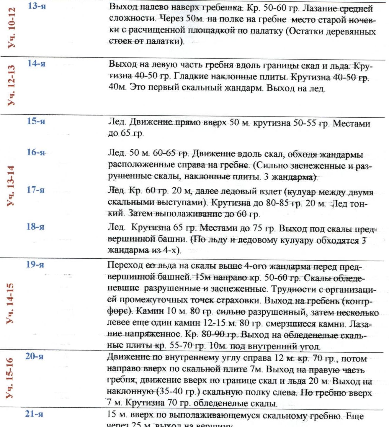
Photo #3 (August 27, 2000) Technical photograph of the route

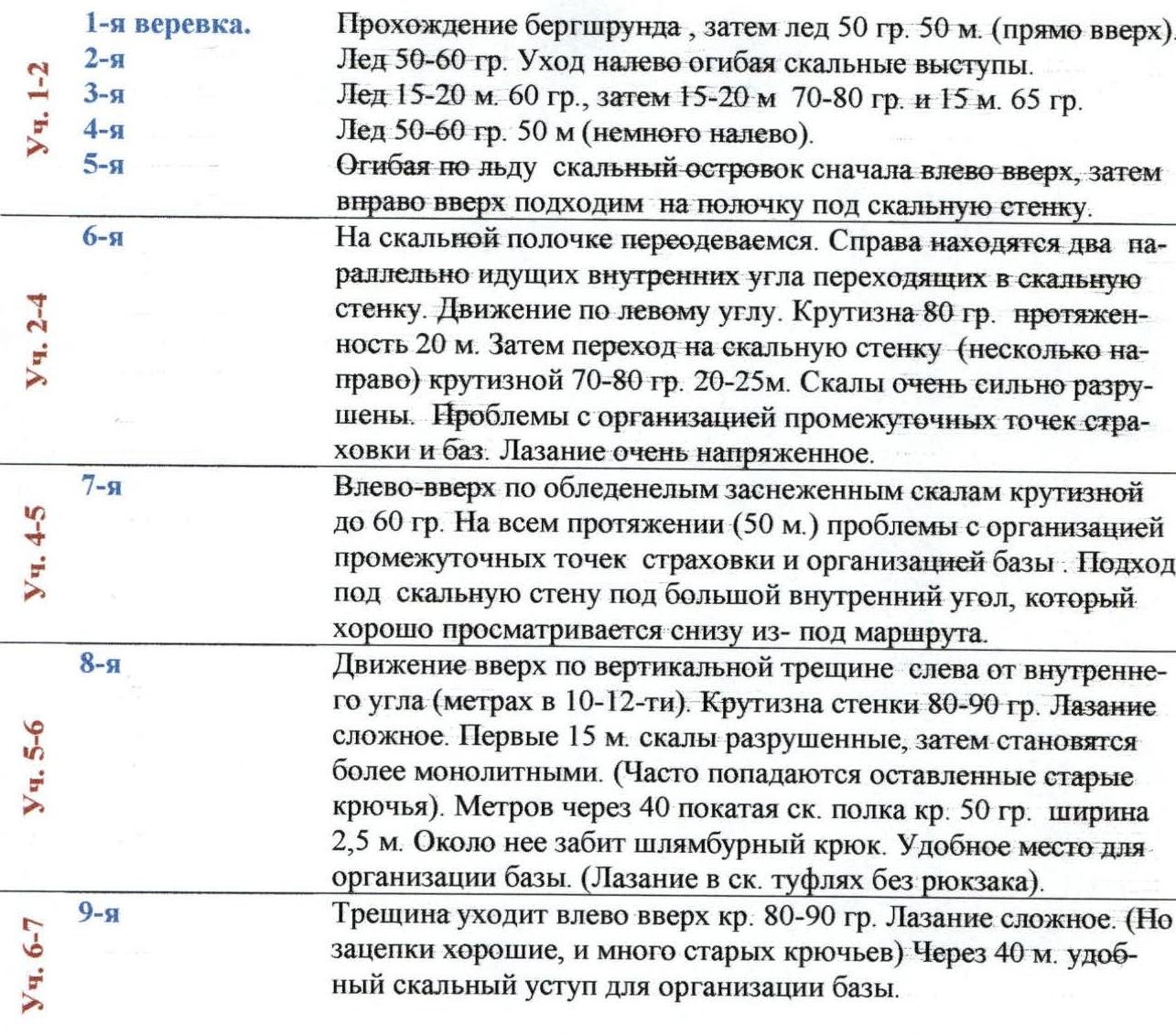
Section R1–R2
- 1st rope. Crossing the bergshrund, then ice 50°, 50 m (straight up).
- 2nd. Ice 50–60°. Moving left, avoiding rock outcrops.
- 3rd. Ice 15–20 m, 60°, then 15–20 m, 70–80° and 15 m, 65°.
- 4th. Ice 50–60°, 50 m (slightly left).
- 5th. Moving around a rock island on ice, first left and up, then right and up, approaching a ledge under the rock wall.
6th
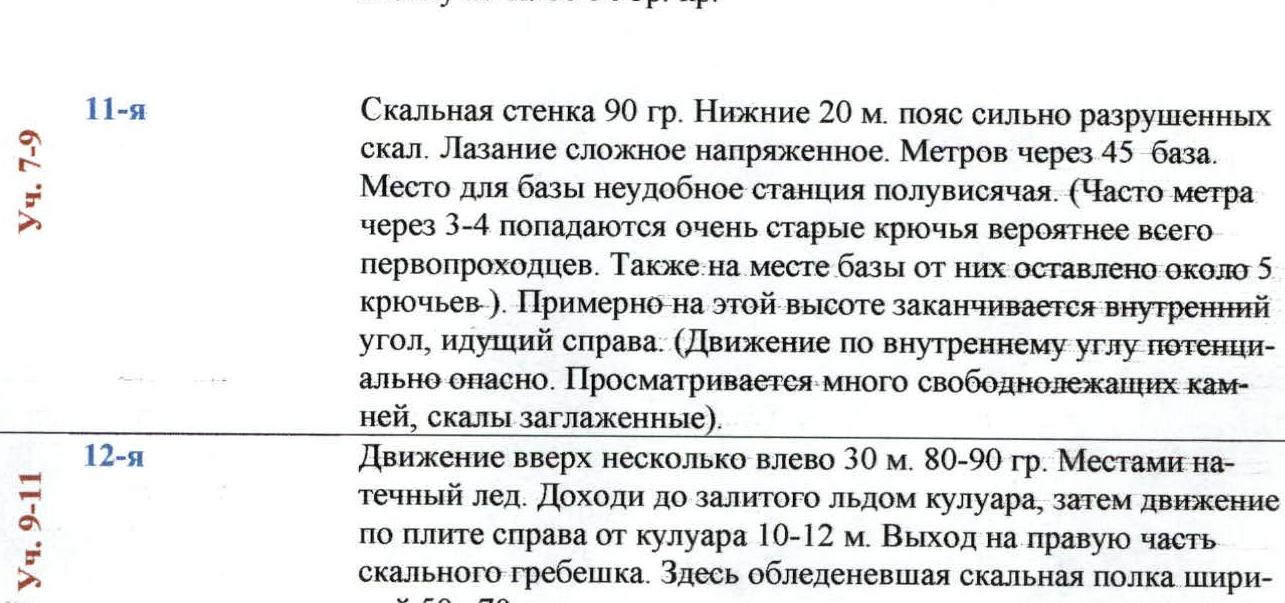
On the rock ledge, we change. To the right are two parallel internal corners turning into a rock wall. Movement is through the left corner. Steepness 80°, length 20 m. Then transition to the rock wall (somewhat to the right) with a steepness of 70–80°, 20–25 m. Rocks are heavily deteriorated. Problems with organizing intermediate belay points and anchors. Climbing is very tense.
Section R4–R5
- 7th. Left and up through icy, snow-covered rocks with a steepness of up to 60°. Throughout the 50 m, there are problems with organizing intermediate belay points and anchors. Approach under the rock wall to a large internal corner, which is clearly visible from below.
Section R5–R6
- 8th. Movement up through a vertical crack to the left of the internal corner (10–12 meters away). Wall steepness 80–90°. Climbing is complex. The first 15 m are deteriorated rocks, then they become more monolithic. (Often, old pitons are found). After 40 m, a sloping rock shelf with a steepness of 50°, 2.5 m wide. Near it, a bolt piton is driven. Convenient place for organizing a belay station. (Climbing in rock shoes without a backpack).
Section R6–R7
- 9th. The crack goes left and up, steepness 80–90°. Climbing is complex. (But there are good holds and many old pitons). After 40 m, a convenient rock ledge for a belay station.
Section R9–R11
- 10th. Lower 10–15 m through a crack left and up, then transition to the wall 25 m, 80–90° steepness.
- 11th. Rock wall 90°. Lower 20 m – a belt of heavily deteriorated rocks. Climbing is complex, tense. After 45 m, a belay station. The belay location is inconvenient, semi-hanging. (Often, every 3–4 m, very old pitons are found, likely from the first ascent. Also, about 5 pitons are left at the belay station by them). Approximately at this height, the internal corner on the right ends. (Movement through the internal corner is potentially dangerous. Many loose rocks are visible, and the rocks are smoothed out).
- 12th. Movement up, somewhat left, 30 m, 80–90°. местами натёчный лёд. We reach an ice-filled couloir, then move along a slab to the right of the couloir 10–12 m. Exit to the right part of the rock ridge. There is an icy rock shelf 50–70 cm wide.
Section R10–R12
- 13th. Exit left to the top of the ridge. Steepness 50–60°. Climbing is moderately complex. After 50 m, on a shelf on the ridge – a site of an old bivouac with a cleared area for a tent (remains of wooden tent poles).
Section R12–R13
- 14th. Exit to the left part of the ridge along the boundary between rocks and ice. Steepness 40–50°. Smooth, inclined slabs. Steepness 40–50°, 40 m. This is the first rock gendarme. Exit to ice.
Section R13–R14
- 15th. Ice. Movement straight up 50 m, steepness 50–55°. местами до 65°.
- 16th. Ice, 50 m, 60–65°. Movement along rocks, bypassing gendarmes located to the right on the ridge. (Heavily snow-covered and deteriorated rocks, inclined slabs. 3 gendarmes).
Section R14–R15
- 17th. Ice. Steepness 60°, 20 m, then an ice pitch (couloir between two rock outcrops). Steepness up to 80–85°, 20 m. Ice is thin. Then the slope eases to 60°.
- 18th. Ice. Steepness 65°. местами до 75°. Exit under the rocks of the pre-summit tower. (On ice and the ice couloir, 3 out of 4 gendarmes are bypassed).
- 19th. Transition from ice to rocks above the 4th gendarme before the pre-summit tower. 15 m to the right, steepness 50–60°. Rocks are icy, deteriorated, and snow-covered. Difficulties with organizing intermediate belay points. Exit to the ridge (counterfort). Chimney 10 m, 80°, heavily deteriorated, then somewhat to the left another chimney 12–15 m, 80°, with frozen stones. Climbing is tense. Steepness 80–90°. Exit to icy rock slabs, steepness 55–70°, 10 m under an internal corner.
Section R15–R16
- 20th. Movement through the internal corner on the right 12 m, steepness 70°, then to the right and up along a rock slab 7 m. Exit to the right part of the ridge, movement up along the boundary between rocks and ice 20 m. Exit to an inclined (35–40°) rock shelf on the left. Along the ridge up 7 m. Steepness 70°, icy rocks.
- 21st. 15 m up along the easing rock ridge. Another 25 m to the summit.