Ascent Passport
-
Category — technical
-
Tian-Shan, Aksai gorge
-
Peak Svobodnaya Korea via the right part of the northern wall
-
Claimed — 5B cat. diff., first ascent
-
Height difference 970 m, length — 1200 m, length of the wall section of the route — 1080 m, length of sections with 5 cat. diff. — 560 m, average steepness of the main part of the route — 70°
-
Pitons driven:
Rock Bolt Nuts Ice 38/0 0/0 12/0 53/0 -
Climbing days (excluding descent) — 1, hours — 17
-
Number of bivouacs and their characteristics — one, on descent, on a gentle scree ridge
-
Leader — Artamonov Alexey Vladimirovich — Candidate Master of Sports
Team members:
- Zolin Igor Pavlovich — 1st sports category
- Ivanov Alexander Vasilievich — Candidate Master of Sports
- Yashin Igor Ivanovich — Candidate Master of Sports
-
Coach — Sobolev Sergey Sergeevich — Candidate Master of Sports
-
Route entry — July 16, 1984 Summit — July 16, 1984 Return — July 17, 1984
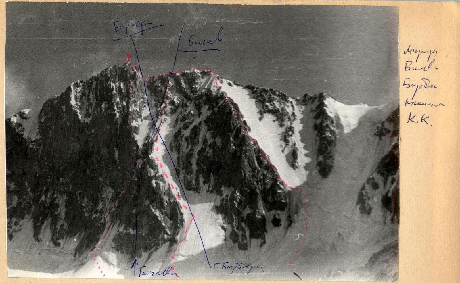
General photo of the summit.
- First ascent route
- Myshlyaev's route, 5B cat. diff.
- 5A cat. diff. route
Camera "Siluet-electro", lens "Triplet 69–3.4/40", shooting point #I, H = 3600 m, shooting time 17:00
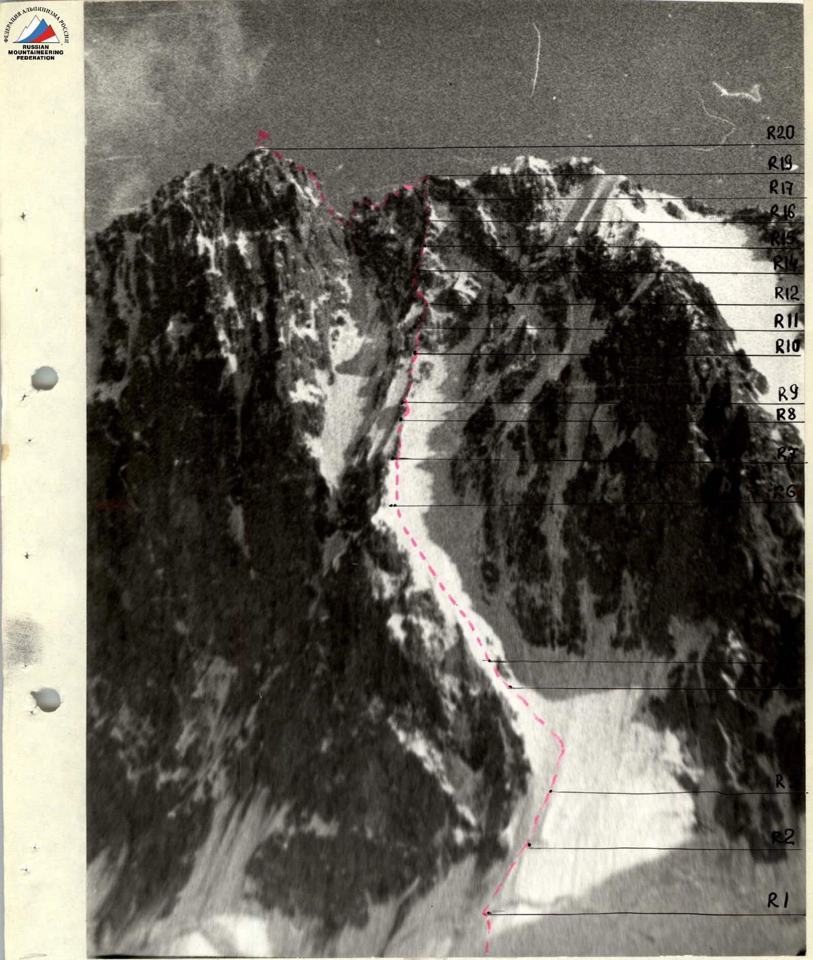
Technical photo of the route. Shooting point #I, H = 3600 m, shooting time — 17:00. Camera "Siluet-electro", lens "Triplet 69–3.4/40"
Team's Tactical Actions
The tactical plan for the ascent included:
- A 24-hour observation of the route immediately before the ascent.
- Day one — departure for the route at 2:00, traversing the ice couloir and reaching the counterfort by 8:00 (no later than 9:00). Movement along the counterfort and reaching the pre-summit ridge by 18:00. Bivouac on the ridge.
- Day two — ascent to the summit, descent into the Top-Karagay gorge, return to the camp.
In case of lagging behind the movement schedule, a possible bivouac on the counterfort was considered, as well as an emergency descent via the ascent couloir in the morning hours (before 9:00).
Team's Actions
After a 24-hour observation of the route, the group departed from the bivouac at Koronskie nochyovka at 1:30 on July 16. At 2:30, they began working on the steep ice. The first six ropes on ice were climbed by the rope team Zolin — Artamonov, with Zolin leading. The technique used was rope team following rope team. The next six ropes on ice were climbed by the rope team Yashin — Ivanov, with Yashin leading. At 8:00, the group reached the shoulder of the counterfort above the β-shaped couloir.
After breakfast, from 8:00 to 9:00, work on the counterfort continued. The movement technique remained the same. The first person moved on a double rope. Artamonov led 6 ropes, Zolin led 4, and Yashin led the rest. At 17:00, they reached the ridge of Svobodnaya Korea. Considering the advancement of the movement schedule, excellent weather, and good condition of the group members, it was decided to ascend to the summit without waiting for the next day and to organize a bivouac on descent.
At 18:00, the group ascended to the summit in independent rope teams. At 19:00, they stopped for a bivouac on the ridge before descending into the Top-Karagay gorge.
The next day, the group descended into the gorge and returned to the camp.
On sections R1–R19, fixed ropes were organized. The bivouac was set up on a gentle scree ridge.
There were no falls or injuries.
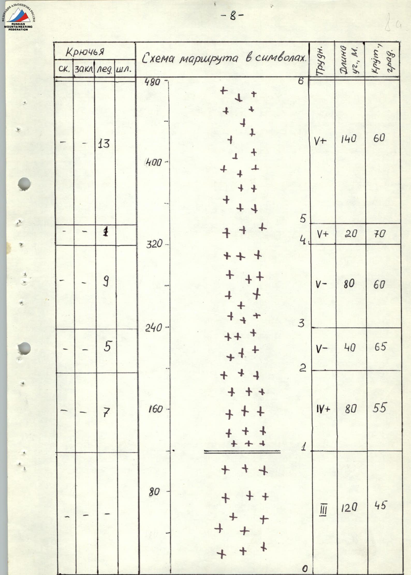
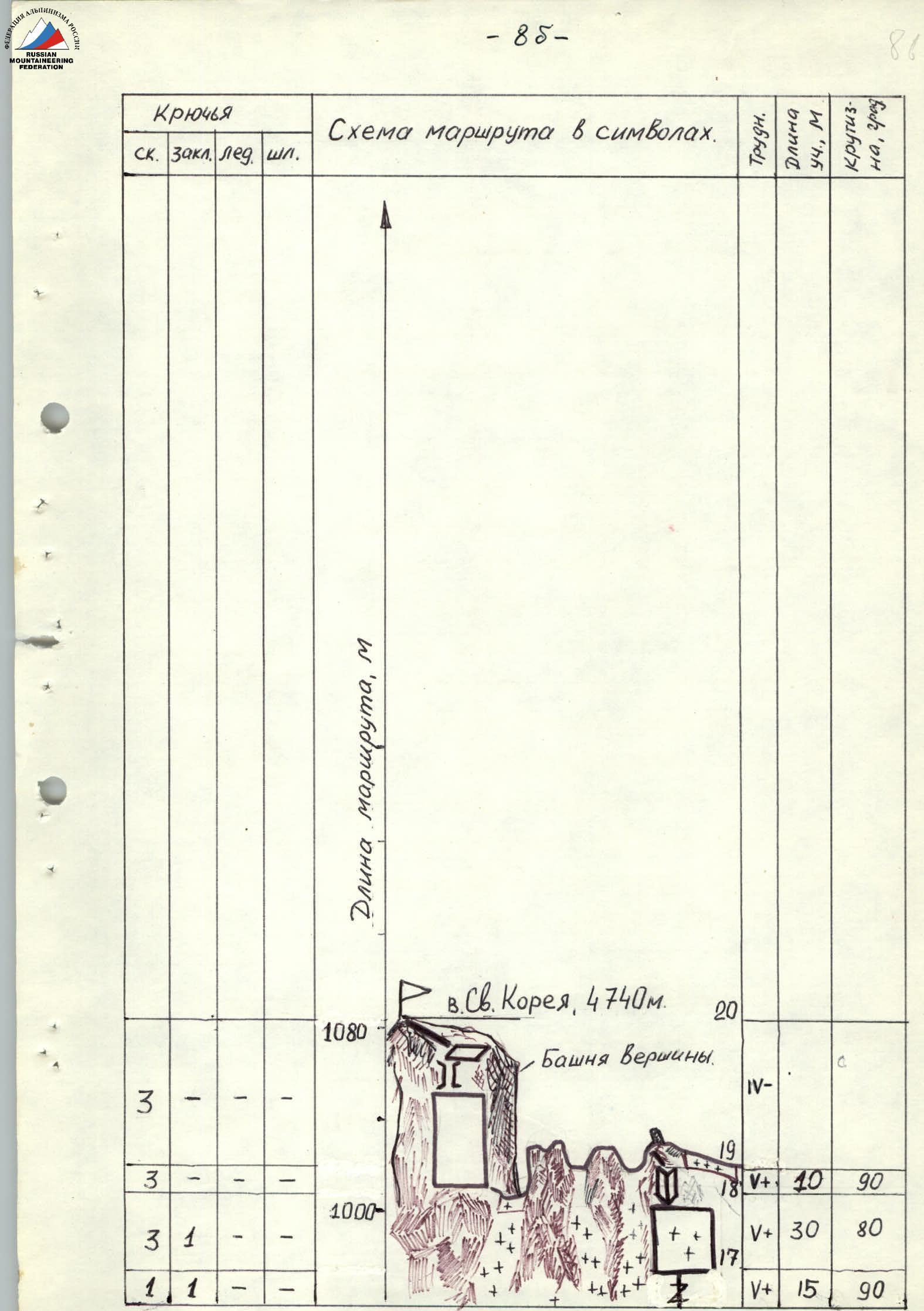
Route Diagram
| Section | Rock | Nuts | Ice | Bolt | Cat. diff. | Section length, m | Steepness, deg. |
|---|---|---|---|---|---|---|---|
| R0–R1 | - | - | - | - | 3 | 120 | 45 |
| (part of R1–R7) | - | 7 | - | - | 4 | 80 | 55 |
| (part of R1–R7) | - | 5 | - | - | 5 | 40 | 65 |
| (part of R1–R7) | - | 9 | - | - | 5 | 80 | 60 |
| (part of R1–R7) | - | 1 | - | - | 5 | 20 | 70 |
| (part of R1–R7) | - | 13 | - | - | 5 | 140 | 60 |
| R7–R8 | 2 | - | 2 | - | 4 | 60 | 50 |
| R8–R9 | 1 | - | 2 | - | 5 | 20 | 75 |
| R9–R10 | 4 | - | 2 | - | 4 | 100 | 60 |
| R10–R11 | 2 | 1 | 1 | - | 5 | 20 | 75 |
| R11–R12 | 3 | 2 | 1 | - | 5 | 40 | 65 |
| R12–R13 | 5 | 2 | - | - | 4 | 40 | 70 |
| R13–R14 | 4 | 3 | 1 | - | 5 | 40 | 85 |
| R14–R15 | 5 | 2 | - | - | 5 | 40 | 75 |
| R15–R16 | 2 | 2 | 2 | - | 5 | 40 | 70 |
| R16–R17 | 1 | 1 | - | - | 5 | 15 | 90 |
| R17–R18 | 3 | 1 | - | - | 5 | 30 | 80 |
| R18–R19 | 3 | - | - | - | 5 | 10 | 90 |
| R19–R20 (to tower) | 3 | - | - | - | 4 | (length not specified) | (steepness not specified) |
Route Description by Sections
Sections:
- R0–R1: Steep snow slope, increasing in steepness (40–50°), leading to a bergschrund. Slope length 120 m.
- R1–R7: Steep ice slope turning into a wide couloir in its upper part. Slope steepness varies — from 55 to 70°. Length 440 m. In the lower part, the ice is porous and wet. In the upper part — hard, ice screws are difficult to place.
- R7–R8: Ice ridge (80 m), increasing in steepness (average — 50°), leads under a rocky wall, iced over, to the right of the 1st gendarme.
- R8–R9: Rocky wall, iced over, 20 m, steepness 75°.
- R9–R10: Ice ridge, steepness 60°, length 100 m, leads to the second gendarme.
- R10–R11: Rocky wall, iced over, 20 m to the right of the second gendarme. Steepness — 75°.
- R11–R12: After the wall — first up an ice groove, steepness 65°, then up and right along an internal corner, iced over, to a convenient ledge at the top of the third gendarme.
- R12–R13: From the ledge, a rocky wall, heavily destroyed, partially with ice, leads up and left. Wall length 40 m, steepness — 70°.
- R13–R14: The wall turns into a steep (85°) internal corner, also heavily destroyed (20 m). The corner ends with a small ledge. From the ledge, up and left along a steep rocky wall (85°, 20 m). The wall leads under the fourth gendarme.
- R14–R15: Under the gendarme, traverse left. The gendarme is bypassed on the left along the right wall of a rocky-ice couloir. Wall steepness 75°. Rocks are heavily destroyed.
- R15–R16: Above the fourth gendarme, an internal corner, steepness 70°, heavily destroyed, iced over. The corner ends with an icy ledge.
- R16–R17: From the ledge, up a vertical crack 15 m.
- R17–R18: The crack leads to a heavily destroyed, steep rocky wall with ice (30 m, 80°).
- R18–R19: From the wall — to its left exit via a vertical internal corner (10 m) onto the western ridge of Svobodnaya Korea.
- R19–R20: Along a simple ridge (120 m) — approach to the summit tower. Then along steep monolithic rocks (50 m) and a wide 10-meter chimney — exit to the pre-summit ridge. Then 80 m along the ridge — to the summit.