PASSPORT
-
Technical class.
-
Tian-Shan, Kyrgyzsky Ridge.
-
Peak Korona, Fifth Tower, 4860 m via the center of the southwest wall.
-
6A category of difficulty, second ascent.
-
Route characteristics:
- length 980 m
- length of 5–6 category of difficulty 700 m
- average steepness of the route 67°
- average steepness of the main part 75°
-
Pitons hammered:
| rock | nuts | ice screws |
|---|---|---|
| 53 | 115 | 1 |
| 15 | 4 |
-
Climbing hours — 15, days — 3.
-
Night halts:
- 1st — in a tent on a rock shelf,
- 2nd — after the summit on the ridge.
-
Team leader: Timofeev Sergey Vladimirovich — Master of Sports
Team members:
- Tarasov Sergey Kharitonovich — Master of Sports
- Khabibullin Salavat Zagitovich — Master of Sports
- Borisov Sergey Viktorovich — Master of Sports
- Pershin Mikhail Valerievich — Master of Sports
- Starov Vladimir Arnoldovich — Master of Sports
-
Coach: Timofeev Sergey Vladimirovich.
-
Approach to the route — February 20, 1995, Summit — February 22, 1995, Return — February 23, 1995.
-
Organization: Sverdlovsk Regional Sports Committee.
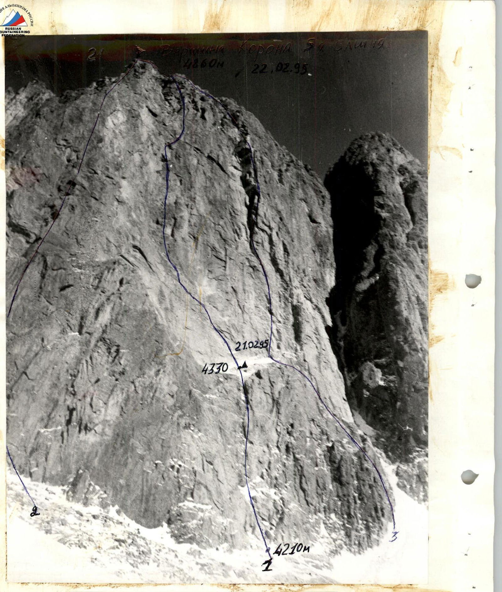
Photo 1. General photo of the summit. Shot point 1. 1 — team route, 2 — Sadovsky's route, 3 — Ruzhevsky's route. Taken on February 19, 1995. Camera "Smena" (F=35 mm). Time — 11:30. Height — 4100 m. Distance — 1 km.
Tactical Actions of the Team
The team's movement on the route was carried out in accordance with the tactical plan. The route was completed in 3 days, along with 1 day of processing. There was one night halt on the route and another after the summit. The tactics were built taking into account the short daylight hours and maximum possible processing to avoid uncomfortable night halts in winter conditions. The route is a rock wall 900 m long with a series of walls, internal corners, cornices, and small ledges. There is only one large ledge on the route, 140 m from the start. The wall section of the route was traversed primarily by free climbing. In some areas, the use of artificial technical means (ITO) was required. The remaining participants moved along the fixed rope using jumars without pulling their backpacks (backpacks were attached to the participant's belay system via a self-belay). The lead climber worked with a double rope, one of which was UIAA, without a backpack. Movement along the fixed rope was done with top or bottom belay.
Weather conditions allowed the team to execute the tactical plan precisely. The successful execution of the tactical plan was facilitated by the team's high physical, technical, and psychological preparation, as well as the tested and refined tactics of movement from previous Russian championships. The 80-meter ridge to the summit was traversed with simultaneous self-belay by independent teams and did not present significant technical difficulties.
Hot meals were provided on the route in the morning and evening; each participant had a pocket snack during the day.
Night halts were organized in safe locations (one on the edge of a large ledge, the second on the ridge after the summit).
The route was left clean; all pitons were removed. Communication was constant.
The route fully matched the developed tactical plan.
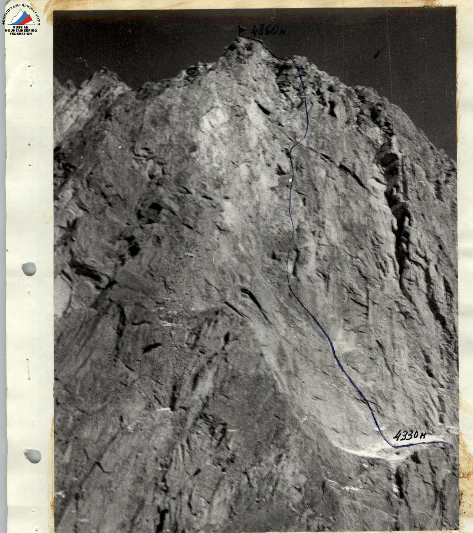
Photo 2. Profile of the left wall. Shot point 2. Taken on February 19, 1995. Camera "Smena" (F=35 mm). Time — 12:00. Height of the shot point — 4200 m. Distance — 1 km.
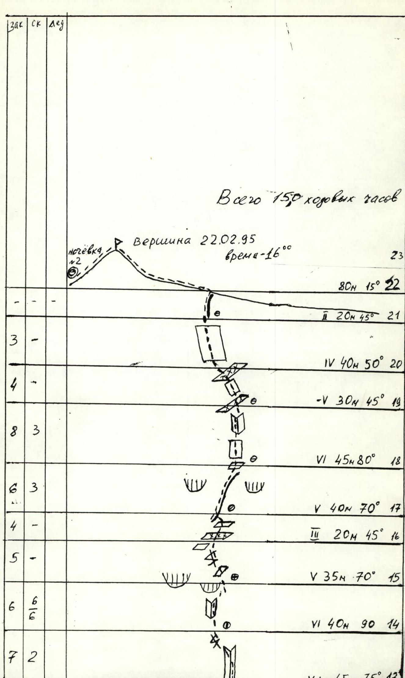
Route Description by Sections
R0–3. Rocks V, V+ category of difficulty, series of walls and internal corners. Traversed by free climbing to the right of a small couloir-gully. R3–4. Large inclined ledge with snow and ice. A good platform was hacked out on the edge. R4–5. Up the wall, traverse left under the cornice — to the base of a large internal corner. R5–6. Exit from the internal corner left through an overhanging wall to a sloping ledge. Very difficult climbing with the use of ITO. R6–9. Series of walls, cracks, and internal corners. Strenuous climbing, sometimes ITO. R9–10. Left along the chimney under the cornices. R10–12. Series of walls and internal corners next to cornices. R12–13. Very difficult 20 m traverse to the right. No holds, no cracks. Traversed on friction. R13–16. Series of internal corners, walls, and cracks bypassing large cornices on the right. Very strenuous climbing, sometimes ITO. R16–17. Several small snow-covered ledges, possible night halt. R17–19. 40 m "well" type section, followed by walls. Climbing is difficult. R19–21. Series of inclined sloping ledges and walls. R21–22. Broken rocks — exit to the ridge. R22–23. Sharp ridge to the summit.