Ascent Passport
-
Region — Tian-Shan, Kyrgyz Ala-Too, 7.4
-
Object — Peak Korona – 5th tower, 4860 m, via SW wall
-
Complexity category — 5B
-
Route type — combined
-
Route characteristics:
height difference — 910 m; route length — 1040 m; length of 6th cat. diff. sections — 35 m, 5th cat. diff. — 230 m; average steepness of the route — 62°; pitons left on the route (own) — 0; pitons used on the route:
- stationary bolt pitons — 2
- removable bolt pitons — 0; total ITO used — 4
-
Number of travel hours — 19 h, days — 2
-
Leader — Sergey Valeryevich Kulygin, 1st sports category
Participants:
- Evgeny Aleksandrovich Rozhnov, CMS
- Niyaz Mirgaziyamovich Khusainov, CMS
Team coach — Valery Sergeyevich Kudryashov, CMS, 1st sports category
-
Route start — August 16, 2006 at 6:00
Return to Base Camp — August 17, 2006 at 18:00
-
Organization: Ministry of Youth, Sports and Tourism of the Republic of Tatarstan
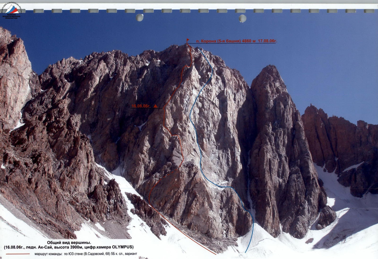
General view of the summit (August 16, 2006, Ak-Sai glacier, altitude 3900 m, OLYMPUS digital camera)
Team's route:
- via SW wall (V. Sadovsky, 1968) 5B cat. diff.
- variation via W wall (V. Egorov) 5A cat. diff.
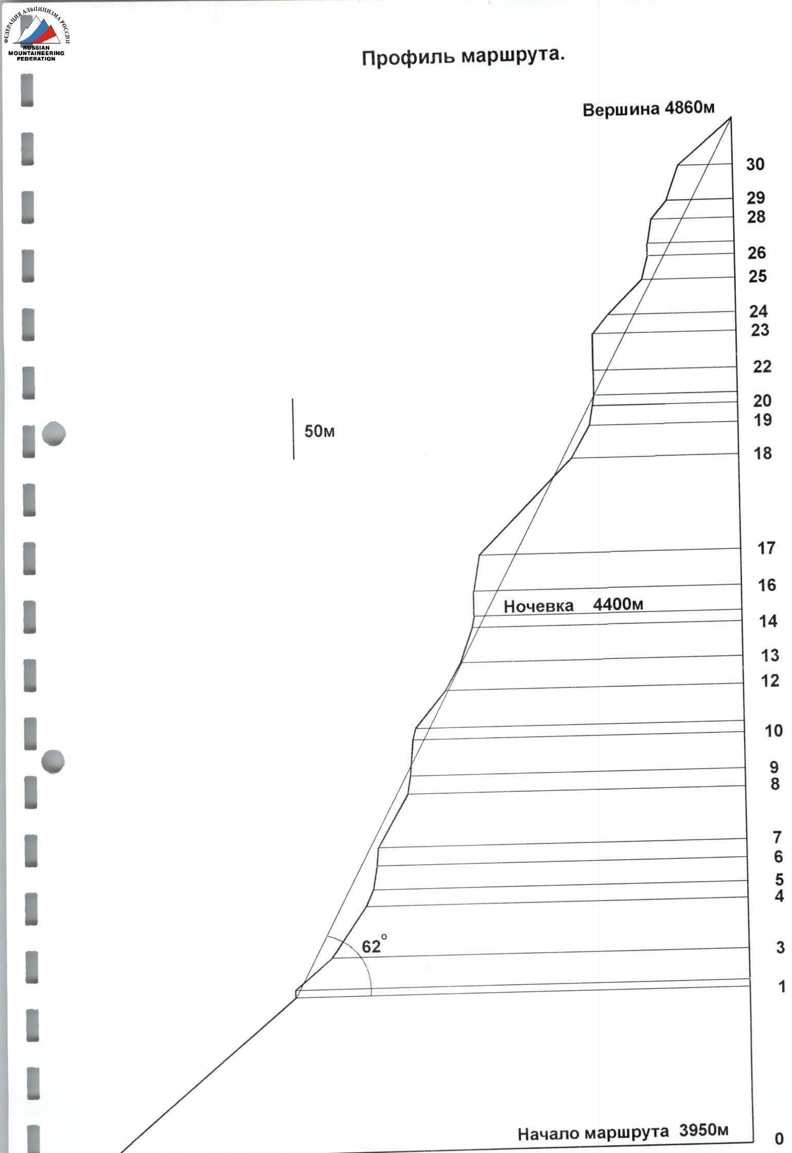
Route profile.
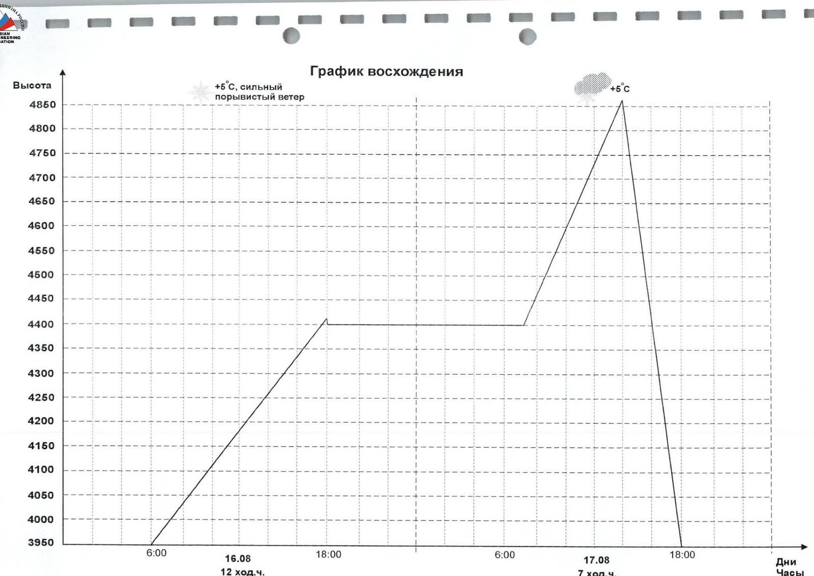
Ascent Schedule
+5°C, strong gusty wind. UIAA route diagram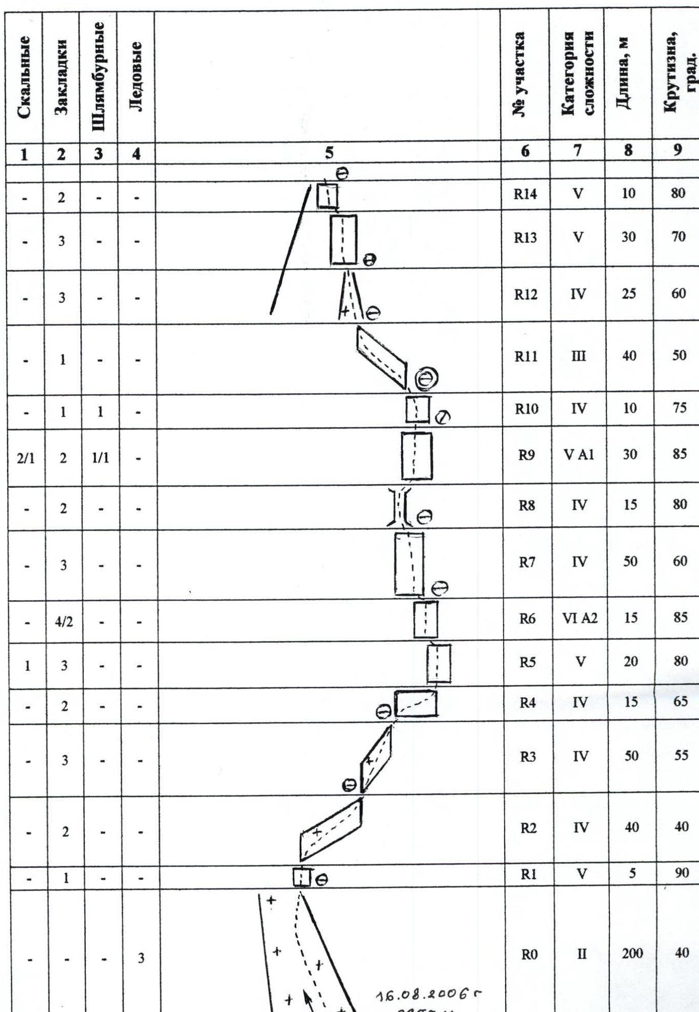
| Rock | Chocks | Bolts | Ice screws | Description / Notes | Section # | Cat. diff. | Length, m | Steepness, ° |
|---|---|---|---|---|---|---|---|---|
| 7 travel hours. August 17, 2006, summit 14:00 | ||||||||
| — | — | — | — | R30 | 3 | 60 m | 40° | |
| — | 2 | — | — | R29 | 4 | 30 m | 70° | |
| — | 1 | — | — | R28 | 4 | 20 m | 50° | |
| — | 2 | — | — | R27 | 4 | 20 m | 80° | |
| — | 2 | — | — | R26 | 5 | 10 m | 90° | |
| 2 | 3 | — | — | R25 | 5 | 20 m | 75° | |
| — | 1 | — | — | R24 | 4 | 40 m | 45° | |
| — | 1 | — | — | R23 | 4 | 20 m | 50° | |
| 2 | 6 | — | — | R22 | 5 | 30 m | 90° | |
| 2/1 | 8/3 | — | — | R21 | 6 | 20 m | 90° | |
| — | 1 | — | — | R20 | 5 | 10 m | 80° | |
| — | 5 | — | — | R19 | 5 | 15 m | 80° | |
| — | 3 | — | — | R18 | 4 | 30 m | 60° | |
| — | 1 | — | — | R17 | 4 | 110 m | 45° | |
| — | 3 | — | — | R16 | 5 | 30 m | 80° | |
| — | 3 | — | — | R15 | 5 | 20 m | 90° | |
| 2 | 4 | — | 1 | August 16, 2006, 12 travel hours + (3) | R* | — | 20 m | 80° |
| — | 2 | — | — | R14 | 5 | 10 m | 80° | |
| — | 3 | — | — | R13 | 5 | 30 m | 70° | |
| — | 3 | — | — | R12 | 4 | 25 m | 60° | |
| — | 1 | — | — | R11 | 3 | 40 m | 50° | |
| — | 1 | 1 | — | R10 | 4 | 10 m | 75° | |
| 2/1 | 2 | 1/1 | — | R9 | 5 | 30 m | 85° | |
| — | 2 | — | — | R8 | 4 | 15 m | 80° | |
| — | 3 | — | — | R7 | 4 | 50 m | 60° | |
| 4/2 | — | — | — | R6 | 6 | 15 m | 85° | |
| 1 | 3 | — | — | R5 | 5 | 20 m | 80° | |
| — | 2 | — | — | R4 | 4 | 15 m | 65° | |
| — | 3 | — | — | R3 | 4 | 50 m | 55° | |
| — | 2 | — | — | R2 | 4 | 40 m | 40° | |
| — | 1 | — | — | R1 | 5 | 5 m | 90° | |
| — | — | 3 | — | R0 | 2 | 200 m | 40° |
Technical photograph of the route.
Route description by sections
August 16, 2006. Departure from base camp to Korona overnight stays at 4:30. We start the route at 6:00.
Section R0 is traversed in crampons simultaneously, with ice screw protection.
Upon reaching the rocks, there is a vertical wall (R1).
Sections R2 and R3 represent an oblique inclined shelf. We proceed with alternate protection using chocks and protrusions.
Sections R4–R6 are a monolithic wall, becoming increasingly complex upwards. Initially, we traverse to the right, then directly upwards. On the last section (R6), we are forced to use ITO on chocks.
Section R7 has a similar character, but is "lying" (60°). Sections R8 and R9 represent a somewhat indistinct chimney, partially wet and dirty. Higher up, it transitions into a smooth wall where we again use ladders. The ropes (50 m) are insufficient to reach the next platform, so the belay position is inconvenient.
We pass the remaining part of the wall (R10). Then, we traverse left along a simple shelf for a full rope length. Here, it is possible to establish an overnight stay.
From the end of the shelf, a steep, destroyed couloir (R12) leads left and upwards, transitioning into similarly destroyed rocks (R13). At the end, before reaching the ridge, there is a sheer wall.
On the left side of the ridge, 20 m below, there is a platform for a bivouac, where we set up an overnight stay in a tent (section R*).
August 17, 2006. Departure at 7:00. We ascend to the ridge via fixed ropes, which then transitions into a sheer wall (R15). Further on, an internal angle begins, with smoothed rocks (R16), transitioning into a couloir — many loose rocks! The couloir gradually turns into a wall (R18 and R19), with a chimney at the end, fortunately dry.
The route continues left of the chimney, about half a rope length — a chimney with a "cork" (R21). Climbing is complex, partially on ITO. We reach a convenient spot for an overnight stay under an overhang.
The overhang is circumvented to the right via a sheer but climbable wall (R22), leading to a ridge section (R24). At the end of the ridge, there is another spot for an overnight stay.
Then, the final complex section begins (R25–R27), particularly the internal angle in the middle — strongly inclined to the right.
Further on, there are possible variations for reaching the summit. It is preferable to move right and upwards along a wide, oblique shelf (R28), then upwards via simple rocks to the pre-summit slope. We reach the summit at 14:00.
Descent is via the 3rd ridge to the saddle between the 2nd and 3rd towers of Korona (two sports descents along the way). Then, a 50 m rappel to the left onto the Korona glacier.