Report
On the ascent of peak "Kyrgyzstan" via the North face (claimed to be the first Soviet ascent of technically complex class).
And on the traverse of peak "Kyrgyzstan" with ascent via the North face (claimed to be the first ascent by the Central Council of the Spartak DSO).
Alma-Ata, 1963
I. Introduction
The combined team of the Kazakh Republican Council of the Spartak DSO:
- July 5–8, 1963, ascended peak "Kyrgyzstan" via the North face, claimed to be the first Soviet ascent of technically complex class.
- July 1–3, traversed the peak with ascent via the North face.
Peak "Kyrgyzstan" is located in the upper reaches of the Salyk glacier in the Alamedin gorge, central part of the Kyrgyz Alatau range (see the schematic of the Kyrgyz Alatau) in the area of the Alamedin walls, very popular among climbers of Kyrgyzstan and Kazakhstan. The absolute height of the peak is 4840 m, making it the highest point of the latitudinal part of the Alamedin spur.
The peak has four ridges: Northwest, Southwest, Southeast, and Northeast.
- The Northwest ridge is a combined ice-snow-rock ridge, sharp, of moderate difficulty to overcome.
- The Southwest and Southeast ridges were not studied in detail by us (they are only visible from the Pastukhov glacier). The visible sections of the ridges are of moderate difficulty, sharp, and ice-rock-snow.
- The Northeast ridge is the most difficult to traverse, sharp, steep, icy with rare outcrops of difficult and medium rocks. The ascent via this ridge by Leningrad climbers (Kheysin group) is considered an ascent of the highest complexity category.
From peak "Kyrgyzstan", the Pastukhov glacier descends to the south, the Jhumgol-Protsenko glacier to the east, a small Nameless glacier to the west, and a large Salyk-Western glacier to the north.
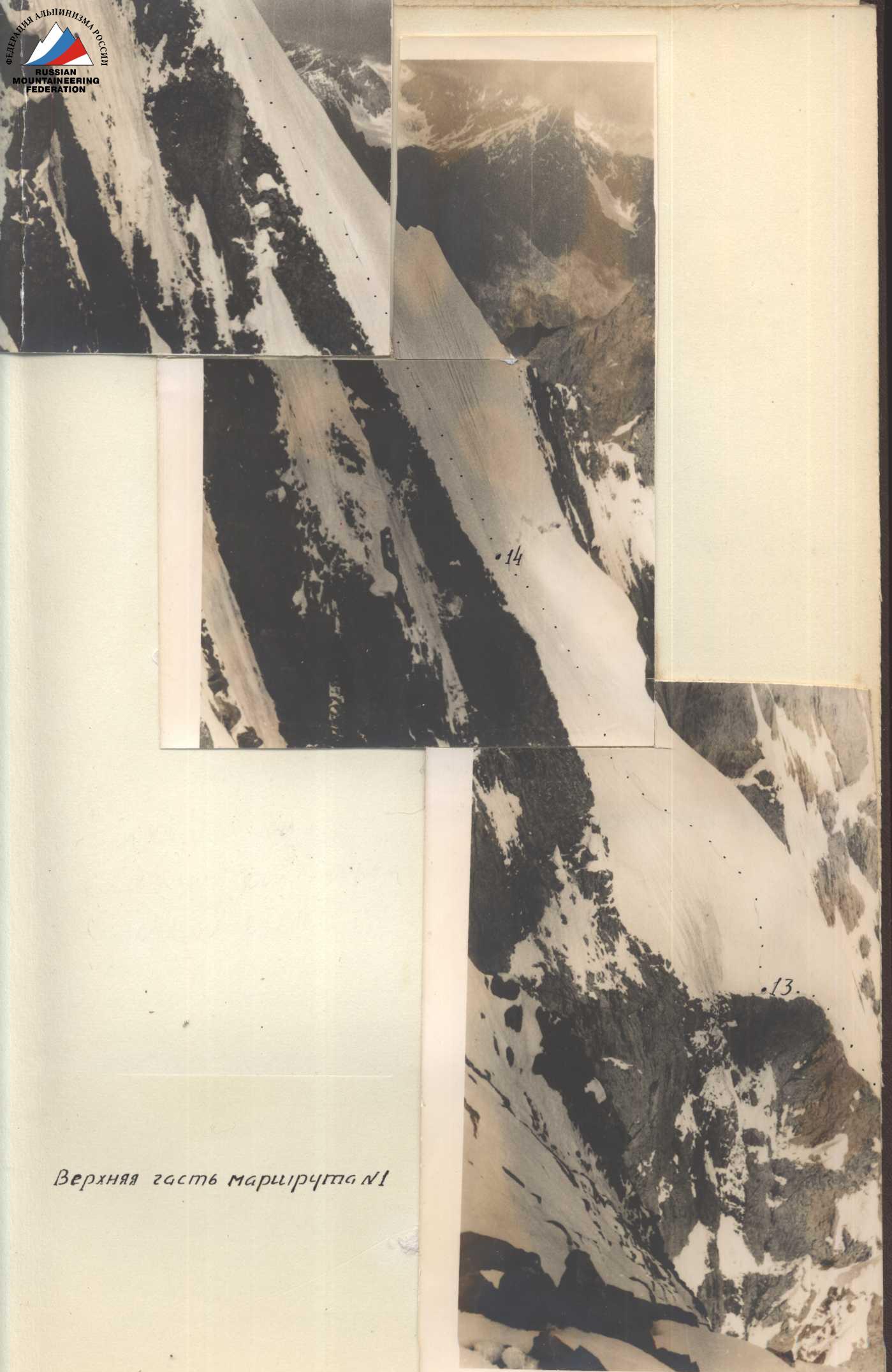
To the north, peak "Kyrgyzstan" drops off into the Salyk-Western glacier with an almost sheer, over a kilometer high, ice-rock wall, which was the dream of our team (and not just ours) for several years. The relative height of the wall above the upper reaches of the glacier is 1100 m.
This area has only recently begun to attract climbers, as the technique of mountaineering has significantly advanced, making ascents possible that were previously unimaginable.
Kazakhstan climbers have only recently begun to undertake technically very complex ascents. By 1960, we had completed all the complex routes in the Trans-Ili Alatau that had been done earlier by strong teams from Moscow, Leningrad, etc., and we began to prepare for "our own" routes.
By 1961, the Spartak team, which formed the core of the Kazakhstan national team, had become strong enough to ascend the North face of peak Svobodnaya Koreya and the West face of peak Bai-Iyan-Bashi.
In 1962, the team did not conduct an independent event due to the illness of its captain. However, some team members made remarkable ascents:
- to peak Khan Tengri;
- West face of peak Mayakovsky;
- West faces of peak Talgar and others.
By 1963, many complex wall routes had been completed in the Kyrgyz Alatau:
- North face of peak Svobodnaya Koreya;
- Korona;
- Bai-Iyan-Bashi and others.
as well as traverses:
- Aksay podkova;
- Tr. Alamedin walls and others,
which had long been considered beyond the capabilities of even very strong teams.
In 1963, the time had come to ascend the almost sheer, cold, and imposing North face of peak "Kyrgyzstan".
Preparation for the Ascent
Preparation for such a serious ascent began as early as 1961, and by the summer season of 1962, the team was ready to head to the area. Our application was approved, but a series of unfortunate circumstances forced us to postpone the assault on the wall for a whole year.
From the autumn of 1962, the team began to seriously prepare light, reliable, and convenient equipment. We started with metal equipment: by the summer season, we had two lightweight (0.4 kg) platforms that had passed the most rigorous tests; we manufactured small (1.5 to 5 m) well-spliced ladders and two 30 m ladders, as well as:
- piton hooks made of steel and duralumin with good technical characteristics;
- petal and regular titanium hooks, channel hooks;
- anchor, corkscrew, and other ice hooks made of steel and light alloys;
- "eternal" piton hooks;
- hook catchers and others.
This metal equipment allowed us to confidently traverse the wall. Only the "eternal" piton hooks produced by the All-Union Central Council of Trade Unions failed to justify themselves - they had a very small wedge.
The rest of the equipment was already available to the team, except for six sleeping bags, which were first received by the team on the day of departure.
We also seriously approached the issue of nutrition on the wall. This task was entrusted to a group led by G. Petraško (see below). As a result, the group on the wall was provided with:
- calorie-rich;
- well-tolerated at high altitudes;
- tasty and
- lightweight products.
The main team composition trained year-round as part of the Kazakhstan national team. Special training in rock and ice technique began in March of this year, when nearby rocks were free of snow. By the start of the season, all team members were confidently overcoming:
- smooth overhangs;
- нависы (using and testing all our equipment).
Steep ice walls (up to 10 m) are also available 15–17 km from Almaty until mid-April, allowing for full-fledged training without leaving production.
On the approach
Conditions for the Ascent of peak "Kyrgyzstan"
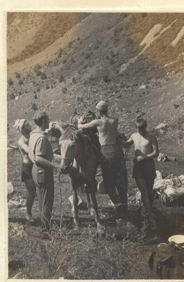
Peak "Kyrgyzstan" is located 50 km from the capital of the Kyrgyz SSR, Frunze (30 km by car, 15 km on horseback, 5 km on foot).
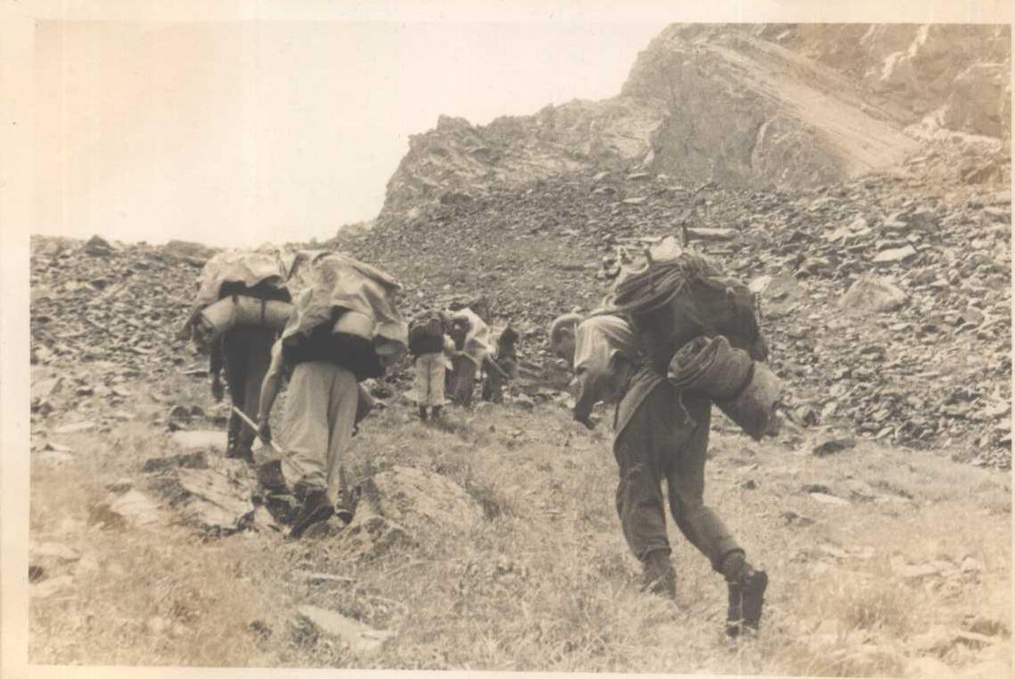
To get to Tash-Moynek village, there is a good road, and buses run daily. Further (orographically) along the right bank of the Alamedinka river, along a satisfactory dirt road to the Salyk river (2 km) and then along the right bank of the Salyk river (4 km) to the terminal moraine, it is easy to reach with the help of pack animals. Another 5 km on foot along the terminal and lateral moraines of the Salyk river, and you are at the foot of peak "Kyrgyzstan".
Tash-Moynek village is the last settlement with some communication links (telephone, telegraph). In the neighboring gorge to the west is the Ala-Archa mountaineering camp.
Despite good accessibility, the upper reaches of the Salyk glacier are still poorly explored by climbers. In 1952, a group led by Marechek first ascended peak "Kyrgyzstan" from the Pastukhov glacier area.
In 1961, an expedition led by A. Romanov ascended peak "XXII Party Congress" with a complexity category of 4B. In 1962, a group from Leningrad's "Trud" (led by Kheysin) traversed peaks "Kyrgyzstan" and "XX Party Congress", claiming it as a first Soviet ascent (2nd place).
Several ascents of easier routes were made to the peaks of the Salyk glacier circus from neighboring gorges. This concludes the list of known ascents.
Weather conditions in the Salyk glacier area are typical for the entire Northern and Western Tian Shan. During the team's stay in the area, there were:
- 6 days without precipitation;
- one thunderstorm with sleet;
- several instances of light snow.
As a rule, after 3–4 pm, fogs typically form. At night and in the morning, the weather is usually excellent.
Route Reconnaissance
To preliminarily select the ascent object, in 1961, we sent a group consisting of:
- Master of Sports V.P. Fedchenko;
- 1st Category Sportsman E.I. Skuratovich,
to the upper reaches of the Salyk glacier. The group reconnoitered the approaches and recommended route options. In the autumn of 1961, at a team meeting, the ascent object was approved.
Over three days (June 28–30, 1963), the team leadership thoroughly studied the North face, noting hazardous and difficult sections. To clarify some questions, we traversed peak "Kyrgyzstan" with an ascent via a weakly expressed counterfort (see the schematic). This ascent was claimed for the first prize of the Central Council of the Spartak DSO and was completed in 3 days (42 continuous working hours) by a group consisting of:
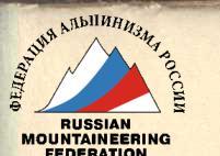
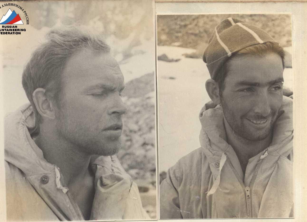
- B.A. Studenin - Master of Sports - leader;
- I.G. Domianidi - Master of Sports;
- G.A. Petraško - 1st Category Sportsman;
- V.P. Reznik - 1st Category Sportsman.
Organization and Tactics of the Ascent
The All-Union Federation accepted our application for the ascent of peak "Kyrgyzstan" via the North face with a team consisting of:
- B.A. Studenin - leader;
- I.G. Domianidi;
- G.I. Fedotov;
- G.A. Petraško;
- V.P. Reznik;
- E.I. Skuratovich;
- M.S. Kulemin (reserve).
To complete the ascent, a group of 12 people was sent to the Salyk glacier area:
- Masters of Sports: Studenin, Domianidi, Fedotov, Kulemin;
- 1st Category Sportsmen: Petraško G.A., Reznik V.P., Savin, Garshin, Ermilova;
- 2nd Category Sportsman: Sverdlina;
- 3rd Category Sportsman: Sagimbekov (doctor) and Povoroznyuk.
According to the plan:
- The main ascent was to be carried out by: Studenin, Domianidi, Petraško, Reznik.
- The backup group consisted of: Kulemin, Fedotov, Savin, Garshin.
- The auxiliary group, which ensured observation of the climbers and reliable communication with the USSR Federation, Central Council of the Spartak DSO, and other organizations, consisted of: Ermilova, Sverdlina, Sagimbekov, and Povoroznyuk.
The route sheet and calendar plan were approved by the authorized representative of the USSR Alpine Federation, D.I. Gushchin, and other team materials were agreed upon.
After a thorough reconnaissance of the route, we outlined the following plan for traversing the wall:
- Early morning on July 5 - departure of the assault quartet on the route, with the aim of reaching the safe rocks by 11:00 (start of rockfall and avalanches).
- Movement in two equal pairs with three backpacks (the first participant always goes without a backpack).
- Traversing particularly complex sections with the help of a 30-meter ladder.
- Completing the route with three nights on the wall.
- Provisions and fuel taken for 6 days, considering possible bad weather.
- Backpacks to be pulled up using an auxiliary rope.
- The number of participants reduced to four to ensure safety.
No significant changes were made to these plans during the ascent.
During the ascent, the 30-meter lightweight nylon-duralumin ladders, petal hooks, and hammers with reinforced "beaks" that we had not used before fully justified themselves.
The entire team on the wall acted in harmony, at a good pace. The good physical and technical preparation of the participants allowed us to maintain the pace throughout the ascent.
Medical Support
Team members are under constant supervision by the Republican Sports Medicine Dispensary. Every 6 months, all participants undergo a full medical commission, and before each ascent, a medical examination is conducted.
Before departing for the Kyrgyz Alatau, the team underwent a full medical commission. All team members were healthy.
In the base camp, Dr. Sagimbekov U. was constantly present, who:
- conducted medical examinations;
- provided consultations before ascents;
- monitored the quality of food, its composition, calorie content, and vitamin saturation.
Throughout the stay in the mountains, there were no cases of injury or colds.
Studenin B.A., Petraško G.A.
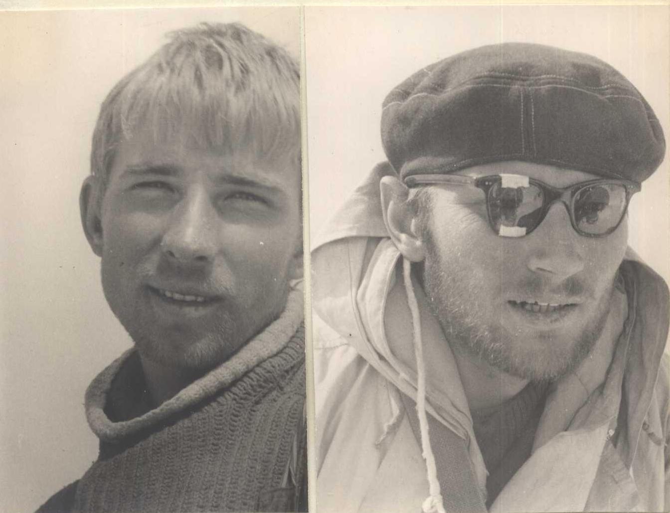
Description #1 (Traverse of peak "Kyrgyzstan" from West to North with ascent via the North face)
I. Day. Departure at 3:00 (exit at 3:30). From the base camp on the left moraine of the Salyk glacier, we move southward to the base of the counterfort of the Central Alamedin wall; then, skirting the crevasses of the glacier tongue, we move southeast, ascending to the Bergschrund under the West counterfort of the North face of Kyrgyzstan. The journey from the camp to the start of the ascent takes 1.5 hours.
Section R1
We ascend the avalanche cone to the Bergschrund, with a slope of 45°–50°; hard-packed snow, steps are easily kicked in, insurance via ice axe; length - 70 m.
Section R2
We cross the Bergschrund via a snow bridge formed by avalanches. The slope steepens to 60°. The snow slope turns into an ice slope, requiring step-cutting. The length from the Bergschrund to the rocky outcrops is 40 m, with 3 ice hooks driven.
Section R3
This section is a rocky island 80 m long, with an overall slope of 50°–45°. The rocks are smoothed, tile-like, of medium difficulty, requiring piton insurance. 6 hooks were driven, and outcrops were used.
Section R4
From the upper part of the rocky island, with careful piton insurance, we traverse westward across the ice couloir separating the island from the main wall. The couloir is 15 m wide, with polished ice, hard, and steps are difficult to cut into. It is difficult for standard ice hooks to enter; titanium channel hooks 20–25 cm long enter and hold well. 2 rock hooks and 1 ice hook (channel) were driven.
Section R5
After crossing to the rocks, we traverse 10 m to the right across difficult rocks, driving 2 hooks. Then, we ascend 30 m up difficult rocks with a slope of 75°–80°. 4 titanium hooks and 1 channel hook were driven. The rocks are smooth, with few holds and cracks.
Section R6
The wall gradually transitions into a poorly defined internal angle with a slope of 60°. The rocks are of medium difficulty, smoothed, with indistinct steps. The length of this section is 70 m. In the upper part, the internal angle turns into a sheer chimney 5 m long, overhanging at the top; 7 hooks were driven on this section.
Section R7
From the chimney, the path goes right of the main counterfort up the "chicken breast"; on the left, it is separated from the counterfort by an ice dome 3 m wide, and on the right, it is bounded by a snow-ice slope. The length of the rocky section is 50 m, with a slope of 60°–70°. The rocks are very smooth, with few holds, and some sections have натёчный лёд (ice formed from melting snow). 8 hooks were driven.
Section R8
From the end of the "chicken breast", we ascend a snow-covered ice slope 10 m long with a slope of 55°. To the right, we approach the base of a rocky wall cut by a chimney filled with натёчный лёд. Steps are cut into the ice, with insurance via 1 ice hook and 2 rock hooks.
Section R9
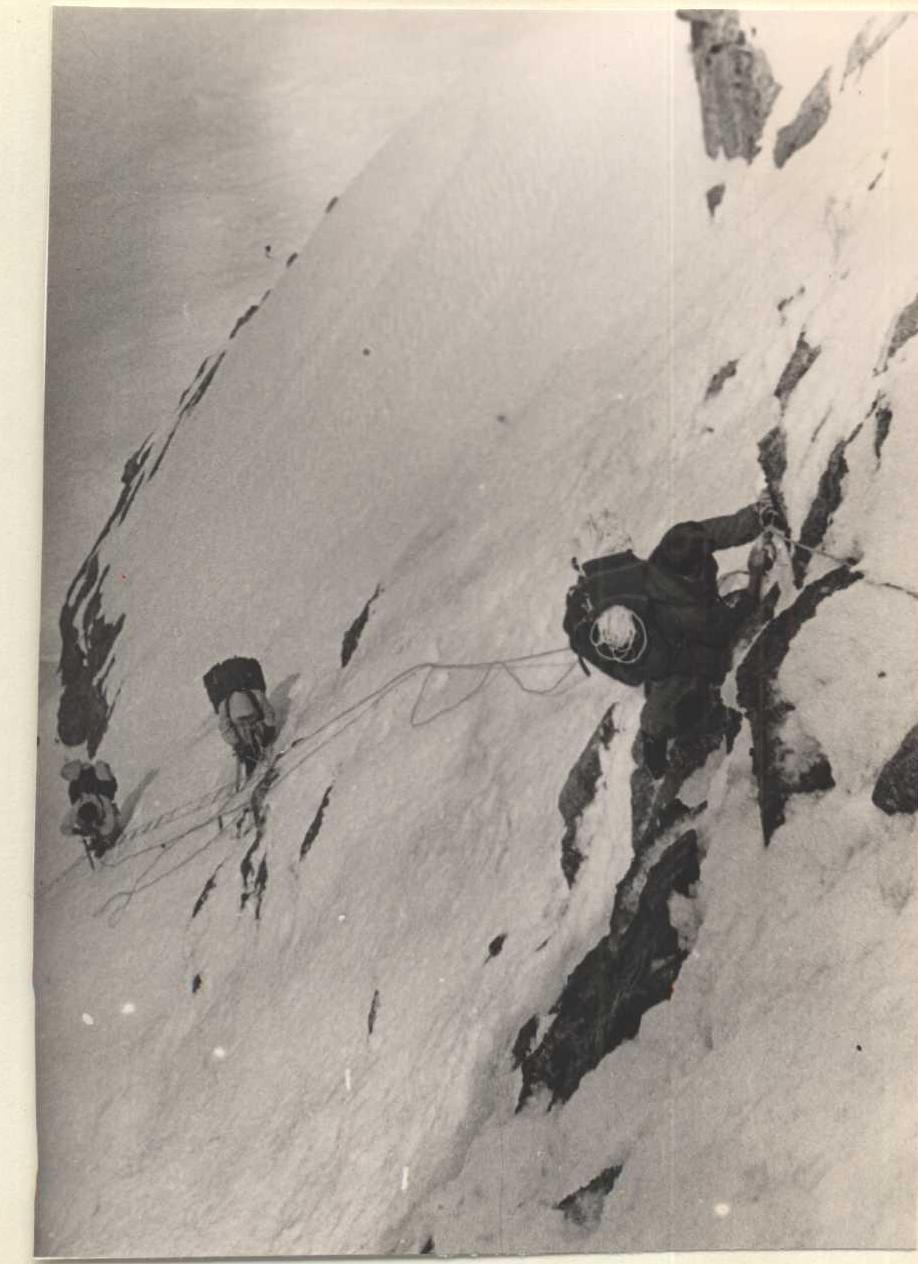
The key section of the route is a non-deep chimney cutting through the entire wall almost to its upper part; the rocks are heavily destroyed, with many "living stones". The chimney is filled with snow and натёчный лёд, with water seeping through it. On either side of the chimney are sheer rocky walls. The width of the chimney is 1.5–2.4 m. The ascent is made along the right wall of the chimney, with a slope of about 90°, and some overhanging sections. The first 35-meter section has 2 overhanging sections, each 4–5 m long, which are traversed using ladders. Sometimes, hooks were driven to create artificial footholds. A total of 17 hooks were driven on this section: 5 petal hooks, 3 titanium channels, 2 wooden wedges, and 7 regular hooks.
Section R10
The path continues up a stepped rocky wall with a slope of about 80°. The wall is tile-like in some places; from a distance, it appears несложной (not complicated), but the smoothed holds make it very challenging. We ascend 120 m straight up, then move right and up 10 m to a small ledge with good outcrops. This section requires extensive piton insurance, with 15 hooks driven.
Section R11
From the ledge, we ascend straight up, then along a smooth плита (slab) 15 m long with rare holds. To the right, another smooth плита overhangs, and to the left, it forms a sharp edge with the first плита. In the upper part, the плита curves slightly to the right, and the right плита overhangs, forming a narrow щель (crevice) that is difficult to squeeze through with backpacks. The slope of this section is 85°. 5 hooks were driven.
Section R12
We encounter another stepped wall similar to Section R10, with a slope of 80° and a length of 50 m. 6 hooks were driven. Here, two counterforts converge: the left one, along which the route goes, and the right one, initially 100 m away from the left.
Section R13
From the convergence point of the counterforts, a rock-snow ridge extends leftward and upward, with a slope of 20° and a length of 60 m. The rocks on the ridge overhang to the left, forming a 200–250 m high sheer wall down to the glacier, creating a своеобразный скальный карниз (rocky cornice), and above the rocks, a snow cornice overhangs, forming a narrow щель (crevice) or полка (ledge) that must be traversed almost crawling.
Insurance is provided through outcrops, and upon reaching the cornice and in the middle of the ridge, 2 hooks were driven.
Section R14
From the rocky cornice, we exit onto a snow подушка (cushion) with a slope of 10°–20° and approach the left edge of the Bergschrund. On the подушка, a good bivouac can be organized if needed.
Section R15
We traverse the Bergschrund to the left and exit onto a weakly expressed snow ridge. To the left of this ridge is a rather difficult and dangerous гребень (ridge) composed of heavily weathered rocks. In the upper part, the steepness of the гребень increases to 70° and transitions into an ice slope lightly dusted with snow, requiring step-cutting. 6 ice hooks were driven.
Upon reaching the watershed гребень, the weather began to deteriorate, and we had to organize a ночёвка (night's stay) in a snow надув (drift). The пещера (cave) was not particularly comfortable but was warm despite the storm raging just above us. The entire night was marked by strong пурга (snowstorm). In the morning, the wind died down somewhat, but снежные "флаги" (snow "flags") still hung over the гребни (ridges).
Section R16
We continue along the snow-rock-ice гребень with numerous "жандармы" (rocky peaks) and snow карнизы (cornices), which are comparatively easily bypassed.
From Section R16 onwards, our route coincides with that of the Leningrad "Trud" group, so we do not provide a detailed description of this part of the route.
The descent from the saddle between peaks "Usechenka" and "Kyrgyzstan" down the ice and ice-snow slope was made using a 100-meter auxiliary rope. The descent was very quick and reliable, with several hooks left in the rare rocky outcrops of the upper part of the slope.
The entire route was completed with light backpacks (without sleeping bags) in 42 working hours, with approximately 20 rock hooks and 11 ice hooks driven (including the descent).
Table of Main Route Characteristics
Route of ascent - North face of peak Kyrgyzstan Height difference of the route 1100 m Including the most complex sections 560 m Steepness of the route 75° Including the most complex sections 85°
| Section | Steepness | Length | Relief Characteristics | Section and Condition Characteristics | Time | Driven Hooks | Bivouac Conditions | Daily Ration Weight |
|---|---|---|---|---|---|---|---|---|
| 1 | 50° | 70 m | Compacted snow | Medium, via ice axe, good | 3:30 | — 3 — | ||
| 2 | 60° | 40 m | Ice, dusted with snow | Medium, ice hooks, good | — — 3 | |||
| 3 | 50° | 80 m | Tile-like rocks | Medium, piton insurance, good | — 6 — | |||
| 4 | 0° | 0 m | Polished ice | Difficult, piton insurance, good | — 2 1 | |||
| 5 | 75–80° | 30 m | Smooth rocks | Difficult, piton insurance, good | 7 — — | |||
| 6 | 60–65° | 70 m | Stepped rocks | Medium, piton insurance, good | 7 — — | |||
| 7 | 65–70° | 50 m | Smooth rocks with натёчный лёд | Difficult, piton insurance, good | 8 — — |
Description of the Ascent via the North Face of peak "Kyrgyzstan"
On July 5, 1963, at 3:30, after eating a hearty homemade meal for the last time, the assault group shouldered three backpacks and headed towards the foot of peak "Kyrgyzstan" along the familiar path. Looking back, we see our comrades remaining in the camp, watching us until we disappear from view, then huddling into their tents. In 1 hour and 20 minutes, we reach the beginning of the difficult part of the route - a steep snow slope leading to the Bergschrund. After a short rest, at 5:00, we check our readiness once more and begin our ascent.
Section R1
We ascend directly up the snow cone to the Bergschrund. The snow slope is 40° steep. Steps are easily kicked in with 2-3 blows of the boot. Insurance is provided via an ice axe; the difficulty is medium.
Section R2
The powerful Bergschrund, 8 m high and almost vertical, is traversed at a point where the avalanche snow has formed a kind of трамплин (trampoline) from the lower edge to the upper. With careful insurance via an ice axe, the first climber ascends using ladders suspended from anchor hooks. At the top, an ice hook is driven, a 30-meter ladder is hung, and the participants ascend with their backpacks. This section is difficult; 1 ice hook and 4 anchor hooks were driven.
Section R3
A long and quite steep (200 m, 60°) ice slope, partially covered with dense, shallow snow. Tamping down steps does not provide sufficient reliability; they need to be cut with an ice axe. Insurance is via an ice axe, partly through ice hooks.
4 standard ice hooks and 1 titanium channel hook were driven.
Section R4
We exit onto the rocks of the first wall to the right of the ice-filled chimney. The rocks are diorite плита (slabs) with a slope of 70°. The плита are smoothed, with few dubious holds and a small number of достаточно широкие трещины (sufficiently wide cracks). Insurance is exclusively via pitons, as there are no good outcrops on the плита; the wall is uniform from top to bottom. If desired, it is easy to pull up backpacks here over a distance of 60–80 m. The length of the wall is approximately 150 m.
21 hooks were driven, including 9 petal titanium hooks and 2 titanium channels.
Section R5
After ascending the right part of the wall, we exit onto an ice-snow slope with individual rock outcrops, separating the first wall from the second. To the left, an ice гребень (ridge) passes, followed by another ice-snow slope leading to simpler rocks on the second wall.
However, this slope is:
- усеян бороздами (strewn with furrows) from falling stones;
- сильно простреливается (heavily exposed to) stones.
Therefore, we decide to go to the right of the ice гребень. The section is traversed with step-cutting and careful piton insurance.
Length: 60 m. Slope: 60°.
Equipment:
- 2 rock hooks driven;
- 4 standard ice hooks;
- 2 titanium channels in ice.
Section R6
The ice-snow slope transitions into smoothed rocks at the base of the 2nd wall, залитые натёчным льдом (covered with ice formed from melting snow). Small icicles hang from the rocks, occasionally falling; the processed ice also falls on those below, which is quite неприятно (unpleasant).
On Section R6
Section R7
We traverse 2 верёвки (ropes) straight up to the base of the sheer, местами нависающая (overhanging in places) wall, then make a difficult траверс (traverse) left and up along the wall. We use 30-meter ladders twice during this section, pulling up backpacks from behind the slope's перегиб (bend) using an auxiliary rope over a distance of 60 m. It takes over 4 hours to overcome 120 m. The обходы (detours) of this difficult and неприятный (unpleasant) section are опасны (dangerous): to the left, as mentioned, is a slope простреливаемый камнями (exposed to falling stones), and to the right is a лавиноопасный кулуар (avalanche-prone couloir). We observed a грандиозная лавина (grand avalanche) descending the кулуар at 12:30, not far from us. Small лавины (avalanches), куски льда (pieces of ice), and камни (stones) almost непрерывно (continuously) fall along it, starting from 10:00–11:00. The slope of this section is 80°.
7 petal titanium hooks, 6 titanium channels into rocks, 2 titanium channel hooks into ice, and 13 standard rock hooks were driven.
After the перегиб (bend), we exit onto an almost horizontal полка (ledge) covered with snow. We decide to stop for the night. 2 hours of work, and the площадка (platform) is ready. The палатка (tent) is hung on hooks, with two people inside and two outside. The night is очень тёплая (very warm).
Before the ночёвка (night's stay), 4 rock hooks were driven. To ensure safety, another 7 hooks were driven.
On August 6, 1963, at 7:00, the дежурный (duty officer) opens the next ration and prepares breakfast. We eat our fill and drink plenty of water. At 8:30:
- The 1st связка (rope team) heads out onto the route;
- The 2nd связка finishes packing up the bivouac.
As we leave, we leave behind the 1st контрольный тур (control cairn).
Section R8
10 m траверс (traverse) along the полка (ledge) that served as our ночёвка (night's stay). We cross a polymetallic жилка (vein) - minerals of меди (copper), свинца (lead), цинка (zinc), and железа (iron) are visible to the naked eye. We approach a навес (overhang). Here, we can спокойно (calmly) sit while the first climber passes the next section. Upward, a sheer wall rises, followed by another полка (ledge), then another wall, and a black, продырявленный (riddled) and пропаханный (plowed) by stones, snow-ice slope. 2 rock hooks were driven.
Section R9
From the полка (ledge), we ascend по отвесным сглаженным скалам (up sheer, smoothed rocks). Initially, we move slightly left, then right and up.
A 30-meter лестница (ladder) is hung, two people climb up, pull up the backpacks, and then the third person climbs.
The length of the wall is 30 m, the slope is 80°, and 7 hooks were driven.
Section R10
We ascend по внутреннему углу (up an internal corner) with a slope of 85° and a length of 40 m to a полка (ledge) where:
- надёжная страховка (reliable insurance) is organized;
- a 30-meter лестница (ladder) is hung;
- backpacks are pulled up.
The rocks are very гладкие (smooth), монолитные (monolithic), with many трещины (cracks) for hooks. 13 hooks were driven, and 3-step лестницы (ladders) were used.
Section R11
From the полка (ledge), we ascend left and up 4 m, then по 6-meter стене (up a 6-meter wall) with good holds to a полка (ledge), then again по стене (up a wall) 6 m high with two нависающие участки (overhanging sections), and finally 6 m по сложным скалам (up complex rocks) to a полка (ledge) formed by отвалившиеся громадные остроугольные обломки диорита (fallen massive, sharp-angled fragments of diorite).
The overall slope of the wall is 75°. 9 rock hooks were driven.
Section R12
Upward from the площадка (platform), an отвесная сверкающая стена (sheer, sparkling wall) rises; to the left of it, a глубокая расщелина (deep crevice) cuts through the wall; behind the расщелина is a гладкая 12-meter стена (smooth 12-meter wall), almost отвесная (sheer). There are no holds at the base; 5 m are traversed using лестницы (ladders).
A 30-meter лестница (ladder) is hung, backpacks are pulled up, and 5 hooks were driven.
We exit onto небольшие полочки (small ledges); to the right, 10 m away, a снежная перемычка (snow saddle) is visible, from which a снежный гребень (snow ridge) leads to an отвесная рыжая скала (sheer, reddish rock). This is the start of the "рыжие стены" (red walls) that грозно высятся (tower menacingly) for approximately the second third of the height of the North face of "Kyrgyzstan".
We ascend to a седловинка (small saddle), leave behind the 2nd контрольный тур (control cairn), and start thinking about ночлег (lodging). On the снежный гребень (snow ridge), it was impossible to set up a площадка (platform) - under the snow was an наледенелый ледовый гребень (iced-over ice ridge) with a slope of up to 50°; the path further was просматривался (visible) for 100–120 m, and nothing утешительного (reassuring) was seen.
We decide to descend to the площадка (platform) under the 12-meter стеной (wall) and set up ночлег (lodging) there. While two people arrange the ночлег, the other two hang a верёвка (rope) over an almost 100-meter участок (section). To organize the ночёвка (night's stay), 5 hooks were driven.
Section R13. July 7, 1963
Departure at 5:30; by 7:00, we are already on the route. We again traverse the 12-meter стену (wall). Then, по заглаженным черепицеобразным плитам (along smoothed, tile-like slabs), we ascend left and up towards the start of the гребешок (ridge) passing left of the "рыжие скалы" (red rocks). After ascending 30–32 m по плитам (along the slabs), we cross a кулуар (couloir) and exit onto the скалы гребешка (rocks of the ridge). The slope is 50°; the length of the section is 40 m. 7 hooks were driven; backpacks were pulled up using верёвки (ropes).
Section R14–R15
The гребень (ridge) steepens, forming a навес (overhang). The ascent is made to the right of the навес по стене (along the wall) with множество "живых камней" (many "living stones"). 4 m are traversed using лестницы (ladders).
The стена (wall) transitions into a заснеженный ледовый склон (snow-covered ice slope), which we traverse to exit onto a скальная полка (rocky ledge), pull up the backpacks, and hang a 30-meter лестница (ladder).
Length: