Route 5A cat. sl., description compiled by Aksenov V.A.
General Information about the Climbing Area
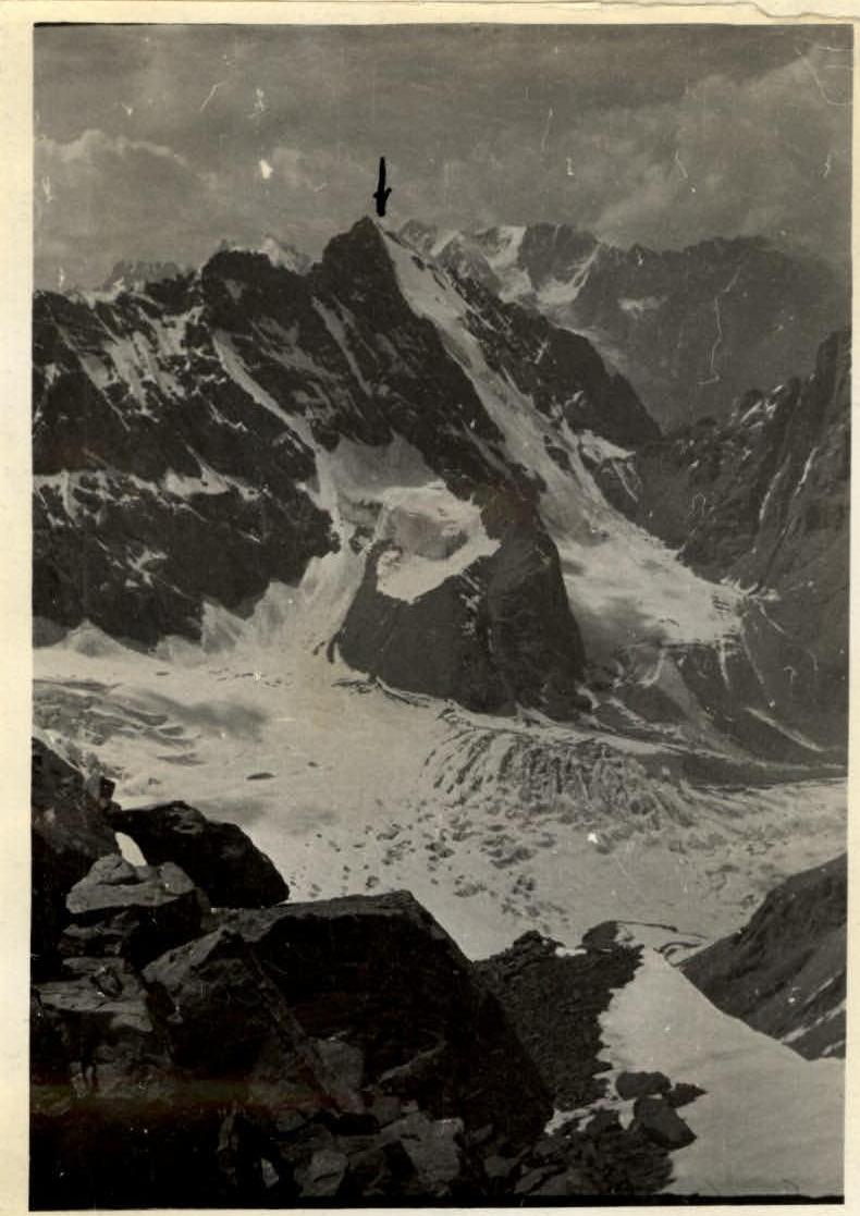
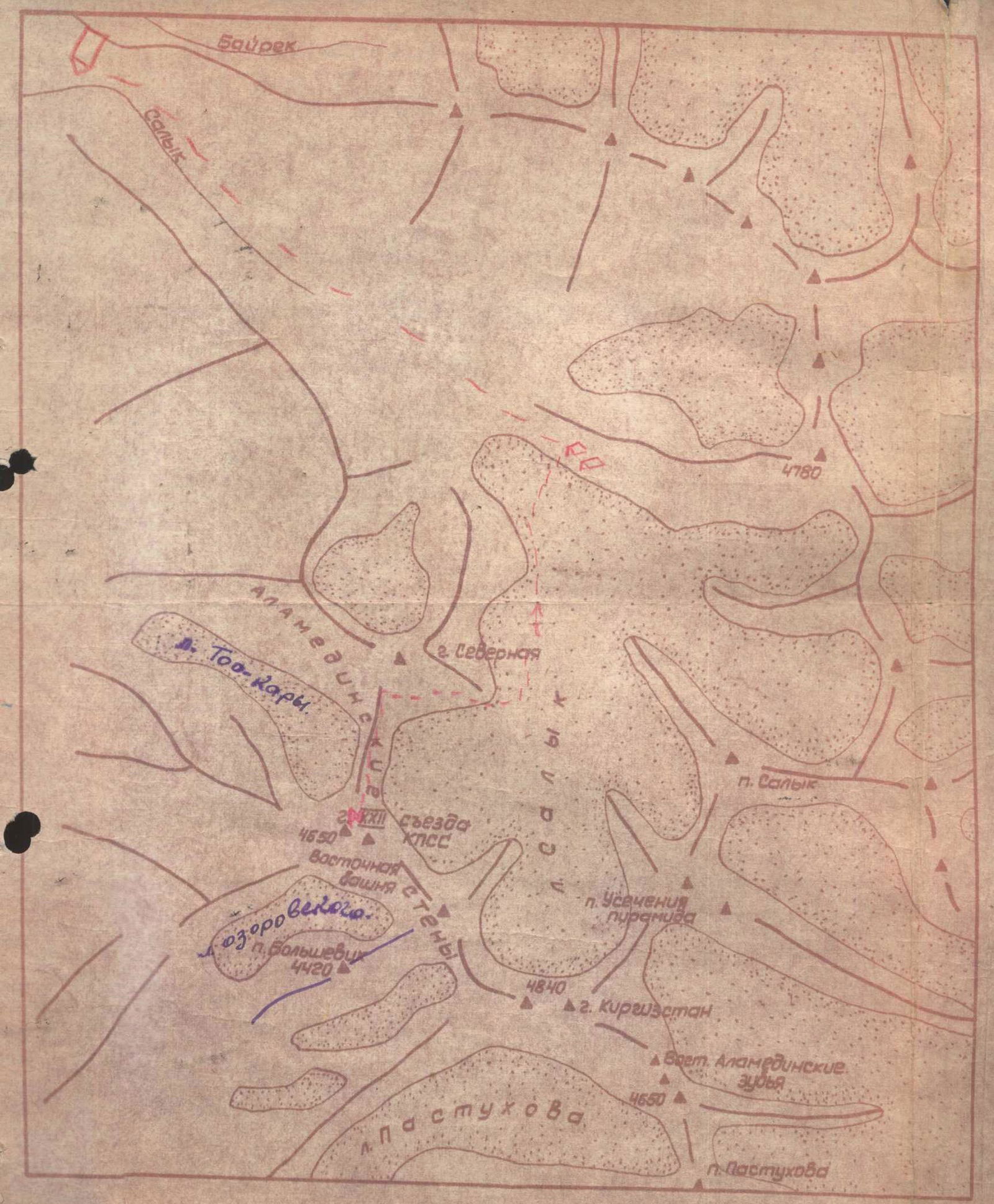
Peak "XXII Congress of the CPSU" is located in the Kyrgyz Range, part of the Western Tian Shan system, and belongs to the Alamedin River basin.
The northeastern and northern slopes of the summit descend to the glacier of the Salyk River basin, which flows into the Alamedin River.
The northwestern slopes of the summit, covered with ice, abruptly break off to the Peremin Glacier, located between the slopes of this summit and the northern peak of the Alamedin Wall.
The southern slopes descend to the Ozorovsky Glacier in the Alamedin River basin.
To the east and west of Peak "XXII Congress of the CPSU" are peaks that are of significant interest to climbers.
The height of the summit above sea level is 4650 m, with a relative height of about 1200 m.
In terms of sports, Peak "XXII Congress" is of significant interest. To the west, a ridge extends with an unnamed peak. The ascent along the northwestern counterfort, followed by a traverse of both peaks, is a route of the highest category of difficulty.
Ascent along two northeastern counterforts, as well as routes of higher difficulty.
The northern counterfort looks simpler compared to the above-mentioned routes.
All routes from the north are wall climbs. The southern slopes are significantly destroyed, and the ascent routes along them can be quite varied.
To the east, a very complex ridge extends, leading to the central and eastern peaks of the Alamedin Wall.
The Salyk Glacier has a significant accumulation area and stretches from 4 to 8 km. It has small icefalls, mainly located in the upper part near the accumulation area.
It is characteristic that the moraines of the glacier are composed mainly of medium and large debris. This is explained by the fact that the adjacent peaks are composed of granites of black, reddish, and gray color.
The moraines are generally not steep, except for the terminal one. The weather in the area of the Salyk Glacier is typical for the adjacent mountain regions of the Kyrgyz Range and is characterized by:
- stability,
- clarity at the beginning of the day,
- cloudiness and precipitation at the end of the day.
To the Salyk River gorge, located 60 km from Frunze, there is initially an asphalt road for 18-20 km to the Koy-Tash state farm, followed by 15 km to the Wolf Gates - a dirt road. Further along both banks of the river upstream, good cattle trails are laid out for about 20 km.
The Salyk River flows into the Alamedin opposite a well-defined rocky talus peak, which can serve as a good landmark. The journey from Frunze to the Salyk River takes 1.5 days.
Further along the right (orographic) bank of the Salyk River to the terminal moraine of the glacier, there is a well-defined trail.
The terminal moraine forms a height difference of up to 300 m, with a length of about 1.5 km.
To ascend the moraine, it is necessary to stick to the right (in the direction of travel) rocks - this path is simpler and less dangerous.
The journey from the mouth of the Salyk River to the terminal moraine takes 2.5 hours.
Further along the ridge-like medium and large moraines, it is necessary to move to the end of the glacier tongue, sticking to the middle.
The journey from the terminal moraine to the end of the glacier tongue takes 2.5 hours. Here, on the lateral moraine, you can find a convenient place for a bivouac (base camp).
Day 1
The glacier has a drainage and western branch, representing independent glaciers. The journey along the glacier to the turn takes 1.5 hours.
Next, it is necessary to:
- ascend the moraine to the western branch of the glacier,
- along the glacier, ascend to the talus (medium talus) slope leading to the pass between Peak "XXII Congress" and the northern peak of the Alamedin Wall.
A cairn is built on the pass.
The ascent to the pass along the talus is simple. The journey from the glacier turn to the pass takes 2.5 hours.
Below the pass, there are convenient areas for organizing a bivouac.
Day 2
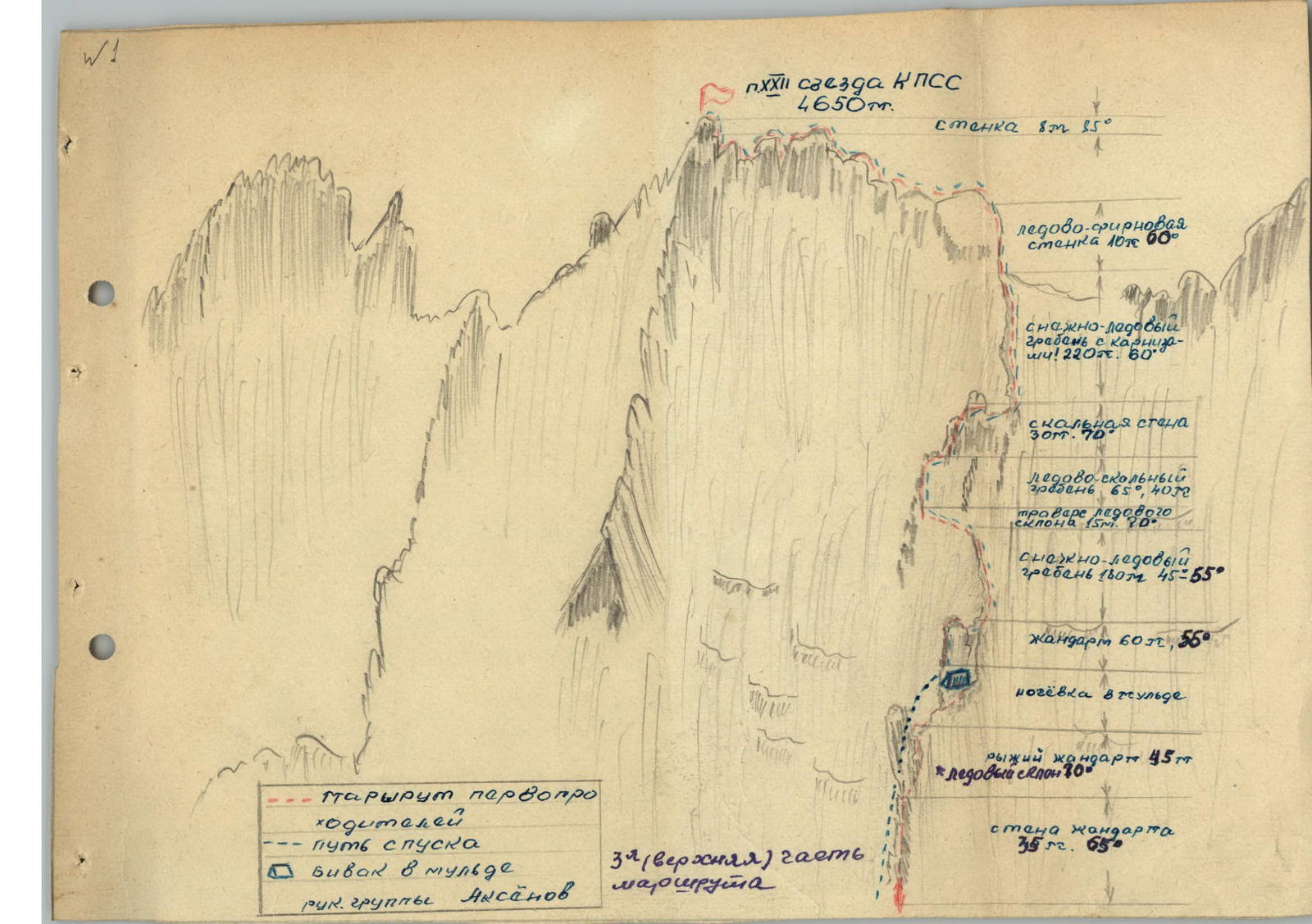
From the col, we move along the rocky ridge 2 m. The ridge leads to a rocky wall - 4 m. To the right of the wall, a rocky boulder has separated, forming a shelf-crevice 2 m. Along the shelf, we bypass the wall to the right. The shelf ends, leading to a sheer smooth section of the wall (5 m). This wall is passed along a barely noticeable ledge leading to an internal corner 1 m.
The place is complex: here, 3 rock anchors were hammered in for safety. The internal corner leads to a col. From the col, along the shelves, we descend below the ridge line by 15-20 m and move up along simple rocks for 60 m. Simple rocks lead to an internal corner with good holds - protrusions, ledges. The length of this section is 20 m, steepness - 60°. The internal corner leads to a rocky wall, with a steepness of 55° and a length of about 120 m. The wall has convenient areas for rest and safety every 30-40 m. The rocks are smoothed - like "sheep's foreheads." Passing the wall took the group 1.5 hours.
The wall leads again to the ridge to a gendarme, which is bypassed on the left. First, there is a smooth slab 3 m, then the slab abuts against a wall 1.5 m. The wall leads to a shelf 30 cm wide and 1.5 m long. Above the wall and shelf, a large "live" stone overhangs. The section is complex and dangerous, requiring careful safety. The shelf leads to a crevice 5 m with very poor holds. There are no cracks for pitons. The place is complex!
The crevice leads to a wide area, convenient for safety and rest. The journey from the beginning of the slab to the area took 1.5 hours. The length of this section is 30 m. 4 rock anchors were hammered in.
The area abruptly ends with a wall (2 m) on the ridge col. The col is narrow, and its passage requires careful safety. The col leads under a sheer rocky wall 7 m, smooth, devoid of cracks and holds. The wall is passed to the right:
- first under an overhanging section - 1.5 m,
- then along an icy internal corner - 6 m, 85°.
The corner leads to an area at the top of the wall. From this area, you can pull out backpacks. 4 anchors were hammered in. Passing this section took 1 hour.
Further along a narrow ridge with cornices - 90 m. The ridge is concave, heavily serrated, and requires careful safety.
The ridge leads to a col before an 80-meter wall. The wall has a steepness of 75° and has sufficient cracks, holds, and ledges. It is passed to the left.
First, to the left along a ledge about 40 m, 65°, then up along an internal corner 25 m.
The internal corner leads to smoothed slabs with a steepness of about 70°. Then along a ledge 4 m, we move to the right for 4 m and along a slab 45°, we approach a sheer wall 2 m, along which we exit to the ridge. The place is complex. 10 rock pitons were hammered in. Passing the wall in total took 2.5 hours. Before the wall, there is a convenient area; here, an overnight stay was organized.
The section of the route passed on the second day took about 10 hours. A total of 21 rock anchors were hammered in.
Day 3
The ridge after the wall leads to a sharp section of the ridge 2 m, then to slabs 12 m, with a steepness of 45°. Along the slabs, it exits to an area before a sheer 5 m wall.
The wall is passed along an inclined crevice (to the left) leading in the upper part to an area. The place is complex. 3 anchors were hammered in.
Passing the section took 50 minutes. Further along a sharp snowy ridge - 20 m.
The ridge flattens, forming an ice-snow hollow, convenient for an overnight stay. The hollow leads to a gendarme. Due to bad weather, the group stopped for the night in this hollow.
Passing the section of the route from the first to the second overnight stay took the group 5 hours.
Day 4
The "gendarme" is passed first along a wall 80°, 2.5 m. The wall leads to an inclined 60° crevice filled with ice, 4 m long. The crevice leads to a sheer chimney 2 m with smooth walls. The place is complex. Backpacks can be pulled up along the wall of the gendarme. 4 rock anchors were hammered in; passing the section took 1.5 hours.
Further, there is a snowy ridge 15 m, leading to a large reddish-colored "gendarme" up to 150 m high. The gendarme is passed first along a rocky edge 12 m, 80°. To the left and right are sheer walls. Further, the ridge widens, turning into a wall up to 40 m, 65°. The wall has convenient areas for rest and safety. Further, the ridge becomes narrow again - 35 m, 75°; the rocks are smoothed, with few holds and cracks. The rocks have a tiled structure. The upper part of the gendarme, about 50 m, is passed along a ledge 5 m, then along the edge of ice and overhanging rocks. The place is very complex, requiring careful safety. The steepness of this section reaches 80°. The exit to the gendarme is a key section of the route. Passing the section took a total of 9 hours.
4 ice anchors and 15 rock anchors were hammered in. Further, a complex snowy ridge with cornices 40 m leads to a snowy hollow; here, a bivouac is organized.
Day 5
The hollow leads to another gendarme 60 m, 70°. The gendarme is passed along a ledge to the left 8 m, then directly along the wall 20 m; the rocks are complex. Then along slabs about 30 m. Further up along a snow-ice ridge about 180 m, with a steepness from 40° to 65°.
The ridge leads to an ice slope 40 m, with a steepness of 60°. The slope is traversed in the upper part for 15 m to exit to the rocks. Rocks alternating with ice sections lead to a rocky wall 30 m, 60°. The wall ends with an area from which a steep up to 50° snow-ice ridge with large cornices begins. The length of the ridge is 220 m. The ridge leads to the shoulder of the summit. This section requires careful safety. The ascent to it is along an ice-firn wall 10 m, 70°. The ridge leading to the summit is sharp and has several walls 2, 3 m. The ridge is windy, requiring careful safety.
The summit tower is passed to the right along a ledge 4 m and then up along the wall 8 m. The place is complex. Further, the path to the summit is simple. It is advisable for the remaining group members to ascend directly along the wall 15 m in a sports manner. The descent from the summit is along the ascent path to the overnight stay, and then along a steep rocky-icy couloir to the glacier.
Passing the section of the route from the overnight stay to the summit and back took the group 10 hours.
Hammered in:
- 8 ice anchors,
- 10 rock anchors.
Thus, the ascent to the summit took 45 hours. The fact that the group spent such a significant amount of time is explained by the snowy nature of the route and bad weather. A total of:
- 50 rock anchors,
- 18 ice anchors were hammered in.
The descent from the summit to the glacier took the group a total of about 10 hours.
The first ascent from the north to Peak XXII Congress of the CPSU was made on October 3, 1961, by a sports group of the expedition organized by the city sports council of Frunze, consisting of:
- Aksenov V.A. - 1st sports category - leader.
- Tishchenko V.S. - 2nd sports category.
- Litvinov V.F. - 2nd sports category.
- Kochetov V.I. - 2nd sports category.