Ascent Certificate
- Ascent category — high-altitude technical climb.
- Region — central Tian-Shan mountain range.
- Peak — Nansen Peak, 5697 m, via the North Ridge, combined route.
- Estimated category of difficulty: 5B.
- Route characteristics: height difference — 2850 m, length of R5 section — 700 m, average slope — 55°.
- Pitons used: rock — 66 pieces, ice — 55 pieces.
- Total climbing hours — 36.
- Team leader — Oleg Matveevich Solovei, Candidate Master of Sports; team members: Valery Kuzmich Otchik, Candidate Master of Sports; Vasily Mikhailovich Tereshkovets, 1st sports category; Valery Ivanovich Petko, Candidate Master of Sports.
- Number of bivouacs — 6: № 1 — on scree below the snowline, № 2 — on a rock ledge, № 3, 4, 5 — on a ridge, № 6 — on a moraine.
- Coaches: V.K. Otchik, L.I. Lozovsky.
- Started the climb on July 12, 1953 at 15:00. Returned to base camp on July 18, 1953 at 12:00.
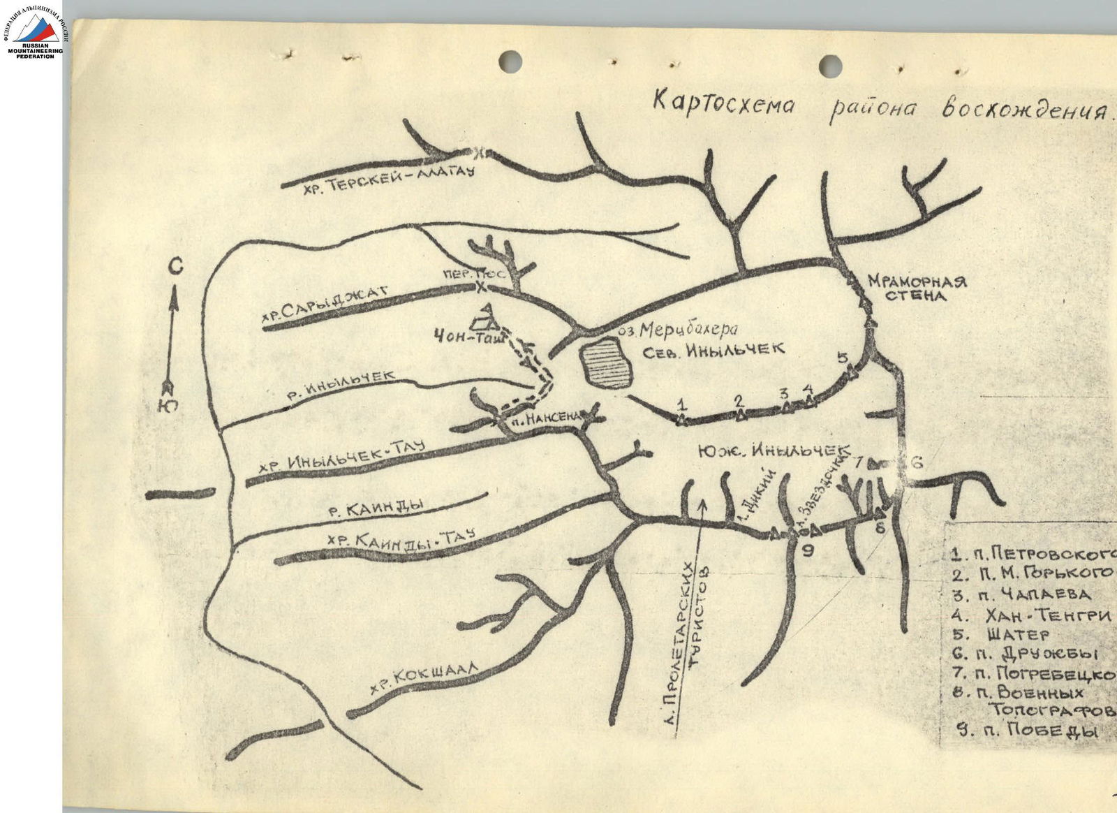
Brief Description of the Approach to the Route
From the Chon-Tash base camp, follow the road and Inylchek Glacier, crossing the right orographic tributary of the Inylchek River (ford available). Traverse the glacier tongue to the right towards the slopes of Nansen Peak, bypassing the sources of the Inylchek River, to the start of the route.
The route begins along a stream flowing from Nansen Peak (left of the north ridge).
Approach time: 1.5 hours.
Brief Description of the Route
The route starts by ascending a couloir along a stream flowing from Nansen Peak, leading to a large scree-filled cirque. Then, traverse a ridge to the right, crossing a wide couloir and a stream, and ascend an osypnoy (scree) grassy slope to a broad, degraded ridge. Follow this ridge to the first rock pinnacle at the snowline (Section R0–R1). 5 hours from base camp. Bivouac on a scree site.
Bypass the first rock pinnacle on the left via ledges. Ascend to the second pinnacle via a snow-ice ridge. Continue up snow and ice to the inner corner of the right part of the pinnacle (Section R1–R2).
Bypass the overhanging part of the pinnacle on the right via osypnoy ledges, ascending and then left to reach an ice ridge (Section R2–R3). Continue up the ice slope to beneath a rock wall (Section R3–R4). Climb 5 rope lengths up the wall. Climbing is challenging; rocks are heavily degraded, with some ice. Reach a small ridge (R4–R5). Bivouac on a small ledge with the tent and team members on belay.
Continue with 4 rope lengths of challenging climbing on snow-covered rocks, reaching a sharp rock ridge (R5–R6). Ascend the ridge, then left across ice and rocks to the main snow ridge (R6–R7). Follow the snow ridge up and to the right, bypassing a large ice cornice on the right to reach a snow dome (Section R7–R8).
Descend 100 m down a snow slope, then ascend 150 m. Follow a sharp snow-ice ridge, descending to a broad col (Section R8–R9). Bivouac on snow. From the col, ascend a snowy slope turning into a sharp snow-ice ridge. Beware of cornices on the left! (300–350 m). Continue to a gentle, broad snow slope with cornices on the left. Ascend the slope to beneath ice "islands" near the summit dome (Section R9–R10). Bypass the first large ice "island" from below, moving up and to the right towards rocks. Then, ascend along rocks via ice and snow, leaving the rocks on the right, to a snow shoulder (Section R10–R11).
Ascend 4 rope lengths up the shoulder to the summit ice slope (cornice on the left). Reach the snow-ice summit dome. Descend via the 5A category route.

(On section R6–R7)