ASCENT DOCUMENT
I. Ascent category — rock climbing.
2. Ascent area — Trans-Ili Alatau.
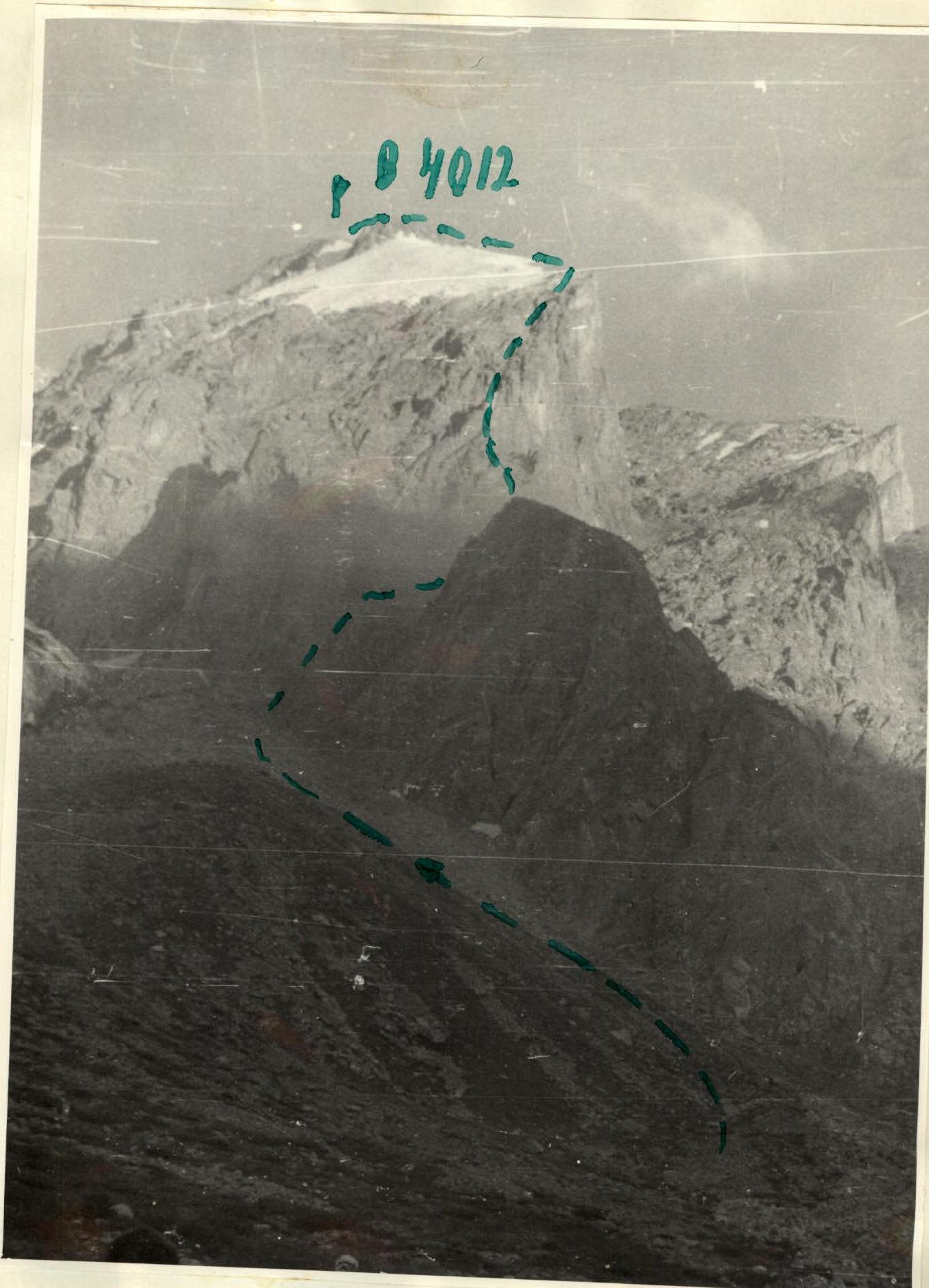
3. Peak "4012", route via the North-West ridge.
4. Estimated difficulty — 4A category.
5. Route characteristics: height difference 900 m, section length 5 — 90 m, average slope — 40°.
6. 23 rock pitons hammered in.
7. Total climbing time — 13.5 hours.
8. Number of nights — no overnight stay.
9. Group composition:
Shibaev S.A. — 2nd sports category — leader
Alparov A.M. — 2nd sports category
Kuznetsov E.P. — 2nd sports category
Pirogov A.V. — 2nd sports category
10. Team coach — Dauter B.V. — Master of Sports of the USSR.
II. Departure date — August 1, 1977, return date — August 1, 1977 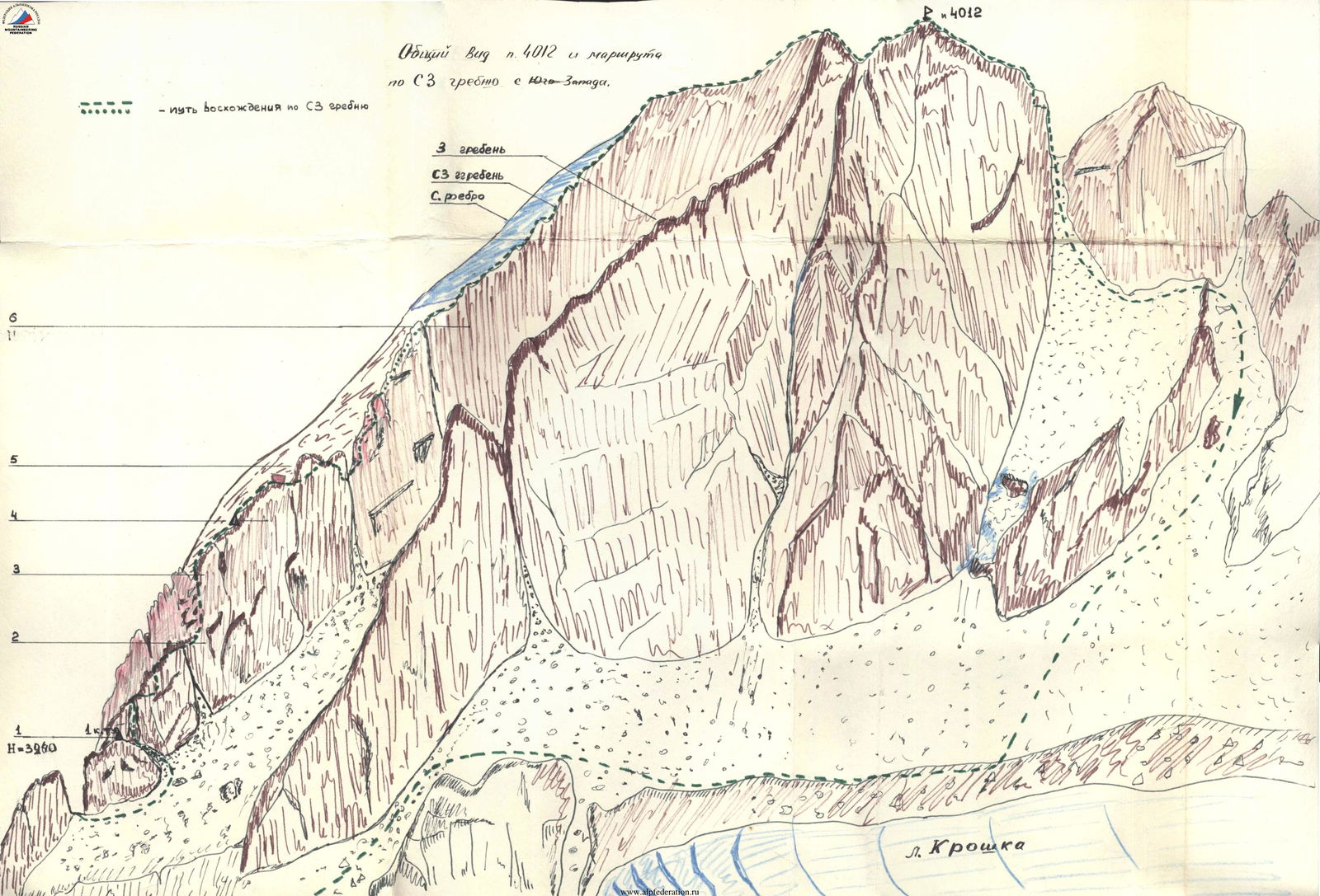
Description of the ascent route to peak "4012" via the North-West ridge
Peak "4012" is located in a spur of the main ridge Trans-Ili Alatau, dividing Gl. Kroshka and Gl. Yu. Talgar. Approach: from the Talgar alpine camp along the trail to the signpost turning to Gl. Yu. Talgar and further up the moraine under the N.W. ridge of peak "4012". (Time to approach — 3 hours)
The route begins at the confluence of two upper couloirs descending to Gl. Yu. Talgar from the N.W. ridge.
1st section. Ascend up the left couloir to the ridge. Then, to the right of the ridge, along a wide scree terrace, ascend 150 m to a ledge going left upwards. From the ledge, exit to the ridge. 1st control point. Time for the section — 30 minutes.
2nd section. From the 1st control point, ascend directly up the wall 30 m. The steepness of the wall is 70°, with a slight overhang at the top (the first in the group is recommended to go without a backpack). Exit to a wide scree ridge. Along the ridge — to a wide couloir with large stones. The couloir leads to a col under a sheer wall. Time for the section — 1 hour.
3rd section. From the col — along a ledge, exit to an internal corner. Up the internal corner (45 m, 70°; with a slight overhang in the middle) ascend to a col. To the left under the wall — a platform convenient for belaying. From the platform:
- directly up the wall, left of the ridge (50–60°, 30 m);
- at the top of the wall, in a niche — 1st control point.
Time for the section — 1.5 hours.
4th section. From the 2nd control point, traverse left 15 m into a gentle couloir. Along the couloir and then along the "steps" — exit to the ridge: a table-like platform with a large stone. Further to the right of the ridge, along a flake and a ledge — exit to the saddle of the ridge. Descend left 4 m to a terrace. From the terrace, along a ledge, then along a flake (rappel 5 m) and a narrow ledge — descend to a col. Time for the section — 1 hour.
5th section. From the col, ascend directly up the wall (45 m), starting with a red slab. The average steepness of the wall is 60°, with complex vertical sections. Along the wall, exit to the ridge and further along simple rocks to the summit of a gendarme. Time for the section — 1.5 hours.
6th section. From the gendarme, ascend along slabs to the ridge. Further along a straightforward ridge, exit to the summit, descend to the ridge into a dip and exit to the 2nd summit (the summits are close in height). Time for the section — 2 hours.
Descend from the 2nd summit along the ridge in the direction of peak "Trud". Further descend into a dip on a col (rappel 35 m). From the col, along a scree couloir, descend to Gl. Kroshka. Along the trail under the walls of peak "4012", descend into the gorge of the r. Sredny Talgar and further to the Talgar alpine camp. Time to descend — 3 hours.
The group made the ascent without an overnight stay on the route. Departure from the Talgar alpine camp on August 1, 1977 at 4:00, return at 17:30.
Table of main characteristics of the ascent route to peak "4012" via the N.W. ridge 
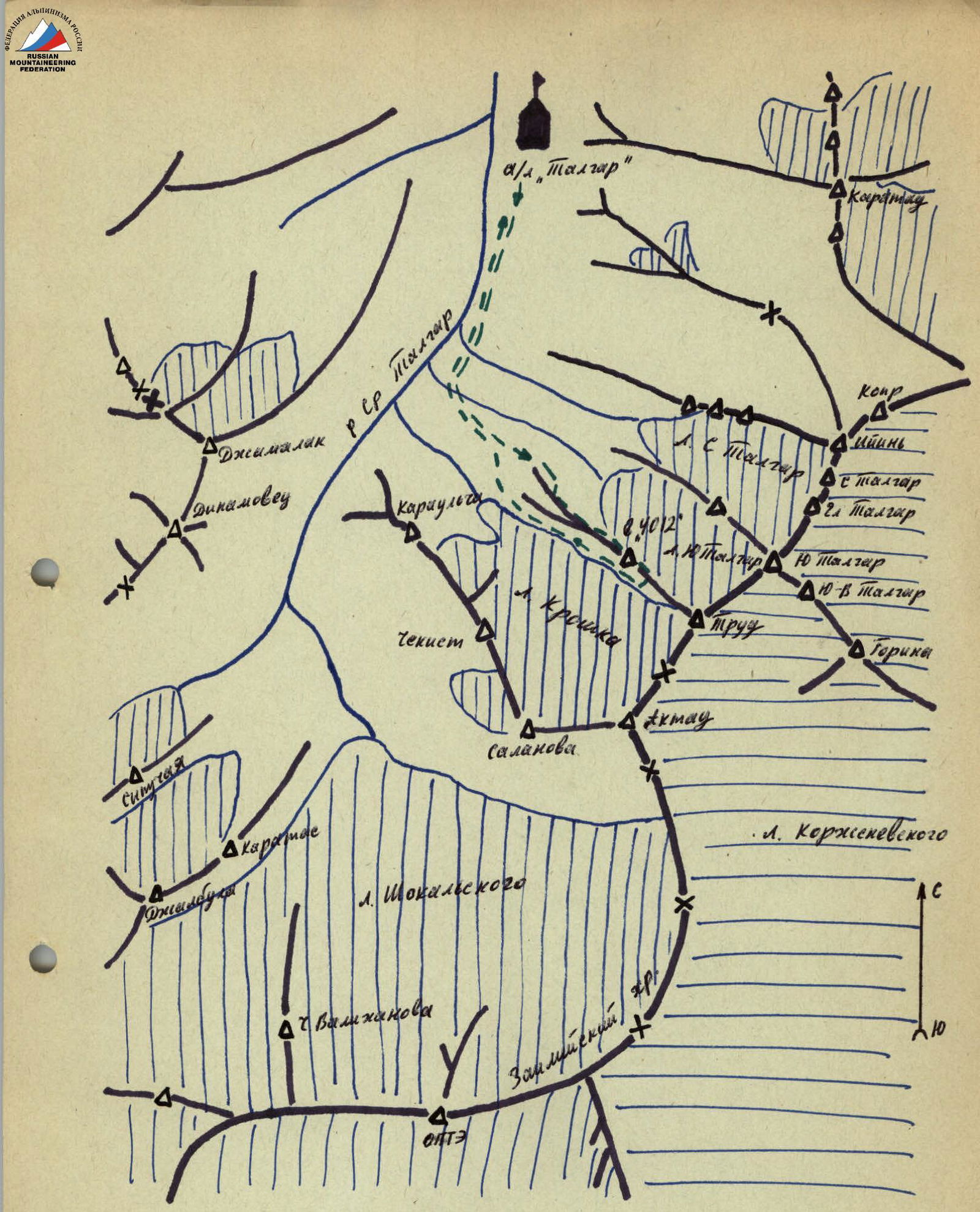
Map of the ascent area