
Ushbas - Abay Kunanbaev, 45. Traverse of 3 peaks.
M. Bryksin, 1958
October 18-22

Group's route
I. Orography
The North-West ridge departs from the Trans-Ili Alatau ridge in the area of Iiyintau. Three peaks rise above the strongly torn ridge crest:
- 1st Nameless "Treзубец" 4150 m above sea level
- 2nd Nameless "False peak" 4250 m above sea level
- Abay Kunanbaev 4440 m above sea level
The first two peaks were climbed for the first time, and the route to the third one is classified as Category 3B with the Kopr glacier.
The northern slopes of the ridge are icy rocks and ice slopes; the southern ones are steep rocky walls up to 400-500 m deep.
The southern slopes are subject to intensive weathering, so they are badly damaged in many areas.
The Kopr glacier (about 1.5 km long) lies to the north of the described ridge, and the North Talgar glacier - to the south.
The weather during the ascent was favorable; a slight fog and snowfall on the third day of the assault did not interfere with the task.
II. Organizational and tactical plan
This event was organized by the Republican Club of Mountaineers and Tourists with the task of improving the sports skills and fulfilling the classification standards by the team members.
The tactics of the traverse were built as follows:

A group of 4 people goes on the assault, leaving the return deadline for the second group led by Master of Sports Comrade ALEKSEYEV V.M., who is in the Talgar alpine camp, and during the day goes to the moraines of the Kopr glacier for visual observation. Communication was carried out by light signals at 20:00 every day. Due to the early onset of darkness (second half of October), the route for the day was built from the calculation of 8-9 hours of movement, which made it possible to choose places for overnight stays in advance.
III. Information about the group
The described route was completed by a group consisting of:
- BRYKSIN P.P. - leader, 1st sports category in mountaineering
- KULEMIN M.S. - participant, - " -
- SAVUKHIN V.V. - - " - , - " -
- KIREEV G.P. - - " - , 2nd sports category
The group was part of the combined team of the Kazakh Mountaineering Club, which carried out complex ascents in the Talgar massif area.
The rope teams were distributed in the following order:
- BRYKSIN - SAVUKHIN,
- KULEMIN - KIREEV.
The traverse participants were provided with fuel, food for five working days and the following equipment:
- Down sleeping bags ... 4 pcs.
- Down suits ... 4 sets
- Storm suits ... 4 - " -
- High-altitude boots (insulated) 4 pairs
IV. Route description
Day 1 - October 18, 1958. At 10:30 the group left the Talgar camp. At first, the path goes along a good trail on the right (orogr.) side of the Middle Talgar River to an ancient terminal moraine, from where we turn left into the side valley of the Kopr glacier.
Overcoming the jumble of ancient moraines of the glacier, not reaching the "Rakhimov" bivouac, we cross the moraines towards a wide couloir descending to the north in the western extremity of the ridge.
The path to this couloir takes only 3 hours, so it was decided to start the ascent on the same day.
The ascent goes in the middle part of the couloir along the talus, and then along the gentle slabs covered with separate stones, towards the rocky island. Leaving the rocks on the left, we go to the right into the couloir narrowing from above.
The steepness in the upper part of the couloir increases to 45-50°. The movement goes at the foot of the rocks on the right along the way. Before reaching the ridge, approximately 2 ropes need to be traversed with insurance, as the slab-like rocks complicate the movement.
These slabs lead to a narrow saddle on the ridge. The time of exit to the ridge is 2 hours.
After moving 4 ropes along the ridge and overcoming the 1st "Zhandarm", we realized that there would be no place to bivouac in the near future, as further on there is a narrow ridge abutting a huge rocky tower, breaking off to the south with walls, to the north - with steep slabs. Therefore, we had to return to the saddle and, having gone 0.5 km along the couloir 120 m below, to a more gentle section of the ridge, built a platform out of stones and put up a tent in the twilight.
The work time on the 1st day is 6.5 hours.
Day 2, October 19, 1958. We continued our journey to the "Treзубец" peak from the overnight stay. Along the couloir we again reached the ridge saddle and began to move along the characteristic red rocks, which lead to the foot of a wall made of gray granite. It is a huge jumble of rocks, polished by ice and wind. Along the inner corner, 10-12 m long, having hammered in one piton for insurance, we exit to the upper part of the 1st "Zhandarm" (photo No. 1). Further on there is a heavily destroyed ridge, consisting of huge boulders in an unstable equilibrium. We move along the ridge for 30-40 m and begin to descend along the right ridge.
From the gap we go to the right to bypass the "Zhandarm" (red finger 15 m high) towering above the ridge.
Having moved forward along the ridge for 20-25 m after the "Zhandarm", we begin to ascend along steep snowy rocks and slabs (photo No. 2).
Here insurance is necessary through rock pitons and ledges for 100-120 m, having overcome which, we find ourselves at the rocky tower and sharply turn to the right. Hammering in rock pitons all the time, we traverse 50 m of the wall (photo No. 3) and go up to the left along a 30-meter chimney.
The upper part of the chimney is difficult to pass; 5 pitons were used at the exit from it.
(photo No. 4)
Having reached the ridge, the lead mountaineer fixes the rope for the belay, along which the other participants move. Further movement occurs on the right, slightly below the ridge, to a 50-meter rocky wall (photo No. 5).
Having overcome the wall, we exit into a steep couloir, having ascended it for 30 m. We cross to the right onto the ridge of the southern counterfort stretching towards the 1st peak of "Treзубец". Having gone to the right of the counterfort ridge along the terrace, we find ourselves in a steep rocky chute and ascend along it to the aforementioned peak. The first note is left here (photo 6).
From the peak we descend to the right along the rocky chute for 25-30 m, slightly below the saddle into the southern couloir and begin to ascend along the combined 80° chute of the double-toothed "Dandarm".
At first, for 25 m, the path goes up and to the right towards a rocky ledge on the right along the way. Then, along a narrow inclined ledge (25-30) we pass forward for the length of 1 rope (photo No. 7).
Further along steep slabs to the foot of a 15-meter wall. The wall is sheer, difficult to move, and is passed without backpacks.
After the wall, we move along the ridge to the "Dandarm", which is bypassed on the right, and again find ourselves on a heavily destroyed ridge (photo No. 8).
Having passed along the horizontal part of the ridge up to a 3-meter gap, we descend into it, bypass a huge rocky boulder hanging over the abyss.
The further path goes along a very sharp ridge, breaking off on both sides (photo No. 9). Having overcome a 4-meter "Zhandarm" on the ridge, we reach the second peak of "Treзубец" (the highest point is 4150 m above sea level). Here is a control note.
Day 3, October 20, 1958. Descent to the southeast, maneuvering between rocky boulders on 1 rope, the slope breaks off with a 25-meter wall. Descent sitting on a rope, then movement to the east along the couloir, bypassing the peak on the right, to the saddle of the main ridge. Then, on the right along the ledges, we bypass the "Pandardm" and descend to the saddle of the counterfort itself, where we organize the second overnight stay. On the second day, it took 9 hours to overcome the route. From the overnight stay, we descended to the east along the couloir and along the ledges moved towards the foot of the rocky tower. The exit to the tower is along the walls with piton insurance (photo No. 10). Having reached the tower, we move a distance of 3 ropes along the ridge and leave a control note here.
Having descended 10 m to the right, we organize a 30-meter rappel "Dulfer" to the east and to the saddle (photo No. 11). Having descended below the saddle, we traverse to the right along the ledges and, having overcome a 6-meter wall, reach the slabs, along which we ascend to the ridge. Having moved along the ridge for 100-120 m (through several walls), we reach the 3rd peak of "Treзубец" - a control note is left.
The descent from the peak goes to the snow saddle along a heavily destroyed ridge, requiring great caution so as not to dislodge the stones that are in a very unstable equilibrium. This is the first saddle that is suitable for an overnight stay.
On this day, 8 hours were spent on the route and 2 hours on reconnaissance of the further path from the snow saddle. Further reconnaissance indicated a great complexity of this section. And the group decided to move from the overnight stay without backpacks to the peak of A. Kunanbaev, and then return back.

Day 4, October 21, 1958. From the snow saddle, the path goes along icy rocks for 80 m. Then there is a descent to the right under the ridge and along the destroyed ledges bypassing the next "Pandardm".
Having passed the saddle, we pass under the rocks of the next "Zhandarm". From here, the path goes along an icy couloir and steep slabs.
Having overcome it, we turn to the left into a rocky couloir, which leads to the ridge with several rocky walls (photo No. 12), requiring careful insurance.
This ridge leads to a 60-meter ice-rock wall, having overcome which, we reach the pre-summit of the "False peak". Here is a control cairn.
The route to the "False peak" (4250 m above sea level) passes along a gentle ridge. Only in the middle of the way it is necessary to bypass the "Zhandarm" on the left along a steep snow patch. On the "False peak" there is a cairn (photo No. 13).
The descent from the peak goes to the southeast along heavily destroyed rocks. On this path, there is a steep couloir (below the saddle between the passed peak and the beginning of the ascent to peak A. Kunanbaev).
The ascent to the peak of A. Kunanbaev goes along a giant rocky chimney (90-100 m long) with smooth sheer walls (photo No. 14). Climbing the chimney is done by jamming; insurance is provided through rock pitons.
The ascent along the chimney begins along rocks of medium difficulty (one rope) with piton insurance and exits onto a sloping platform on the left side of the chimney (along the way). Above the platform, a rocky cornice overhangs; on the left there are impassable negative walls; on the right there is a small (6 m) wall, which leads to a horizontal platform for two people.
With careful insurance through a rock piton, the first climber, using various rock climbing techniques, overcomes the wall and reaches the platform, where he hammers in a piton and takes in the second climber.
From the platform, for one rope, there is a heavily smoothed wall. There are no cracks for pitons. There are no ledges. On piton insurance, the first climber very cautiously, deviating inwards slightly to the right along the way, exits to the length of the entire rope to a sloping rocky platform and, having hammered in a piton, takes in the second climber.
From this place, we traverse to the right along a steep icy couloir (one rope) and find ourselves on a platform covered with snow.
From here, bypassing the "Zhandarm"s on the right and left, we exit onto the ridge, which leads to the peak. The ridge is heavily destroyed; we approach the rocky walls very cautiously, with insurance through ledges (photo No. 15), and begin to bypass them on the right along medium rocks and interspersed slabs (3 ropes), which abut against a steep (60-70 m) icy couloir 2 ropes long. Holding to the left edge along the way of the couloir with piton insurance and insurance through rocky ledges, we exit onto the shoulder of the peak, from where we reach the very peak of A. Kunanbaev (4440 m above sea level) along the ridge with simultaneous movement.
The descent from the peak along the ascent route to the place of the third overnight stay is carried out using "Dulfer" in the following places:
- along the icy couloir - 2 ropes,
- traverse of the walls - 2 ropes,
- in the chimney - 2 ropes,
- at the highest point - 2 ropes,
leaving several pitons and rope loops.
We arrived at the overnight stay in complete darkness (at 19:00), that is, having spent 10.5 hours on the assault on this day.
Day 5, October 22, 1958. Immediately from the place of chimney of 3 and 4 o'clock, the descent to the north begins along an icy couloir to the Kopr glacier. The path goes to the left (along the way at the rocky walls of the northern counterfort), bypassing a rocky ledge, approximately 40-50 m after the start of the descent from the saddle.
A piton is hammered in at the rocky ledge for insurance. From here, we again begin to descend towards the rocky wall, where a rock piton is hammered in and a loop is left for rappel descent on crampons. After 30 m, another rock piton is hammered in. Then the movement continues in the same direction, using 3 ice screws.
Having reached a narrow couloir formed by the aforementioned counterfort and the rocky island on the right, another ice screw is hammered in, through which we organize further descent to the glacier. Then we cross the moraines in a northwest direction and find ourselves on the previously described trail leading to a/l "Talgar".
Along the trail, 6 hours after the start of the descent, we return to a/l "Talgar".
V. Conclusion
-
The route of the traverse of 3 peaks belongs to the category of rock routes. It abounds with a large number of complex sections requiring the use of all techniques of rock climbing.
-
The strong destruction of rocks creates additional difficulties.
-
The great length of the route requires great physical and volitional endurance.
-
In its length, this traverse surpasses, and in technical difficulty is not inferior to, the route 5A category on peak Metallurg, which is more suitable in its structure.
-
During the traverse, 28 rock and 6 ice pitons were hammered in on the route, 7 rope loops and one carabiner were left.
-
Based on the above, the group evaluates this traverse as 5A category.
(Bryksin) (Kulemin) (Savukhin) (Kireev)
The original is correct.
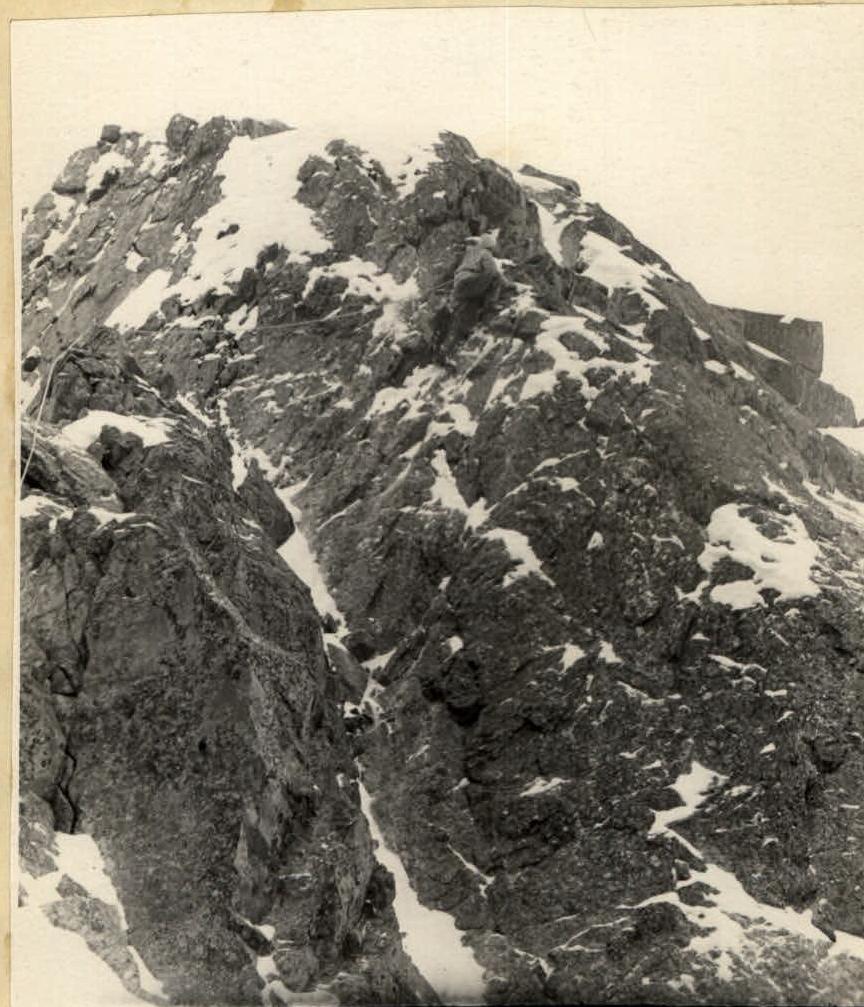 Photo 2. Ascent along snowy rocks.
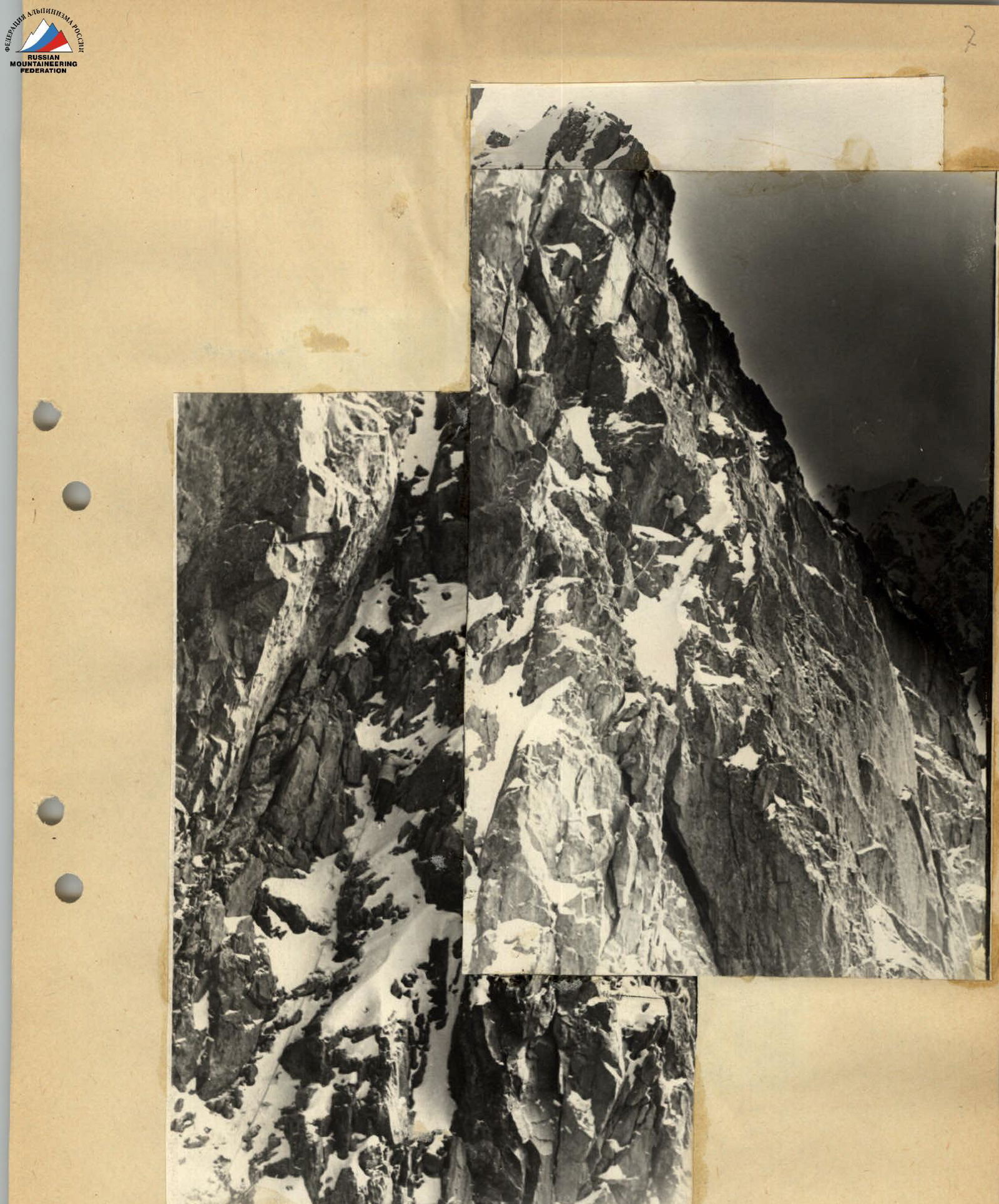 Photo 7. Ascent to the double-toothed "Zhandarm".
 Photo 9. Section of a sharp ridge.
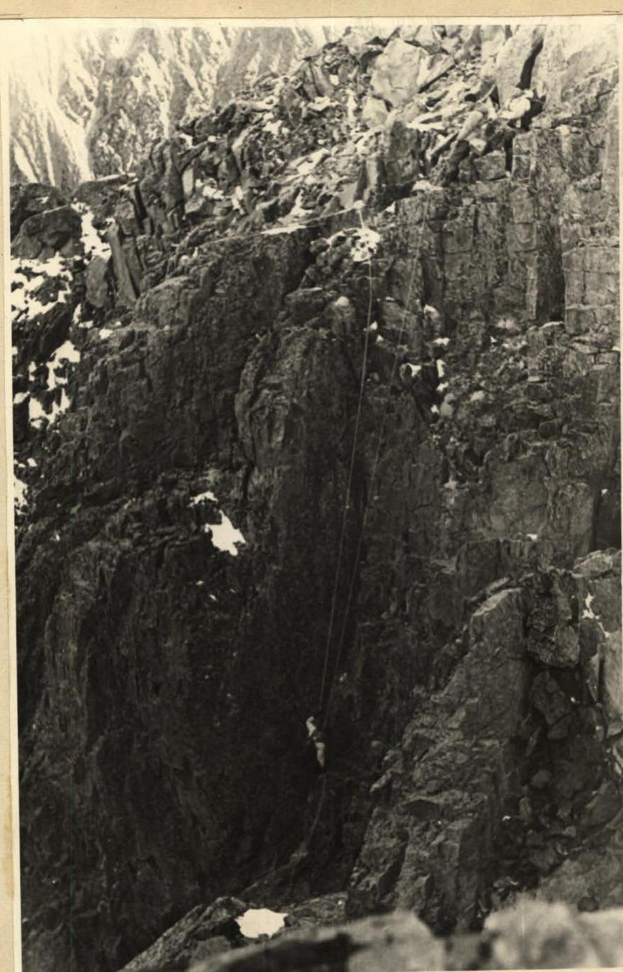 Photo 11. 30-meter rappel.
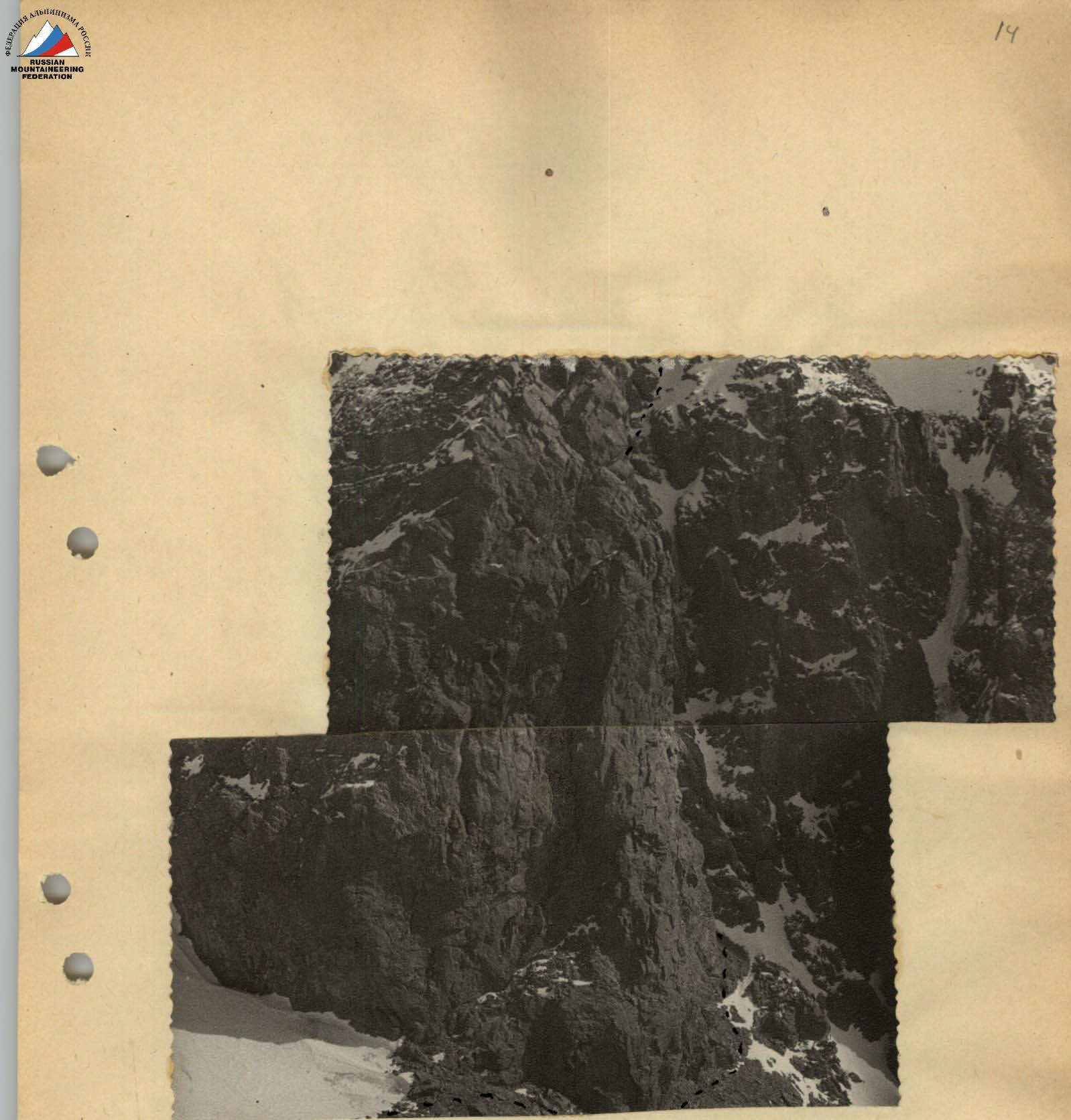 Photo 14. Giant chimney.
Comments
Sign in to leave a comment