-
Climbing category: technical
-
Climbing area: Trans-Ili Alatau ridge
-
Peak, its height, and ascent route: peak "TRUD", 4650 m, via the right part of the Western wall, first ascent.
-
Estimated route category: 5B
-
Route characteristics: height difference — 1180 m, average steepness — 55°, total route length — 1560 m, section lengths:
- 3rd difficulty category — 415 m
- 4th difficulty category — 580 m
- 5th difficulty category — 540 m
- 6th difficulty category — 25 m
-
Pitons used:
- for protection — 189
- for creating artificial anchors — 10
| rock | — 176 | — 10 |
| ice | — 13 | — 0 |
| bolt | — 0 | — 0 |
-
Number of placed protection devices — 31
-
Total climbing time — 39.5 hours
-
Number of bivouacs and their characteristics — 3 (lying down)
-
Team leader and members, their sports qualification:
- Yun Vitaly Mikhailovich — Candidate for Master of Sports
- Korolev Sergey Alexandrovich — Candidate for Master of Sports
- Nikolaev Vladimir Nikolayevich — Candidate for Master of Sports
- Andryushkevich Konstantin Ivanovich — Candidate for Master of Sports
-
Team coach — Okladnikov V.E., Master of Sports of the USSR
-
Date of departure and return — August 13, 1982 – August 17, 1982
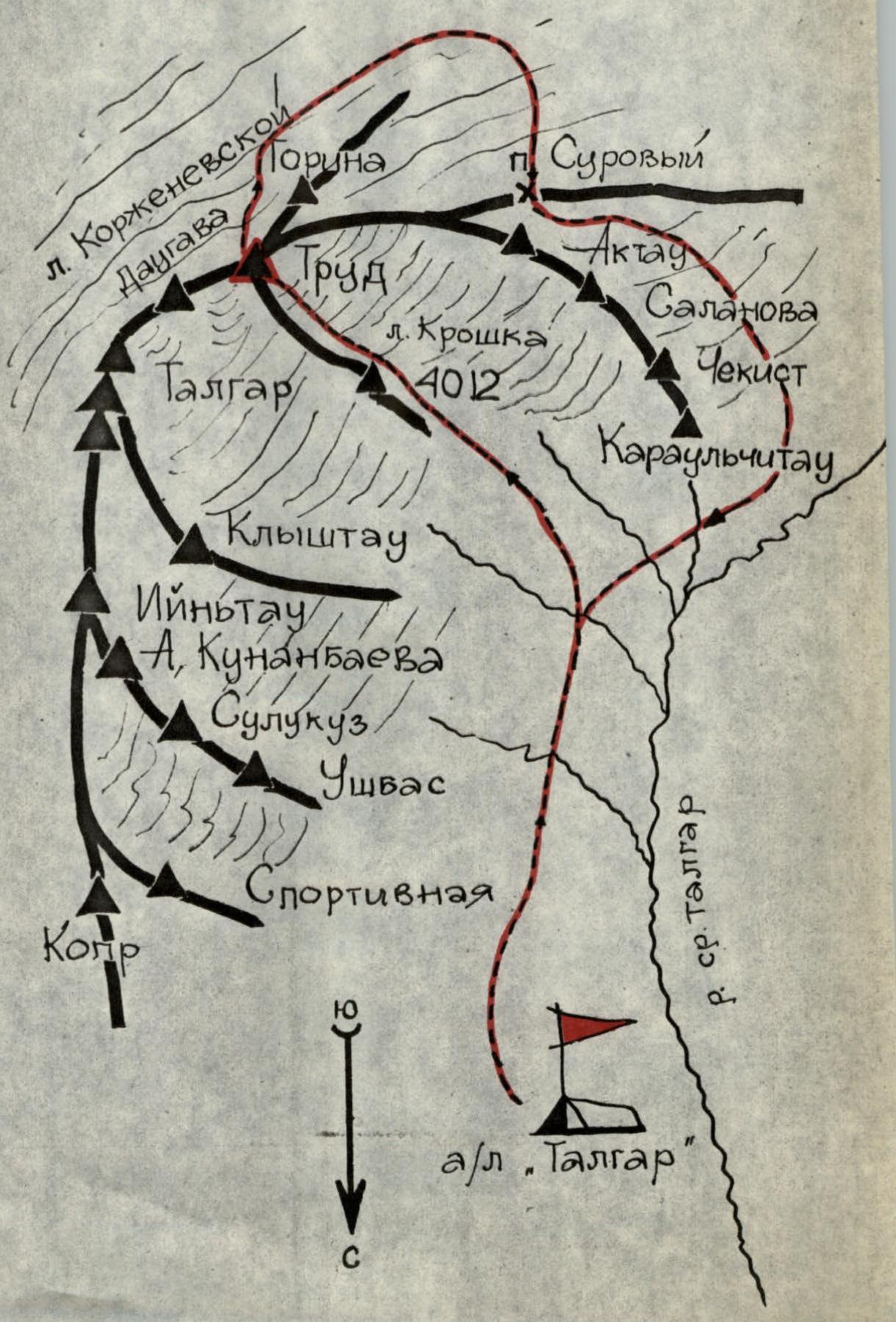
Area Map
Route Description
The valley of the Middle Talgar River is bounded from the south and east by the main ridge of the Trans-Ili Alatau, forming the Shakalsky glacier cirque and reaching its maximum heights and glaciation in this area. Four short ridges form five chambers of the Shakalsky glacier.
North of the Surovyy pass, the ridge:
- Takes a northeasterly direction
- Its height increases sharply
- Reaches 4754 m at the AkTau ice pyramid
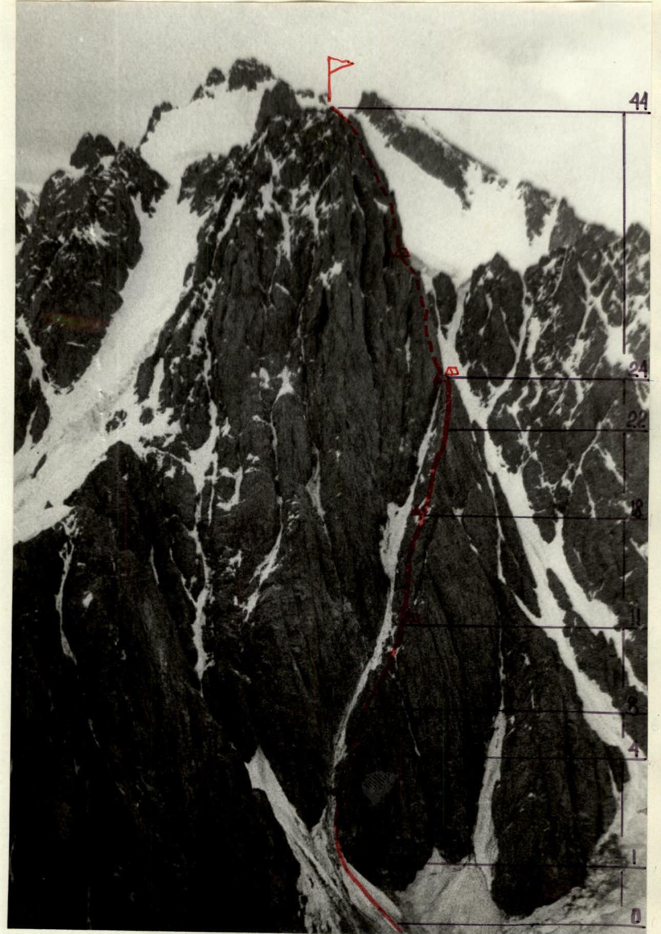
Peak Trud is located in a small unnamed spur of the Trans-Ili Alatau ridge. The same-named northwestern spur separates the Shakalsky glacier from the Kroshka glacier cirque.
The path to the summit starts from the Talgar alpine camp, up the valley to the Kroshka glacier. Ascend onto the glacier, keeping to the left side, under the wall of peak 4012. Three hundred meters from the "Trud" wall, on the moraine, is a bivouac site.
Section R0–R1. Up the avalanche slope 80 m at 40° (ice) to the left side of a giant rock triangle, separated from the main wall by an ice couloir (rockfall hazard!).
Section R1–R2. Up the wall 30 m (monolith) to a destroyed wall. Under the wall, a platform for two (unstable rocks!).
Section R2–R3. From the platform, right under the destroyed wall, along a 20 m long ledge with a gap in the middle, to an internal corner.
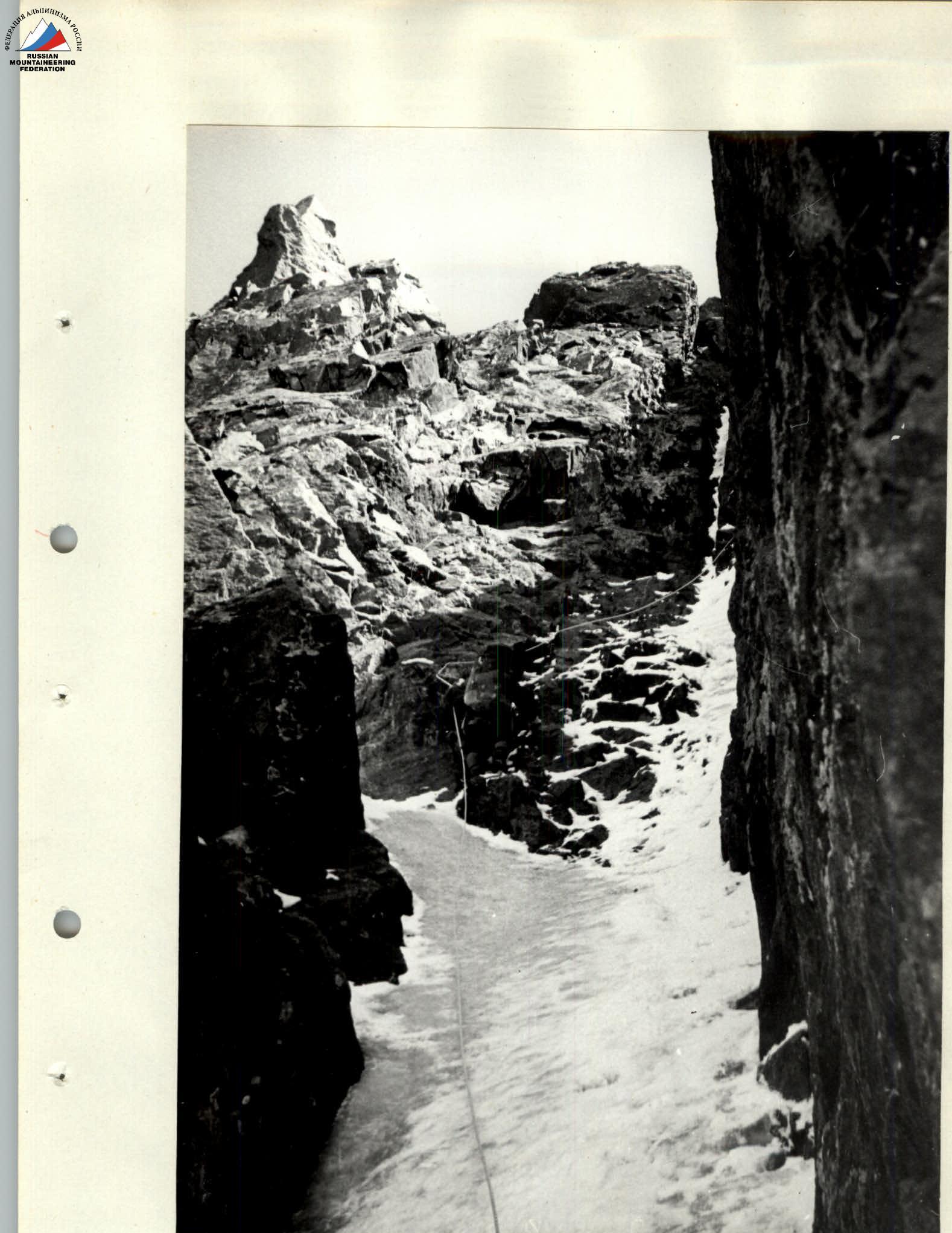
Section R3–R4. Up the internal corner (monolith) at an average steepness of 75° and a length of 35 m to a ridge. Six pitons were used.
Section R4–R6. Along the ridge at 50° steepness and 15 m length to a slab with few holds 20 m under the wall.
Section R6–R8. Destroyed wall at 55° steepness and 25 m length — a sharp ridge. Rocks of moderate difficulty.
| Date and time | Section designation | Average steepness | Length | Terrain characteristics | Difficulty | Route condition | Rock pitons | Bolt pitons | Ice pitons | Weather condition | Remarks |
|---|---|---|---|---|---|---|---|---|---|---|---|
| 14.08.1982 | |||||||||||
| 7:00 | R0–R1 | 45° | 80 m | snow, ice | 3 | snow, ice | — | — | 2 | good | |
| 7:30 | R1–R2 | 70° | 30 m | wall | 4 | monolith | 5 | — | — | good | |
| 10:00 | R2–R3 | 30° | 20 m | ledges | 3 | destroyed rocks | 1 | — | — | good | |
| 11:40 | R3–R4 | 75° | 35 m | internal corner | 5 | monolith | 6 | — | — | good | |
| 13:00 | R4–R5 | 50° | 15 m | ridge | 4 | destroyed rocks | 1 | — | — | good | |
| 15:50 | R5–R6 | 70° | 10 m | slab | 5 | monolith | 2 | — | — | satisfactory | |
| 16:30 | R6–R7 | 55° | 25 m | wall | 4 | destroyed rocks | 3 | — | — | poor | |
| 17:20 | R7–R8 | 40° | 25 m | ridge | 4 | destroyed rocks | 1 | — | — | poor | snow |
| 18:00 | R8–R9 | 75° | 15 m | slab | 5 | monolith | 3 | — | — | poor | snow |
| 19:10 | R9–R10 | 60° | 35 m | wall, ledges | 4 | destroyed rocks | 4 | — | — | poor | snow |
| 20:00 | R10–R11 | 25° | 50 m | ridge | 3 | destroyed rocks | — | — | — | poor | snow, bivouac |
| 15.08.1982 | |||||||||||
| 8:50 | R11–R12 | 75° | 60 m | wall | 5 | monolith | 7 | — | — | satisfactory | |
| 9:20 | R12–R13 | 70° | 20 m | wall | 5 | destroyed rocks | 3 | — | — | satisfactory | verglas |
| 10:50 | R13–R14 | 75° | 25 m | wall | 5 | monolith | 5 | — | — | satisfactory | verglas |
| 11:40 | R14–R15 | 75° | 15 m | slab | 5 | monolith | 3 | — | — | poor | |
| 13:00 | R15–R16 | 75° | 45 m | chimney | 5 | monolith | 10 | — | 3 | poor | verglas |
| 14:20 | R16–R17 | 75° | 30 m | wall | 5 | destroyed rocks | 5 | — | — | poor | verglas |
| 15:50 | R17–R18 | 60° | 10 m | wall | 4 | destroyed rocks | 2 | — | — | poor | snow, 1st diff. cat./TU |
| 16:10 | R18–R19 | 50° | 60 m | wall, ledges | 4 | destroyed rocks | 6 | — | — | poor | ice |
| 17:20 | R19–R20 | 40° | 50 m | ridge | 4 | destroyed rocks | 4 | — | — | poor | |
| 17:50 | R20–R21 | 50° | 70 m | wall | 4 | destroyed rocks | 10 | — | — | poor | verglas |
| 18:20 | R21–R22 | 70° | 10 m | internal corner | 5 | destroyed rocks | 3 | — | — | satisfactory | |
| 19:00 | R22–R23 | 60° | 20 m | walls, ledges | 4 | monolith | 4 | — | — | satisfactory | |
| 19:30 | R23–R24 | 40° | 60 m | slabs, ledges | 4 | destroyed rocks | 6 | — | — | satisfactory | 2nd diff. cat./tur, bivouac |
| 16.08.1982 | |||||||||||
| 7:15 | R24–R25 | — | 20 m | ridge | 3 | destroyed rocks | — | — | — | poor | |
| 8:00 | R25–R26 | 60° | 50 m | couloir | — | destroyed rocks | — | — | — | poor | |
| 9:20 | R26–R27 | 45° | 150 m | ice | 3 | ice | 6 | — | 6 | poor | |
| 10:40 | R27–R28 | 75° | 30 m | wall | 5 | monolith | 6 | — | — | poor | verglas |
| 11:50 | R28–R29 | 75° | 20 m | walls, ledges | 5 | monolith | 4 | — | — | poor | |
| 12:30 | R29–R30 | 15° | 20 m | ledge | 3 | monolith | 2 | — | — | poor | |
| 13:10 | R30–R31 | 70° | 15 m | internal corner | 5 | monolith | 3 | — | — | poor | |
| 14:00 | R31–R32 | 60° | 15 m | walls, ledges | 4 | monolith | 2 | — | — | poor | |
| 14:40 | R32–R33 | 90° | 25 m | wall32m | monolith | 16 | — | — | poor | ladders, key section | |
| 16:50 | R33–R34 | 85° | 20 m | wall, chimney | 5 | monolith | 6 | — | — | poor | snow, thunderstorm |
| 17:40 | R34–R35 | 75° | 25 m | wall | 5 | monolith | 8 | — | — | poor | snow, thunderstorm |
| 18:50 | R35–R36 | 75° | 10 m | internal corner | 5 | monolith | 2 | — | — | poor | snow |
| 19:20 | R36–R37 | 30° | 10 m | ledge | 3 | destroyed rocks | 2 | — | — | poor | snow |
| 19:50 | R37–R38 | 55° | 35 m | couloir | 4 | ice | 2 | — | 2 | poor | |
| 20:15 | R38–R39 | 30° | 15 m | ridge, platform | 3 | destroyed rocks | 1 | — | — | poor | 3rd diff. cat./tur, bivouac |
| 17.08.1982 | |||||||||||
| 8:00 | R39–R40 | 75° | 50 m | wall | 5 | monolith | 7 | — | — | poor | |
| 9:20 | R40–R41 | 65° | 70 m | walls, ledges | 4 | monolith | 6 | — | — | poor | |
| 9:55 | R41–R42 | 55° | 50 m | slab | 5 | monolith | 6 | — | — | poor | snow |
| 10:20 | R42–R43 | 75° | 50 m | wall | 5 | monolith | 6 | — | — | satisfactory | |
| 11:00 | R43–R44 | 45° | 60 m | ridge | 4 | monolith | 5 | — | — | satisfactory | Control tur on summit |
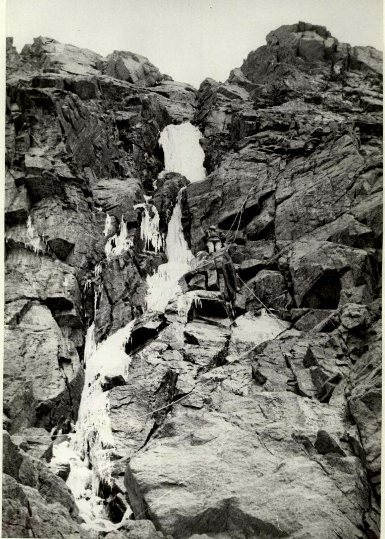
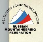
Section R8–R9. Monolithic slab with few holds, passage of the lower part using a pendulum. Climbing is very difficult.
Section R9–R11. Right along ledges 60 m to a ridge and a small platform before a narrow saddle in the ridge. The saddle is exposed to rocks and ice falling from the left wall.
Section R11–R12. Steep wall. Unstable rocks! Exit to a chimney. Seven pitons were used.
Section R12–R14. Cross the chimney to the right, exiting onto a ridge. Rocks are destroyed, iced. On the ridge, there is a convenient platform for two before a 3-meter sheer wall.
Section R14–R15. Then, up the wall and along the slab's edge to a chimney filled with ice.
Section R15–R18. Up the chimney 50 m, climbing is difficult. Right onto the wall, a small inclined ledge. The belay spot is inconvenient. Then:
- into the narrowing chimney,
- movement on abutments,
- exit left along the wall with unstable rocks onto the ridge.
A convenient platform.
Section R18–R20. 1st control tur. Then along the ridge, bypassing the 1st pinnacle on the left along ledges and short walls 120 m.
Section R20–R24. Then 130 m left of the ridge along destroyed rocks, iced. Exit onto the ridge via a wall to the right. Then along the ridge, bypassing the 2nd pinnacle on the right through an internal corner and ledges. Exit to a bivouac.
Bivouac on the summit of the rock triangle.
Section R24–R25. From the platform, a narrow destroyed rock ridge 20 m long leads to the monolithic wall of the main massif.
Section R25–R26. Then descent along a couloir in the direction of travel alongside the wall. Unstable rocks!
Section R26–R27. Along steep ice alongside the wall 150 m. It is recommended to pass early in the morning, as rockfall is possible from the left wall.
Section R27–R29.
- Up the wall 30 m. Climbing is difficult.
- Then 20 m exit along the wall to the left onto a ledge. Up to 4 people can gather.
Section R29–R32. Traverse along the ledge to the left 20 m and up along an internal corner 15 m and then along short walls to the beginning of a chimney filled with ice.
Section R32–R33. Up the wall to the right of the chimney through a cornice 25 m. Exit onto a small ledge for one person. Ladders. Work on a double rope.
Section R33–R34. Traverse to the left through the chimney. Exit onto the left wall of the chimney. Climbing is extreme.
Section R34–R35. Up the chimney wall — exit into an internal corner onto a ledge for two. From this spot, it is convenient to lift backpacks from the start of the chimney.
Section R35–R36. Right along the corner — exit onto a ledge.
Section R36–R39. Right into an ice couloir 35 m and exit onto a short ridge, leading to a ledge. Bivouac site. 3rd control tur.
Section R39–R40. From the platform, left up along a monolithic wall 50 m.
Section R40–R42. Along walls and ledges to steep inclined slabs, along slabs to the left 50 m under a wall with small ledges.
Section R42–R43. Up the wall 50 m to exit onto a ridge. Along the ridge with slabs to the summit.
Descent onto the Korzhenevskaya glacier and Surovyy pass in the Middle Talgar valley.
Section R11–R14
Section R15–R16

Section R27–R28