Ascent Log
- Sports organization: Republican Climbers' Club of the Kazakh SSR.
- Ascent classification: Technically challenging.
- Assault leader: Akinenkov M.V. — Candidate Master of Sports.
- Participants: — Belovol E.V. — 1st category, Denisov V.G. — 1st category, Popenko Yu.S. — 1st category.
- Peak name, height: "Yuzhny Talgar", 5017 m.
- Geographical area: Trans-Ili Alatau, Tian Shan.
- Route: South-West wall.
- Route height: wall section height difference — 520 m, including most challenging sections — 450 m.
- Difficulty category assessment — 5B.
- Route length: 1740 m, including wall section — 790 m.
- Route completed: August 18–21, 1968.
- Number of days: 4.
- Number of bivouacs on the route: 3.
- Total number of climbing hours: 47.
- Tactics: Movement in two teams — two on a 40-meter rope, two on a 70-meter double rope, interacting with each other. The first climber ascended without a backpack.
- Technique: During ascent, 48 rock pitons were hammered in; during descent, 5 pitons were hammered in, including: rock — 5, ice — 2.
- Average slope of the route: 65°, wall section — 85–90°, including most challenging sections 90–95°.
Historical and Geographical Overview of the Area
The western walls of the Talgar massif have long attracted climbers. In 1953, a group led by Pelevin-V. pioneered the first 5B category route to the summit of Main Talgar (5017 m). In 1958, a group led by Snesarev completed a 5B category route to the summit of Yuzhny Talgar (5000 m). Many climbing groups have since followed these routes.
Climbers ascending the western wall of Yuzhny Talgar couldn't help but notice the formidable rock walls rising to the summit to the right of Snesarev's route. The desire to tackle these walls emerged in 1966 during the ascent of "Snesarev's wall." It solidified during our traverse of the Talgar massif via the north-west wall of Yugo-Vostochny Talgar.
Three days of observing the wall and excellent photographs of the route confirmed the feasibility of this technically and tactically challenging ascent.
The weather was favorable for the climb. Unusually, it was not the typical unstable weather with frequent snowfalls; instead, there was unprecedented heat throughout July and August, likely linked to the year of highest solar activity. Glaciers were completely clear of snow. The usual traces of ice formation on the western walls of Yuzhny Talgar had disappeared. Avalanche danger was a thing of the past. However, the frequency of rockfalls increased.
The intended route was submitted for recognition as a first ascent in the Kazakh SSR.
Team Preparation
The coaching council of the club approved the following group for the chosen route:
- Akinenkov M.V. — Candidate Master of Sports, leader
- Belovol E.V. — 1st category, participant
- Denisov V.G. — —
- Popenko Yu.S. — —
All group members had experience with 5B category ascents. The group leader had participated in and led wall routes of 5B category on peaks like Yuzhny Talgar, Trud, and the 6th tower of the Corona. Members regularly trained on rocks under various weather conditions, climbing up to 350–450 m daily on difficult and very difficult terrain, wearing typical climbing attire and rubberized boots, thereby developing confidence in natural climbing conditions. The group received significant guidance on technical and tactical techniques for complex wall ascents from Kosmachev O.S.
Ascent Description
Weather conditions during the ascent were favorable.
- Light cloud cover on the first day reduced the likelihood of rockfall and ice falling from the menacing serac to the right of the upper wall section (Photo 1).
- On the 2nd and 3rd days, bright sunshine warmed the air, allowing climbing on particularly difficult sections R18–R22 (Photo 1) in galoshes, significantly easing and speeding up the passage.
As noted, the route's conditions that year were characterized by the least amount of ice formation and could be very specific.
A detailed description of the ascent is provided in Table № 1.
Assessment of the Group's Movement on the Route and Recommendations for Future Climbers
The adopted tactics proved entirely justified. All group members acted in harmony, clearly, and cohesively on the route. They were technically and physically well-prepared.
We do not recommend attempting the route in the first half of the summer due to the inevitable icing on sections 4, 16, 18, which significantly increases their difficulty, as well as the high avalanche danger at the mouths of the left and right couloirs framing the wall's base.
We draw attention to the need to minimize the time spent by the group within the couloirs, as no one is safe from ice falling from the serac. The group must act clearly and quickly to reach the rock section R2 by no later than 9:00, necessitating a departure from the bivouac under Yuzhny Talgar's western wall by no later than 6:00. Very early approaches to the couloir (at 3–4 am) are also not recommended, as we observed that during these hours in warm days, the final freezing of ice occurs, leading to increased rockfall and snow dumping from the upper slopes.
It should be noted that:
- a more or less comfortable lying-down bivouac can only be organized at the exit of section R16;
- there's a platform near section R10 (below the steep scree).
A sitting bivouac for four can be set up at the exit of section R15.
Considerations on the Classification of the Completed Route
The ascent via the south-west wall of Yuzhny Talgar undoubtedly meets the requirements of the 5B category and is technically more challenging than:
- the western wall of Yuzhny Talgar
- the wall of Trud (near the Talgar alpine camp)
- the south-west wall of the 6th tower of the Corona (near the Ala-Archa alpine camp).
GROUP LEADER: (M. Akinenkov)
Description of the Ascent on the South-West Wall of Yuzhny Talgar
(Photo 1 taken from a gendarme on the North-West wall of Yugo-Vostochny Talgar)
Wall height: 500–520 m (from R1 to R28 section)
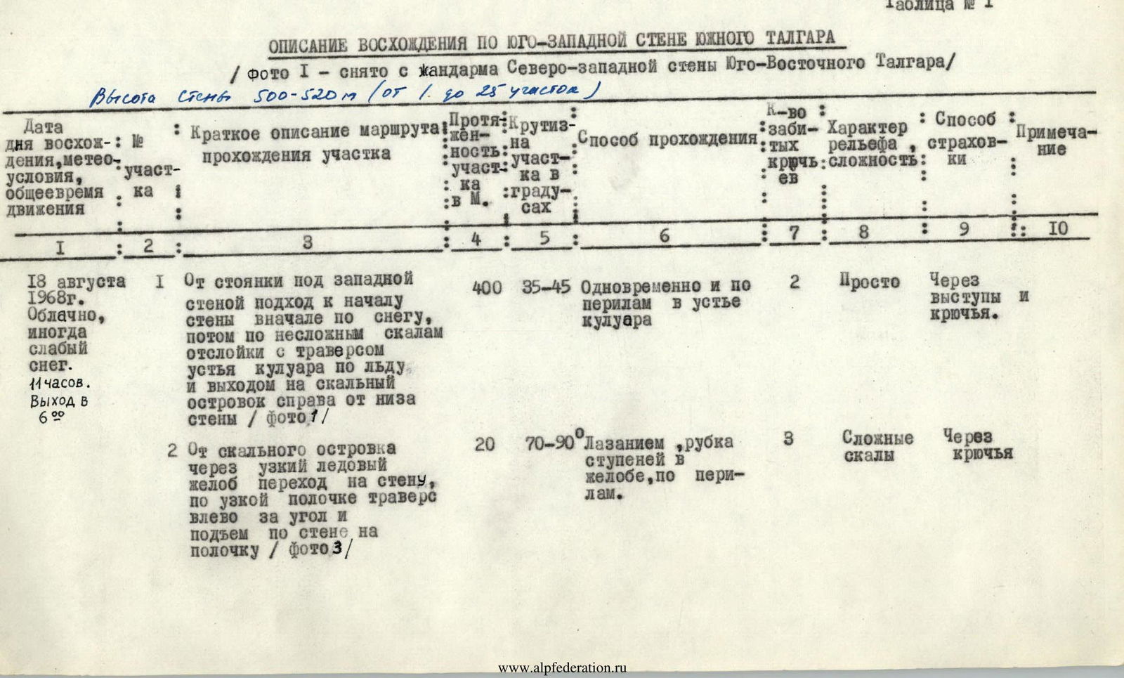

| Section № | Brief description of the route / section passage | Section length in m | Section steepness in degrees | Passage method | Number of pitons driven | Terrain character, difficulty | Belay method | Notes |
|---|---|---|---|---|---|---|---|---|
| August 18, 1968. Cloudy, occasional light snow. 11:00. Departure at 6:00. | ||||||||
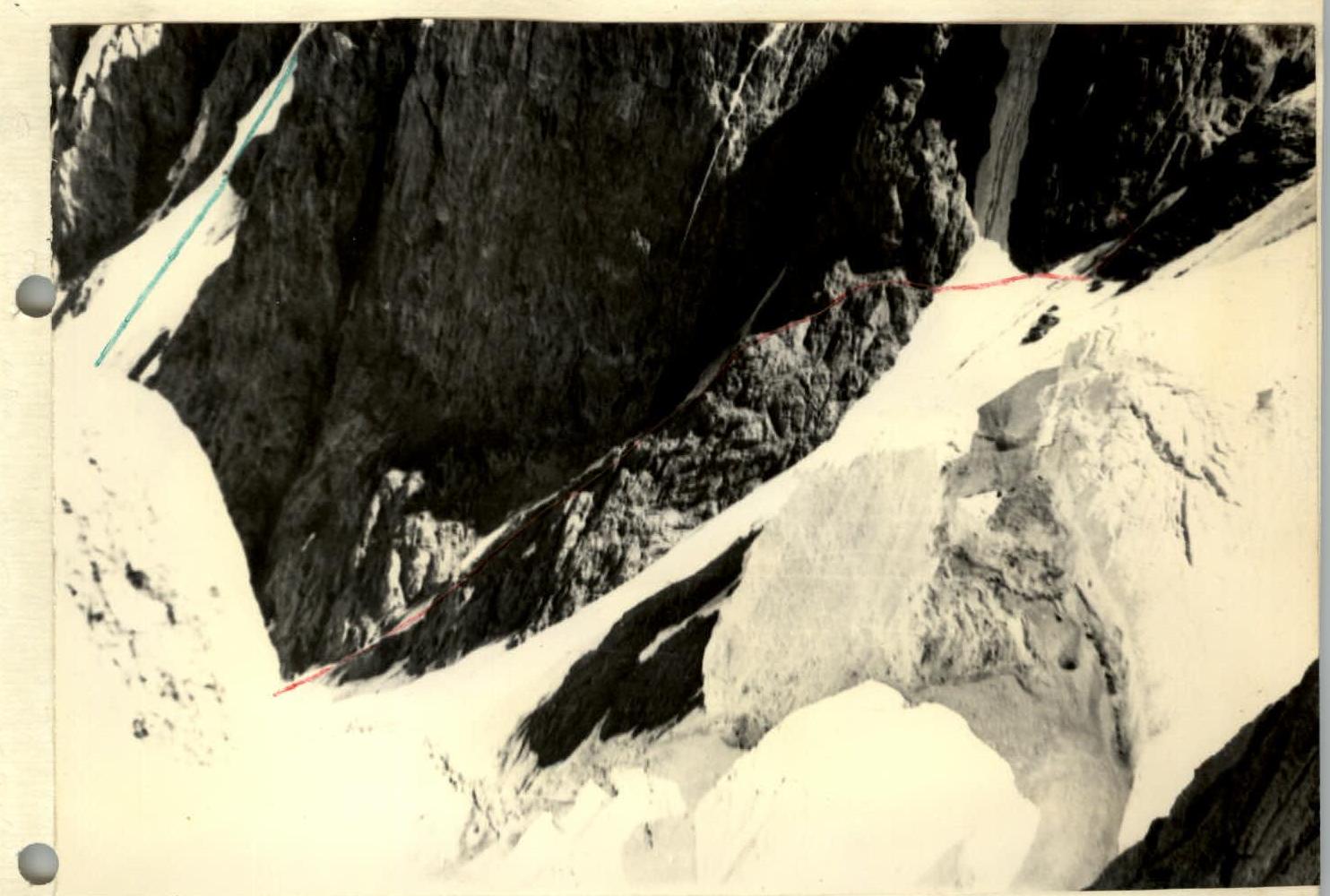
| R1 | From the bivouac under the western wall, approach to the wall's base initially on snow, then on simple rocks, traversing the couloir's mouth on ice, and exiting to a rocky outcrop to the right of the wall's base (Photo 2) | 400 | 35–45 | Simultaneous and on fixed ropes in the couloir's mouth | 2 | Simple | Through ledges and pitons. | |
| R2 | From the rocky outcrop through a narrow ice gully, transition to the wall, along a narrow ledge traversing left around the corner, and ascent up the wall to a ledge (Photo 3) | 20 | 70–90 | Climbing, chopping steps in the gully, on fixed ropes. | 3 | Challenging rocks | Through pitons | |
| R3 | Up a crack and internal corner, exiting to a ledge. Control cairn № 1 | 60 | 65–75 | Climbing, on fixed ropes. | 3 | Rocks, moderate difficulty | Through pitons and ledges. | |
| R4 | Up a monolithic wall to the right of the ice formation, transitioning into a corner and bypassing a "plug" on the right (Photo 4) | 45–50 | 85–75 | Challenging climbing on fixed ropes. | 4 | Challenging rocks. | Through pitons | At the beginning of the year, ice will cover most of the corner |
| R5 | Traverse the internal corner left and ascend a short, challenging wall to a rock shelf — a ledge. | 25 | 85–90 | — | 3 | Challenging rocks, | — | |
| R6–R7 | Up a vertical internal corner (Photo 5) with smooth monolithic walls, exiting to a ledge. Control cairn № 2. | 65 | 80–90 | First 30 m — very challenging climbing with ladder placement in two locations. Next 30 m — challenging and moderate difficulty | 10 | Very challenging, challenging, and moderate | — | On the continuation of the ledge to the right, there's a good bivouac site. Bivouac. |

| Section № | Brief description of the route / section passage | Section length in m | Section steepness in degrees | Passage method | Number of pitons driven | Terrain character, difficulty | Belay method | Notes |
|---|---|---|---|---|---|---|---|---|
| August 19, 1968. Clear. 10:00. Departure at 8:30. | ||||||||
| R8 | On the left side of kedge on simple rocks, approach to the gendarme | 80 | 35–40 | Simultaneously | — | Simple rocks | Through ledges. | |
| R9 | Ascent via a crack and bypassing the gendarme on the right | 20 | 65–75 | Climbing with belaying. | — | Rocks of moderate difficulty | — | |
| R10 | Traverse right on snow and scree under the ridge's wall. | 40 | 10–15 | Simultaneously | — | Snow, scree | — | |
| R11 | Up monolithic rocks, exiting to the ridge | 40 | 70 | Climbing with belaying. | 2 | Rocks of moderate difficulty | Through pitons and ledges. | |
| R12 | Up a vertical, monolithic, challenging wall (4 m), then along the ridge | 40 | 40–65 | Climbing, on fixed ropes. | 2 | Initially challenging, monolithic rocks, then moderate difficulty | — |

| Section № | Brief description of the route / section passage | Section length in m | Section steepness in degrees | Passage method | Number of pitons driven | Terrain character, difficulty | Belay method | Notes |
|---|---|---|---|---|---|---|---|---|
| R13 | Along a sharp, monolithic ridge crest, exiting to a ledge under the gendarme's wall (Photo 9) | 20 | 10, 90 | Challenging climbing, on fixed ropes | 3 | Challenging rocks | Through pitons and ledges. | |
| R14 | Along the ledge, traverse right down, then around the corner on the wall with a transition into a couloir (Photo 9) | 20 | 75–90 | Challenging climbing, on fixed ropes | 3 | — " — | Through pitons. | |
| R15 | Left of the serac, up rocks along the ice to a bridge | 40 | 90, 65 | Climbing with belaying. | 1 | Rocks of moderate difficulty. | Through ledges and a piton. | In the first half of the summer — very challenging due to ice |
| R16 | Up an internal corner (Photo 9) | 40 | 90–75 | Very challenging climbing. One ladder is hung. | 3 | Very challenging rocks with holds facing down. Few cracks. Upper part heavily destroyed. | Through pitons. | In the first half of the summer, water flows through the corner, and there will be ice formation. Above the corner, a "bowl" with remnants of snow and ice. |
| R17 | Approach to monolithic slabs along destroyed rocks. | 15 | 30 | Simultaneously | — | — | — |

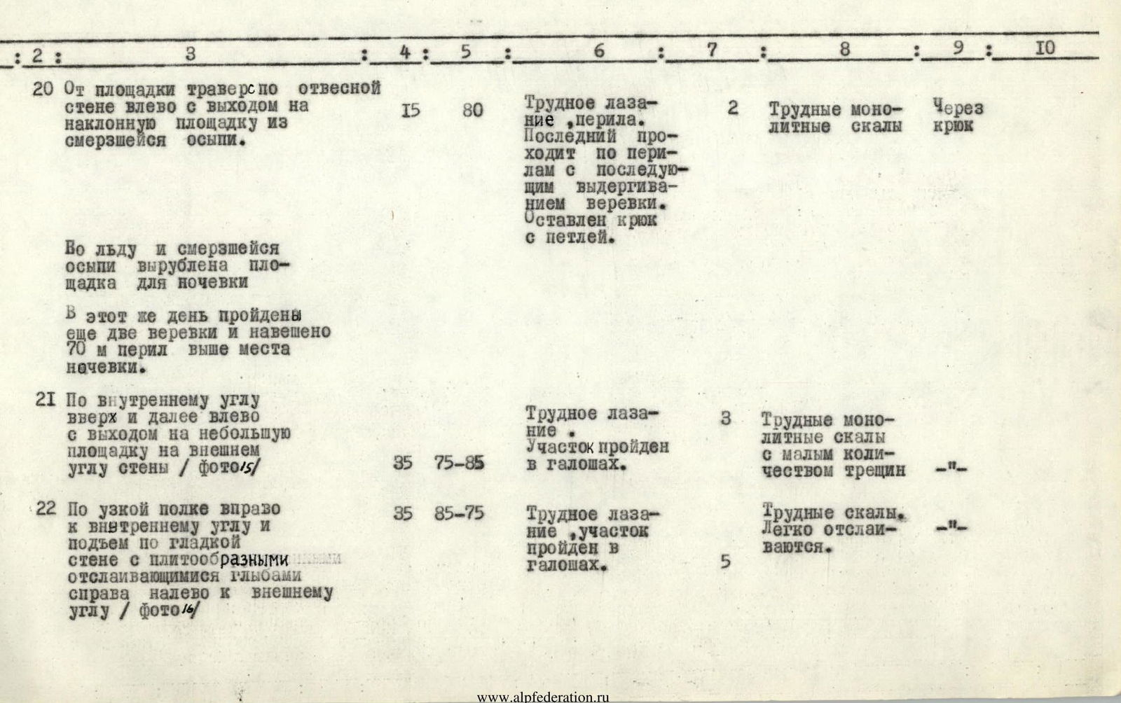
| Section № | Brief description of the route / section passage | Section length in m | Section steepness in degrees | Passage method | Number of pitons driven | Terrain character, difficulty | Belay method | Notes |
|---|---|---|---|---|---|---|---|---|
| R18 | Up slabs to a rock overhang (3 m), overcoming it with ladders using a diagonal crack, up-right, then right and up, using a ladder — exiting to an inclined slab (Photo 12, 13) | 35 | 65, 105, 70, 90, 30 | Very challenging climbing with ladder use. Rappel for backpacks. Section completed in galoshes | 8 | Very challenging monolithic rocks with few holds and cracks. | Through pitons | In the first half of the summer and in snowy years, the exit to the slab will be iced over from the snow collection area above the wall. A piton will be required. |
| R19 | Right along the slab, exiting through a short wall (3 m) to an upper inclined platform. | 20 | 70, 30 | Climbing with belaying. | 2 | Rocks of moderate difficulty, with loose rocks on top. | — |
Exiting through a narrow, converging rock passage in the monolithic wall to the ridge is more challenging (Photo 14) and is blocked by smooth walls with a negative slope to the right, making their traverse impossible. Our variant is simpler and preferable, given the presence of a bivouac platform.


| Section № | Brief description of the route / section passage | Section length in m | Section steepness in degrees | Passage method | Number of pitons driven | Terrain character, difficulty | Belay method | Notes |
|---|---|---|---|---|---|---|---|---|
| R20 | From the platform, traverse along an overhanging wall left, exiting to an inclined platform of frozen scree. | 15 | 80 | Challenging climbing, fixed ropes. The last climber descends on fixed ropes with subsequent rope retrieval. A piton with a loop is left. | 2 | Challenging monolithic rocks | Through a piton | On the same day, sections R21 and R22 were completed on fixed ropes, and 70 m of fixed ropes were set up above the bivouac site. |
| R21 | Up an internal corner and then left, exiting to a small platform on the wall's outer corner (Photo 15) | 35 | 75–85 | Challenging climbing. Section completed in galoshes. | 3 | Challenging monolithic rocks with few cracks | — | |
| R22 | Along a narrow ledge right to an internal corner and ascent up a smooth wall with slab-like layers on the right, left to the outer corner (Photo 16) | 35 | 85–75 | Challenging climbing, section completed in galoshes. | 5 | Challenging rocks. Easily detaching. | — | |
| August 20, 1968. Clear, cold, strong cold wind at the summit. 11:00. Departure at 8:30. | ||||||||
| R21–R22 | Sections R21 and R22 completed on previously set fixed ropes. | — | — | — | — | — | — | |
| R23 | Up challenging, destroyed rocks (3 m), exiting to an oblique ledge. Control cairn № 3 is built here. Along the ledge right to the internal corner and up (12 m) — exiting to a sharp ridge and traverse right along an overhanging wall (5 m) to a ledge (Photo 17) | 30 | 80, 70, 85 | Challenging climbing, fixed ropes. | 5 | Initially challenging, destroyed rocks, then moderate difficulty, and from the ridge to the ledge — challenging rocks, partially destroyed | Through pitons | |
| R24 | Up the ridge, exiting to the summit of the "pennant" | 25 | 80, 65 | Initially challenging, then moderate climbing. Fixed ropes | 1 | Challenging and moderate difficulty monolithic rocks | — | |
| R24–R25 | Descent along an overhanging wall into a "saddle". | 10 | 90 | Rappel | 2 | — | — | |
| August 21, 1968. Strong wind, cold, snow towards the end of the day. Descent from the summit. | ||||||||
| R25 | Bypass the next "pennant" on the left along the wall and exit to a simple ridge | 15 | 75–85 | Challenging climbing | 1 | Monolithic rocks | Through a piton and ledges | |
| R26–R28 | From section R25, exit to the ridge on rocks embedded in ice and then along the ridge to the summit. | 150–450 | 30–60 | Simultaneously, with belaying, partially on fixed ropes. First climber on crampons | — | Rock-ice terrain; firn, ice | Through ledges and ice axe | A note from the Estonian club "Firi" climbers was found. Bivouac organized in a gully on the ridge to the right of the summit. Descent made via the summit of Main Talgar due to high rockfall danger in the couloir leading to the "saddle". |
Orographic Scheme of the Talgar Area

Approach to the Route's Start
 Group's path
Snesarev's group path, 5B category.
Group's path
Snesarev's group path, 5B category.


