I. Climbing category — technical
- Climbing area — Tian Shan, Trans-Ili Alatau ridge
- Peak — traverse with ascent via the left glacial couloir of the Western wall of Glavny Talgara — South Talgar
- height — 4973 m
- route type — ice-snow
- Estimated difficulty category — 4B
- Route characteristics:
- height difference — 1000 m
- length of sections 4–5 difficulty category — 580 m
- average steepness of the route — 50°
- Pitons used:
- rock — none
- ice screws — 55 pcs
- bolt pitons — none
- chock stones — none
- Total climbing hours — 14.5 h
- Number of bivouacs — none
- Surname, name, patronymic of the leader, participants, their qualification:
Antishin Andrey P. — leader, 1st sports category. Zolnikova Lyudmila I. —
participant, 1st sports category. Beisenbaev Karat T. — participant, 2nd sports category. Aktaev Seva B. — participant, 2nd sports category. Nedoboyko Mikhail V. — participant, 2nd sports category.
10. Team coach — Fischer I.I.
11. Date of departure on the route August 16, 1988 — 06:30. Date of return from the route August 16, 1988 — 21:00.
12. Organization — AUSB "Talgar"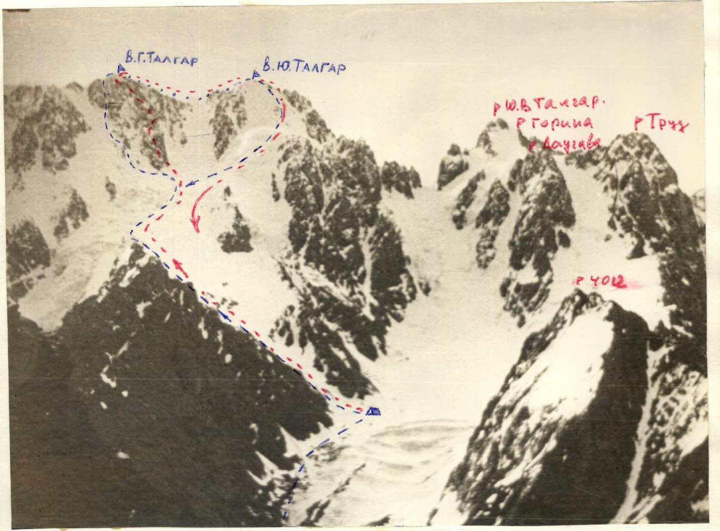
General view of the ascent. Panorama of the area
General view

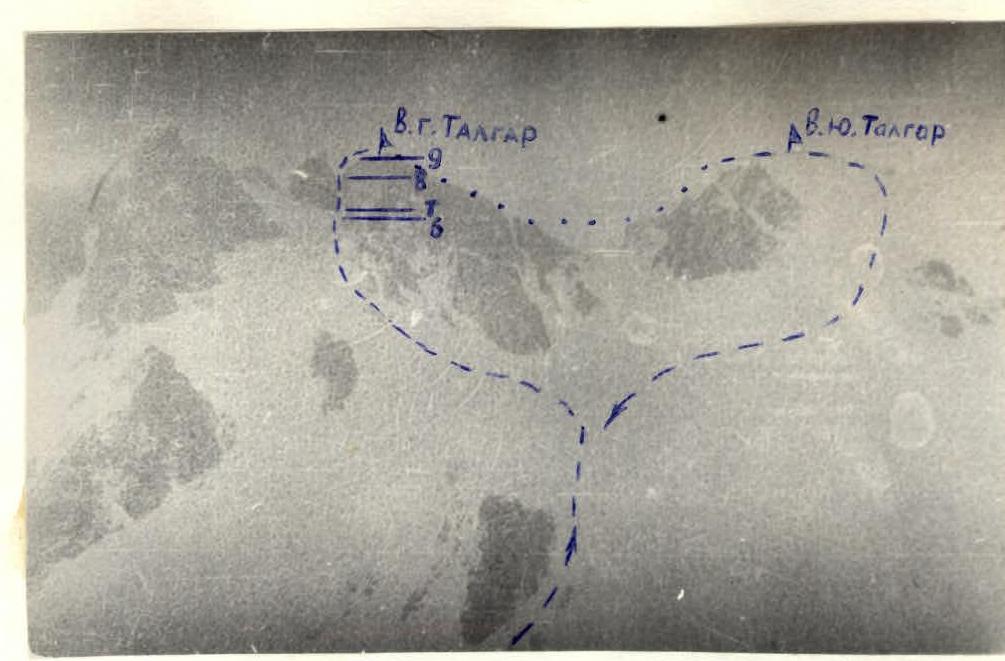
View of the route after passing the first "cushion".
Approach to the route: From the AUSB "Talgar" branch, go up the trail along the gorge to the moraine of the South Talgar glacier. Then turn off the trail to the left and go along the left side of the glacier moraine. The trail leads to overnight stays on the moraine of the glacier under the spur counterfort extending from the South Talgar peak. The approach from the camp takes 4–5 h.
From the overnight stays, start the ascent:
- along the couloir to the left upwards to the spur.
Here is the start of the route. The beginning coincides with the start of the Baranovsky route, 4A category.
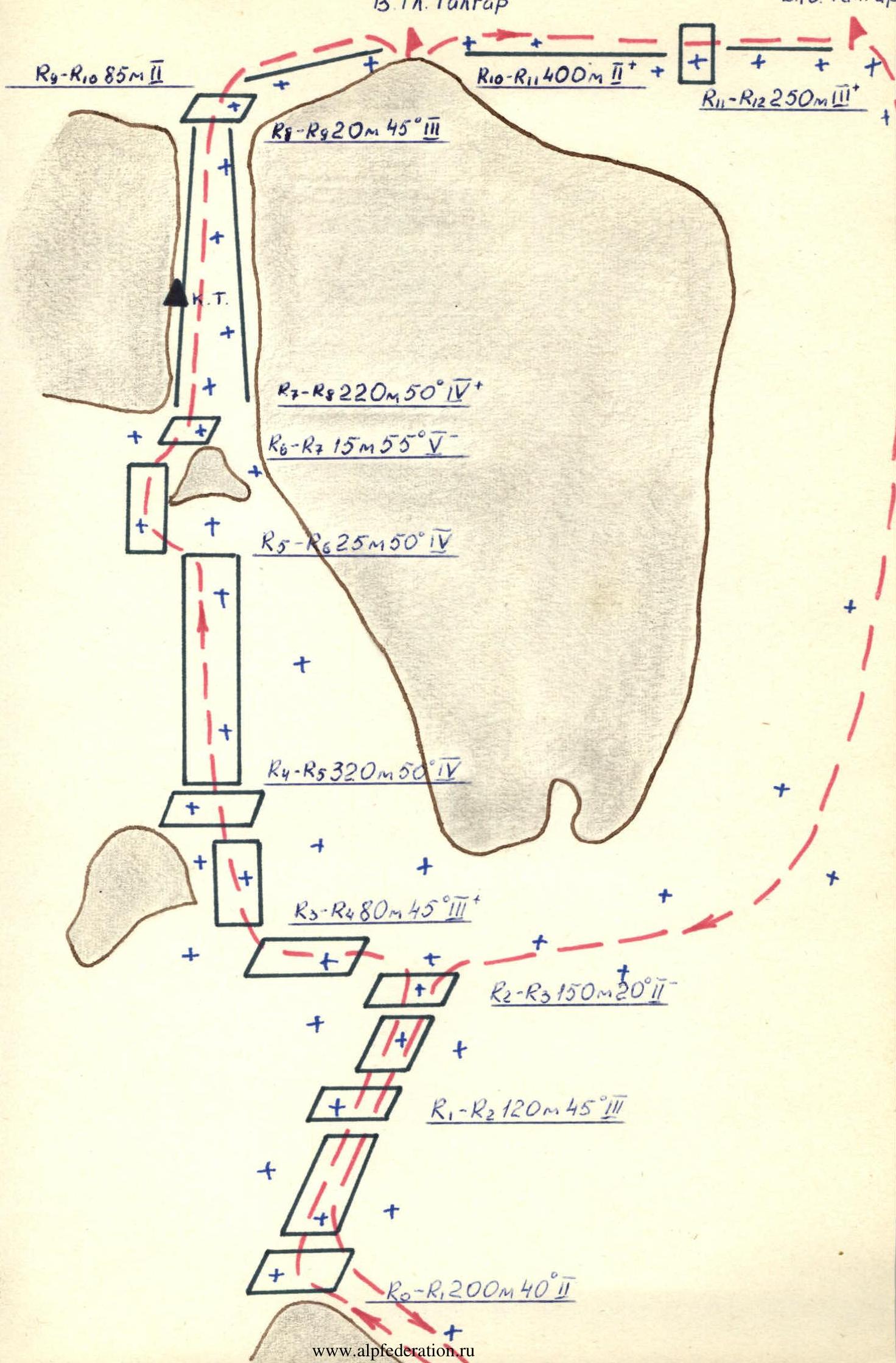
Brief explanation of the diagram
R0–R1. The section is an ice slope with a slight steepness. At the end — a small flattening.
R1–R2. In this section, the steepness of the slope increases somewhat. Ice screws are necessary.
R2–R3. Having passed the first "cushion," turn left and approach the snow-ice slope. Move straight up towards the rock island, leaving it on the left side. On the right side remains the rock massif of the western wall with the Yastrebkov route, 4B category, on Glavny Talgar.
R3–R4. Having passed 2 ropes, reach the upper part of the rock island.
R4–R5. From here — straight up. Having passed about 9 ropes, rise to a small rocky outcrop.
R5–R6. The island is bypassed on the left side. Behind it is a small snow-ice ridge, about 2–3 m long, connecting this island to the rocks. At this point, all participants can gather.
R6–R7. The beginning of the entrance to the couloir requires careful passage. Ice formation.
R7–R8. Movement along the couloir goes along the left part. After two ropes on the wall, a control cairn. Then move again on the left side and enter the narrowest part of the couloir, about 3 m wide. Caution, ice formation. This is the key section of the route. After 80 m, the couloir ends and leads to a snow slope.
R8–R9. The snow slope is gentle at first. At the end, it ends with a sharp rise. Belay with an ice axe.
R9–R10. The section passing along the snow ridge leads to the Glavny Talgar peak.
R10–R11. Further, from the Glavny Talgar peak, the path goes along the snow ridge. It is necessary to move as low as possible above the upper part of the ridge, as snow-ice cornices stretch along the entire length to the exit to the South Talgar peak.
R11–R12. On the way, there are difficult sections that are passed with thorough belay through ice axes.
R0–R9. Throughout the entire main route, thorough belay with ice screws is necessary. On the key section R7–R8, it is advisable to use rope protection. When passing the main part of the route and until exiting the couloir, there is nowhere to make a bivouac. During the entire ascent, there were no cases of falling stones. No traces on the snow and ice from falling stones were observed. The weather during the traverse was sunny and clear.
Brief information about the descent
The descent from the South Talgar peak goes along its western snow-ice slope onto the South Talgar glacier, via the Baranovsky route, 4A category.