Minutes of the Uzelskaya Classification Commission Meeting
July 29, 1978
Talgar Alpine Camp
The Uzelskaya Classification Commission, appointed by the authorized Sports Committee of the USSR for the Tian-Shan region, Comrade R.P. Stroganov (order No. 6 dated July 28, 1978), consisting of:
- V.N. Zapeka — senior instructor, Master of Sports — Chairman of the Commission
- A.V. Kelberg — senior instructor, Master of Sports — member of the commission
- E.L. Vardanov — senior instructor, Candidate for Master of Sports — member
- V.A. Ganyalin — senior instructor, Candidate for Master of Sports — member
- V.I. Shabrukov — instructor, 1st sports category — member
The commission reviewed the material on the first ascent by a group of instructors from the Talgar Alpine Camp via the western ridge of the peak Sportivnaya: a) route sheet; b) minutes of the ascent debriefing; c) report on the first ascent of the route.
The commission considers that the route taken by the group is logical in terms of complexity and length, as well as the arsenal of mountaineering techniques used, corresponding to category 4A.
The ascent to peak Sportivnaya on July 16, 1978, via the western ridge is considered a first ascent of this route.
Chairman of the Classification Commission
Members of the Commission:
November 16, 1978: V. Ganyalin, P. Arakcheev, A. Kuznetsov, S. Sinjakov. 700 m, 20 m, 40°, 14:00, 2 hours, 11 hours.
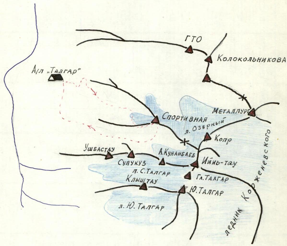
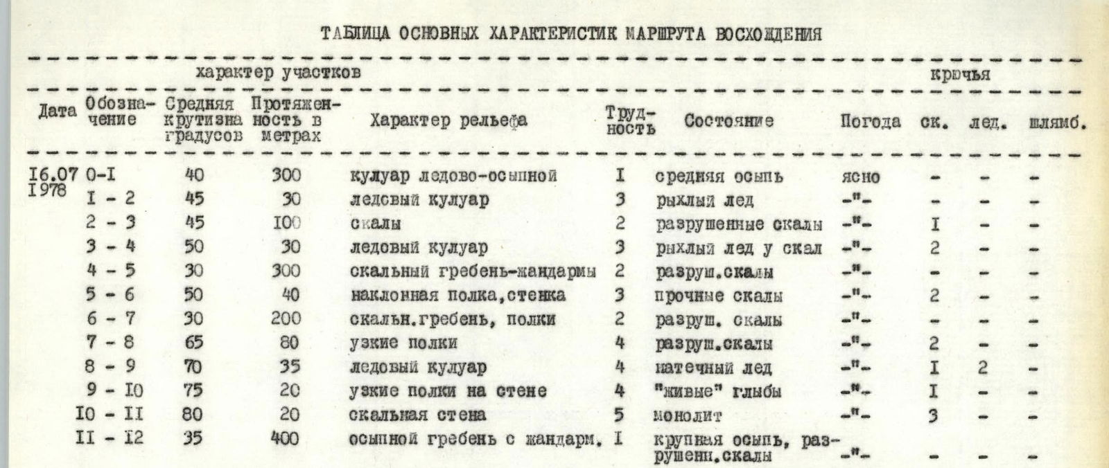
Map-scheme of the ascent area. Table of main route characteristics
Description of approaches to the route
Peak Sportivnaya is located in a short lateral spur of the Trans-Ili Alatau range, branching off in a westerly direction in the area of peaks Kopr and Iiyin-Tau. The peak is in close proximity to the Talgar camp.
From the camp, follow a steep trail east towards the upper training rocks of the Ozerny glacier. Pass the training rocks to the right and move onto the moraine of the glacier flowing from the northwest slope of peak Sportivnaya. Moving along the moraine, staying near its middle part, approach the glacier tongue. From here, a fairly wide couloir is visible on the western ridge, covered on the left by ice boards flowing down from the walls. A distinctive feature of this couloir is a stream running along the boundary between the ice and the talus.
The journey from the camp to the foot of the couloir takes 2 hours and 30 minutes.
Brief explanation of the route table
Ascent through the couloir:
- Initially, it goes through the middle talus, then through slushy snow and ice crust.
- In the middle part — cross the couloir on the ice, exit onto the rocks on the right (in the direction of travel) side of the couloir, as spontaneous stones fall from the left wall of the couloir onto the ice.
- The upper part of the couloir (section R3–R4) — proceed along the edge of the ice along the rocky wall with piton placement into the rock.
The rocky tower at the end of section R6–R7 is bypassed on the left via ledges with piton protection; behind the tower, a steep descent into a depression, after which the main technical difficulties of the route begin. Two powerful sheer gendarmes are bypassed along steep narrow ledges (section R7–R8) to a narrow ice saddle with rocks. Here is the second control point.
Above the saddle looms a powerful wall with negative sections. A rope loop is hung on the saddle, with the help of which a descent is made along the edge of the formed ice of the couloir, going to the left; to the right — sheer drops of 250–300 m.
After descending 15 m, it is necessary to:
- traverse along the steep ice of the couloir to a large rocky outcrop near the rusty overhanging wall.
Careful protection and great caution are necessary here.
Further:
- traverse along narrow unreliable ledges along the wall to sections of monolithic rocks (section R9–R10).
20 m from the rocky outcrop, there is an inclined platform that can accommodate two people and allow for reliable piton protection.
From this platform, a vertical ascent up the wall of monolithic rocks for 20 m involves technically complex climbing to the ridge (section R10–R11).
Further, a straightforward ridge leads to the summit. Descent is via a category 1 route towards the Kopr glacier to the Rakhimov campsite.


