Ascent Passport
- Ascent class — rock climbing.
- Ascent area — Trans-Ili Alatau.
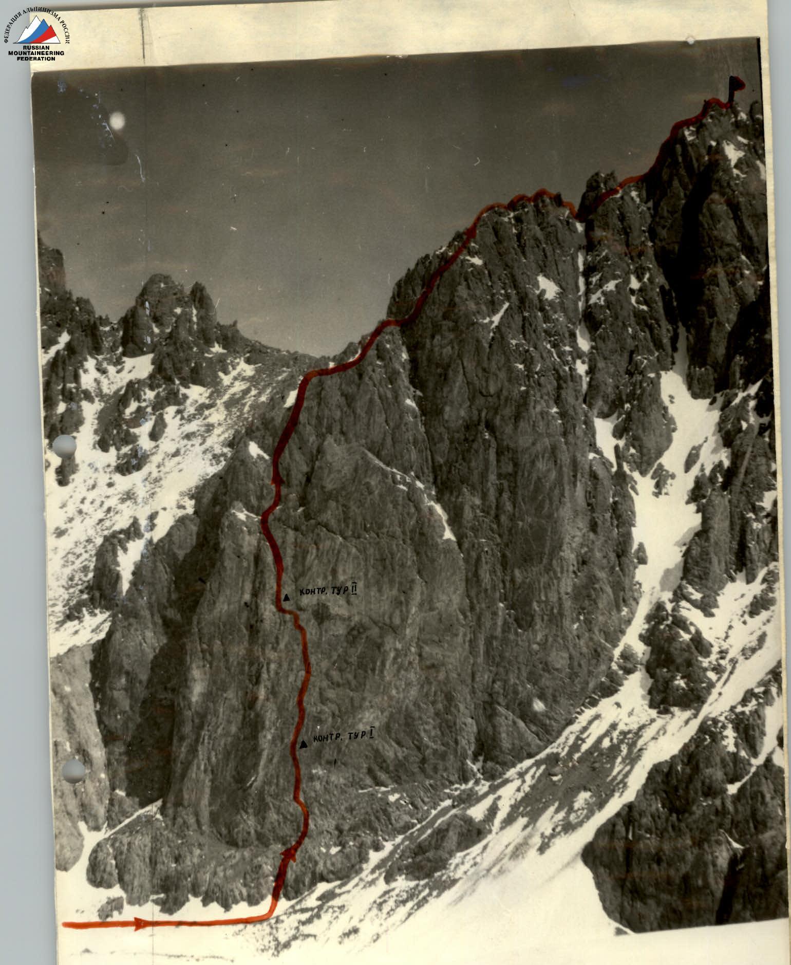
- Peak, its height, ascent route: p. Pioneer, 4050 m, via the southern wall.
- Proposed difficulty category — 4B.
- Route characteristics: a) wall height difference — 275 m; b) section lengths: 2 — 30 m; 3 — 445 m; 4 — 115 m; 5 — 92 m; c) average wall steepness — 68°.
- Pitons hammered: for belaying, for creating intermediate belays, rock pitons — 33, bolt pitons — 4, chocks — 6.
- Total climbing hours — 7 h 20 min.
- Number of overnight stays — none.
- Full name of the leader, participants, and their qualifications:
- Smirnov Vadim Anatolyevich MCMSK — leader
- Khalitov Zinnur Shagabutdinovich 1st sports category — participant
- Agishev Ramazan Gazizovich 1st sports category — participant
- Bukreev Anatoly Nikolayevich 1st sports category — participant
- Team coach: Honored coach of the USSR, Master of Sports Ilyinsky E.T.
- Date of departure for the route and return: June 19, 1980
NOTE:
Photo 1. Route of the SCA SAVO team via the center of the southern wall of p. Pioneer (Trans-Ili Alatau) 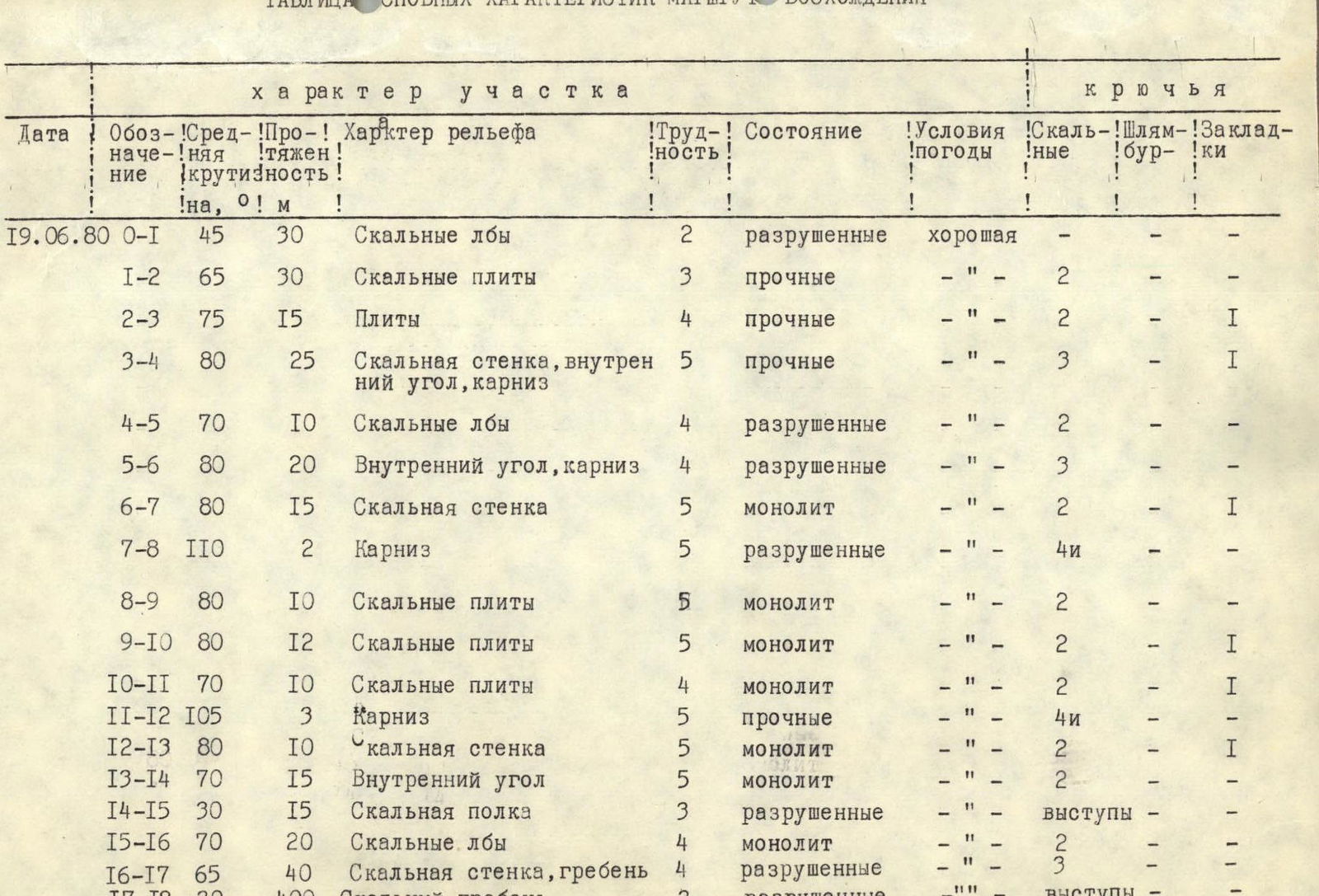
Table of Main Characteristics of the Ascent Route
| Date | Section | Steepness, ° | Length, m | Terrain characteristics | Difficulty category of section | Condition | Weather | Rock pitons | Bolt pitons | Chocks |
|---|---|---|---|---|---|---|---|---|---|---|
| June 19, 1980 | R0–R1 | 45 | 30 | Rocky brows | 2 | destroyed | good | |||
| R1–R2 | 65 | 30 | Rocky slabs | 3 | solid | " | 2 | |||
| R2–R3 | 75 | 15 | Slabs | 4 | solid | " | 2 | 1 | ||
| R3–R4 | 80 | 25 | Rocky wall, inner corner, overhang | 5 | solid | " | 3 | 1 | ||
| R4–R5 | 70 | 10 | Rocky brows | 4 | destroyed | " | 2 | |||
| R5–R6 | 80 | 20 | Inner corner, overhang | 4 | destroyed | " | 3 | |||
| R6–R7 | 80 | 15 | Rocky wall | 5 | monolithic | " | 2 | 1 | ||
| R7–R8 | 110 | 2 | Overhang | 5 | destroyed | " | 4 | |||
| R8–R9 | 80 | 10 | Rocky slabs | 5 | monolithic | " | 2 | |||
| R9–R10 | 80 | 12 | Rocky slabs | 5 | monolithic | " | 2 | 1 | ||
| R10–R11 | 70 | 10 | Rocky slabs | 4 | monolithic | " | 2 | 1 | ||
| R11–R12 | 105 | 3 | Overhang | 5 | solid | " | 4 | |||
| R12–R13 | 80 | 10 | Rocky wall | 5 | monolithic | " | 2 | 1 | ||
| R13–R14 | 70 | 15 | Inner corner | 5 | monolithic | 2 | ||||
| R14–R15 | 30 | 15 | Rocky ledge | 3 | destroyed | " | ledges | |||
| R15–R16 | 70 | 20 | Rocky brows | 4 | monolithic | " | 2 | |||
| R16–R17 | 65 | 40 | Rocky wall, ridge | 4 | destroyed | " | 3 | |||
| R17–R18 | 30 | 400 | Rocky ridge | 3 | destroyed | " | ledges |
Explanatory Notes to the Table
Departed from "Tuyuk-su" base at 7:00. Arrived under the route at 9:00. Began the route at 9:40. Approach to the route via scree ledges and easy rocks. The first rope (R0–R1) via the inner corner and rocky brows. Reach a convenient ledge. Traverse monolithic slabs left to the inner corner. Pass a small overhang directly upwards and via the inner corner under the overhang. Traverse the overhang left and exit onto a small ledge via slabs (1st control point). From it, move right-up towards the ledge. From it, left-up via the inner corner (R5–R6) and through a small (0.5 m) overhang onto a ledge. From the ledge, move right-up under the overhang (2 m). The overhang is passed directly upwards. Further via slabs with few holds to a large overhang. Traverse under it left (R9–R10) to a ledge (2nd control point). From it, traverse left into the inner corner. Slabs with small holds. Via the inner corner, approach under the overhang (3 m). Pass it directly upwards. Further via the rocky wall and transition left into the inner corner. Via it (R13–R14) upwards to a scree ledge. Further via brows (R14–R15), slightly moving left. Reach the ridge; the rocks are heavily destroyed. Along it to the summit. At the summit at 17:00. Descent via the 1B category difficulty route to Pioneer Pass.