Northern Tien Shan, Trans-Ili Alatau
Peak Pioneer
via the right part of the South Face
4A cat. diff.
Ascent Passport
- Region, gorge, section number according to the classification table of 20_year — Northern Tien Shan, Trans-Ili Alatau, Maloe Almatinskoe gorge.
- Name of the summit, its height, name of the route: Peak Pioneer 4031 m, via the right edge of the South Face
- Proposed: 4A cat. diff.
- Nature of the route: rock
- Height difference of the route: 360 m
Length of the route: 550 m. Length of sections:
- V cat. diff. — 10 m. Average steepness:
- main part of the route — 70°
- entire route — 50°
- Pitons left on the route:
Total 10; including bolted — 3
- Team's travel hours: 6 hours
- Leader: Yuri Gorbunov, Master of Sports
Team members:
- Coach: Ilyinsky E.T., Honored Coach of the Republic
- Exit to the route from Base Camp: hour, day, month, year
Route started: « », « », « », « » Reached the summit: « », « », « », « » Returned to Base Camp: « », « », « », « » Descent from the summit: via route 1B cat. diff. to Pioneer Pass;
-
Organization: CSKA MO RK
-
Responsible for the report K. Belotserkovsky
Email and phone k.belotserkovskiy@gmail.com, +7 701 736-18-87
Map of the area General photo
of the wall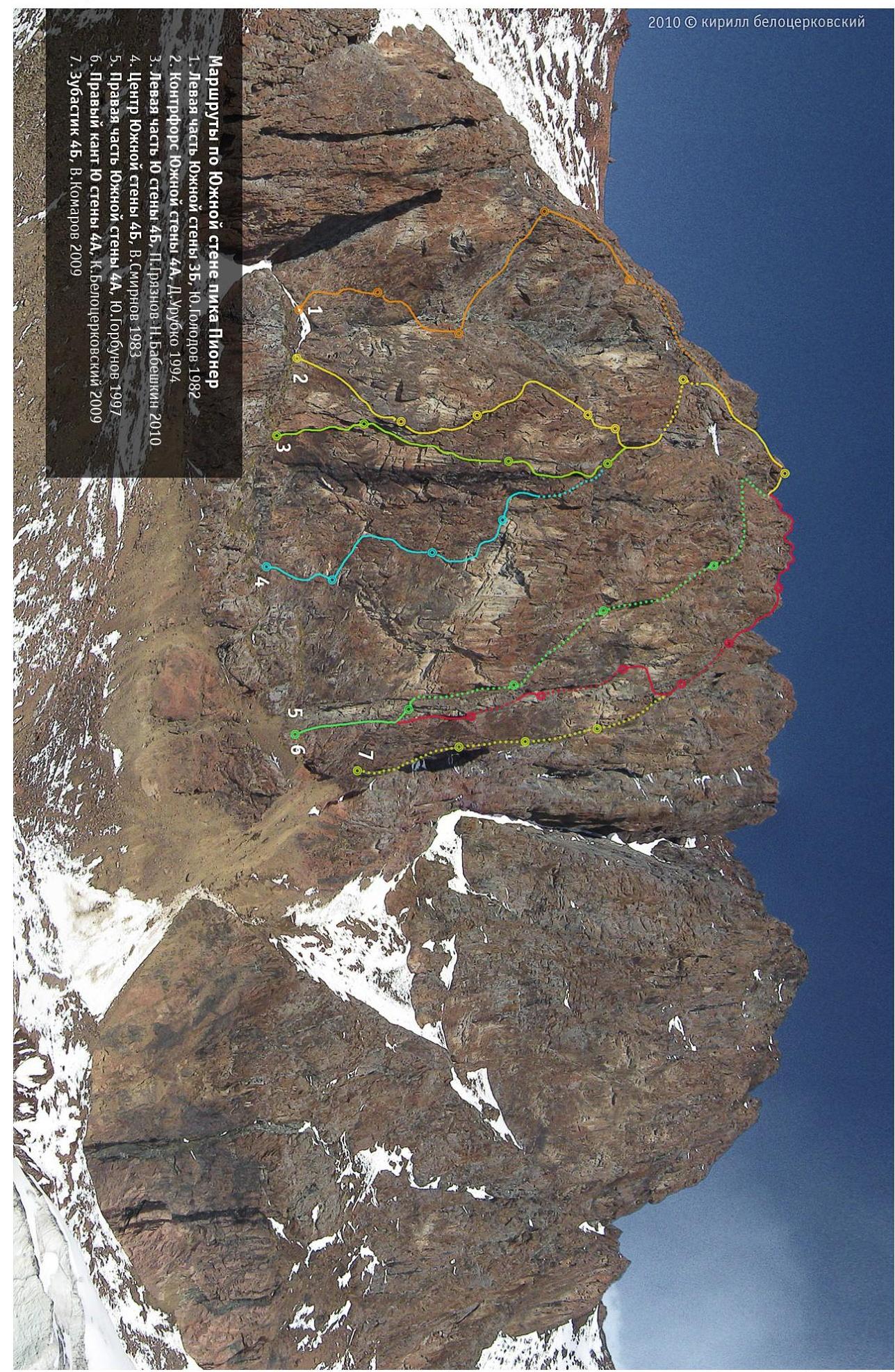
Route Diagram
Peak Pioneer. Right part of the South Face 4A cat. diff. Yu. Gorbunov.
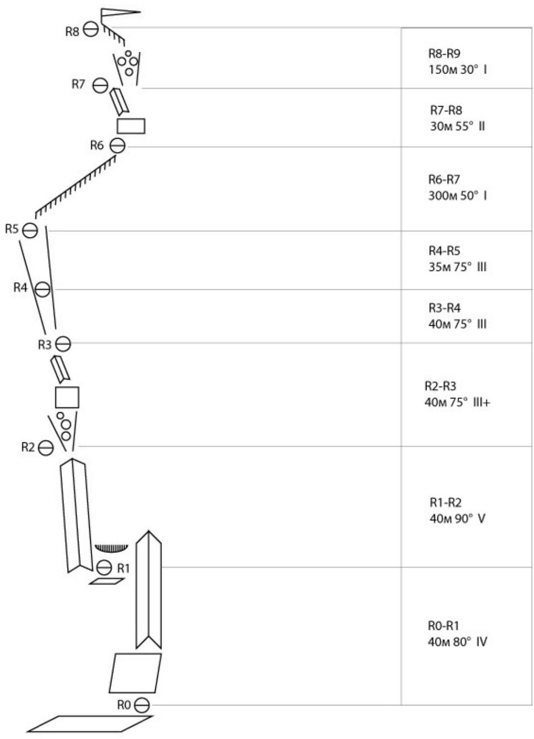
Description.
R0–R1
Start from a ledge with a cross. Ascend a gentle wall upwards. After 30 m, move left through an internal corner into a rock niche. There is a belay station on two bolted pitons.
R1–R2
From the belay station, traverse left into an internal corner. Move up the corner until you reach a scree-filled couloir. Belay station on a large separate boulder.
R2–R3
From the belay station, ascend a steep couloir interrupted by rock walls. The walls of the corner may be wet (depending on the time of year).
R3–R4
Move along a steep couloir with walls.
R4–R5
Continue moving along the couloir. The section ends on a large scree-filled ledge, where all routes on the south face converge.
Enter a steep rock couloir in the upper part of the ledge and ascend it until you reach the ridge. Then follow the ridge to the start of route 1B. A prepared rope team takes 25–30 minutes. The ridge leads to a large scree-filled couloir, which you need to ascend to the start of route 1B cat. diff., and then follow it to the summit.
Descent is via route 1B and then to Pioneer Pass.