North Tien Shan, Zailiyskiy Alatau
Peak Pioner
via the central buttress of the South Face
4A cat. dif.
Ascent Passport
- Region, gorge, section number according to the classification table of 20_ year — North Tien Shan, Zailiyskiy Alatau, Maloye Almatinskoye gorge.
- Name of the summit, its height, name of the route: Peak Pioner 4031 m, via the central buttress of the South Face
- Proposed: 4A cat. dif.
- Nature of the route: rock
- Height difference of the route: 360 m
Route length: 550 m. Length of sections: cat. dif. 5B — 10 m. Average steepness: main part of the route — 70°; entire route — 50°
- Pitons left on the route:
total 10; including bolted — 1
- Team's travel hours: 8 hours
- Leader: surname, name, sports rank
Urubko Denis, MSМК. Participants:
- Coach: Ilyinsky E.T., ZTR
- Exit to the route from BL: hour, day, month, year
Route started: « », « », « », « » Reach the summit: « », « », « », « » Return to BL: « », « », « », « » Descent from the summit: via route 1B cat. dif. to Pioner Pass;
-
Organization: CSKA MO RK
-
Responsible for the report K. Belotserkovsky
Email and phone: k.belotserkovskiy@gmail.com, +7 701 736-18-87
Map of the area
General photo
of the wall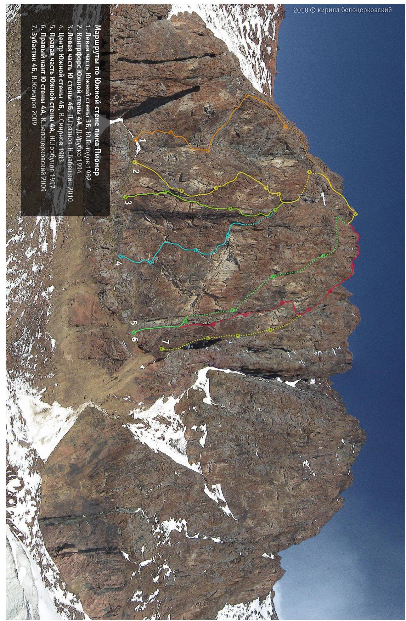
Diagram
Peak Pioner. Buttress of the South Face 4A. D.
Urubko, 1993.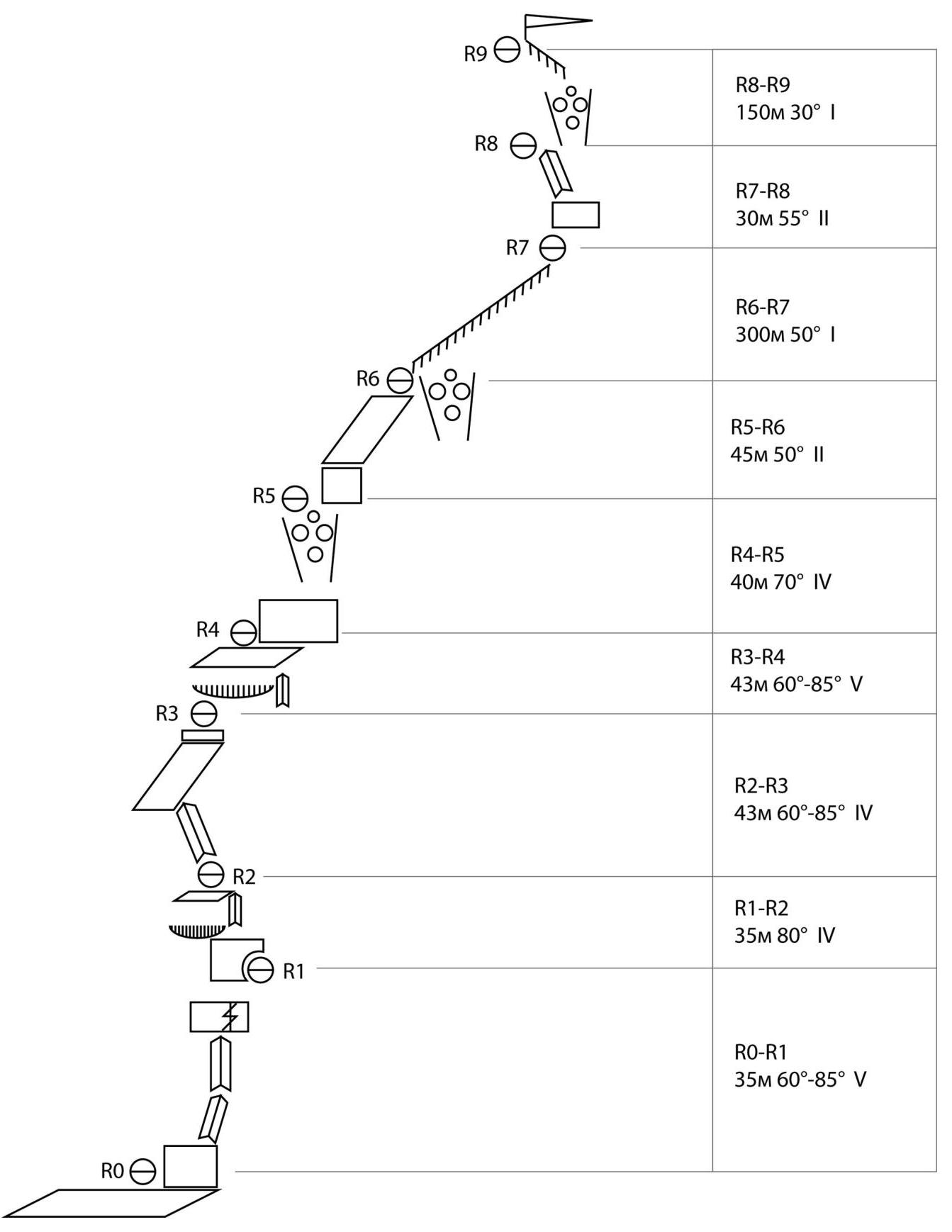
Description.
R0–R1
Start from a large ledge via the inner corner located in its right part. The first section (about 10 m) is quite steep, then the angle eases to 75°. After 15 m it leads to the base of a wide crack, overcome by free climbing. Immediately behind the crack there is a small ledge, with a bolt on the wall. Station made from the bolt and a protrusion.
R1–R2
Move vertically upwards from the station along the wall with a steepness of 80°. Movement occurs to the right of an overhanging cornice. After 35 m, move left, towards a ledge. Station on the ledge.
R2–R3
From the station, move left-upwards via a "lying" inner corner until exiting onto a ridge. Along the ridge (or along the slabs on the left), move upwards to a wall, above which a cornice overhangs. Under the overhang, on a slab, there is a convenient station.
R3–R4
From the station, move right for 5 m, then via an inner corner with a crack, overcome the cornice. Behind the cornice, there are several meters of easy climbing. Station on a large talus ledge.
R4–R5
Move to the right edge of the ledge and from there upwards along the wall (15 m) to rise into a talus gully. Station in the upper part of the gully on a protrusion.
R5–R6
Via the wall on the right, exit onto simple slabs (50 m), along which rise to a ledge. Station on a protrusion. This is the final rope of the wall.
Then descend onto a saddle between two gendarmes and via talus enter a steep rocky gully. Along the gully, rise upwards to the ridge. Further path is along the ridge to the beginning of route 1B. For a prepared team, it takes 25–30 minutes. The ridge leads to a large talus gully, along which one needs to rise to the start of route 1B cat. dif., and then follow it to the summit.
Descent via 1B and further to Pioner Pass.