Climbing Route Description
TO MT. PIONER VIA THE NORTHERN FACE.
1. General Geographical Information
Mt. Pioner is located in the Malo-Almatinsky spur of the Trans-Ili Alatau ridge, in the northern spurs of the Tian Shan mountains. The height of the described peak is 4100 meters above sea level.
The Malo-Almatinsky spur extends far to the north from the main ridge and is bordered by two gorges of the Malaya Almatinka and Leviy Talgar rivers. It ends with a small horseshoe-shaped formation of nine peaks, creating the Bogdanovich glacier cirque. The Bogdanovich glacier, 2 km long, gives rise to the Komosomolka stream, which flows into the Leviy Talgar river.
The snow line of the ridge is at 3400-3500 meters above sea level. The eastern, southern, and western slopes are free from glaciation. Pink granite is the primary rock forming the Pioner - Uchitel peaks massif.
The proximity of the desert and semi-desert zone significantly influences the harsh mountain climate, creating very favorable weather conditions for year-round climbing. The average annual temperature is +7...+10 °C. The minimum temperatures in January are -30...-35 °C. The prevailing wind direction is southwest.
2. Route Description to the Summit
There are two classified routes to the summit of Mt. Pioner:
- Category 1B difficulty - via the western couloir from Pioner sky pass;
- Category 3A difficulty - along the ridge when traversing the Pioner - Uchitel peaks.
Approaches
From Almaty city, take bus №6 to the Medeo settlement. Continue along the road to the Chimbulak ski base (2330 m) via the Medeo mudflow dam and past the Gorelnik tourist base.
From the ski base, the Talarsky pass is visible to the east-southeast, and the path to it lies along the cable car route. In winter, when the cable car is operational, its services can be used to save time.
From the Talarsky pass, the path goes strictly south. Initially along a trail past the remains of an old hut, and then along the terminal and left lateral moraines of the Bogdanovich glacier.
One can spend the night near the hut remains if desired. When reaching the Bogdanovich glacier, one should bypass a short ridge descending from the Shkolnik peak on the left and then, after overcoming the left bank moraine, reach the glacier. The wall of Mt. Pioner is visible in the upper reaches of the glacier. At this point, a panorama of six peaks is visible from the Bogdanovich glacier, in the order of their appearance in the sun: Chkalov, Fizkulturnik, the Uchitel-Pioner massif, Amangeldy, and Abai peaks.
The approaches end at the northwest corner of Mt. Pioner wall.
The path to the summit lies on the boundary between the northern and western walls along a not very pronounced buttress. The starting point of the route is marked by a snow "tie" and a rocky, ruined outcrop in its middle. The first few meters of ascent go through snow and then through ruined rocks of the buttress. Higher up, the rocks become more monolithic and challenging. Midway through the route, there's a large platform suitable for a good overnight stay. The route length is about 600 meters.
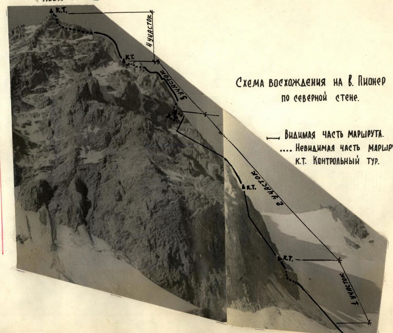
3. Detailed Description of the Sections
Section R1. Combined.
Ascent to the rocky outcrop via the snow "tie" - 15 m (snow, ice) with step cutting. The outcrop is small, 3-4 m wide. Then, again with step cutting in ice, move right onto ruined rocks.
Then, proceed under the wall to the right of the black rocks. The wall is bypassed by a traverse left-upwards for 30 m.
Attention! "Live" rocks, piton protection. Slope steepness is 65-70°.
Next, there's a good chimney 15-20 m high with a convenient platform at the top, where the first control cairn is built.
From here, all peaks of the Bogdanovich glacier cirque are visible.
In addition to the above-mentioned peaks, the beautiful Komosomol peak (4376 m), the highest point of the cirque, comes into view.
Section R2. Rock Climbing.
From the first control cairn, ascend upwards along a weakly expressed ridge (1st rope). The slope steepness is 60-65°. In the middle of the section, there's some verglas. The rocks are of medium difficulty. One piton is driven in the middle. Upon reaching under the monolithic wall of the buttress, two pitons are driven in for protection and self-protection.
Then, a 60-meter section is overcome along smoothed slabs, exiting at the end onto the main ridge. The buttress wall remains on the right. The slope steepness is 55-60°. There are few handholds; the section is challenging. Three pitons are driven in. Careful protection is required to reach the ridge.
A 40-meter ridge section follows with a steepness of 40-45°, of medium complexity. One piton is driven in. 2nd control cairn. After the 2nd control cairn, the ridge remains on the right, and along ruined rocks, after 50 m, there's an exit under a steep chimney. Piton protection - 2 pitons. At the base of the chimney, two pitons are driven in for protection and self-protection.
A 10-meter chimney leads to the ridge. The chimney has few handholds. Steepness is 75-80°. The section is challenging. One piton is driven into the rock. After the chimney, protection is organized through a ledge for the teammates.
Then, bypassing the monolithic ridge wall on the right along easy rocks, one reaches a very large, flat platform. The platform, about 100 m long, is convenient for an overnight stay. The third control cairn is located here.
From here, only the Amangeldy and Abai peaks are visible. The monolithic massif of black rocks - Mt. Pioner - comes into view.
The route continues along the ridge wall.
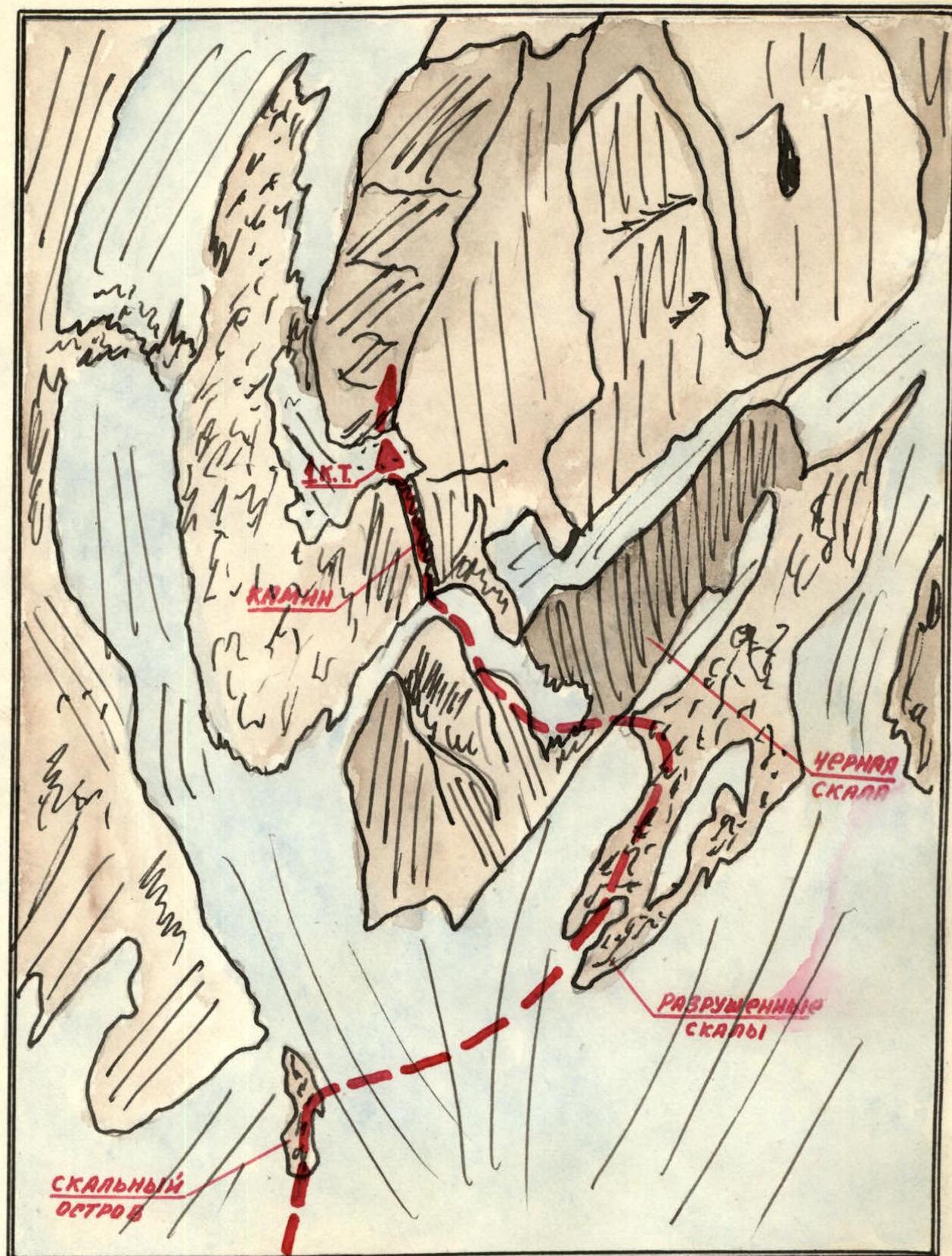
Section R3. Rock Climbing Route.
At the beginning of the platform, a connecting ridge is visible on the left (in the direction of travel), from which the ascent along monolithic rocks begins. A 40-meter segment is traversed with piton protection. Four pitons are driven in. This segment ends in a depression. Descent to the connecting ridge - 15 m. One piton, one sling.
Beyond the connecting ridge, there's a "gendarme" made of monolithic rocks. At the base of the "gendarme", a piton is driven in for protection. The "gendarme", 25-30 m high, is overcome directly to the middle, followed by a traverse to the right. Two pitons are driven in. The rocks are challenging. The "gendarme" walls are 70-80° steep.
Traversing the upper part of the "gendarme" leads to a narrow and sharp connecting ridge. Piton protection. 3 m higher along the ridge (after the connecting ridge), there's a place to stand for teammates.
After the connecting ridge, along the ridge (40 m), through несложным скалам – выход под стену «пальца». Движение попеременное. Страховка через выступы.
The "finger" is bypassed on the right along ledges, then a descent (15 m) into a depression onto a good, flat platform. Above the depression, there's a good ledge for organizing a descent. In the depression, the fourth control cairn is established.
From here, only the Komosomol and Amangeldy peaks are visible. The remainder of the route to Mt. Pioner is visible.
Section R4. Rock Climbing Route.
The entire section goes along the ridge. From the depression, a 15-meter ascent follows along несложным скалам. Движение одновременное. Then, a slight lowering leads to a sharp, rocky ridge.
Before the ridge, protection can be organized through ledges.
The ridge is 5 meters long, sharp, and is overcome "astride".
After the ridge, there's a pre-summit ascent of 35 m. The rocks are of medium difficulty, transitioning to easy on the last few meters. Protection is through ledges; one piton is driven in on the section.
The ascent is complete. A note is left on the summit in a cairn.
Descent from the summit is possible via two routes.
- Along route 1B category difficulty to the west towards Pioner pass.
- By traversing the ridge to Mt. Uchitel and descending from Mt. Uchitel to the south through a chimney along route 2A category difficulty. Both routes are classified.
Ascending Mt. Pioner via the northern wall and descending to Pioner pass takes 14-15 hours, assuming departure from and return to the hut remains on Talarsky pass.
Ascending Mt. Pioner via the northern wall, followed by traversing the entire massif, and descending south to the Manshuk Mametova glacier takes 19-20 hours (with an overnight stay under the wall).
For the route, the following climbing gear is required for a group of four: a) main rope - 2 × 40 m b) auxiliary cord - 6 m c) rock pitons - 15 pieces d) carabiners - 10 pieces e) rock hammers - 2 pieces.
The route is a wall-ridge route, not particularly hazardous. Comparing the ascent with some previously traversed routes, the group members believe that:
ascending Mt. Pioner with a descent along the path of category 1B difficulty corresponds to category 4A difficulty. Continuing the traverse of the entire massif increases the difficulty to category 4B.
The ascent to Mt. Pioner via the northern wall was made on March 17, 1970, by a group of climbers from the "Enbek" sports society.
Group composition:
- Kiselev L.M. - Master of Sports - participant
- Yuzhakov Yu.S. - Master of Sports - participant
- Sharafutdinov R.G. - 1st sports category - participant
- Mikhin V.A. - 1st sports category - leader
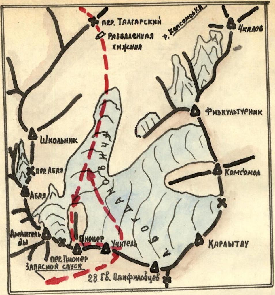
Peaks of the Bogdanovich glacier cirque and the group's route.
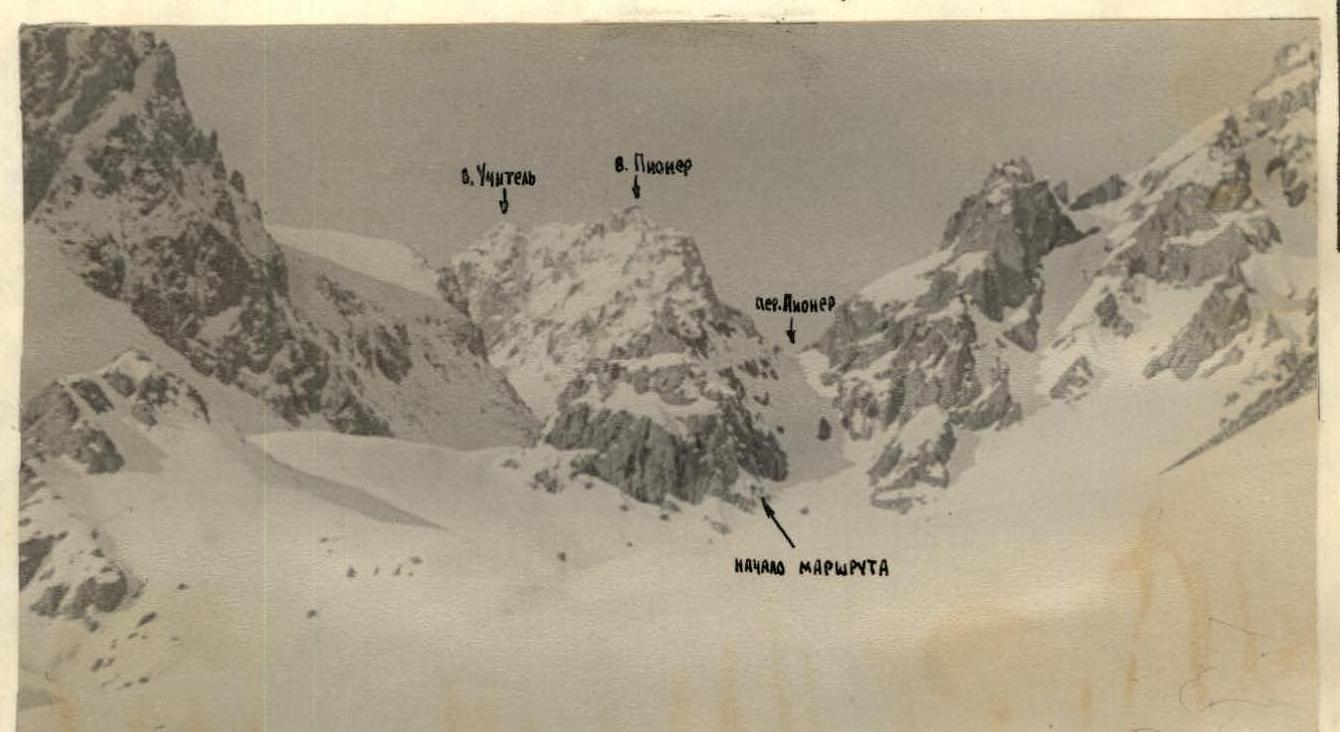
Pioner - Uchitel massif. View from the Bogdanovich glacier (from the East).
 ()
()
Section R1

Section R2
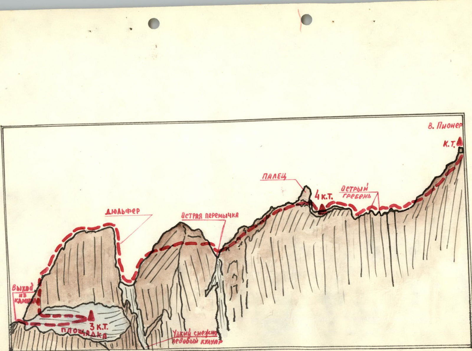
Sections R3 and R4.
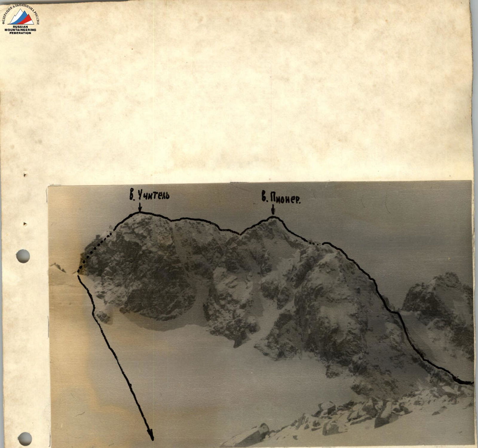
Traverse of Pioner - Uchitel peaks