SKA SAVO
Report
ON THE FIRST ASCENT OF THE SOUTH WALL OF PIK PIONER 4050 m (left side) VIA ROUTE CAT. III (approx.)
SKA SAVO Team
Golodov Yu.F. — Master of Sports — team leader, Chumakov V.D. — Candidate Master of Sports — team member, Pavlov V.F. — 1st class — team member, Nesolenyi V.P. — 2nd class — team member, Mozgovoi A.G. — 2nd class — team member. 190 cm, 40 m, 60°, 3 stoppers, 5 hours.
Almaty
June 22, 1980

Route profile on Pik Pioner 4050 m on the left side of the south wall Cat. III. Scale: 1 cm — 10 m.
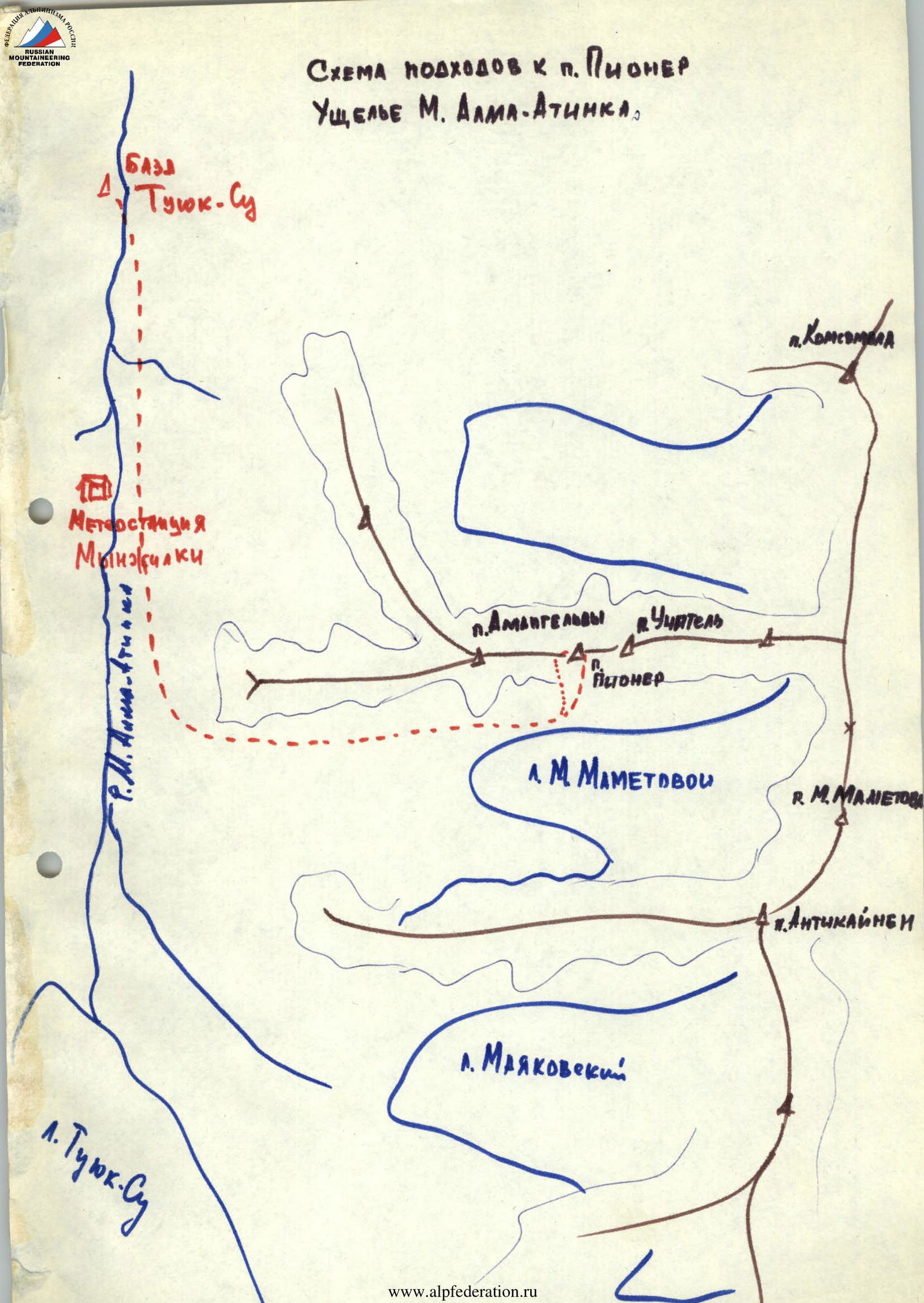
Description of the Approach to the Route
From Tuyuk-Su base (altitude 2600 m) follow the road to Mynzhilki weather station, then, after 500–600 meters, begin ascent to the right of the western spur rocks of Pik Amangeldy and ascend via ancient moraine to the cirque of Manshuk Mametova Glacier.
The trail initially leads to a fairly flat area — the dry lake bed, called "Alpinigrad" — a resting place, altitude — 3420 m.
From here:
- Reach the moraine ridge
- Follow the crest of the left moraine
- Approach the south wall of Pik Pioner
The start of the route is located on the left side of the wall at the base of a large and wide inner corner.
The journey to the south wall of Pik Pioner from Tuyuk-Su base takes 3–3.5 hours.
Approach scheme to Pik Pioner
Malaya Almatinka Valley.
Table
of main route characteristics on Pik Pioner via the left side of the south wall Cat. III.
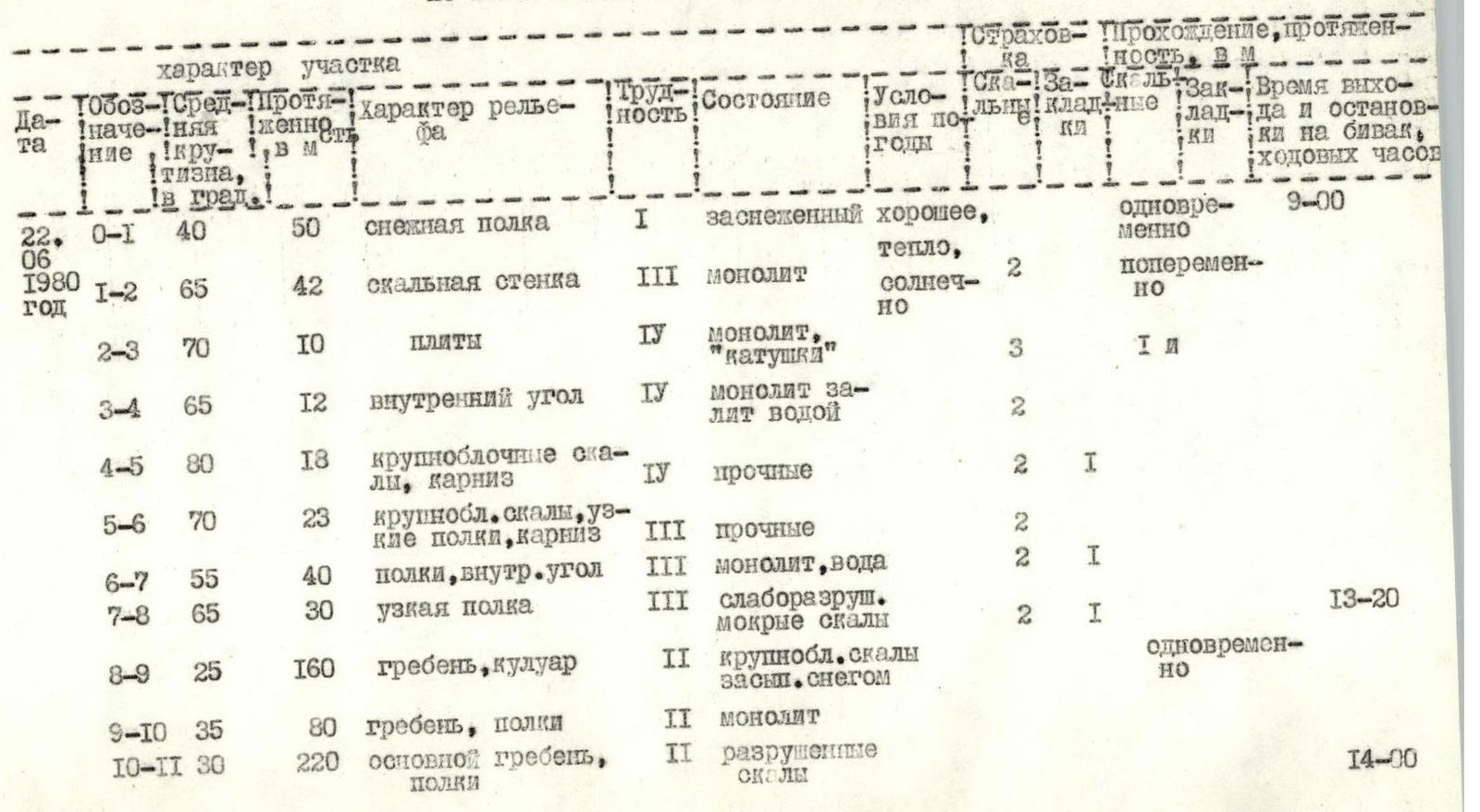
Explanation of the Table
Departed from "Tuyuk-Su" base at 6:30, arrived under the route at 8:40, started the route at 9:00.
Via a scree-covered snow shelf, reach a characteristic snow cone under the base of the inner corner. Ascend the left monolithic wall, 40 m, to a narrow shelf with a wide crevice above it. From here, traverse right across the inner corner (R3–R4) to reach under a small cornice on the right wall (R4–R5), then ascend directly up the narrow inner corner to a good shelf, with protection via a protrusion — "nose".
From the "nose":
- move a few steps left, ascend via large-block monolithic rocks (R5–R6) to good shelves (control cairn);
- continue directly upwards towards a white slab on the sheer face;
- from under which, again traversing the upper part of the inner corner, follow a narrow shelf (R7–R8) to the left onto the ridge.
Movement along the ridge — simultaneous 150 m, rocks weakly fractured. By-pass gendarmes on the left, traverse a small 4–5 m dip, reach a heavily fractured ridge, covered with snow, and move towards the summit 300 m.
Reached the summit at 14:00. Descent via Cat. I route to Pik Pioner Pass.
Brief Explanation of the Route
The route on Pik Pioner follows a wide inner corner on the left side of the south wall.
Due to the fact that the bottom of the inner corner is often wet (water seepage), it is more logical to traverse the sides of the inner corner, which is also related to safety considerations. The route was ascended wearing galoshes; climbing is quite challenging, with smoothed "ram's foreheads" on the R3–R4 section.
The extent of the wall section is about two hundred meters, requiring 10–12 rock pitons and stoppers; thin vertical pitons are used on the R1–R5 sections. A rope length of 40–42 m is recommended for convenient belay points.
The route is independent, logical, and not prone to rockfall; it is recommended for sports improvement groups.