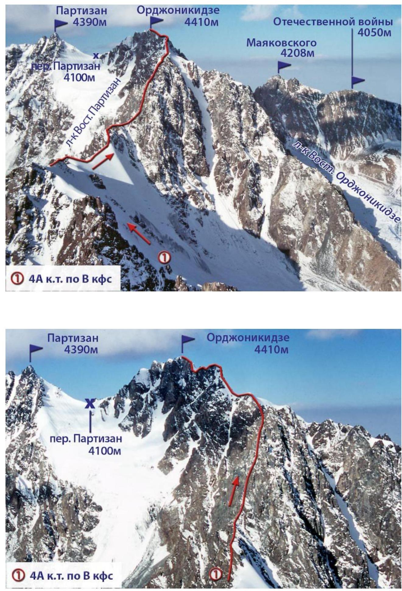
Ordzhonikidze 4A c.c. via the Eastern counterfort
Route description.
The approach to the start of the route is through the Ordzhonikidze Pass. Descend to the East Ordzhonikidze Glacier, bypass the northern wall of the summit, approach the northeast ridge, and move along it down the glacier. Having bypassed the ice fall of the northeast ridge, ascend the scree to its lowering, to the left of the rocky part. Descent from the ridge along the scree to the nameless glacier between the northeast and southeast ridges of the summit.
Descending along the glacier past the icefall of the "4089 m" peak, bypass two steep rocky spurs from the right and exit onto the northern counterfort of the southeast ridge of Ordzhonikidze. The exit to the characteristic lowering is via a wide, not clearly expressed couloir (be cautious of rockfall!). Move along the ridge part of the counterfort to the point of its junction with the southeast ridge.
First section:
- Overcome an inner corner of a wall, 50-60 m long.
- Behind it is a control cairn.
Further:
- Severely destroyed rocks of medium difficulty.
- Movement along the counterfort takes up to 2 hours.
Completion:
- Bypass the iglu at the junction of the ridges from the right.
- Here is the second control cairn.
The ascent continues along the southeast edge via severely crumbling rocks, overcoming a large number of gendarmes, which are mostly bypassed from the left.
In about an hour, there is an exit under a 40-meter wall. On its right side, there is a characteristic gap with a square gap in the upper part. The first 10 m are difficult climbing, with piton belay.
Behind the wall, the route becomes somewhat easier; there are ledges for belay.
Then again, there is a ridge part with a large number of small gendarmes. The rocks are crumbling, requiring maximum caution.
From the right side, the edge drops off with a sheer wall; on the left, rockfall couloirs descend. After 7 hours of movement along the edge, there is an exit to the "4089 m" summit. Here is a control cairn. The further path:
- Along the snowy ascents of the ridge,
- to the section of the so-called Saw. Under it, it is advisable to set up a bivouac for the night.
The second day begins with bypassing the Saw from the left along the rocks with thorough belaying. There is an exit along the ridge under a wall up to 200 m high. The first 50 m of the wall are overcome directly. Then, traverse to the right, under the white rocks with two deep cracks. Move below the cracks from the left and ascend onto the slabs, along which the approach to the upper tower of the wall is made. The tower is passed via a chimney with a plug; the rocks are difficult; further, along the sharp ridge of the gendarme, for 50-60 m, to a gap. From it, descend on a rope (30 m) onto a sloping shelf to the right. Having passed the shelf to the end, ascend the wall, 60 m, along very difficult rocks with piton belay (4-5 pitons).
From the wall, along easy slabs, exit to the top of the ridge (30 m), move along easy rocks. The next gendarme is overcome directly with a descent into a gap on a rope. A section of ice and difficult rocks (30 m) leads to the ridge. The next gendarme is overcome from the left side through the top. Behind it, there is an exit onto an ice bridge at the junction of the southeast and northeast ridges. The last segment of the route to the summit is along snowy-icy ascents up to 50° steepness. Here, the use of crampons and piton belay is required. The ascent, excluding approaches, takes up to 19 hours. Descent to the Ordzhonikidze Pass. The first passage of the route was made in August 1956 by a group of instructors from the "Kok Bastau" alpine camp under the leadership of Yu. Mimin.
Recommendations:
- Number of participants: 4-6 people.
- Initial bivouac at the Ordzhonikidze Pass.
- Exit from the bivouac at 5-6 am.
- Equipment for a group of 4 people:
- Main rope — 2×30 m
- Expendable reepschnur — 15 m
- Rock pitons — 8 pcs
- Ice axes — 4-5 pcs
- Hammers — 2 pcs
 (1)
4A c.c. via E counterfort
(1)
4A c.c. via E counterfort
Ordzhonikidze 4410 m
Of the Fatherland War 4050 m
Partizan Pass 4100 m
Ordzhonikidze 4410 m
Partizan Pass 4100 m
(1) 4A c.c. via E counterfort
Author: Zhunusov B.
Source: Book "Alpinist Routes. Trans-Ili Alatau". Part 1 from the site Mountain.kz