North Tien Shan, Trans-Ili Alatau
Peak Oktyabrionok via the bastion of the North Face
4A cat. diff.
Climbing Passport
- Region, gorge, section number according to the classification table of 20__ year — North Tien Shan, Trans-Ili Alatau, Maloye Almatinskoye gorge.
- Name of the peak, its height, name of the route: Peak Oktyabrionok 3650 m, via the counterfort of the North Face.
- Proposed: 4A cat. diff.
- Nature of the route: rock
- Height difference of the route: 330 m
Length of the route: 400 m. Length of sections: V cat. diff. — 10 m. Average steepness: main part of the route — 70°; entire route — 55°
- Number of "hooks" left on the route: 5, including drill anchors — 0.
- Team's walking hours: 6 hours
- Leader: Kirill Belotserkovsky, 1st sports category
Participants: Dmitry Degtyarev, 2nd sports category
- Coach: Alexey Raspopov
- Exit to the route from Base Camp: September 20, 2007
Route started: 9:00. Summit reached: 15:00. Return to Base Camp: 17:00. Descent from the summit: via the route 1B cat. diff. to the Oktyabrionok pass
-
Organization: a/c Khan-Tengri
-
Responsible for the report — K. Belotserkovsky
Email and phone: k.belotserkovskiy@gmail.com, +7 701 736 18 87
Map-scheme
of the area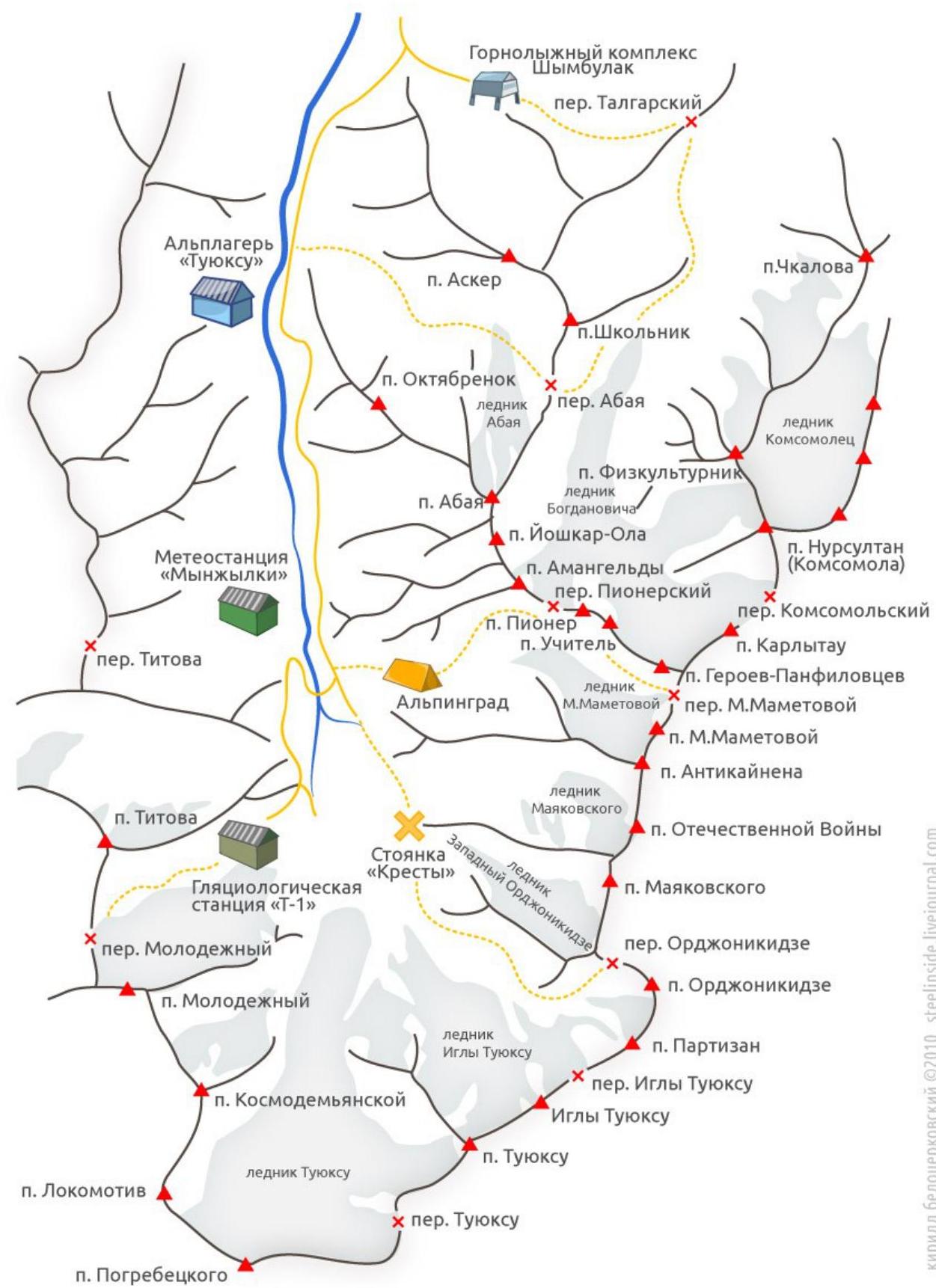
General photo
of the wall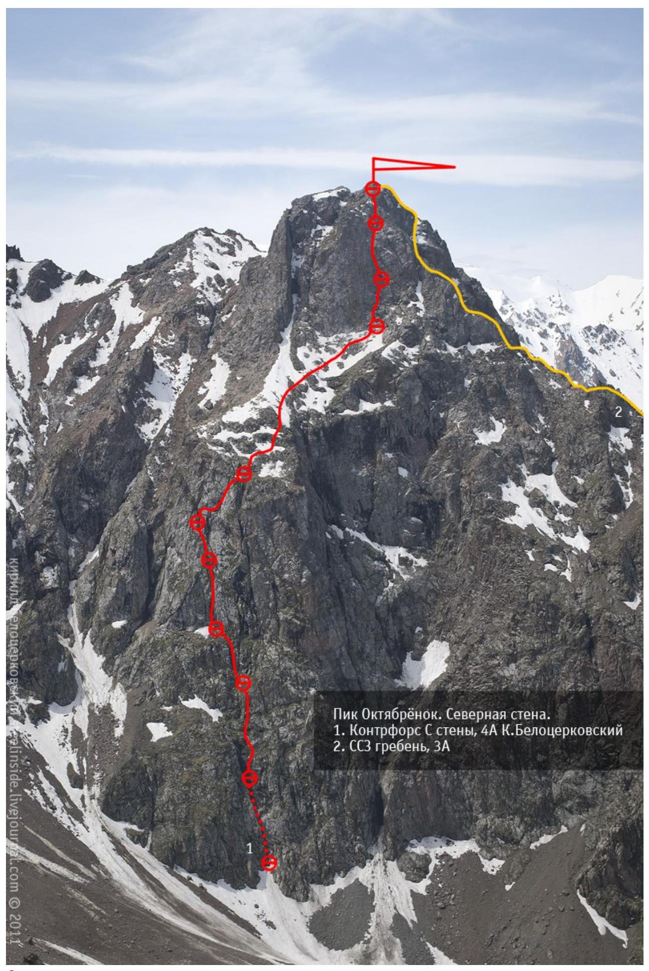
Scheme of the route Peak Oktyabrionok Central counterfort of the North wall,
4A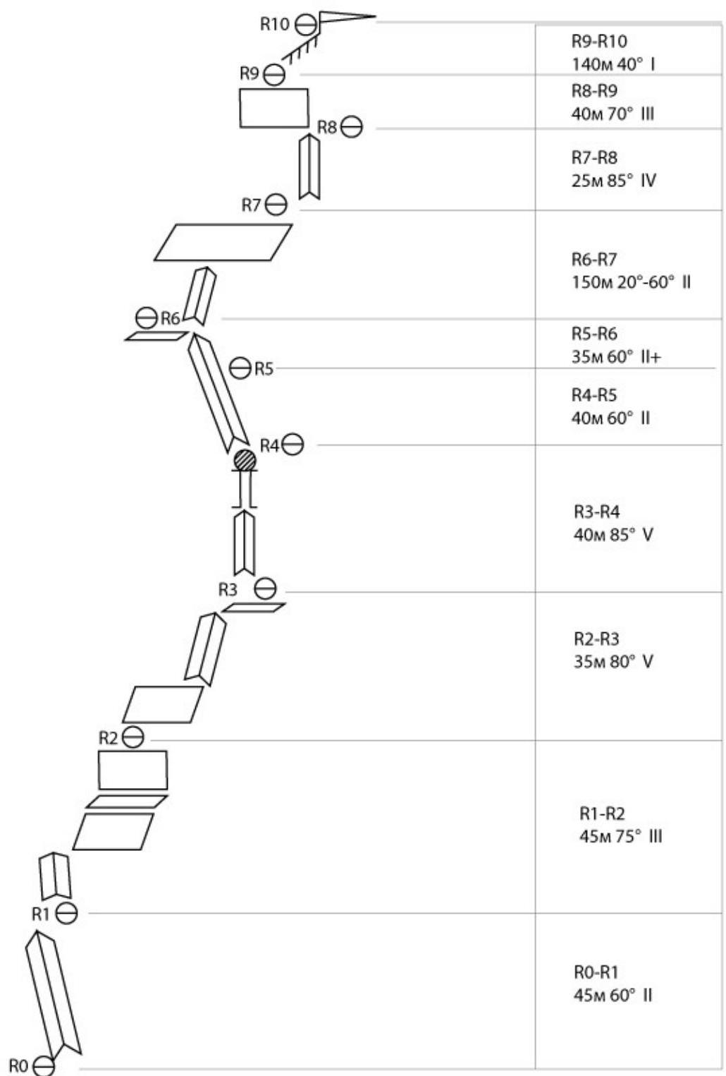
Description.
R0–R1
The movement starts along the internal angle — a chimney, cutting the counterfort in two in the lower part. It is necessary to move along the angle very carefully so as not to knock down loosely lying stones on your companion.
R1–R2
The angle opens up, and it makes sense to:
- move right onto the wall,
- which leads to a grassy ledge.
R2–R3
Move up and left along the walls — ledges. Station on a ledge on a protrusion.
R3–R4
The key to the route. From the station, two possible paths are visible:
- right onto a wall with a steepness of about 70°;
- left, into the internal angle with black streaks.
The angle is significantly steeper, but it is possible to organize protection there, which is much more difficult to do on the wall to the right. So, up the angle. The angle gradually turns into a chimney. There is a plug in the chimney, which is passed directly upwards. Difficult.
R4–R5
The next rope is also along the angle.
R5–R6
Further, in a team, traverse left and upwards along steep grassy ledges to a small ledge with a juniper bush.
R6–R7
From the station, move right and upwards along the internal angle, leading to a large ledge. Along the ledge, in the direction of the chimneys. The chimney on the left is excessively wide and steep, while the one on the right is quite passable.
R7–R8
Begins with 20 m of internal angle, then a large stone is bypassed on the left, then right and upwards along a couloir with grass to a protrusion, where the rope is anchored.
R8–R10
Further, in a team, move along the ledges to the summit.
Descent to the pass and further along the couloir to the road leading to Mynzhylki.