Northern Tien Shan, Zailiyskiy Alatau
Peak Oktyabrionok
via the central bastion of the NW edge
4A cat. diff.
Ascent Passport
- Region, gorge, section number according to the classification table of 20__ year — Northern Tien Shan, Zailiyskiy Alatau, Maloe Almatinskoe gorge.
- Name of the peak, its height, name of the route: Peak Oktyabrionok 3650 m, via the right part of the Western edge
- Proposed: 4A cat. diff.
- Nature of the route: rock
- Height difference of the route: 540 m
Length of the route: 600 m. Length of sections: V cat. diff. — 15 m. Average steepness:
- main part of the route — 70°
- entire route — 55°
- Pitons left on the route:
route is equipped with stationary pitons (bolts)
- Team's walking hours: 6 h
- Leader: Denis Urubko
Participants: Artyom Skopin
- Coach: Ilyinsky E.T.
- Exit to the route from the Base Camp: -// — // —
Route started: -// — // — Exit to the summit: -// — // — Return to the Base Camp: -// — // — Descent from the summit: via route 1B cat. complexity to Oktyabrionok pass
-
Organization: CSKA MO RK
-
Responsible for the report: K. Belotserkovsky
Email and phone: k.belotserkovskiy@gmail.com, +7 701 736 18 87
Map-scheme
of the area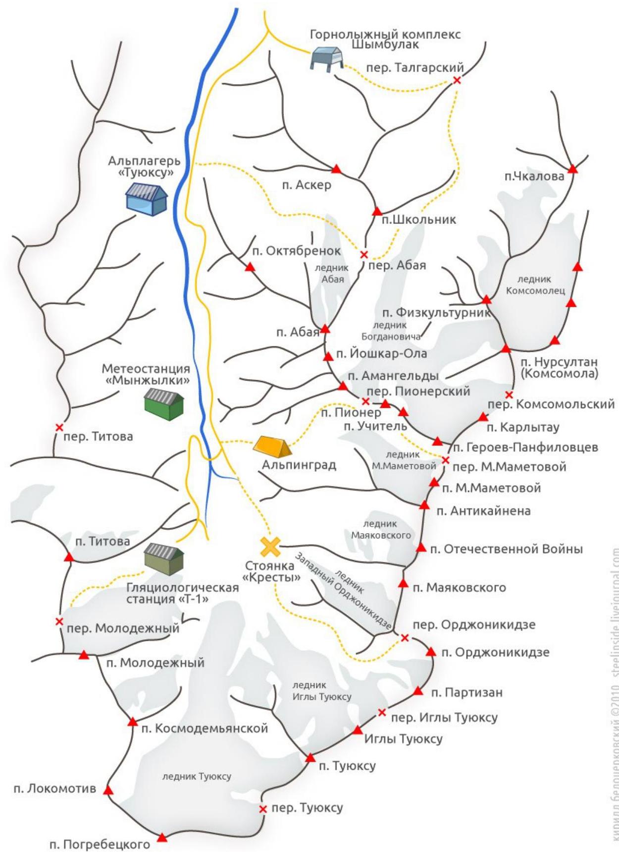
General
photo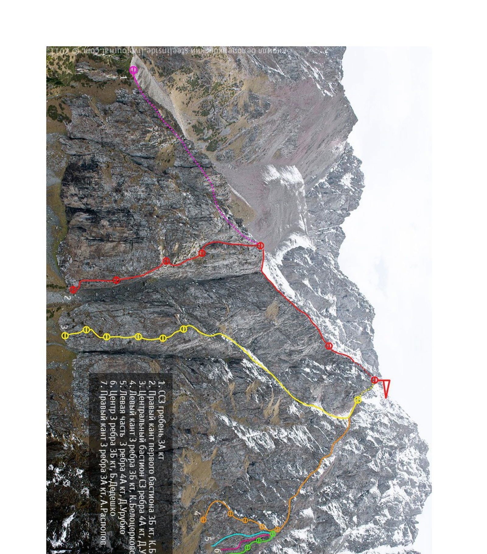
-
SOZ ridge Zakt.
-
Right edge of the first bastion 3B cat. diff. K. Belotserkovsky
-
Central bastion of the NW edge 4A cat. diff. D. Urubko
-
Left edge of the 3rd edge 3B cat. diff. K. Belotserkovsky
-
Left part of the 3rd edge 4A cat. diff. D. Urubko
-
Center of the 3rd edge 3B cat. diff. B. Der viko
-
Right edge of the 3rd edge 4A cat. diff. A. Ruslonia
Route scheme
Peak Oktyabrionok via the Central Bastion 4A cat.
diff.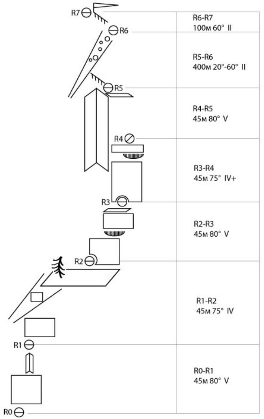
Description.
R0–R1
The route starts at the lowest part of the Central Bastion. Move right — up, cross the inner corner, and go a little to the right. Then overcome a gentle overhang, and move higher. The route is "pre-drilled", so there's no need to tie up to cracks, etc.
R1–R2
From the station, move a couple of meters to the right, then vertically up, to the exit to the grassy couloir. Up the couloir to a large grassy ledge, at the top of which is the station.
R2–R3
From the station, move up the system of inner corners. After 20 m, go to the right onto the slabs. Climb to a small ledge, which can be passed:
- "head-on" (more difficult),
- or you can go a little to the left, it gets a bit easier.
This is the first key of the route (fr 6a/+).
R3–R4
From the station, move vertically up. The last 10 m of the section have a steepness of up to 90°, but there are hand and footholds. At the station, long self-belay ropes are needed, otherwise it will be hanging.
R4–R5
To the left upwards onto the right wall of the large inner corner, climb 10 m and go slightly to the right onto the contforce. Then:
- Vertically up, following the logic of the relief.
Station is 15 m below the saddle between the contforce of the Bastion and the ridge.
R5–R6
Climb up the corner to the saddle, from which move to the right — up to the exit to the top of the bastion. From there, move in the direction of the summit. Moving along the ridge is illogical, so it's better to descend into the couloir, located on the left (in the direction of movement), and move up it. In the upper part, you need to transfer to the adjacent couloir, which passes on the right, and exit to the pass. From the pass, climb to the summit tower, bypassing it from the north side.
Descent to the pass and further down the couloir to the road, leading to Mynzhylki.