Ascent via the North Edge from the Molodaya Gvardiya Glacier — cat. diff. 2B (4394 m) (fig. 10)
In the southern part of the Malo-Almatinsky spur, which is the watershed of the Bolshaya Almatinka and Levy Talgar rivers, rises the majestic ice-snow pyramid of the Molodaya Gvardiya peak.
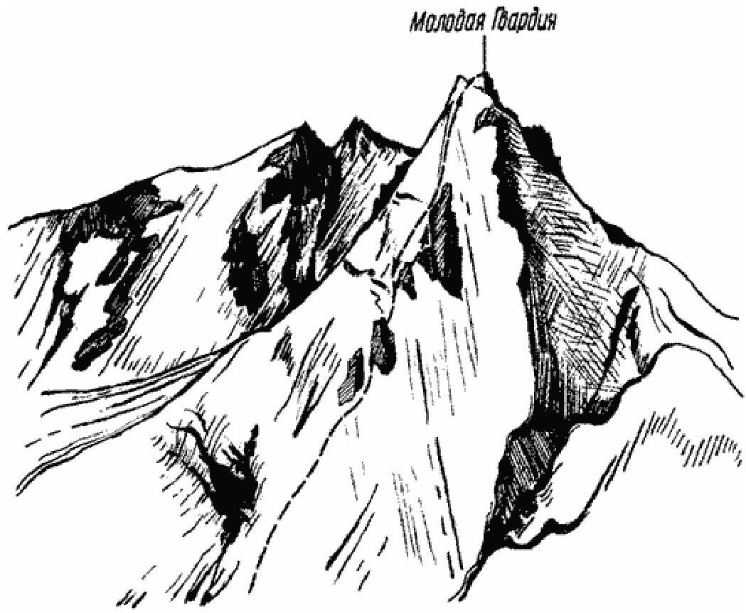
Fig. 10 The most convenient approach paths to the route are via the Ozerny valley to the Gryazny Glacier. The initial bivouac is organized on the moraine of the glacier. Moving along the right side of the glacier and overcoming a series of crevasses, one exits onto a relatively gentle section at the foot of the northern slope. Continue the ascent up the ice slope with a steepness of up to 40° to the first sentinel on the northern edge of the peak massif. Cats are required on this section. Having overcome the bergschrund and a small icefall, approach the heavily destroyed rocks. Then proceed along the edge; the rocks are of medium difficulty, and exit onto the main North Edge, which approaches the first sentinel. There are cornices on the eastern side of the ridge (be cautious!). The sentinel, up to 20 m high, is bypassed on the right via cut steps in an ice gully, with a steepness of up to 50° and a length of 20–25 m. After ascending onto a very sharp ridge, within 15 minutes one can approach the second sentinel, which is up to 50 m high. After a terrace, there is an exit onto a small steep scree leading to rocks of medium difficulty and onto a steep snowfield ending in a small cornice. To exit onto the ridge via the cornice, a diagonal cutting is necessary. The approach to the third sentinel, located up to 500 m from the second, is via a gentle (25–30°) ice slope. Bypassing this sentinel is most challenging only from the eastern side, above a wide crevasse that stretches along the eastern slope of the peak. The ascent section is mostly covered in regelation ice for a significant part of the season, overcome with cats and thorough piton protection, its length is up to 60 m. Further, after a small plateau, the slope becomes gentler and leads onto the ridge, the northern edge of which is snow-ice, requiring step cutting in places. Before the peak, a bergschrund 8–9 m wide is overcome. The peak itself is a triangular snow plateau, bordered by rocks on the southern and western sides. A cairn is built on its southern part. Descent is via the ascent route. The ascent takes 12–14 hours. The first ascent via this route was made in October 1943 by a group of instructors from the mountain training school, consisting of: Yu. Gudkov, B. Shnayder, led by V. Nearonsky.
Recommendations for Climbers
- Number of participants: 4–6 people.
- Initial bivouac on the moraine of the Gryazny Glacier.
- Departure from the bivouac at 4:00.
- Equipment for a group of 4 people: a) main rope — 2x30 m; b) rock pitons — 5–6; c) ice pitons — 7–8; d) hammers — 2.