Location, Approach Route, and Ascent History
The peak named after the youth newspaper "Leninskaya Smena" is located in the central ridge of the Trans-Ili Alatau. Its western ridge descends to the well-known Ozerny pass, through which a tourist path leads to the shores of Lake Issyk-Kul (see the map of the Leninskaya Smena peak area).
From Almaty Lake, the approach to the peak is made along a well-trodden path up the gorge, along the Ozerny River, which flows into the lake. The time it takes to approach from the lake to the confluence of the South-Eastern River and Ozerny River is about 4 hours.
Further, the path goes to Ozerny pass along both the right and left banks of the Ozerny River:
- The approach to the peak is more convenient along the right (orographic) bank.
- The descent is along the left (orographic) bank.
From the confluence of the rivers to the tongue of the glacier, flowing west from the northern ridge of the Leninskaya Smena peak, it takes another 1.5–2 hours.
The most acceptable and convenient path to the summit is the ridge that branches off from the northern ridge and merges with it not far from the summit (see the map). It was along this ridge that the first ascenders took the path in 1956 (a group of climbers from the Kazakh club led by Kucherenko G.).
A group of climbers from the Institute of Nuclear Physics of the Kazakh SSR Academy of Sciences, led by Saprykin V.D., climbed the same route on September 2, 1956, and this description was compiled based on that ascent.
In September 1965, a group of employees from the editorial office of "Leninskaya Smena" led by V.K. Makhanov made an ascent to the peak from Ozerny pass.
Description of the Ascent Route to Leninskaya Smena Peak via the Northern Ridge, Category 2A
Having approached the tongue of the glacier flowing west from the northern ridge of Leninskaya Smena peak, the group tied up at 8:00 and began moving along the closed glacier towards the saddle on the ridge (see photo No. 1). The cross marks the place of exit to the ridge. It is also possible to reach this place from the opposite side - along the glacier and then along the small scree.
The further path to the summit is shown in photo No. 1:
- First, exit to the northern ridge of the summit;
- then along it to the summit itself.
On the marked path, there are individual steep snow-ice sections. Therefore, depending on the snow conditions of a particular year, there may be larger or smaller ice sections both when exiting to the northern ridge and when exiting to the summit itself.
In this regard, the group should take:
- several ice screws (2–4 pcs.);
- a pair or two of crampons.
The entire route is mainly snow-ice in nature. The northern ridge abounds with sharp snow ridges and cornices (see photo No. 2, taken from point "ф" on the northern ridge in photo No. 1). Therefore, it is necessary to choose the right path along the ridge and apply appropriate insurance.
From the glacier tongue to point "ф" on the northern ridge, the group (13 people) spent 3 hours in favorable snow conditions and excellent weather.
From point "ф" to the summit:
- the path is well shown in photo No. 2;
- it takes about 1.5–2 hours.
At 12:30, the group reached the summit.
Due to the very favorable snow cover on the route, the descent was made along the ascent route in 1.5 hours.
Under other snow conditions, it is recommended to descend from the summit to the south along the scree of Ozerny pass, which will take about 30 minutes.
However, this will require:
- climbing to Ozerny pass from the right;
- crossing it;
- descending to the Ozerny River along the tourist trail.
This descent path is simple but longer.
At 17:00, the group descended to Almaty Lake, from where they arrived in Almaty by car.
The described route is snow-ice in nature and can be assessed as a Category 2A route.
Description compiled by
V. Saprykin
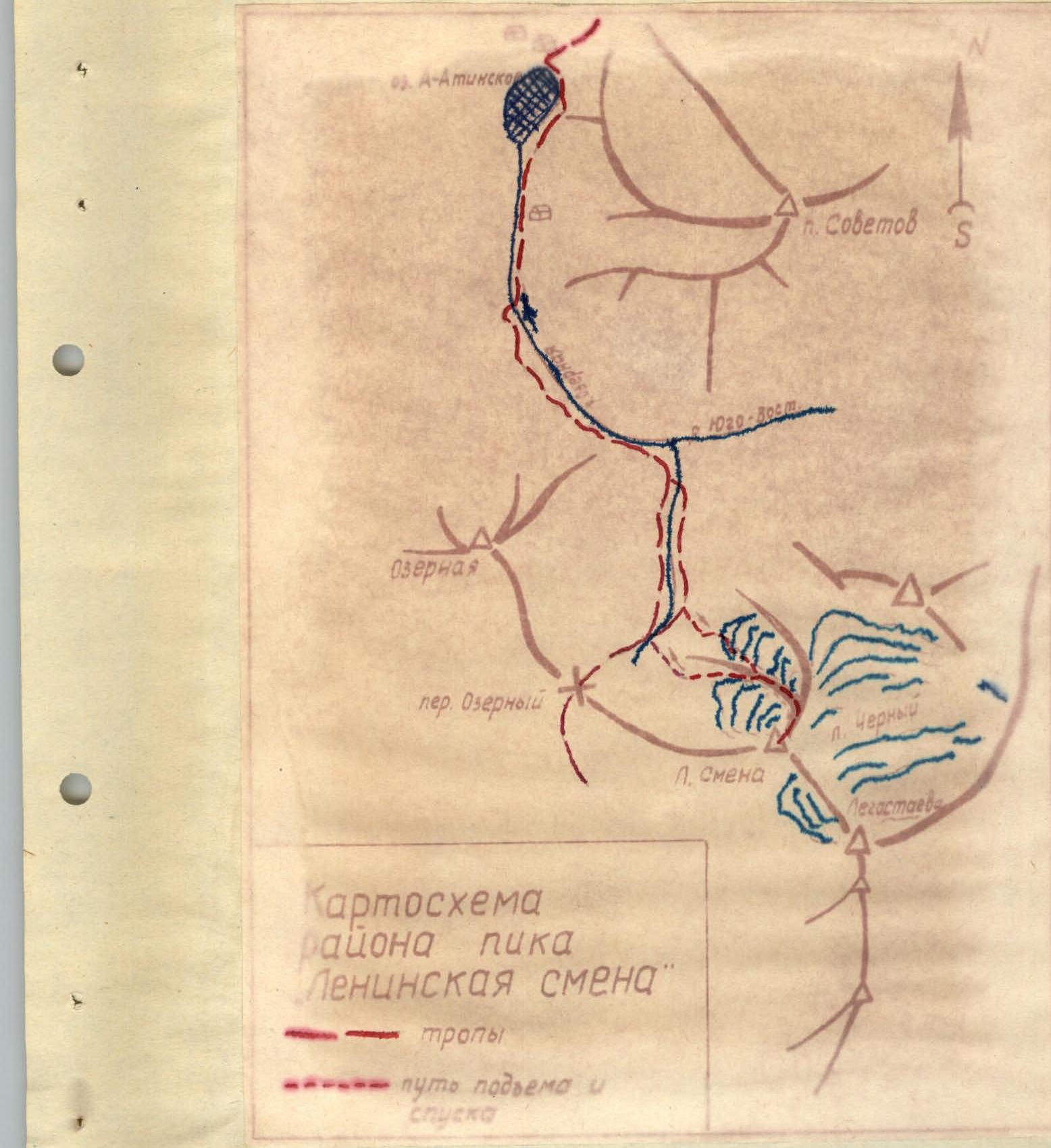
Photo No. 1. The ascent route from the glacier tongue with exit to the ridge and further along the ridge to the summit.
- the place of exit to the ridge; point "ф" - the place where photo No. 2 was taken.

