82
Orography of the Upper Reaches of the Uzun-Kargaly River Basin
(Jasil-kul Glacier)
The Jasil-kul glacier is located in the western part of the Zailiyskiy Alatau ridge, in the upper reaches of the Uzun-Kargaly river. Its length is about two kilometers, and it is oriented from north to south. At the glacier tongue:
- a long lake stretches across the moraine,
- the glacier tongue descends steeply towards the lake.
In the depths of the cirque, the "Uzlovaya" peak rises, from which the Tasso-Kemin ridge extends southwest. In 1940-1941, alpinists from Kyrgyzstan first visited this area and summited several peaks:
- Tumannaya
- Aszhaluu
- Druzhby
- and others.
This area is now well explored by alpinists.
In 1956, the Mayashev-Kuderin group visited the upper reaches of the neighboring Maybulak river and successfully summited several peaks.
The average height of the main ridge in this mountainous area is 4000-4100 m. The lateral ridges have almost the same height, and some peaks are even higher than the main ridge.
The described peaks are located in two lateral ridges, between which the Jasil-kul glacier lies.
The peak "Kompartii Kazakhstana" is the northernmost peak of the ridge separating the Jasil-kul glacier from the Maybulak glacier. It is connected to the main ridge in the area of the peak Tәke-Tau. The peak "Kompartii Kazakhstana" has two distinct peaks: the northern (3950 m) and southern (4200 m) peaks, separated by a deep saddle, conditionally named "Pereval 11-ti" (Pass of 11).
The southern peak is a double-horned tower with very steep rocky
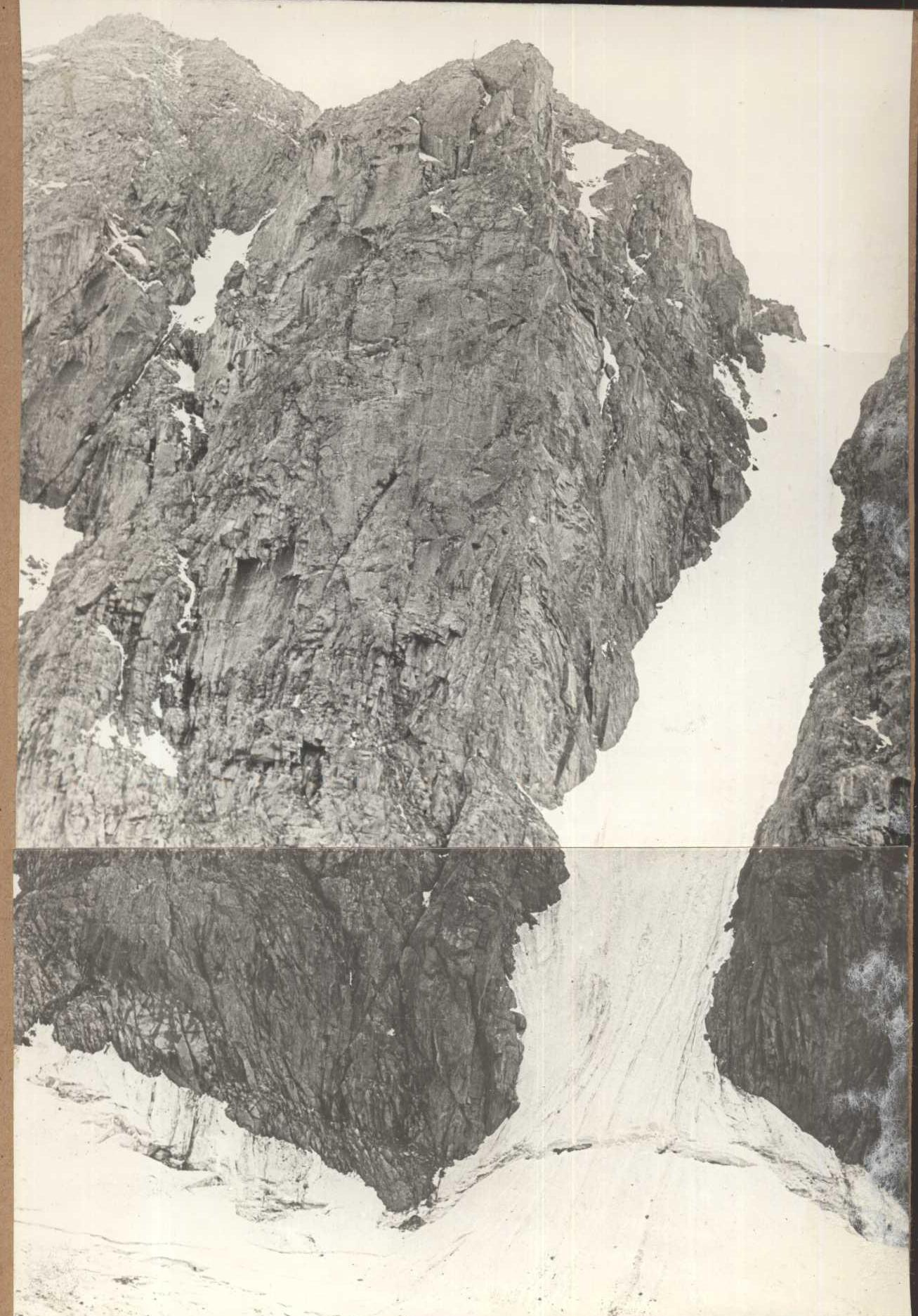
 walls. The northern peak is a massive rocky tower with a small hanging glacier on its northern slope, which is flanked by sharply dissected ridges on both sides. The section of the ridge from the peak "Kompartii Kazakhstana" to the main ridge is a series of peaks similar to the described ones, broken by deep saddles. The traverse of the entire ridge is undoubtedly a serious mountaineering challenge.
The eastern lateral ridge has a weaker dissection, but it also features very interesting peaks.
The northernmost peak of this ridge has a height of 4050 m. It has steep ridges to the west and east, and a snowy slope to the north. This peak is named in honor of the 40th anniversary of the Kazakh SSR.
Description of the Traverse of the Northern and Southern Peaks of "Kompartii Kazakhstana"
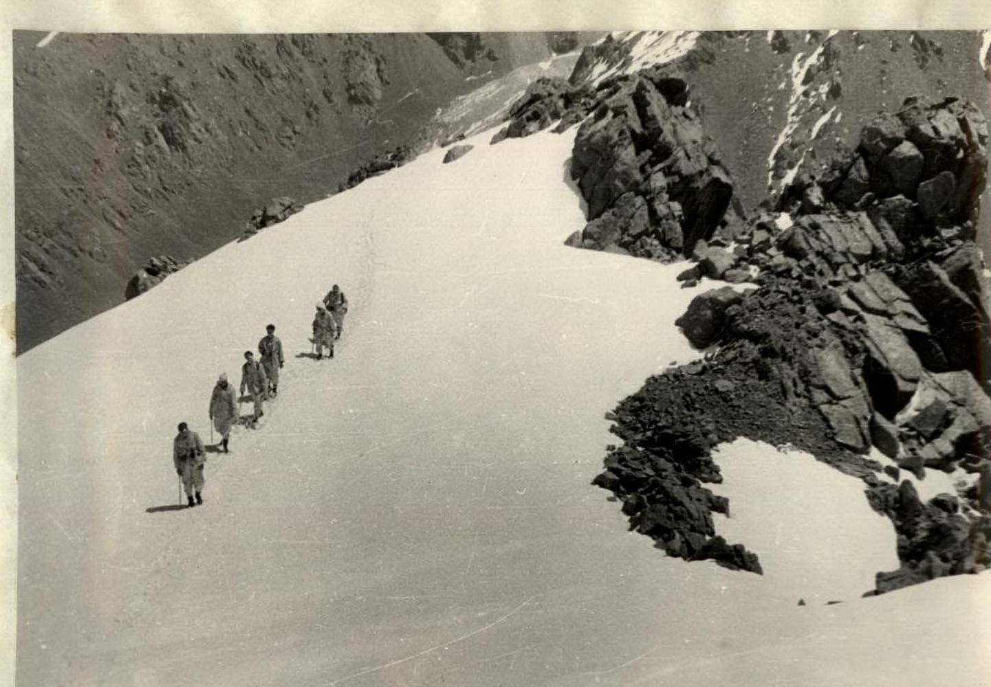
From the base camp, located on the ancient lateral moraine of the Jasil-Kul glacier at an altitude of 2800 m, we set out for the ascent at 5:00. The path goes along the left (orographic) ancient lateral moraine, then descends diagonally into the Jasil-Kul riverbed and begins to ascend along a steep grassy and talus counterfort to the beginning of the northeast ridge leading to the shoulder of the peak.
The lower part of the ridge is:
- rocky,
- the middle part is combined,
- the ascent to the shoulder of the peak is a snow slope (into which the northeast ridge merges).
The height of the base of the ridge is 3060 m.
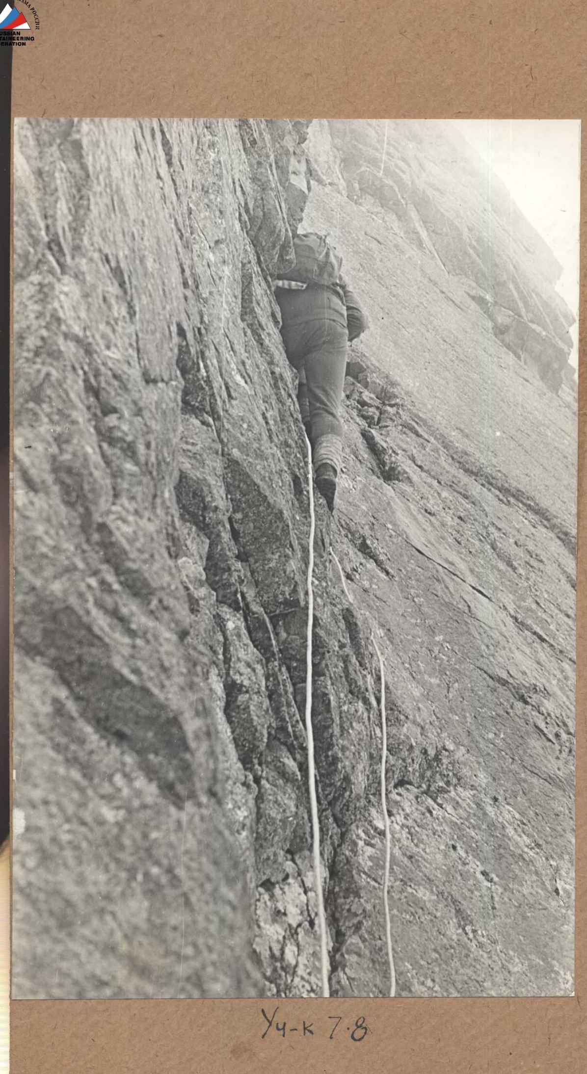
Initially, the path is straightforward: talus and easy rocks. This section, 120-150 m long, is traversed without being tied up until the base of R1 "gendarme". After tying up, we begin to move through the "gendarme" obstacles, which become increasingly complex as the slope steepens.
The first two "gendarme" are climbed "head-on" through easy rocks. R3 and R4 are traversed from the right along ledges on medium rocks with protection through outcrops. R5 is overcome "head-on" through medium rocks, where two pitons have to be hammered.
By bypassing R6 and R7 "gendarme" from the left along medium rocks, we reach the base of R8 "gendarme", which can be called a "tooth". Steep walls, a narrow tower, and a height of about 120 m distinguish it from the others. The path to the base of the "tooth" takes 4 hours of work on easy and medium rocks.
Initially, we move towards the "tooth" through medium, and then difficult rocks with careful piton protection, then exit to the right (along the route) onto a snow slope. Here, we move with protection from pitons hammered into the wall of the "tooth" on the left. Steps are cut into the ice, and rocky slopes on the left are used to the maximum.
This section required the use of eight pitons and the cutting of more than 50 steps. Its length is about 130-140 m. Before exiting onto the ridge behind the "tooth", 40-meter-long ropes were fixed. A control cairn was built on the ridge behind the "tooth".
The further path goes along a snowy ridge, which abuts a wall of the peak's shoulder. The lower part of the wall consists of medium and difficult rocks resembling "ram's foreheads" with few footholds and ledges. Protection is only through pitons. Six pitons were hammered along the length of two 40-meter ropes. From the "ram's foreheads", an icy slope with a steepness of 55-60° ascends. Here, movement was organized using ice screws. With intermediate protection, the leader would move forward on crampons for 40 m and secure the rope as a fixed rope. The partner would then approach and move up another 40 m, hammering ice screws along the way. The rest of the group would ascend using the rigidly fixed ropes without crampons, taking advantage of a 3-4 cm layer of frozen snow lying on the ice.
Then, a snowy slope begins again, leading to the shoulder of the peak after 60-70 m. Protection on this slope is achieved through ice axes. Turning sharply to the right, the path leads along a sharp ridge towards the peak. The length of the ridge is 350-400 m. To the right is a steep icy slope, and to the left are vertical walls descending into a couloir. Protection is achieved through ridge features and outcrops. The summit tower on the side of the shoulder is snowy, 150-200 m high, with slope steepness of 40-45°. The height of the peak is 3960 m (according to the altimeter).
The journey from the base camp to the peak took 12 hours of intense work. All 11 participants of the expedition reached the summit.
The descent from the peak is directed south towards the saddle between the northern and southern peaks of the "Kompartii Kazakhstana", conditionally named "Pereval 11-ti" (Pass of 11).
The descent involves a 20-25 m vertical wall traversed by sitting on a rope. Then, medium rocks transition into talus. The length of the descent is 200-250 m, and the time taken is 1 hour. From the saddle, a group of climbers began their descent towards the Jasil-kul glacier via a snowy couloir with a steepness of 40-45°. The group consisting of Usenov and Kolodin remained at the pass to continue their route to the peak "Kompartii Kazakhstana".
At 20:00, the climbers successfully traversed the couloir and signaled "All is well".
On May 31, 1953, at 6:00, Usenov and Kolodin set out on their further route.
Immediately from the saddle, a sharp ridge ascends. After climbing a wall, we reach a horizontal 35-meter section of the ridge, which is extremely narrow. We overcome this section using the "konkovy" method. This section leads us to a sharp ascent of the ridge. The steepness of the ascent is 75-80° — completely smooth rocks without cracks. Therefore, we have to traverse the wall to the right. After ascending the ridge by 2 m, we hammer a snow piton and exit onto a smooth wall. There are so few footholds and ledges that six pitons have to be hammered along the 30-meter path. The spot for protection after 30 m is good: a rocky finger that has separated half a meter from the wall. Further, there is a descent onto a narrow ledge — 3.4 m below the finger.
We move along the ledge, gradually ascending to the left. At 35 m, four pitons are used.
Here, we reach the beginning of a rocky chute with a plug in the middle. We ascend the chute for 40 m to a small rocky shoulder. The difficulty of the chute lies in the plug, which is filled with ice. We have to chip it away with a hammer. Five pitons were used for these 40 m.
Then, along a wide terrace cluttered with rocky boulders that fall down at the slightest touch, we move to the right for 30 m to the base of an icy chute leading to the main ridge. Its length is 70 m.
We decide to move along the rocks on the right and left and along embedded stones, using both rocky and icy pitons for protection. Overcoming the chute required:
- 2 hours of work
- seven rocky pitons
- two ice screws
The sharp ridge abuts a summit tower 100 m high. The rocks are difficult, with a "tiled" structure, requiring constant piton placement.
After ascending 50 m, we traverse the tower to the right, onto a shoulder.
From the shoulder, a 10-meter chimney leads to the east onto the tower, and above it is an inclined slab with rocks.
After hammering two pitons, we traverse the chimney and ascend along inclined slabs towards the peak.
Kolodin and Usenov reached the summit at 14:00.
The peak is double-horned. The second tower, equal in height to the first, lies at a distance of 25-30 m.
We build a cairn on the first tower and begin preparing for the descent.
The ascent to the peak for the two masters took 8 hours of work. For the descent, we extensively used a rope. We rappelled from the tower and traversed the icy chute. The descent to the saddle took 4 hours. Further, we descended along a snowy couloir following the path of the climbers. The total traverse of the peaks took about 30 hours of complex rocky and icy work.
Based on the above, the group believes that the northern peak should be classified as 2B, and the traverse of the Northern and Southern peaks of "Kompartii Kazakhstana" as 4A category of difficulty.
 (U. Usenov) (V. Kolodin)

A small plateau at an altitude of 3900 m on the peak "Kompartii Kazakhstana".

The northern tower (3950 m) of the peak "Kompartii Kazakhstana".
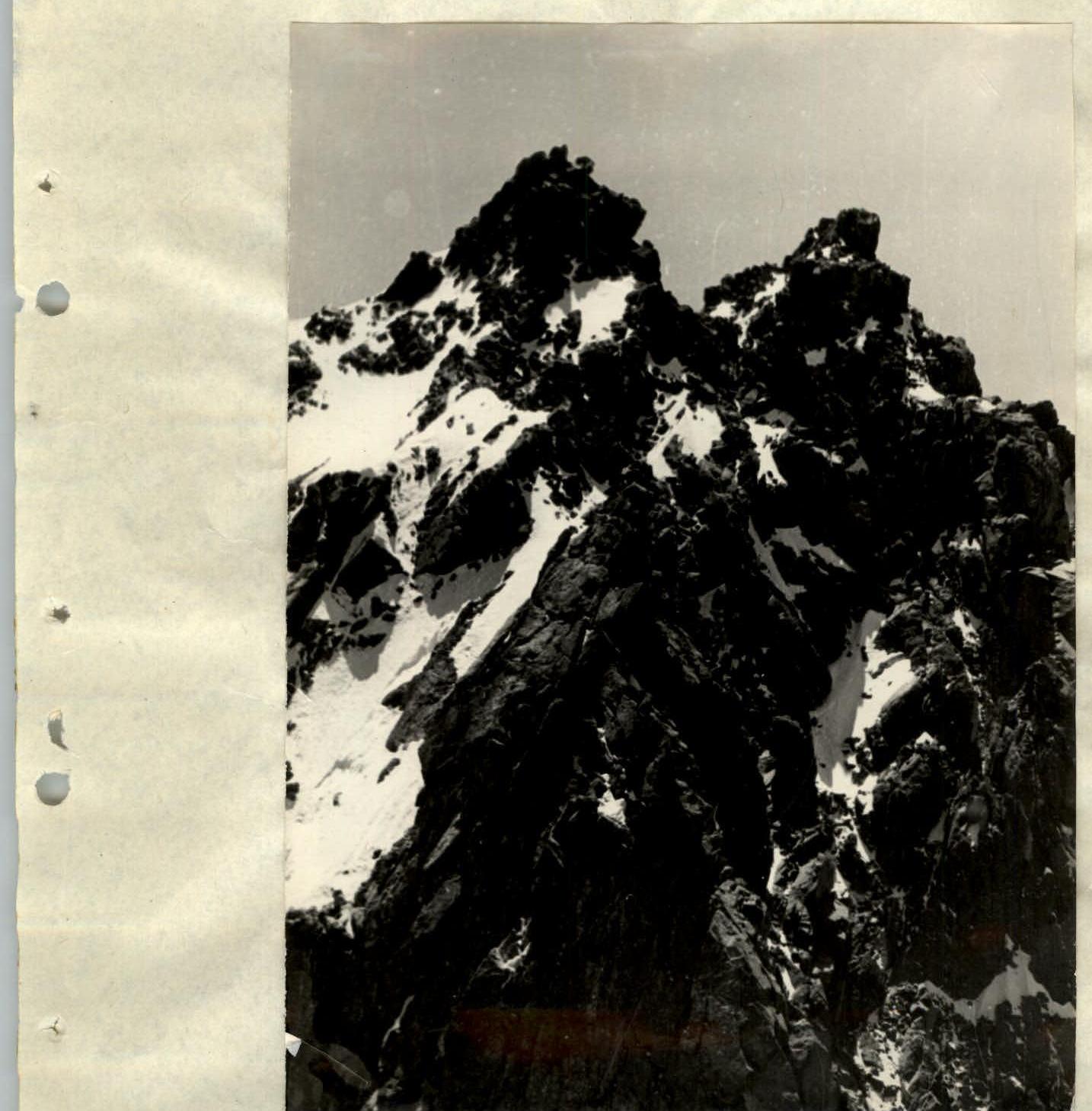
The southern peak (4200 m) of "Kompartii Kazakhstana".
View of the firn field of the May-Bulak glacier from the peak "40 years of Kompartii Kazakhstana".