PASSPORT
- Climbing category: rock climbing.
- Climbing area: Western Sayan, Ergaki ridge.
- Peak: Zub Drakona (Dragon's Tooth), 2021 m, via the edge of the S wall.
- Proposed category: 5A, first ascent.
- Route characteristics: elevation gain: 400 m; route length: approximately 600 m; length of sections with 5–6 category difficulty: 200 m; average steepness: 56°; steepness of the wall section: 67°.
- Pitons used: rock pitons: 6; chocks: 69.
- Climbing time: 11 hours.
- Overnights: none.
- Participants: Kokhanov Valeriy Petrovich, MSMSK, Krasnoyarsk Kuznetsov Aleksandr Vladimirovich, MS, Krasnoyarsk
- Team coaches: Zakharov Nikolay Nikolayevich, Krasnoyarsk Balezin Valeriy Viktorovich, Krasnoyarsk
- Approach, summit, descent: June 26, 1987.
- Krasnoyarsk Kraysportkomitet.

General photo of the peak. Taken on June 25, 1997 — the team's route.
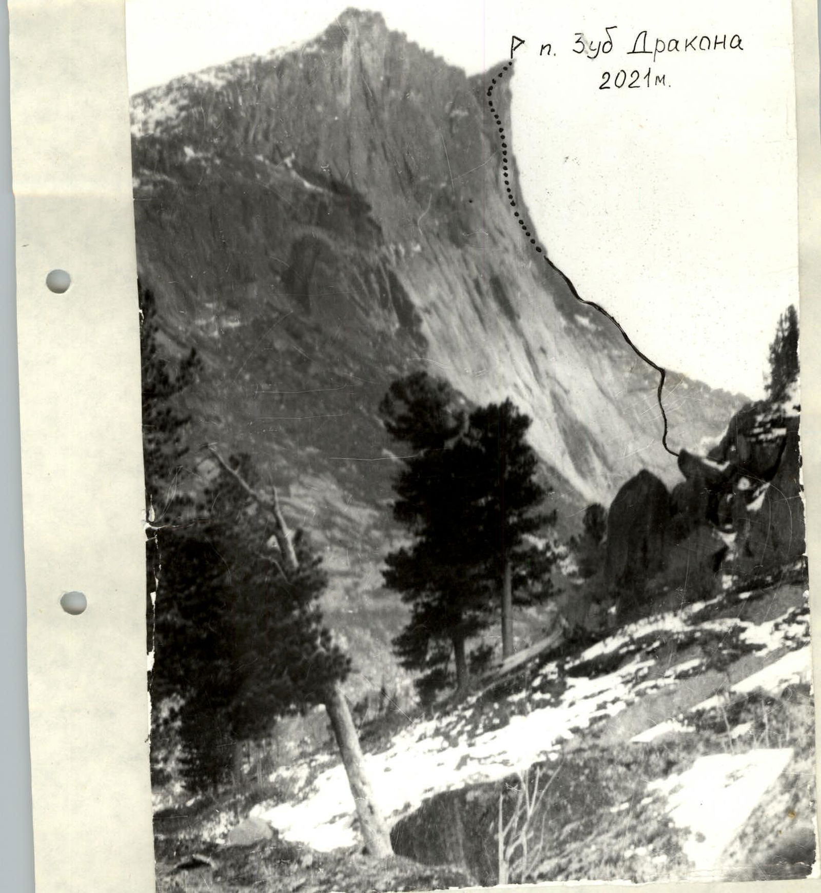 Photo of the wall from the left.
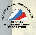
Zub Drakona peak 2021 m, June 26, 1997.
Climbing Area Overview
The Ergaki massif is located in the central part of the Western Sayan. The massif stretches approximately 80 km from west to east and is about 70 km wide. The summer is cool here:
- Prevailing daytime temperatures in July are +10…+16 °C
- Nighttime temperatures are +2…+6 °C
- Precipitation mostly falls in the form of heavy rain with thunderstorms, sometimes as snow.
The Ergaki massif can be reached via the Usinskiy tract road, which connects the cities of Abakan and Kyzyl. Both cities have airports, and Abakan is also connected by railway.
From the base camp at Svetloe Lake, the entire approach takes about four hours. It takes one hour to reach Zolotarnoe Lake via Lugovoy Pass, then along the left bank of the lake to Pikantny Pass. From here, the entire path to the route is visible.
When descending into the Northern Cirque, be particularly cautious — slippery rocks, loose scree!
After descending from the pass, follow the northern slopes of Dinosaur peak to the lakes under the South wall of Zub Drakona peak. There's a good meadow for camping just before the second lake.
For the return journey, it's more logical:
- Pass the second lake.
- Climb up the left couloir between the main peak and the 1st and 2nd towers of Dinosaur peak.
- After climbing the couloir (40 minutes from the campsite) — descend to Pikantny Pass.
- 15 minutes descent.
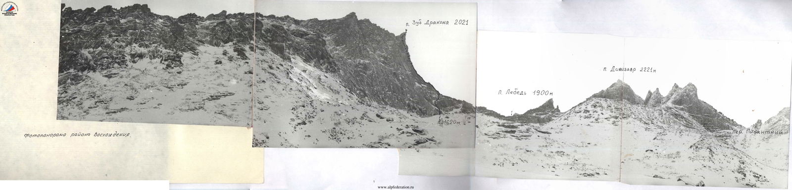
Photopanorama of the climbing area.
| Section | Pitons | Chocks | Length | Steepness | Section Category |
|---|---|---|---|---|---|
| R0–R1 | 4 | 40 m | 60° | 4+ | |
| R1–R2 | 3 | 40 m | 50° | 4 | |
| R2–R3 | 2 | 45 m | 50° | 3+ | |
| R3–R4 | 3 | 30 m | 65° | 4 | |
| R4–R5 | 120 m | 30° | 3 | ||
| R5–R6 | 14 | 2 | 40 m | 60° | 5+ |
| R6–R7 | 7 | 40 m | 55° | 5 | |
| R7–R8 | 6 | 11 | 40 m | 85° | 6 |
| R8–R9 | 8 | 40 m | 75° | 5+ | |
| R9–R10 | 15 | 3 | 40 m | 70° | 5+ |
| R10–R11 | 50 m | 60° | 4 | ||
| R11–R12 | 2 | 60 m | 25° | 2 |
Route Description
Section R0–R1. The beginning of the route is complicated by a cairn. Smooth slabs, walls. Cracks are filled with earth and grass. Exit to a grassy ledge.
Section R1–R2. Along the ledge to the left for 10 m, then up a steep monolithic slab to a ledge.
Section R2–R3. Along the ledge to the right, then up a chimney with a plug.
Section R3–R4. Exit to the ridge via an inside corner.
Section R4–R5. Monolithic ridge, solid rocks.
Section R5–R6. Large monolithic inside corner, good cracks for chocks.
Section R6–R7. Inside corner leads to a convenient ledge.
Section R7–R8. The most challenging section of the route. Initially, an inside corner turning into a chimney, then left onto the wall via a thin crack on an ITO, and through a small cornice to a platform.
Section R8–R9. Inside corner with a cornice, then to the right via an inside corner to a good platform.
Section R9–R10. Wall and inside corner, to a good spot for an overnight stay.
Section R10–R11. Wall, then "ram's foreheads" leading to the pre-summit ridge.
Section R11–R12. Ridge, summit.

Technical photo of the route, taken in February 1997.

Technical photo of the route. Taken in February 1997 from the 3rd ridge of Dinosaur peak.


