
Ascension certificate
-
Eastern Sayan, Tunkinskie Goltsy range, Baruun-Khandagai river gorge. Section number according to classification table 6.1.2 — Charskie Zori, 2920 m (summit coordinates: 51°55′24.54″ N 102°10′90″ E), via south-eastern counterfort of western ridge
-
Difficulty category: proposed 4B cat., first ascension
-
Nature of the route — rocky.
-
Route elevation difference: 400 m
Route length: 550 m. Length of sections: V cat. difficulty — 60 m, VI cat. difficulty — 85 m. Average steepness: wall section of the route — 80°, entire route — 60°
- Pitons left on the route: total 0
Used on the route: anchor protection: 3/0, nuts 29/0, bollard pitons 0 / 0, none were used on the route
- Team's locomotion hours: 5 h 40 min, No nights spent on route
- Team lead: Glazunova Ekaterina Georgievna (1st sp. discharge)
Participant: Glazunov Evgeny Vladimirovich (CMS)
- Coach: Glazunov Evgeny Vladimirovich (CMS)
Entering the route from BL: 8:00, July 11, 2012. On the summit — 15:30, July 11, 2012 Returning to BL — 20:30, July 11, 2012
Region review, sports characteristics and tactical actions of the team
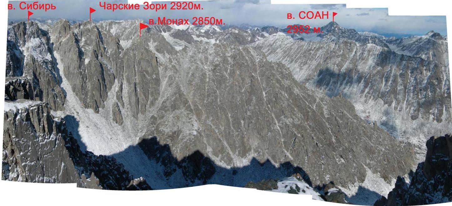
Charskie Zori peak is located in the upper reaches of the Baruun-Khandagai gorge, Tunkinsky range of Eastern Sayan, between the massif of Zima and Sibiryak peaks (to the West) and Monakh peak (to the East).
No classified routes have been laid on it. The path we chose for the first ascension runs along a characteristic counterfort from the hanging cirque of the Kupol peak.
The counterfort is monolithic with a ярко выраженным relief in the form of vertical internal angles. The route is uniform, with two characteristic key sections.
According to the team's estimates, the route corresponds to similar routes in Eastern Sayan of the same difficulty category.
scheme of Khandagai gorge and approach path to the route:
- 3
- 4
Photopanorama of the region (shot from Kupol peak)
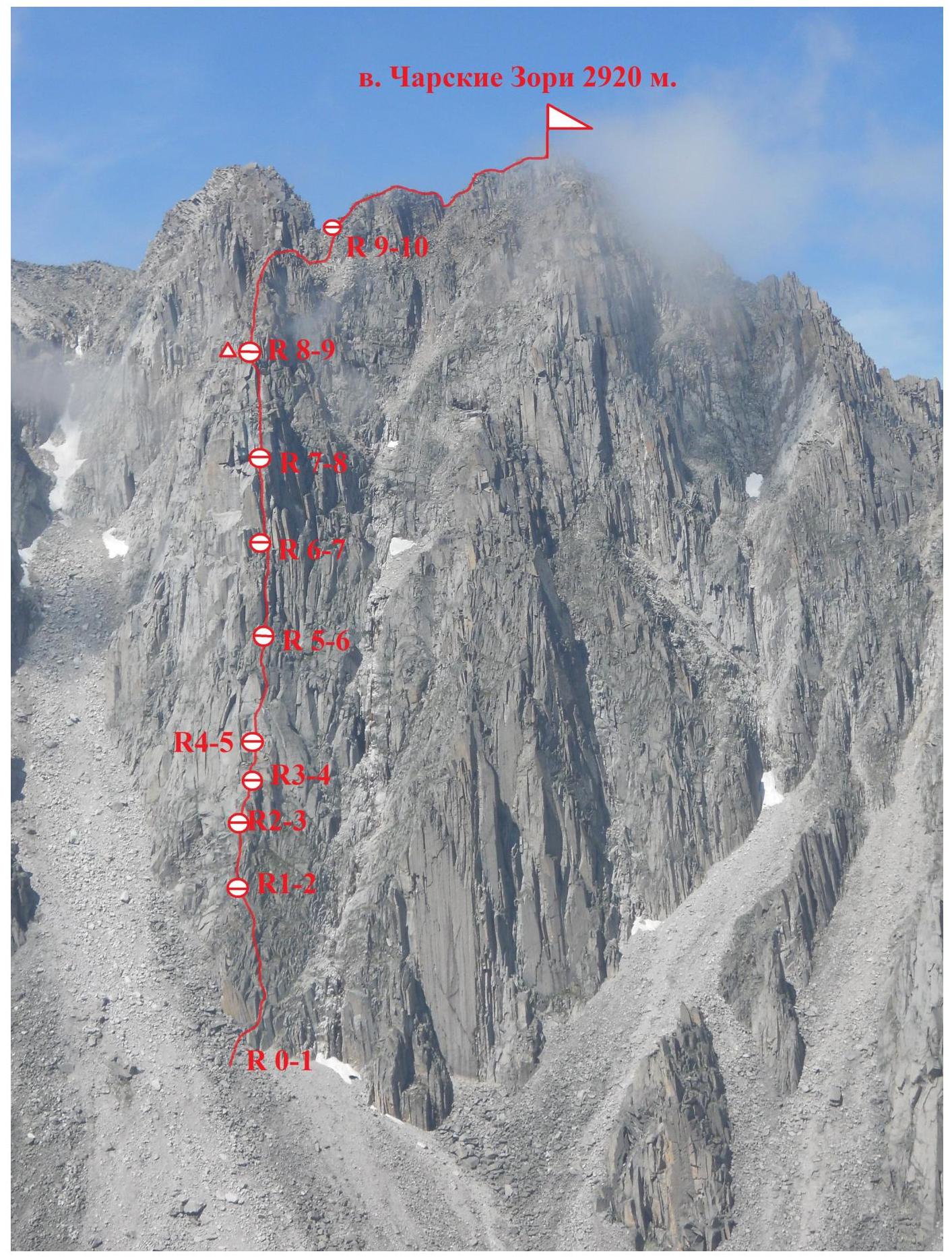
Route scheme by sections
 Profile
of counterfort
Profile
of counterfort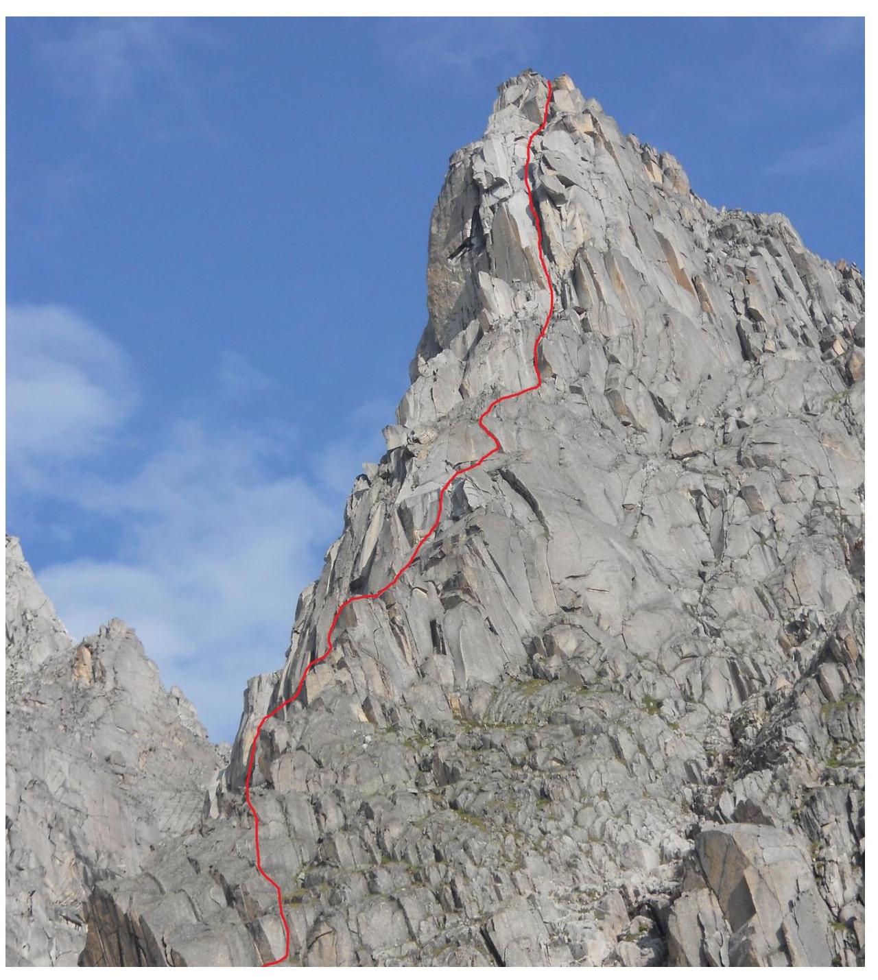
9 Scheme
UIAA
Description of the route by sections R0–R1. Start of the route from the lowest part of the counterfort, from under the yellow overhanging wall with vertical cracks (photo 1). Move behind the bend to the right along a wide crack and system of shelves. Direction of movement is towards the ridge of the counterfort. (60 m, 55° III–IV)
1–2 Along the ridge of the counterfort, overcoming walls head-on. Movement up to the monolithic wall on the ridge. (30 m, 55–60° III)
2–3 Then move to the left side of the counterfort, bypassing the monolithic wall on the left (photo 2). Movement along a shelf-terrace to an internal angle, from which to return to the ridge of the counterfort (photo 2.1). (60 m, 60° IV)
3–4 Upwards, slightly to the right through a series of walls and shelves, to a narrow inclined ledge, along which to traverse to the left for 5 m to a wall with a vertical crack. (45 m, 70° IV)
4–5. Along the vertical narrow crack, ascend the wall (photo 3), then slightly to the right along boulders and an internal angle to reach a large boulder at the base of a vertical internal angle with a wide crack (photo 4). (50 m, 70°, V)
5–6. Move along the angle (first key section), the crack is wide (photo 5), so we protect ourselves with camming devices on the left part of the slab, where the crack is narrower. Then the climb becomes easier, to a shelf on the left of the base of a characteristic large chimney. (50 m, 90°, VI)
6–7. From the belay station, along the chimney (second key section), careful climbing, live rocks are encountered. This is the only section where we needed anchors (photo 6). Ascend the chimney, then a series of walls — shelves. Belay station on a small shelf at the base of "reddish" rocks composed of live boulders. (55 m, 85° VI)
7–8. Along the wall composed of live boulders (photo 7), very carefully, as boulders may fall out! — reach a large shelf, from which to move upwards along a chimney with a series of walls to the summit of the bastion. Control tour. (60 m, 80° V)
8–9 — simultaneous movement along rocks of average difficulty in the direction of the ridge. In the middle of the section — a vertical wall, climbed by friction. Further, simultaneously, sometimes alternately, along easier rocks, we reach the Western ridge of Charskie Zori.
(120 m, 55°, III–IV)
9–10 — along the ridge, simultaneously, through small walls, ascend to the summit.
(150 m, 40°, II)