Ascent Log
Ascent Category: Technical Region: Eastern Sayan, Tunka Ridge Route: North edge of the North tower of Trekhglaaya peak 2511 m ASL Ascent Description: elevation gain: 670 m, average steepness: 50°, difficult section: 220 m. Pitons driven: rock: 17 pcs, ice: none, bolt: none Number of travel hours: 14 h. No overnight stays on the route. Team: Sports club "Bratsk" Leader: Trubnikov V. I., Master of Sports of the USSR Participants: Moskalev G. A., Candidate for Master of Sports, Kriulin V. K., 1st sports category, Koltygin S. F., 2nd sports category Team Coach: Trubnikov V. I. Ascent Date: May 12, 1976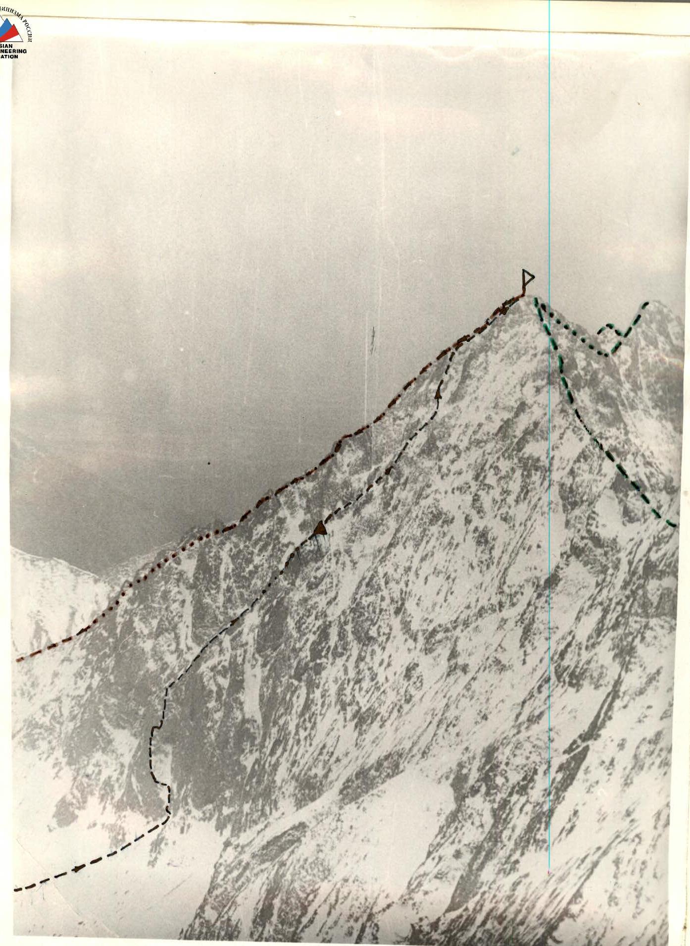
| Route traversed by the group | |
|---|---|
| === | Route 4A cat. diff. (traverse) |
| === | Route 2B cat. diff. via E. edge |
| control cairn |

Map of the ascent area. Table of route section characteristics.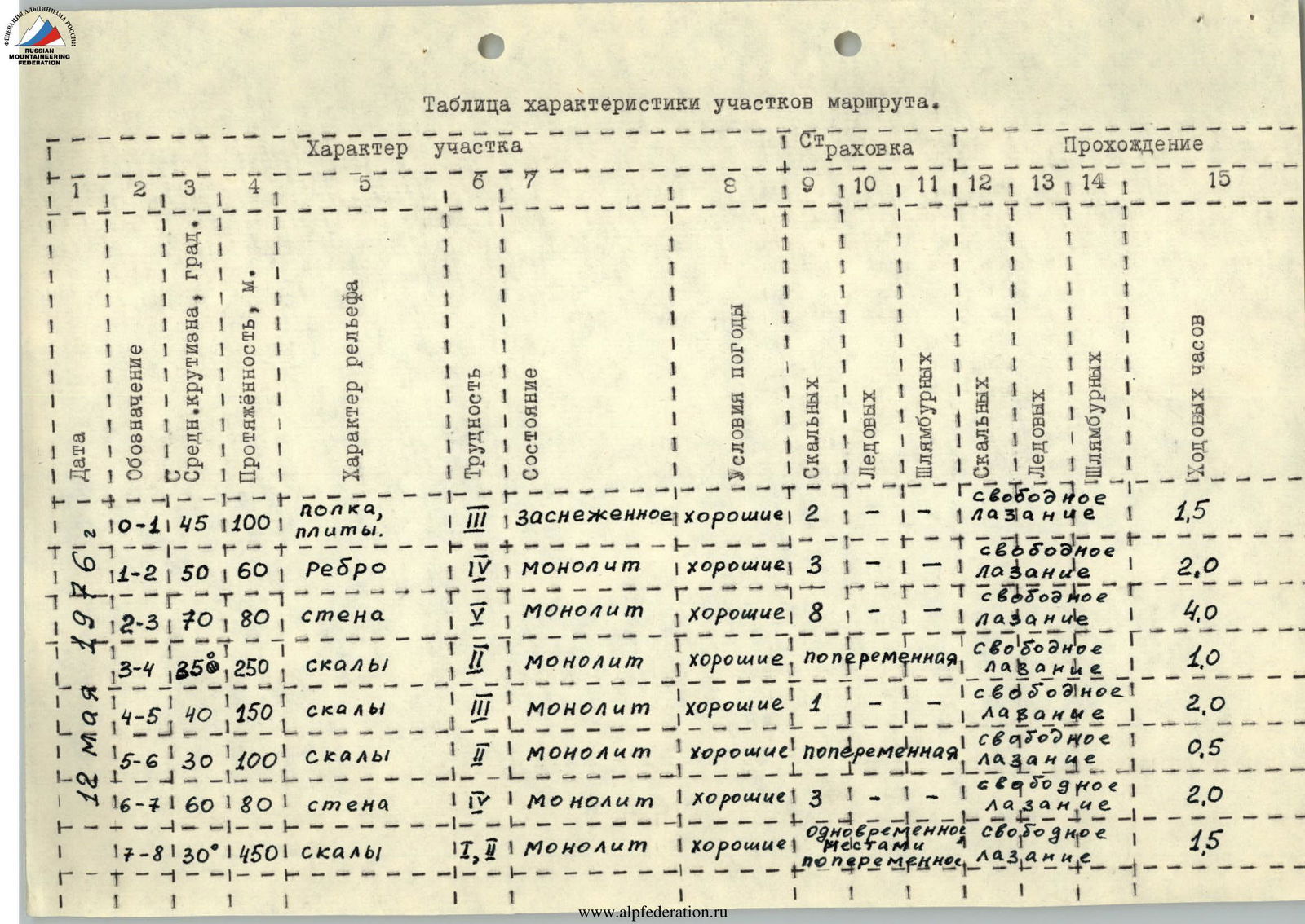
Report
on the ascent of the North tower of Trekhglaaya peak via the north edge (first ascent).
Description of the Ascent Area
Trekhglaaya peak is located in the southeastern ridge of the Tunka Ridge in the Eastern Sayan, in the upper reaches of the Kyngarga gorge. A ridge extends from the main ridge towards the peak, crowned with a summit featuring steep walls facing the North and East cirques. There are classified routes of 4A, 4B, 2B, and 1B categories of difficulty to Trekhglaaya peak from the East cirque. There were no routes to the peak from the North cirque.
The approach to the base camp for the ascent goes from the Arshan resort along the Kyngarga gorge on a trail to an old hunting lodge, located at the fork of the gorge into several branches, with the widest branch turning west towards the East cirque of Trekhglaaya peak. The approach from the resort to the base camp takes 4 hours.
The base camp is located in the forest zone. The area is characterized by unstable weather conditions with a fairly harsh climate. The summer is short, and the upper forest boundary in the gorge is at an altitude of 1800 m above sea level. There are no glaciers in the gorge. In summer conditions, the routes are rocky; in winter, they are combined with sections of regelation ice.
Description of the Ascent Route
From the base camp, along a trail on the right (in the direction of travel) slope of the gorge, overcoming a steep ascent, exit into the North cirque. Upon entering the cirque, the forest zone ends.
Along the ridge separating the North and East cirques, approach the North edge.
The beginning of the route is at a wide inclined ledge, narrowing at the bottom and bounded on the left by a rock edge of average steepness 40–50°. To the right and above are sheer walls.
Entry onto the ledge is by traversing left into the narrowing part of the ledge. Then proceed either:
- along the ledge upwards, sticking to the right side (pitons for protection on the wall to the right),
- or along the edge, which can be reached after the first rope length of movement along the ledge.
(The route with an exit to the edge is recommended, as rockfall from the wall in the upper part of the ledge is possible. The upper part of the ledge - see photo #3). Exit to the edge after traversing the ledge via rock slabs of medium difficulty with piton protection (1st rope length).
Then directly up the edge to the base of a characteristic 80-meter rusty wall (1.5 rope lengths). The section is of medium difficulty with two walls: the first is 8–10 m, the second is 6–7 m. Climbing is difficult. Proceed with piton protection.
(Exit to the edge and view of the first wall - see photo #4).
The rusty 80-meter rock is climbed either:
- directly upwards (loose rocks, hazardous for belayers below!),
- or by traversing right along difficult rocks (20 m) and then
- upwards along the wall to exit onto the top of wall 3 (65–70 m).
The average steepness of the wall is about 70°, with sheer sections. Proceed with careful piton protection. Then along simple rocks (about 250 m) on the right side, ending in a sheer wall (alternate belays, partly simultaneous), approach under a dark-gray wide rock belt. The rock belt (about 150 m) is overcome by going left upwards (piton protection) to exit onto a pronounced ridge of the north edge. Here is a control cairn. Movement along the ridge is mostly simultaneous, partly alternate, with overcoming 2–3-meter walls under a gendarme, which is climbed left upwards along a pronounced ledge (about 80 m, piton protection).
Further along the route (about 300 m) to the East ridge, there are no technical difficulties. Movement is mostly simultaneous. Exit to the summit via the East edge (about 150 m).
Descent is along the East edge into the East cirque via route 2B category of difficulty. The group left the base camp at 4:30, approaching the route took 1.5 hours. Climbing the wall was completed at 13:00, and the summit was reached at 20:00. The group returned to the base camp at 23:00.
17 pitons were driven by the group on the route. In short daylight conditions (autumn, winter), completing the route without an overnight stay seems doubtful; possible overnight stay locations with tent setup appear only after passing the wall, but when climbing the route in summer conditions, there will be no water on the route.
It is recommended to start the route not later than 6:00 am with a group of no more than 6 people.
RECOMMENDED EQUIPMENT FOR A GROUP OF 4:
1. Main rope - 2×40 m 2. Rock pitons - 10–15 pcs 3. Hammers - 2 pcs 4. Vibram soles - 1–2 pairs 5. Insulated boots - 3–2 pairs 6. Tent The group believes that the above-described route should be classified as 4B category of difficulty.
TEAM LEADER V. Trubnikov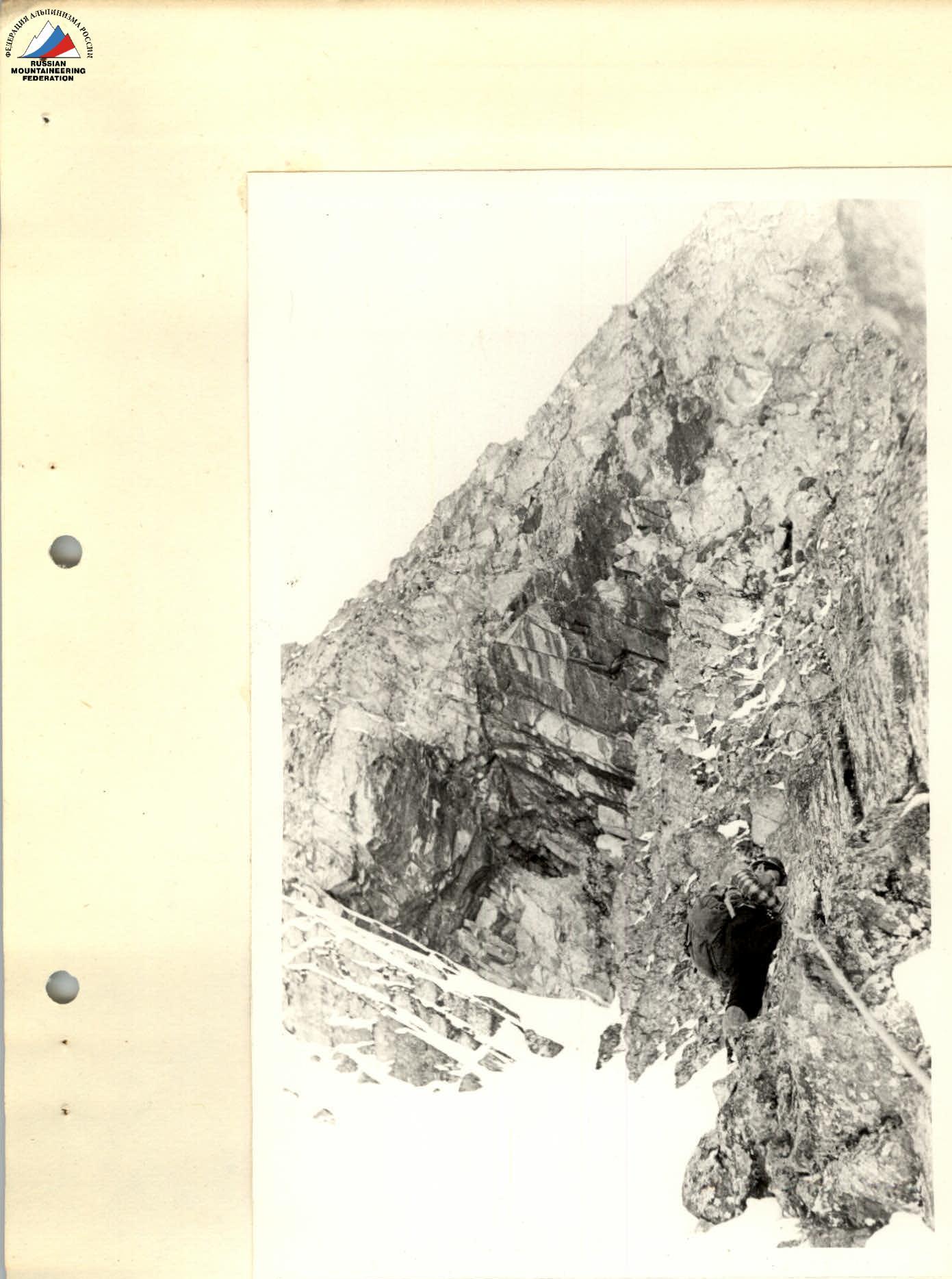
Photo 3. Lower part of the ledge (section R0–R1 in photo 1)