Ascent Report
To the summit of Trekhglavaya (2611 m) via the right buttress of the Eastern wall (first ascent), Eastern Sayan Range, November 2011
Irkutsk — 2011. Ascent Passport
Region — Eastern Sayans, Tunkinskie Goltsy, Kyngarga gorge.
Summit — Trekhglavaya Severaya 2611 m. Route — Right buttress of the Eastern wall. Proposed category — 3A. First ascent
Route character — rock. Route characteristics:
- elevation gain 661 m,
- route length about 1170 m,
- average slope 51°.
Left on the route — pitons 0. Used pitons on the route: 23, including:
- "slings" — 16,
- bolt pitons — 0,
- including ITO — 0.
Number of climbing hours — 11 hours, days 1. Leader — Perepechin Alexander Alexandrovich — 1st category. Participants — Gichev Denis Vladimirovich — CMS, Lebedev Anton Dmitrievich — 1st category. Departure date:
- On the route November 5, 2011 at 8:00
- On the summit November 5, 2011 at 16:00
- Return to base camp — November 5, 2011 at 19:00
Route description. Approach to the route from the cirque, along the talus slope to the base of a pronounced marble counterfort, to the left of a deep narrow couloir. The start of the route is directly at the base of the counterfort, along a wide ridge.
R0–R1. Along a wide ridge with destroyed snow-covered rocks 35° to the beginning of the "ram's foreheads". 200 m, 1+
Sect. 1–2. Along steep "ram's foreheads" on the edge of the counterfort 30 m, then along a sharp ridge to the next series of "ram's foreheads" 45 m, behind the "ram's foreheads" along a steep sharp ridge to a ledge under an oblique internal angle. Insurance through ledges. 40 m. 45°, 2–
Sect. 2–3. Along an oblique internal angle 45°, 25 m, bypassing a bastion to the right and approaching the wall 10 m, 65°. Along the wall straight up to the top of the bastion and then along the ridge — exit to a comfortable ledge. Insurance through pitons and slings. 45 m, 65°, 3+
Sect. 3–4. Along a sharp ridge to a large ledge on the ridge of the counterfort under the next steep bastion, 30 m. 35° 2+
Sect. 4–5. From the ledge up 15 m along a vertical wall, then along steep inclined slabs to the top of the bastion 50 m. 70° 3+. Insurance through pitons and slings.
Sect. 5–6. Further along the edge of the counterfort, under a series of inclined slabs, to the right of the ridge 50 m. 45° 2+
Sect. 6–7. Movement along inclined slabs 30 m, under a not steep but long wall 12 m. Along the wall straight up to the base of a wide chimney. 45 m 50° 3–
Sect. 7–8. Along the chimney (inside the chimney) exit to an internal angle and along the angle to the ridge of the counterfort. 50 m 45° 2+
Sect. 8–9. Along the ridge of the counterfort under the next internal angle. 40 m 45° 2+
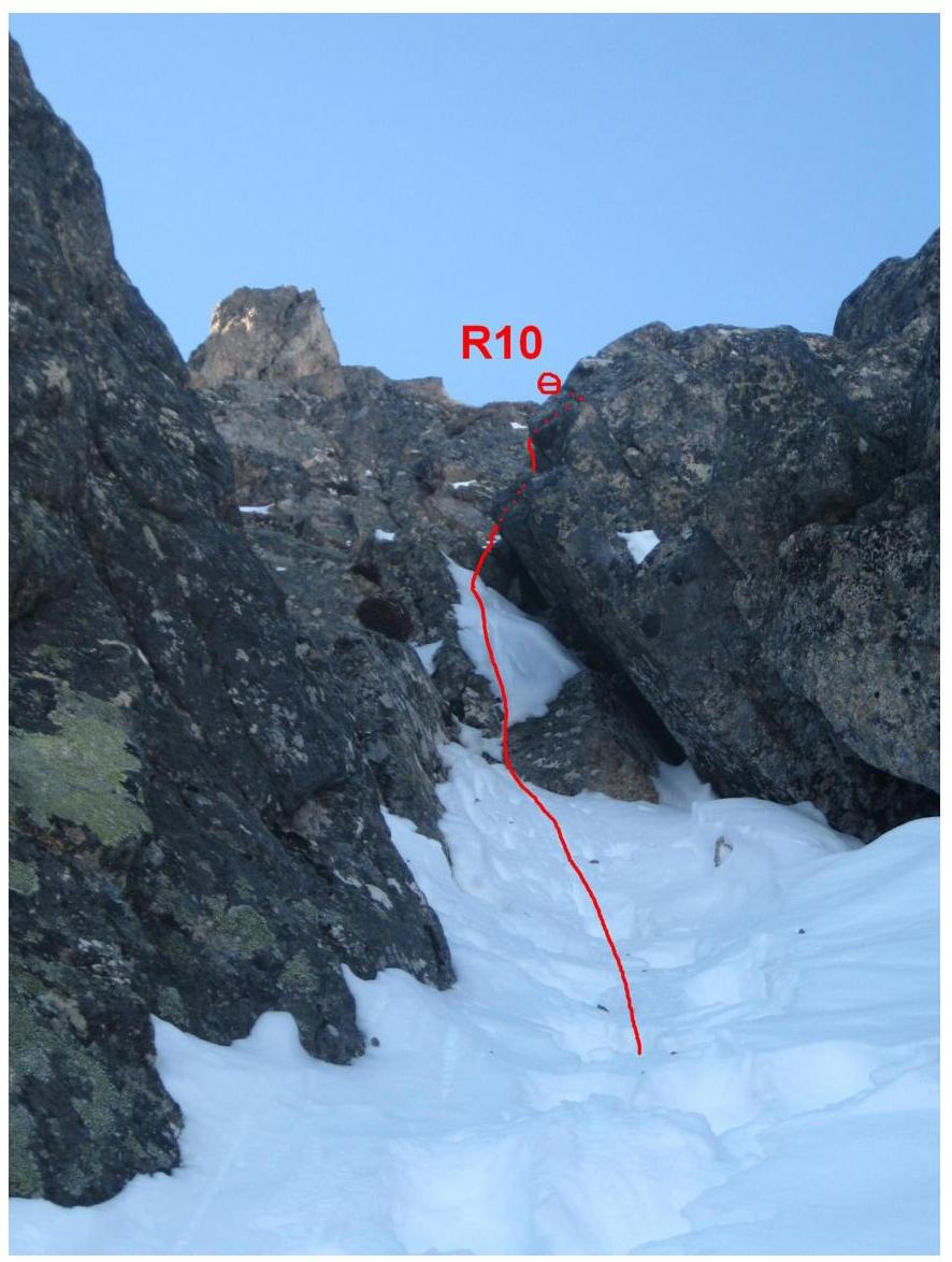
Sect. 9–10. Along an internal angle, to the right of the ridge, exit to a narrow chimney, having passed which we approach under a long inclined snow-covered slab. 50 m, 50°, 3–.
List:
- Insurance through slings.
Sect. 10–11
- Along an inclined slab to an internal angle 7 m
- Along the angle to the base of the wall
- 40 m 45° 3–
- Insurance through ledges.
Sect. 11–12
- Along the wall up 12 m, exit to the ridge of the counterfort
- Along the ridge, under a series of "ram's foreheads"
- 50 m 50° 3Б
Sect. 12–13. Through the "ram's foreheads" exit to the ridge of the counterfort and along it to the junction with the northeast ridge of the summit Trekhglavaya Severaya, along which the 2B category route passes. 45°, 45 m, 2+. Sect. 13–14–15–16. The route coincides with the 2B category route to Trekhglavaya Severaya. Characterized by movement along a steep and sharp ridge, with a series of short but quite complex walls of 2–3 m. At the end of sect. 15–16, the route exits to the dome of the summit Trekhglavaya Severaya and along simple terrain 1+, 15 m, to the summit. 160 m, 45°, 3–
Descent from the summit is possible via two options:
-
Descent along the northeast ridge:
-
Descend from the summit along the northeast ridge to point R13.
-
Further follow the ridge, bypassing high black "gendarmes" to the right.
-
Continue to a pronounced saddle.
-
From the saddle, enter a steep couloir and descend along it to the cirque.
Attention!
-
The couloir is very avalanche-prone in winter and during the off-season!
-
In summer, when descending along the couloir, it is necessary to organize three rappels along vertical walls 5–7 m high.
This option is convenient in case of an emergency during the ascent, as it can be descended from almost any point on the route (up to point R12).
-
2nd option — involves descending by continuing along the 2B category route (traversing Severaya and Central towers), and descending from the Central tower of Trekhglavaya along the 1B category route. This option is longer but much safer and easier. The main difficulty on this route is overcoming a steep (90°) section of the ridge, about 5 m, when exiting to the Central tower. This descent option is used by all participants who have made ascents along the Afanasiev (4B) and Akhmedzhanov (3A) routes to the Severaya tower of Trekhglavaya.
It should also be noted that the route passed is much more logical and technically challenging than the neighboring Akhmedzhanov 3A route (along the central counterfort), as noted by all participants of this first ascent, as well as climbers who ascended along the right counterfort of the Eastern wall of the Severaya tower of Trekhglavaya mountain, but did not submit information about their ascents. And the fact that after reaching the summit, one still has to traverse the Severaya and Central towers of Trekhglavaya mountain for descent, makes it a strong credit for this region.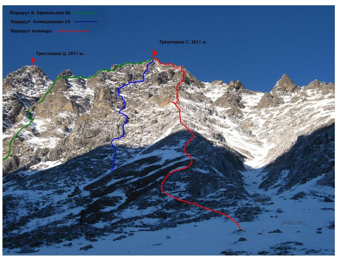 Route scheme in UIAA symbols
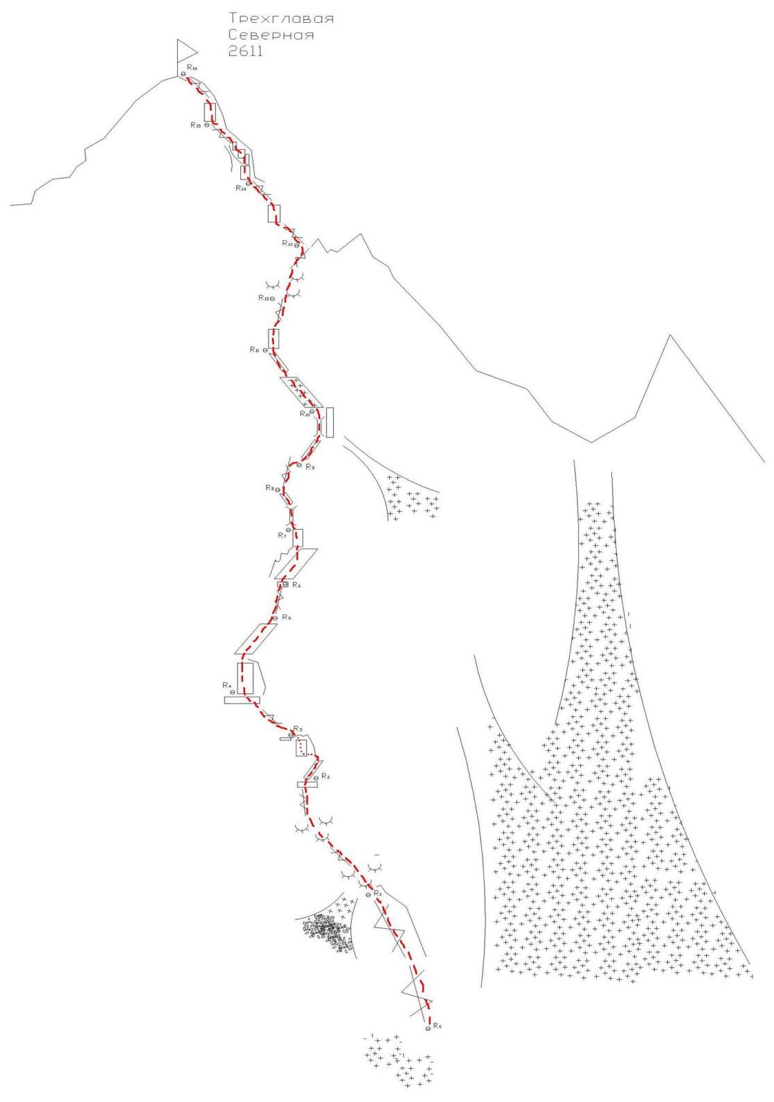
 □
□