
SOAN Peak (2952 m)
The route along the South wall (approx. 5A cat. diff.) - SOAN peak (Siberian Branch of the Academy of Sciences) is located in a lateral spur of the Tunkin Range of the Eastern Sayan Mountains between the Zuun-Khandagai and Talta rivers.
The most studied and interesting mountaineering routes to SOAN peak start from the Zuun-Khandagai valley.
The Sayan rivers are frozen from November to mid-May. Ice fields and icings remain until mid-July, and snow persists in some valleys until August.
Numerous high-altitude lakes are completely ice-free by the second half of July, are deep, and lifeless.
There is no glaciation in the Sayan region. The most favorable months for ascent are:
- June,
- July,
- first half of August.
Approach
From Irkutsk to Arshan resort by bus - 218 km. From Arshan resort to the Zuun-Khandagai valley (west along the mountain line) on foot or by car - 12 km. Up the Zuun-Khandagai valley to the first left (orographic) tributary (forest boundary, base camp) - 9 km.
The height of the base camp is 1890 m.
Group composition:
leader B. M. Belousov - 2nd sports category + 4A level + 4B level A. N. Kodachilov - 2nd sports category + 4A level + 4A leader + 4B leader V. N. Popov - 2nd sports category + 4A level + 4A level + 4A leader + 4B level + 4B level + 4B leader + 5A level V. F. Yudalievich - 2nd sports category
Route Description
along the South wall of SOAN peak, 2952 m. Eastern Sayan, Tunkin Range.
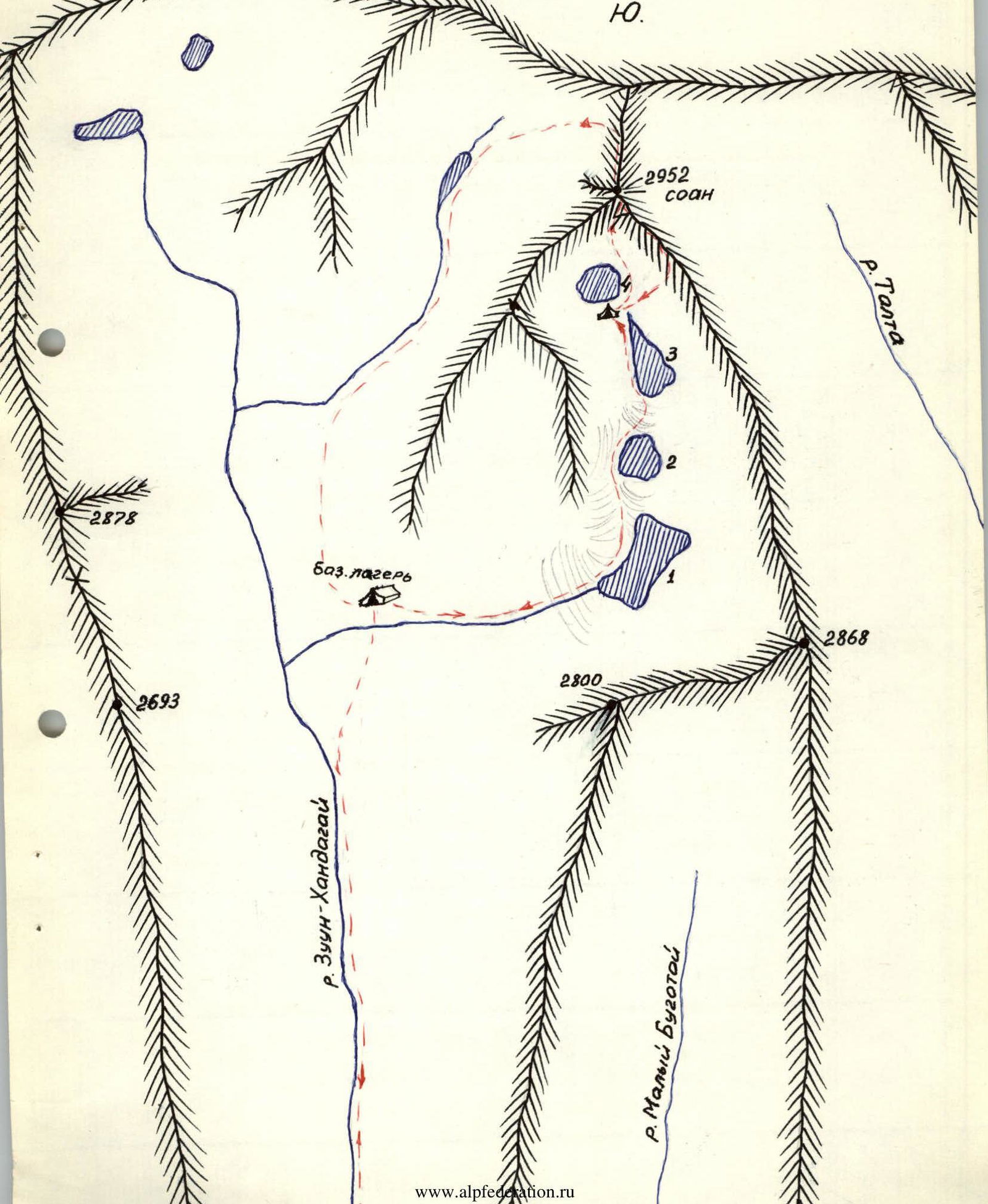
SOAN peak is located at the source of the Zuun-Khandagai river. It is convenient to set up a base camp at the confluence of the first left (orographic) tributary and the Zuun-Khandagai river, at the forest boundary. The height of the base camp is 1890 m. The path to the assault camp goes up the tributary valley along grassy slopes and large scree with rock outcrops to the last 4th lake (see map).
It is convenient to locate the assault camp on the ridge between the lake under the wall and the third lake. From here, the entire route is clearly visible. The height of the assault camp is 2500 m.
The journey from the base camp to the assault camp takes 3 hours. When choosing the future route, the following ascent option was selected:
- it is necessary to follow the section of the wall located immediately to the right of the central couloir, as it is more monolithic and less prone to rockfall (it is slightly convex) compared to the section of the wall to the left of the central couloir. The ledges and outcrops of the chosen route appear clean and solid. The steepness of the chosen route is approximately 70–80°; cracks for piton placement are visible throughout the route, as well as small ledges for belay station organization. The chosen route appears to be safer from rockfall.
- the route along the section of the wall to the left of the central couloir was not chosen due to the wall's strong fragmentation, the presence of many loose rocks. The ledges and outcrops of the left part of the wall are covered with earth and overgrown with grass, especially in the upper part. During observations along the central couloir and from the left part of the wall, rare rockfall was noted.
- the right part of the wall is steeper, strongly fragmented by numerous overhangs, and has few cracks for piton placement. It is difficult to identify a logical route on the right part of the wall. Map of the SOAN peak area
Section R0–R1
From the assault camp, move to the right around the lake under the wall along medium scree to the beginning of the central couloir of the wall. The central couloir starts from the wall under the summit and runs without bends to the foot of the wall, where it turns into a narrow gully. At the base of the gully, a steep (45°) avalanche cone remains until the end of summer, clearly visible from the assault camp.
Along the avalanche cone with alternating belay, approach the wall, 5–10 m to the right of the central couloir-gully. Here begins the wall route. The rankluft from the avalanche cone is not deep, 1–1.5 m.
Section R1–R2 (photo 1)
Section R1–R2 is traversed by difficult climbing up vertical cracks. Over the 40 m length of the section, the deviation is 4–5 m to the right from the vertical direction. The rocks are difficult, monolithic, with a limited number of holds and footholds.
In the few cracks of the rock monolith, pitons hold very well.
After 40 m, a 0.5 m wide ledge is encountered, where a belay station is organized through a piton-carabiner. On this section, 8 rock pitons were placed for protection. Backpacks on this and subsequent sections (up to section R8–R9) were pulled up with a rope, and to secure them, an additional piton needs to be placed at the belay station. The section is not prone to rockfall.
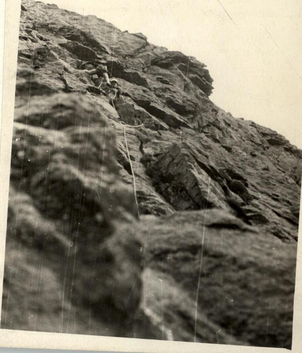
Section R2–R3 (photo 2)
From the aforementioned ledge, belay station, move along the ledge to the right (1.5–2 m) - a small inner corner, 70° steep and 7–8 m long, and climb up with a slight deviation to the right (parallel to the vertical cracks) to a large inclined ledge overgrown with grass. The ledge is 7 m wide, 10 m long, and inclined at 20°. FIRST CONTROL TUR. The length of the section is 50 m. The rocks alternate between difficult (approx. 4 cat. diff.) and medium difficulty (3 cat. diff.). Vertical pitons are mainly used for protection. The average steepness of the section is 70°. 10 pitons were placed for protection.
On this section, there are no suitable ledges for convenient intermediate belay stations. An intermediate belay station can be organized 25 m from the R2 ledge, where the first belay was set up. The intermediate station is a small outcrop where only one person can stand (as shown in photo 2).
The section has several loose rocks, posing a risk of rockfall from careless rope or participant movement.
Section R3–R4 (photo 3)
From the large ledge with control tur №1, the route goes up and left along a small rib and inner corner formed by this rib, 20 m long.
Then the route reaches a very difficult wall ("mirror") and goes vertically up 10–12 m.
From the top of the smooth wall ("mirror"), the route turns right through a vertical outer corner into a small inner corner. Up the inner corner, vertically, after 6–7 m, the route reaches a 0.5 m wide and 1.5 m long ledge.
From the first control tur on the large grassy ledge to this ledge - 30 m. No more than two people can stand on the ledge simultaneously. This ledge was used as an intermediate belay station. From this ledge upwards and slightly left along rocks of medium difficulty, after 7–8 m, the route reaches a 1.5 m wide and 3 m long ledge. A belay station can be well organized on this ledge.
The aforementioned wall ("mirror") is very difficult to traverse. A 4–5 m section in the middle of the "mirror" has a limited number of holds for climbing. There are no suitable spots for piton placement in this section.
The slope of the rock walls is 70–75°. The few available holds and ledges are monolithic. The rocks on this section are not prone to rockfall.
Section R3–R5 (photo 4)
From the ledge, belay station, climb 3 m to a small narrowing inclined ledge (0.5 m wide, 2 m long), then turning into a crack. Along this ledge and crack, move up and right towards overhanging monoliths. The monoliths overhang by about 0.5 m and are approximately 10 m from the ledge. Before the overhanging monoliths, a small inner corner is encountered, which is closed by these monoliths at the top. Move up the inner corner vertically under the overhang formed by the monoliths, then bypass it on the right along the wall. Very difficult rocks. Above the overhanging monoliths, the route goes vertically up and after 15–20 m reaches a 0.7 m wide ledge. The ledge is inclined to the right at 20°, where a belay station can be organized (photo №1, point 5). The wall slope is around 80° in some places. The section is not prone to rockfall.
Section R5–R6
The route goes from the left edge of the ledge vertically up the wall. After 10 m, a small vertical inner corner is encountered. Climb up the corner 8–10 m along rocks of medium difficulty. The upper part of the section also goes vertically up. The rocks in the upper part are difficult, monolithic.
The cracks for piton placement are excellent. On this and other sections, rock pitons 3–4 mm thick are mainly used.
The section ends on a small inclined ledge where 3–4 people can stand. The wall slope is up to 70°. On the ledge is the SECOND CONTROL TUR.
Section R6–R7
Immediately to the left of the ledge, a rib of a huge slab that has broken off is visible. The slab stands firmly. Climb up the right rib of the slab vertically 7 m, then along the crack formed by this slab and the wall, climb up onto the top of the slab. This is another 12 m. From here, the route goes up 3 m and sharply turns right for 6–8 m along difficult rocks. In this place, the wall above the route becomes rounded, and one sees a kind of "bald spot" with smooth vertical walls, so it is necessary to bypass it on the right. Having passed this piece of difficult rocks to the right and crossed the rib, you enter a gentle inner corner with a 20° slope. From the inner corner, climb onto a 2 m high rib and traverse to the right to reach an inclined ledge. The inclined ledge is an unclearly defined inner corner, also inclined to the right. Above the ledge, a small block overhangs - the right edge of the rounded "bald spot" described above. The second inner corner is more inclined to the right, 30°; it is 7 m long and drops off towards the assault camp. The rocks on the section are monolithic, not prone to rockfall.
Section R7–R8
From the inclined ledge, where a belay station needs to be organized, the route goes traversing to the right along an inclined slab with a 40° slope and 12 m long. The slab is wet. In frost, black ice is possible. It is easier to move along the slab under the wall to a large, strongly destroyed vertical inner corner. Up the plumb line of the inner corner, climb under a "plug". The "plug" consists of several small blocks and slightly overhangs. It stands firmly. In this case, it is necessary to reach under the "plug" and use a strength move on hands to get up. Above the "plug", a belay station can be well organized through a piton-carabiner. The length of the route is 40 m. The path from the beginning of the inner corner to the top of the "plug" is prone to rockfall during snowmelt or rain, or with rough passage. The rocks are of medium difficulty, wet, with many loose stones. There are cracks for piton placement.
During snowmelt or in case of rock icing, it is possible to climb from the belay station - the inclined ledge in front of the wet slab, straight up, i.e., along the right rib of the rounded "bald spot". In this case, the use of alpine ladders may be necessary. The detour is technically very complex. Further, the route will go along an inclined sharp rib, flattening out in the upper part to a transverse ridge (point R9).
Section R8–R9
Above the "plug", the inner corner widens and flattens, turning into a strongly destroyed couloir. Climb up, sticking to the left wall, as on the right there is a gully where stones will fall if dislodged. Move very cautiously; many loose stones lie around.
In the upper part, the ascent occurs along the left rib of the inner corner, i.e., at the top, it is necessary to exit onto the left small wall, which drops off to the other side, forming a kind of narrow horizontal rib. Along this rib, and then along small outcrops of the monolith, the route exits onto a transverse ridge (relative to the direction to the summit), oriented in an easterly direction.
On the ridge is the THIRD CONTROL TUR.
Further:
- in the direction of the summit, the path drops off with a wall into a small pre-summit cirque, which below turns into the central couloir seen earlier.
- the route will go to the right along the ridge and merge with the Southeast ridge route.
- Belay on the section is alternating through numerous outcrops.
Section R9–R10
From control tur R3, move to the right along the ridge towards the Southeast ridge. First, along the top of the ridge for 6–8 m, then to the left of the ridge along ledges with good holds until, after 20 m, you exit onto a flat stone 4 by 7 m. Here the route merges with the Southeast ridge route. Belay is organized alternating for outcrops. There is a good area for overnight stay, allowing for a tent to be set up.
The further route will go directly along the narrow Southeast ridge, without spurs. From the flat stone, descend into a small depression 1.5 m deep, then climb up a 4 m high vertical wall (wall 1, see profile scheme of the ridge). The rocks of the wall are of medium difficulty. To the left and right are sheer drops.
Further, above the wall, the route goes straight along the ridge, consisting of a monolith and blocks. Belay on the section is alternating for outcrops.
The visible small gendarme (in photo D, it appears as the highest point) is bypassed on the left along easy rocks. Then the route enters the ridge again, somewhat widened in the form of inclined small areas.
Section R11–R12
The widened ridge ends with a climb (according to the profile scheme, wall 2) with difficult climbing straight up. To the left, the wall has a steepness of 60–65°, and to the right, it drops off sheer. It is necessary to pass wall 2 on the left along rocks of medium difficulty with piton placement for protection.
First, wall 2 is somewhat traversed (about 10 m), then exit up to the ridge vertically. The wall is monolithic, and the few available holds are firm.
After the wall, there is a narrow horizontal ridge. Directly on the ridge is the FOURTH CONTROL TUR, which cannot be bypassed. The ridge is monolithic, without outcrops. To the left and right are sheer drops.
Belay on the ridge is organized alternating through a piton-carabiner.
Starting from section R9–R10 and further to the summit, the risk of participants being hit by rockfall is eliminated.
Section R12–R13
From the tur, the narrow ridge after 12–15 m somewhat widens and becomes more fragmented. Here a ledge is encountered where a sitting overnight stay can be organized for 4–6 people.
After the ledge, the route encounters:
- a huge block with a crack along the ridge, which needs to be climbed (height about 3 m) and moved straight along the block.
Further:
- the ridge becomes strongly fragmented again and consists of large stones in the form of blocks.
- after the fragmented ridge, 40 m from the block with a crack, there is a climb up a flat slab at an angle of 35–40° and 12–14 m long, overcome by easy climbing.
Features of the climb:
- monolithic, with firm outcrops.
- belay is alternating through outcrops.
After the climb, the route goes along a fragmented ridge consisting of blocks to a small ledge 1.5 m wide and 4 m long. The ledge is fenced off from the east (from the Talta valley) by a 2 m high wall. Here, at the end of daylight, a sitting overnight stay was organized.
Section R13–R14
From the ledge, the ridge climb begins immediately.
The left face is 70° steep, the right - 30°.
From the ledge, it is necessary to:
- climb onto the ridge,
- move to the right gentle plane,
- move up along it.
Overcome by easy climbing with alternating belay.
Further, the route goes along the ridge, which has small climbs and descents. The ridge is not wide but strongly fragmented. Throughout the ridge part of the route, the width of the ridge varies from sharp to 10–12 m. To the left and right, the ridge drops off with walls.
60 m before the summit:
- the ridge widens,
- turns into a large, coarse scree of reddish-brown granite.
The summit is located on a gentle area consisting of coarse and medium scree.
The ascent took 14–15 hours.
Descent
- To point R10, the descent follows the ascent route.
- Further - along the Southeast ridge route. (Approx. cat. diff. of the Southeast ridge is 3A in summer conditions.)
- Below point R10, a wall 17–20 m high with a crack is encountered. The steepness of the wall in the lower part is up to 70°. In the upper part, a piton is driven. Descent can be made using a rappel (dülfer) or by climbing of medium difficulty.
The remaining part of the descent - directly along the ridge, strongly fragmented, with numerous outcrops, is traversed with alternating belay.
The descent from the summit to the assault camp takes 3–4 hours.
In the opinion of the climbers, the route deserves a cat. diff. of 5A.
- The assault group should not exceed 6 people due to the small size of the ledges at the belay stations and limited overnight stay areas.
- If the group deviates from the route, they may need to use drill pitons and ladders/platforms.
- In the summer period, the group should include water or its substitute in their daily ration, as there is no water available throughout the route.
- It is possible to use a simpler descent route. (Approx. 1B cat. diff.) In this case, it is necessary to move from the summit down along the North ridge in the opposite direction from the ascent route - 250 m along coarse scree. Then descend left into a steep couloir, the 4th from the summit, which starts with a scree wall 10–15 m high and goes down in a large gully, then flattens out at the base. At the bottom of the couloir is a large, medium scree. In this case, the route exits into one of the cirques of the Zuun-Khandagai river. Moving down the valley, the group will reach the confluence of the left tributary with the river, where the base camp is located (see the location scheme of the peak).
The time for descent along the North ridge to the base camp is 5–6 hours.
Scheme
Section of the route along the South wall and Southeast ridge of SOAN peak. 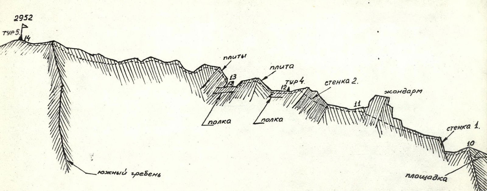
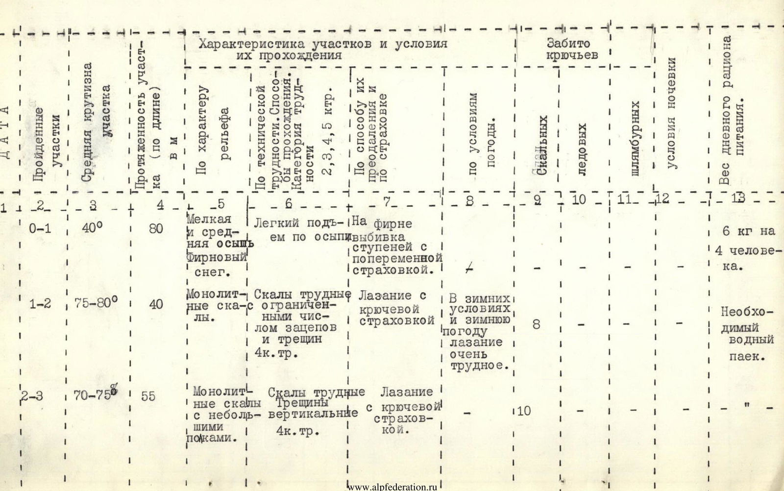
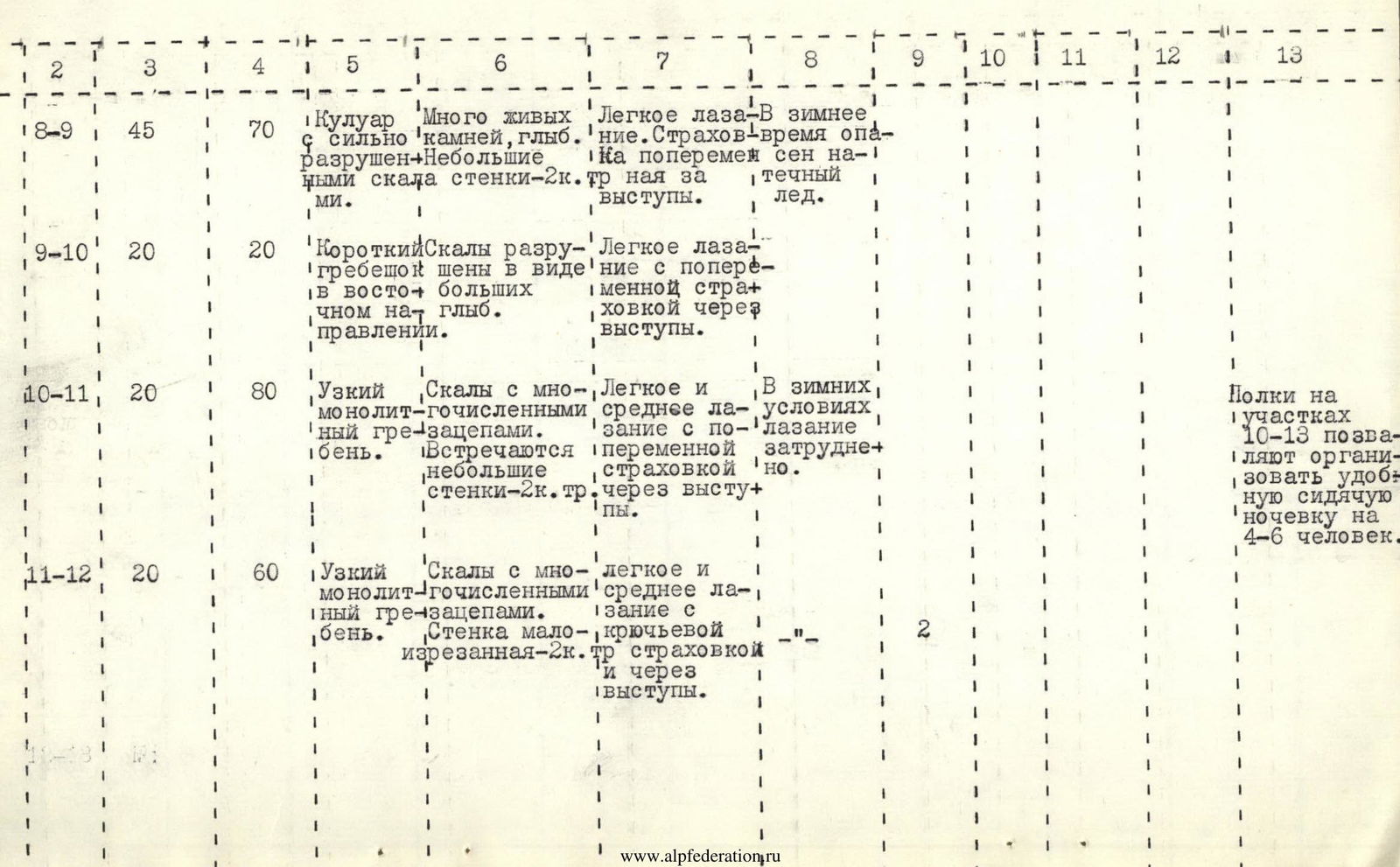
| № | Steepness of section | Length of section (along length), m | Character of relief | By technical difficulty (category of difficulty) | By method of overcoming and belay | By weather conditions | Number of pitons (rock) | Number of pitons (ice) | Number of pitons (drill) | Overnight stay conditions | Weight of daily ration |
|---|---|---|---|---|---|---|---|---|---|---|---|
| R0–R1 | 40° | 80 | Small and medium scree. Firn snow. | Easy ascent along scree | On firn - step cutting with alternating belay. | ||||||
| R1–R2 | 75–80° | 40 | Monolithic rocks. | Difficult rocks, limited holds and cracks 4 cat. diff. | Climbing with piton belay. | In winter conditions and weather - very difficult climbing. | 8 | Necessary water ration. | |||
| R2–R3 | 70–75° | 55 | Monolithic rocks with small ledges. | Difficult rocks. Vertical cracks 4 cat. diff. | Climbing with piton belay. | 10 |

| № | Steepness of section | Length of section (along length), m | Character of relief | By technical difficulty (category of difficulty) | By method of overcoming and belay | By weather conditions | Number of pitons (rock) | Number of pitons (ice) | Number of pitons (drill) | Overnight stay conditions | Weight of daily ration |
|---|---|---|---|---|---|---|---|---|---|---|---|
| R3–R4 | 70–75° | 40 | Monolithic rocks. "Mirror" in the middle part 15 m. | Very difficult rocks. Rocks – 5 cat. diff. | Climbing with piton belay. | 6 | |||||
| R4–R5 | 75–80° | 35 | Rocks monolithic with limited holds, no ledges. | Very difficult rocks – 5 cat. diff. | Climbing with piton belay. | 7 | |||||
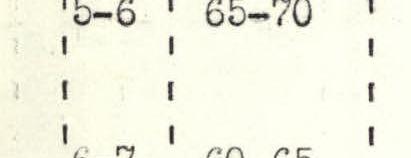
| R5–R6 | 65–70° | 30 | Rocks monolithic. | Difficult rocks – 4 cat. diff. | Climbing with piton belay. | 7 | |||||
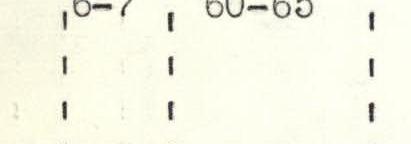
| R6–R7 | 60–65° | 30 | Rocks monolithic with small ledges. Upper section 6 m very difficult rocks – 5 cat. diff. | Rocks of medium difficulty – 3 cat. diff. | Climbing with piton belay. | 5 | |||||
| R7–R8 | 70–75° | 40 | Inner corner strongly fragmented. At the top - a "plug". | Rocks of medium difficulty with sheer sections – 3 cat. diff. and for outcrops. Prone to rockfall during rain. | Climbing with piton belay. Lower 10 m - horizontal perlon rope. | In winter, prone to black ice. | 4 |
| № | Steepness of section | Length of section (along length), m | Character of relief | By technical difficulty (category of difficulty) | By method of overcoming and belay | By weather conditions | Number of pitons (rock) | Number of pitons (ice) | Number of pitons (drill) | Overnight stay conditions | Weight of daily ration |
|---|---|---|---|---|---|---|---|---|---|---|---|
| R8–R9 | 45° | 70 | Couloir with strongly destroyed rocks. Many loose stones, blocks. Small walls – 2 cat. diff. | Easy climbing. Alternating belay for outcrops. | In winter, prone to black ice. | ||||||
| R9–R10 | 20° | 20 | Short ridge in easterly direction. Rocks destroyed in the form of large blocks. | Easy climbing with alternating belay for outcrops. | |||||||
| R10–R11 | 20° | 80 | Narrow monolithic ridge. Rocks with numerous holds. Small walls – 2 cat. diff. | Easy and medium climbing with alternating belay for outcrops. | In winter conditions, climbing is difficult. | Ledges on sections R10–R13 allow for convenient sitting overnight stay for 4–6 people. | |||||
| R11–R12 | 20° | 60 | Narrow monolithic ridge. Rocks with numerous holds. Wall slightly fragmented – 2 cat. diff. | Easy and medium climbing with piton belay and for outcrops. | 2 |
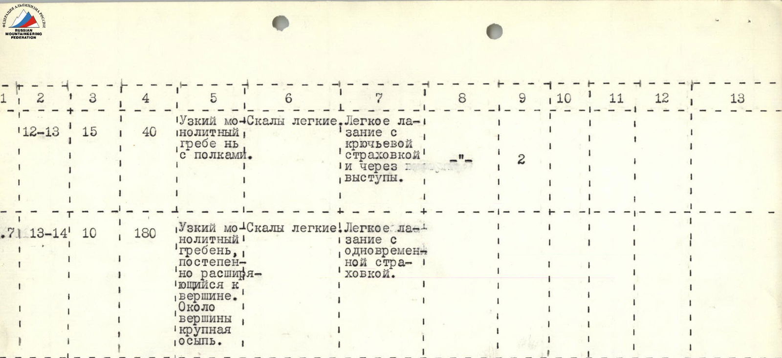
| № | Steepness of section | Length of section (along length), m | Character of relief | By technical difficulty (category of difficulty) | By method of overcoming and belay | By weather conditions | Number of pitons (rock) | Number of pitons (ice) | Number of pitons (drill) | Overnight stay conditions | Weight of daily ration |
|---|---|---|---|---|---|---|---|---|---|---|---|
| R12–R13 | 15° | 40 | Narrow monolithic ridge with ledges. Easy rocks. | Easy climbing with piton belay and for outcrops. | |||||||
| R13–R14 | 10° | 180 | Narrow monolithic ridge, gradually widening towards the summit. Near the summit - coarse scree. Easy rocks. | Easy climbing with simultaneous belay. |
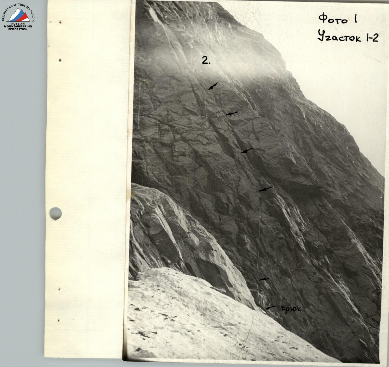
Photo 2 Section R2–R3
Comments
Sign in to leave a comment