Brief Geographical Description of the Area
The peak Moygota is located in the main ridge of the Tunkinskie Goltsy mountain range in the Eastern Sayan Mountains. Tunkinskie Goltsy is the highest ridge in the Eastern Sayan Mountains, stretching 200 km in a latitudinal direction. The highest point of the ridge reaches 3266 m above sea level in the upper reaches of the Ganga-Kharym gorge.
Overall, the ridge has sharp alpine forms with deep gorges and wide glacial cirques. For over 100 km - from the Arshan resort in the east to the Shumak pass in the west - the ridge has many peaks of great interest to climbers.
- The forest boundary on the southern slopes is at 1800 m, and on the northern slopes at 1600–1700 m.
- The snow cover almost completely melts by the end of summer.
- Glaciation is found only in the western part of the ridge.
Moygota peak has an elevation of about 2883 m above sea level. The nearest settlements - Arshan and Tagarhay - are 25–30 km away. Access is via a dirt road to the Moygota gorge, then a 4-hour ascent up the gorge to the base camp at the forest boundary.
From the base camp at the forest boundary:
- 2 hours up the gorge to the first lake at the fork in the gorge.
- The ridge dividing the upper reaches of the gorge is the southern ridge to Mt. Moygota.
- Bypassed the lake on the right and approached the start of the ridge via large rocks.
Section 0–1
Snow-covered rocks and large isolated boulders. Climbing with simultaneous belay, 4 ropes. Reached the start of the couloir leading to the ridge.
The couloir is 45° steep, 2 ropes. Belay is alternate at times. (photo 1). Then along the ridge to the right, 2 ropes. Here is the first cairn. (photo 2).
Section 1–2
Very large boulders with deep holes between them. Climbing with alternate belay, 3 ropes (photo 3) to the gendarme (photo 2).
Section 2–3
1 rope - ascent to the gendarme directly and then bypassing to the right with a descent into an internal angle and further to the right down a cleft to a small platform. Here is the belay point.
Further:
- 2 ropes - traverse with a slight ascent (photos 5 and 6).
- After that, there is a wall of half a rope to a slab with a slit (photos 7 and 8).
The slab can be bypassed on both the right and left, but the group does not recommend it - loose rocks.
Reached the ridge directly via the slab, using the slit and small holds (photos 9, 10, and 11). Belay is alternate throughout, using pitons and occasional protrusions. Here is the second cairn.
Section 3–4
From the cairn, a sharp ridge leads to the second gendarme (photo 12). The gendarme is bypassed on the right.
- 1 rope - traverse (photo 14).
- Then half a rope - a wall and overcoming a buttress.
- Above, there is a pile of loose rocks; be cautious!
- Then 3 m - descent from the buttress and 1 rope - a wide chimney leading to the ridge.
- Belay is alternate using pitons.
The top of the gendarme is left behind, but there is still a descent via a double rope (photo 13), 1x40 m is sufficient for the descent. The descent can be done in a sporting manner.
The saddle is a good spot for a bivouac or lunch. In the middle of the day, it's quite warm and quiet here.
Section 4–5
The section represents a fairly straightforward path - to the left of the ridge to the third gendarme. Belay is simultaneous.
Section 5–6
Ascent to the gendarme - rocks of medium difficulty, 1 rope (photo 15).
Further:
- 5 m - a small drop (photo 17);
- a ridge intersected by crevices (photo 18).
Belay is alternate until a section with a very narrow ridge and a shelf on the left (photo 19).
Section 6–7
Descent from the ridge to the left via a double rope 2x20 m to a shelf and along the shelf, bypassing the monolithic ridge (photo 20). It is possible to proceed directly along the ridge with petal pitons. There is very little choice of cracks, making it impossible to organize belay. After the shelf - a saddle and the fourth gendarme.
Section R7–R8
The gendarme is bypassed on the left with a descent, 1 rope for descent, and then ascent via slabs (photos 21, 22, and 23). Exit to the scree shoulder of the gendarme and to the left via large rocks to the ridge. Belay is initially alternate and finally simultaneous.
Section R8–R9
Large rocks and medium scree on the ridge, simultaneous belay, 5–6 ropes.
Here, before starting the ascent to the sub-summit, is the third cairn.
Section 9–10
The sub-summit is bypassed on the left. From the cairn, a traverse along scree and slabs to an edge leading to the summit. Initially, the edge consists of monolithic rocks of medium difficulty, 2–3 ropes (photos 24, 25). Belay is alternate, and in the upper part, there are loose rocks. Bypassed on the left as one proceeds. Further, a wide couloir with large scree leads to the summit (photo 26). Descent along the Eastern slope, 1 km.
Group Composition
- Mikhailov A. - 2nd category. 4A
- Petrushin Yu. - 1st category. 4A, 4A, 4B, 4B, 4B, 5A, 5A.
- Mikhailova R. - 2nd category. 4A, 4A, 4A.
- Gornushenkova S. - 3rd category. 3B, 3B, 3A, 3A, 3A. The group assessed the route as 3.5 km.
Table
of the main characteristics of the route. The ascent route is the Southern ridge to Mt. Moygota. The height difference of the route is 650–700 m. Including the most difficult sections - 50–100 m. Steepness of the route - 20°.
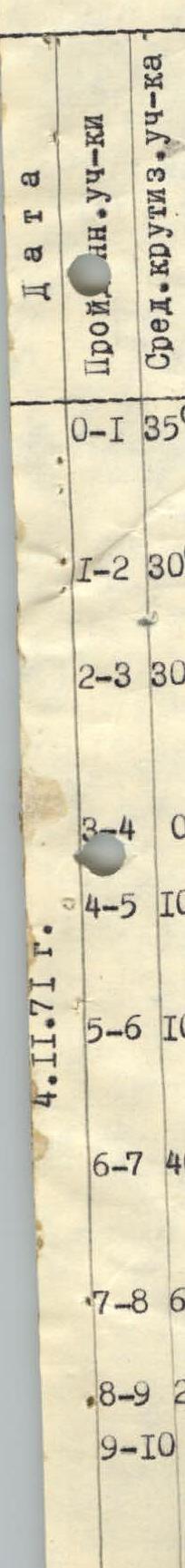 |  |  |  |  |  | Time | Weather | Pitons driven, rock | ice |
|---|---|---|---|---|---|---|---|---|---|
| Section 0–1 | 35° | 300 m | Snow-covered rocks | Free climbing 2A | Simultaneous, alternate, protrusions | Sunny, calm, frosty | 0 | 0 | |
| Section 1–2 | 30° | 120 m | Large snow-covered boulders | Free climbing 2A | —"— | —"— | 0 | 0 | |
| Section 2–3 | 30° | 100 m | Snow-covered rocks | Free climbing 4A | Alternate, pitons, protrusions | Cold, calm | 5 | 0 | |
| Section 3–4 | 0° | 170 m | Snow-covered rocks | 4A | —"— | —"— | 7 | 0 | |
| Section 4–5 | 10° | 200 m | —"— | Free climbing 2A | Simultaneous, protrusions | Sunny, calm, warm | 10 | 0 | |
| Section 5–6 | 10° | 80 m | Rocky ridge | Free climbing 3B | Alternate, pitons, protrusions | —"— | 4 | 0 | |
| Section 6–7 | 40° | 120 m | Snow-covered rocks | Descent via double rope 3B | Sport descent, pitons, loops | —"— | 3 | 0 | |
| Section 7–8 | 60° | 100 m | —"— | Free climbing 3B | Alternate, pitons, protrusions | Sunny, warm, calm | 5 | 0 | |
| Section 8–9 | 20° | 300 m | —"— | 1B | Simultaneous, protrusions | Warm, calm | 0 | 0 | |
| Section 9–10 | 30° | 700 m | Rocks, snow | Free climbing 3A | Simultaneous, alternate, railings, pitons, protrusions | Frosty, calm | 3 | 0 | |
| Total pitons driven: 12 (rock), 27 (ice). | |||||||||
| Elevation 2200 m. |
Recommendations for Climbers
- Group size not more than 6 people.
- Departure on the route in winter not later than 7:00, in summer not later than 8:00.
- Descent is possible - from the third cairn to the left, into the western cirque.
Equipment for a group of 4 people.
- Main rope 1x40 m - 2 pieces.
- Expendable cord - 15 m.
- Rock pitons - 15 pieces.
- Rock pitons (petal) - 5 pieces.
- Hammers.
Group leader Mikhailov
Chairman of the Classification Commission Shishkin
 36 cat. tr. No. 10 dated November 6, 1972.

Photo 17
Photo 25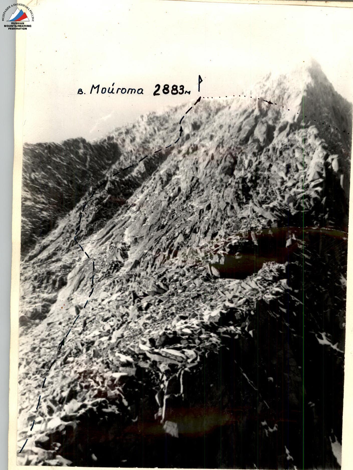
Photo 26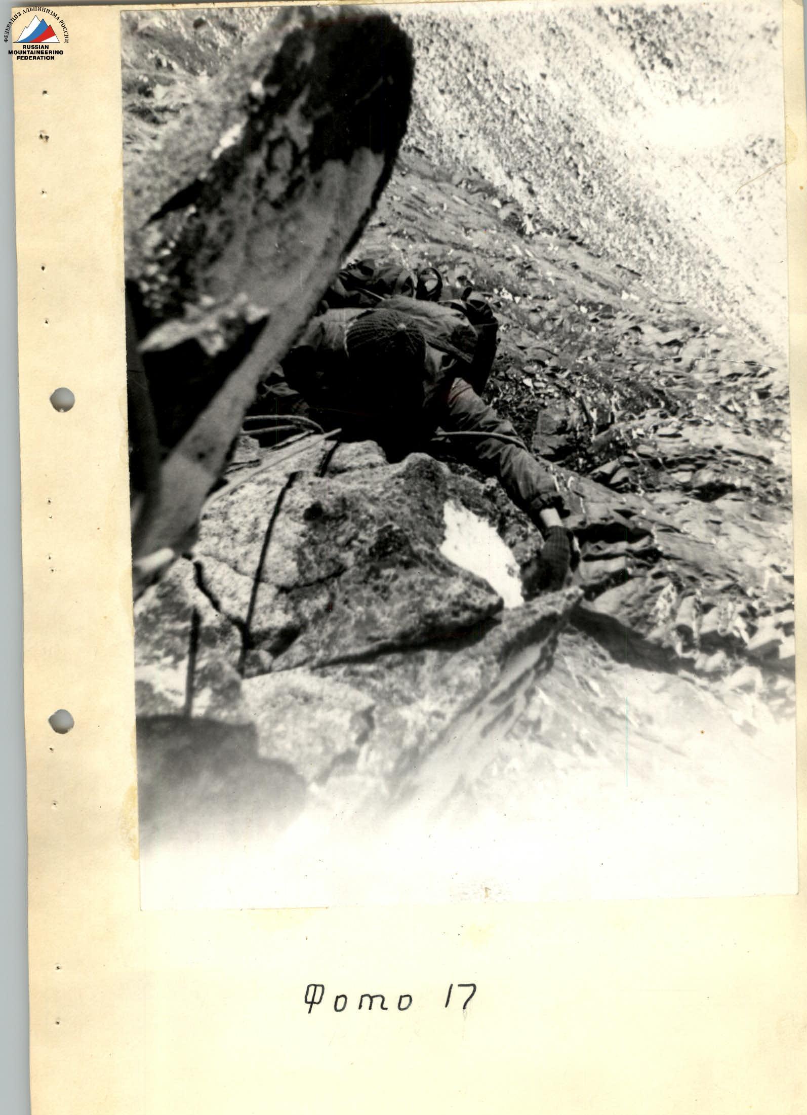
Photo 18
www.alpfederation.ru