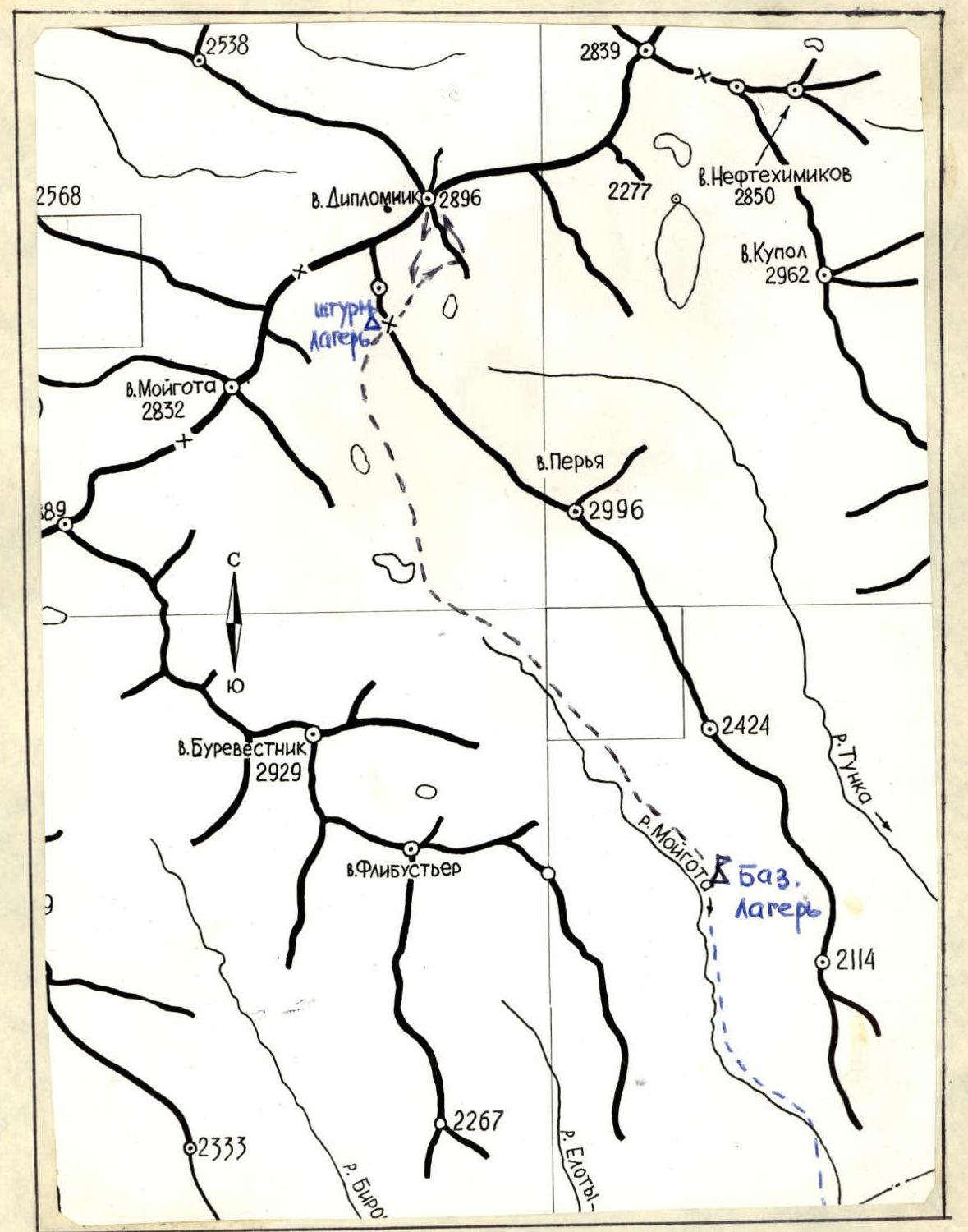
Climbing Area Map
Geographic Location, Climate, and Sporting Characteristics of the Area
Administratively, the area belongs to the Buryat ASSR. The Diplomnnik peak closes the northwestern cirque of the Tunka River valley and is located in the main watershed ridge of the Tunkinsky Goltsy range in the Eastern Sayan Mountains. The relief of the area is alpine, rugged, with peaks characterized by numerous destroyed counterforts, bizarre granite "towers," and "knives" having a monolithic block structure. The absolute heights of the peaks are around 3000 m, with Diplomnnik peak being 2896 m.
The snow cover begins to form in August and September on the leeward slopes, reaching a depth of 2 m, and almost completely melts only by the end of May or June.
Weather characteristics:
- During the establishment of winter conditions (in October and November), the weather is unstable, with snowstorms and frequent, sharp cold snaps (sometimes up to 35°).
- Winter weather conditions are stable and sunny.
- The sharply continental climate causes significant temperature fluctuations: at night, temperatures average -30°C, sometimes dropping to -45°C, while during the day, they average -20°C to -25°C, sometimes dropping to -40°C.
- In mountain cirques, it is 5–10 degrees warmer.
- Spring is characterized by unstable weather, with frequent snowstorms and gusty winds.
There is no glaciation in the area. Currently, 6 routes of 1B–3B difficulty categories are classified in the Moygota valley.
Table of Main Characteristics of the Ascent Route to Diplomnnik Peak

| Date | Designation | Average Steepness (degrees) | Length in meters | Character of Relief | Difficulty Category | Condition | Weather Conditions | Pitons |
|---|---|---|---|---|---|---|---|---|
| November 5, 1978 | R0–R1 | 35 | 350 | Talus; Wall — 10 m. | 1 | Rocky, average | Occasional light snowstorm | Not hammered, belay through outcrops |
| R1–R2 | 25 | 160 | Wide ridge; Slope | 1 | Monolithic and broken slope; Snowy slope | |||
| R2–R3 | 45 | 130 | Slope | 1–2 | Snowy monolithic slope | |||
| R3–R4 | 25 | 120 | Ridge (sporting descent – 7 m.) | 1–2 | Broken slope | |||
| R4–R5 | 45 | 90 | Ridge with small walls | 1–2 | Broken slope; Monolithic outcrops | |||
| R5–R6 | 15 | 140 | Wide ridge | – | Snow, talus | |||
| R6–R7 | 30 | 70 | Ridge | 1 | Broken slope |
Description of the Approach to the Route and Brief Explanation of the Table
From Arshan settlement, through Tagarkhay village, westward along the Tunkinsky Goltsy ridge, via a forest road — approximately 23 km (to the loggers' barrack).
Further:
- Northward to the narrow entrance to the Moygota valley — about 4 km;
- Bypassing the canyon part of the valley on the left (orographic) side — to the base camp, near the forest boundary — approximately 7–8 km.
There is no trail. The approach from the road to the camp with an average load takes a winter daylight day.
The approach to the route goes from the base camp (overcoming three tiers of ridges):
- To the lake under the end of the southern ridge of Moygota peak — 2.5 hours;
- Further to the pass leading to the Tunna valley — 1 hour.
On the pass is the assault camp. Descent with a traverse to the left into a hanging valley and, turning rightward along the way, cross it.
Climb up a wide couloir in the lower part. In the upper third of the couloir, there is a narrowing — easy climbing for 10 m (section R0–R1). Exit onto the ridge. The route goes along the ridge with a subsequent traverse to the right, bypassing the ridge's monolithic towers (section R1–R2). Ascent along snowy large-block rocks onto the ridge (section R2–R3). Movement along the rugged ridge (section R3–R4), then along its steep part with easy climbing (section R4–R5). Exit onto a wide, gently sloping pre-summit shoulder. Along it — to the summit (section R5–R6). A small ascent on the ridge (section R6–R7). Summit. From the pass — 4 hours of climbing.
Descent:
- Initially, along the ascent path, to the point of exit onto the pre-summit shoulder, from there sharply to the right downward, via a narrow couloir. The couloir is clearly visible when approaching the route.
- The second descent option — from the same shoulder — along the easy rocks of the western ridge.
Descent took 40 minutes. Ascent to the pass — 50 minutes.
The route is characterized by a diverse set of несложные несложных rock sections and requires participants to act clearly, both in choosing the route and in organizing simultaneous and alternate belaying through outcrops.
The group believes that the route corresponds to 2A difficulty category.
For a trained training group, it is possible to complete the ascent from the base camp (in the Moygota valley) and back within 10–12 hours.

