ASCENT DOCUMENT
- Class — rock climbing.
- Area — Eastern Sayan, Tunkin Goltsy ridge, Kyngarga valley.
- Peak, its height, and ascent route: p. Devyatoe maya, 2578 m, between the "diamonds" on the NE slope.
- Proposed category of difficulty: 2B.
- Route characteristics:
- height difference — 500 m.
- route length — 1100 m.
- average steepness — 40°.
- Pitons hammered: rock — 4 pcs.
- Number of travel hours — 6 hours.
- No overnight stays on the route.
- Third ascent of the route: leader Khandazhapov B. A. — Master of Sports, Voilichshenko S. K., Mikhalev P. A., Sazonov R. A., Gutentog A. M., Zherdev V. A., Trufanova T. N., Markov D. V.
- Team coach: Afanasyev A. E. — Master of Sports.
- Exit to the route and return: May 6, 2003.
Second ascent: leader Afanasyev A. E. — Master of Sports, Neytan Yu. E. — 1st sports category, Kartsev S. — 3rd sports category, Chuprov A. — 3rd sports category, Shudegova S. — 3rd sports category. November 8, 1989.
First ascent: leader Nikonov V. P. — 2nd sports category, Naryshkin G. A. — 2nd sports category, Khusnutdinov A. M. — 1st sports category, Metelitsa M. M. — 2nd sports category. May 2–3, 1970.
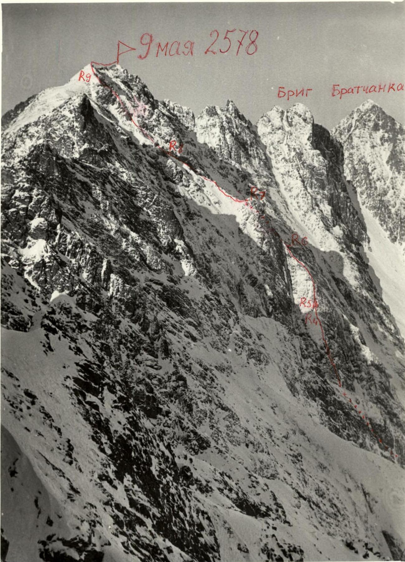
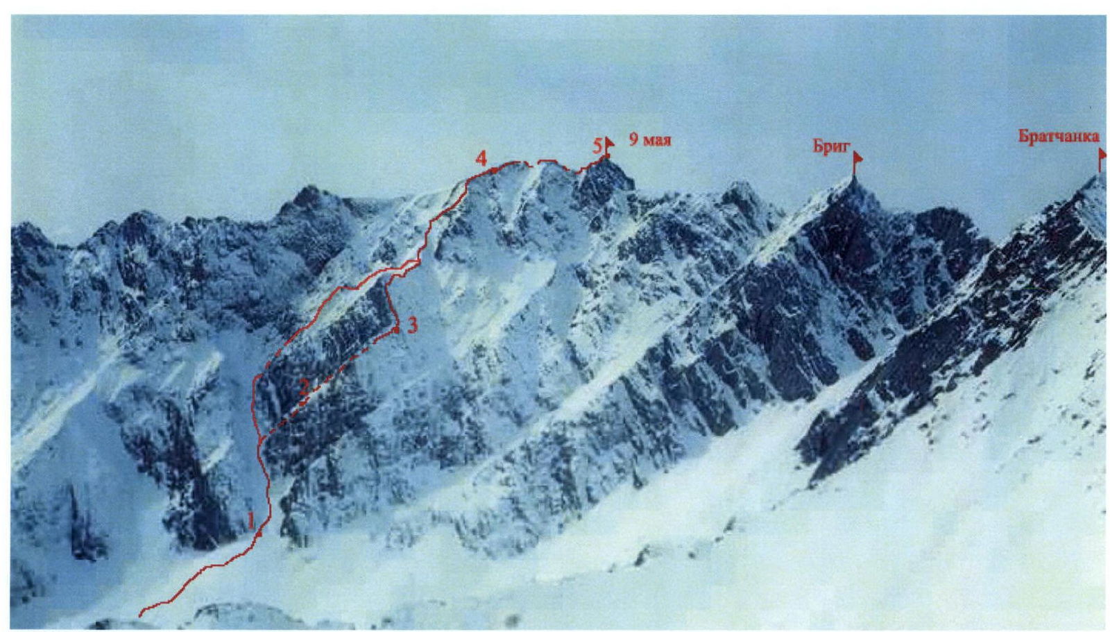
Photo of the route on p. 9 maya via the NE slope. 2B category of difficulty.
ROUTE DESCRIPTION
ascent to p. 9 maya 2579 m, between the "diamonds" on the NE slope
The mountain 9 maya is located in the cirque of p. Bratchanka in the valley of the Pravaya Kyngarga River, Tunkin Goltsy ridge, Eastern Sayan, and is the dominant height in this valley. Among the classified routes, only one passes through the summit — the traverse Brig — 9 maya — Trekhglavaya (C), 4A category of difficulty. This route is quite long for this valley and can be easily identified visually. The approach takes 40 minutes from the "Nadezhda" winter hut. The route begins in a couloir to the left of the "diamonds".
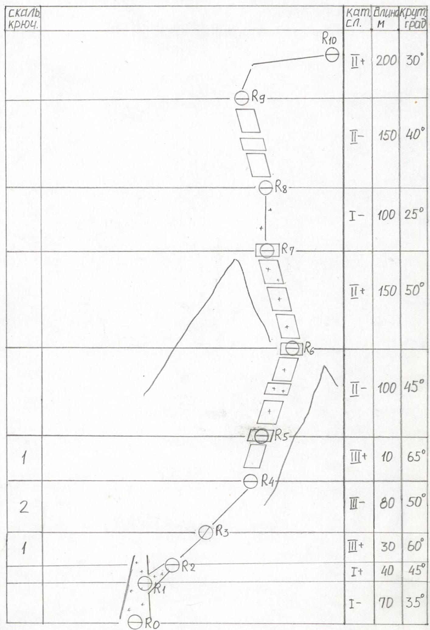
| Section | Length | Steepness | Category | Section characteristics |
|---|---|---|---|---|
| R0–R1 | 70 m | 35° | 1 | Couloir with snow. |
| R1–R2 | 40 m | 45° | 1 | Up steep snow on the left side into the couloir separating the diamonds. |
| R2–R3 | 30 m | 60° | 3 | Up and right onto the ridge of the lower diamond. |
| R3–R4 | 80 m | 50° | 3 | Rocky ridge. |
| R4–R5 | 10 m | 65° | 3 | Rocky wall. |
| R5–R6 | 100 m | 45° | 2 | The ridge turns into snow-covered slabs and shelves. Exit to the summit of the lower diamond. |
| R6–R7 | 150 m | 50° | 2 | Along the right edge of the upper diamond. Snow-covered rocks. |
| R7–R8 | 100 m | 25° | 1 | Snow ridge from the summit of the upper diamond. |
| R8–R9 | 150 m | 40° | 2 | Rocks and talus. |
| R9–R10 | 200 m | 30° | 2 | Traverse the ridge through a false summit to the peak 9 maya. |
Descent follows the ascent route to the summit of the second diamond. Then descend via the couloir (25°) to the right. Exit to the right edge, which ends in a drop into a large couloir where the ascent began. Ropes (60°) for 50 m to the right of the edge into the large couloir. Descend via the couloir into the cirque under the summit.
UIAA SCHEME
| Rock pitons | Section | Category of difficulty | Length, m | Steepness, ° |
|---|---|---|---|---|
| R10 | 2 | 200 | 30 | |
| R9 | 2 | 150 | 40 | |
| R8 | 1 | 100 | 25 | |
| R7 | 2 | 150 | 50 | |
| R6 | 2 | 100 | 45 | |
| 1 | R5 | 3 | 10 | 65 |
| 2 | R4 | 3 | 80 | 50 |
| 1 | R3 | 3 | 30 | 60 |
| R2 | 1 | 40 | 45 | |
| R1 | 1 | 70 | 35 | |
| R0 |
Scale 1:3000