Report
ON THE FIRST ASCENT OF MT. DAL'NYAYA 3063 m, VIA THE SOUTHEAST RIDGE SPUR, APPROXIMATELY CATEGORY 2A DIFFICULTY, FROM OCTOBER 20, 2018 TO OCTOBER 20, 2018. Irkutsk 2018
I. Ascent Passport
| 1. General Information | ||
|---|---|---|
| 1.1 | Full Name, Sports Rank of the Leader | Glazunov Evgeny Vladimirovich (Master of Sports) |
| 1.2 | Full Name, Sports Rank of Participants | Kozyreva Alena Timofeevna (novice) Badryzlova Ksenia Sergeevna (novice) Lavellina Natalia Vladimirovna (novice) Donicheva Nadezhda Sergeevna (novice) Kalashnikov Andrey Yuryevich (novice) |
| 1.3 | Full Name of Coach | Glazunov Evgeny Vladimirovich (Master of Sports) |
| 1.4 | Organization | Irkutsk Regional Public Organization Club of Active Leisure and Alpinism "Gory Baikal'a" |
| 2. Characteristics of the Climbing Object | ||
| 2.1 | Region | Eastern Sayan, Tunkinskie Gol'tsy Ridge |
| 2.2 | Valley | Shunten-Gorkhon |
| 2.3 | Section Number According to the 2013 Classification Table | 6.1.2 |
| 2.4 | Name and Height of the Summit | Dal'nyaya, 3063 m |
| 2.5 | Geographical Coordinates of the Summit (latitude/longitude), GPS Coordinates | 51°50′47.972″ N 101°33′54.410″ E |
| 3. Characteristics of the Route | ||
| 3.1 | Name of the Route | Southeastern Ridge Spur |
| 3.2 | Proposed Category of Difficulty | 2A |
| 3.2.3 | Degree of Route Exploration | First Ascent |
| 3.4 | Nature of the Route Terrain | Rocky |
| 3.5 | Elevation Gain of the Route (data from altimeter or GPS) | 463 m |
| 3.6 | Length of the Route (in meters) | 500 m |
| 3.7 | Technical Elements of the Route (total length of sections with various difficulty categories, indicating the nature of the terrain (ice-snow, rocky)) | Category I difficulty ice/rock/combination – 50 m. Category III difficulty ice/rock/combination – 100 m. Category II difficulty ice/rock/combination – 150 m. Category III difficulty ice/rock/combination – 200 m. |
| 3.8 | Descent from the Summit | Along the ridge 100 m in the northern direction, descent via scree gully 500 m in the southeast direction from the saddle between two summits into the Shunten-Gorkhon river valley |
| 3.9 | Additional Characteristics of the Route | Lack of water |
| 4. Characteristics of Team Actions | ||
| 4.1 | Time in Motion (team's walking hours) | 3:00 h |
| 4.2 | Overnight Stays | No |
| 4.3 | Time at Control Points | Departure from Shunten-Gorkhon Base Camp – 6:00, start at R0 – 7:00, summit – 10:00, descent to the saddle between summits to the descent gully – 10:10, descent to the valley – 11:00, return to Shunten-Gorkhon Base Camp – 11:30, return to Chertolen-Gorkhon Base Camp – 16:00 |
| 5. Characteristics of Weather Conditions | ||
| 5.1 | Fog, poor visibility, no precipitation, moderate south wind, temperature around 10 °C. | |
| 6. Person Responsible for the Report | ||
| 6.1 | Full Name, e-mail | Donicheva Nadezhda Sergeevna Nadezhda-geo@inbox.ru |
II. Description of the Ascent
1. Characteristics of the Climbing Object
Mt. Dal'nyaya is located in the upper reaches of the Shuntyng-Gorkhon valley, Tunkin Ridge, Eastern Sayan, west of the Chertolen-Gorkhon and Khubuta river valleys.
A trail leads along the Khubuta river valley to the Shumak mineral springs, a popular tourist route in our region.
Nearest settlements:
- Nilova Pustyn settlement
- Khoyto-Gol village, Tunkinsky district, Republic of Buryatia (district center – Kyren settlement).
Access to the main base camp in Chertolen-Gorkhon is via an old dirt road to the "Sukhoy Ruchey" tourist base, then:
- by high-clearance vehicle along the dirt road,
- on foot to the Chertolen-Gorkhon river.
A good trail leads into the valley.
Access to the upper Shuntyng-Gorkhon valley is by foot via the Chertolen-Gorkhon valley and then over the pass between the Shkol'naya and Optimist peaks.
The valley is a dead end and is visited by local herb and wild food gatherers. Horses can be used for transportation along the trail.
The Shuntyng-Gorkhon valley is unexplored for alpinism, and routes have not been classified or visited by tourists. Only the first ascent in the Chertolen-Gorkhon valley to the "Optimist" peak via a 2A–2B category route (led by Nikonov V.P.) and the ascent to the "Obmanchivaya" peak via a 5A category route (led by Glazunov E.V.) are known. The reconnaissance conducted allows us to assess the potential of the valley for alpine events with ascents ranging from 1B to 5A category. All ascents will be first ascents.
The chosen peak is characterized by two separate summits. The summit lacks signs of human presence, giving us the right to claim a first ascent. The chosen route is the most logical, with good terrain features. The approach to the route from the base camp takes 1 hour.
The route consists mainly of:
- scree
- standing rocky sections of the ridge
The route is traversed in rope teams, with elements of free climbing on rocky sections.
The team estimates that the route corresponds to similar 2A category routes in the Eastern Sayans.
1.1 Map – Scheme of the Chertolen-Gorkhon and Shuntyng-Gorkhon Valleys
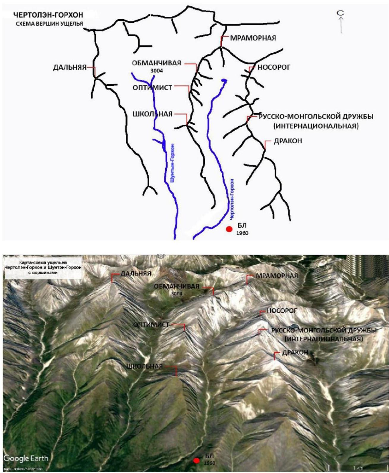
Photo 1. Map – Scheme of the valley
1.2 Map of the Shuntyng-Gorkhon Valley and Approach Route from the Base Camp in the Chertolen-Gorkhon Valley

Photo 2.
1.3 Panoramic View of Mt. Dal'nyaya and Route (photo taken from the Shuntyng-Gorkhon river valley)
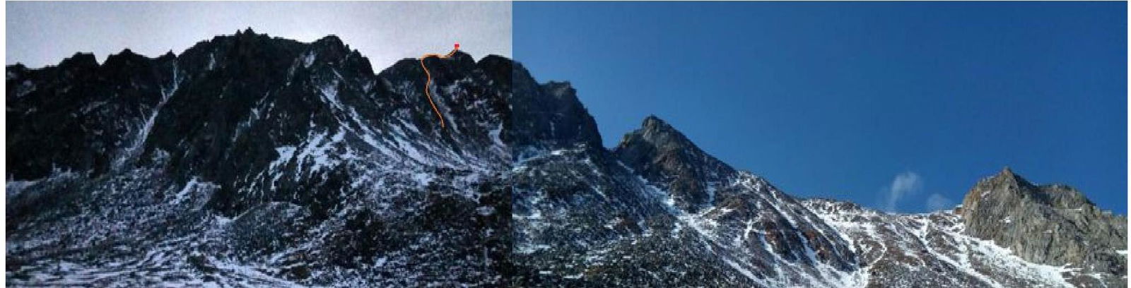
Photo 3.
1.4 Panoramic View of Mt. Dal'nyaya from the Obmanchivaya Peak, Chertolen-Gorkhon Valley
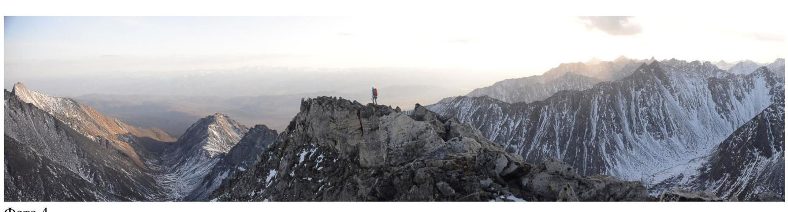
Photo 4.
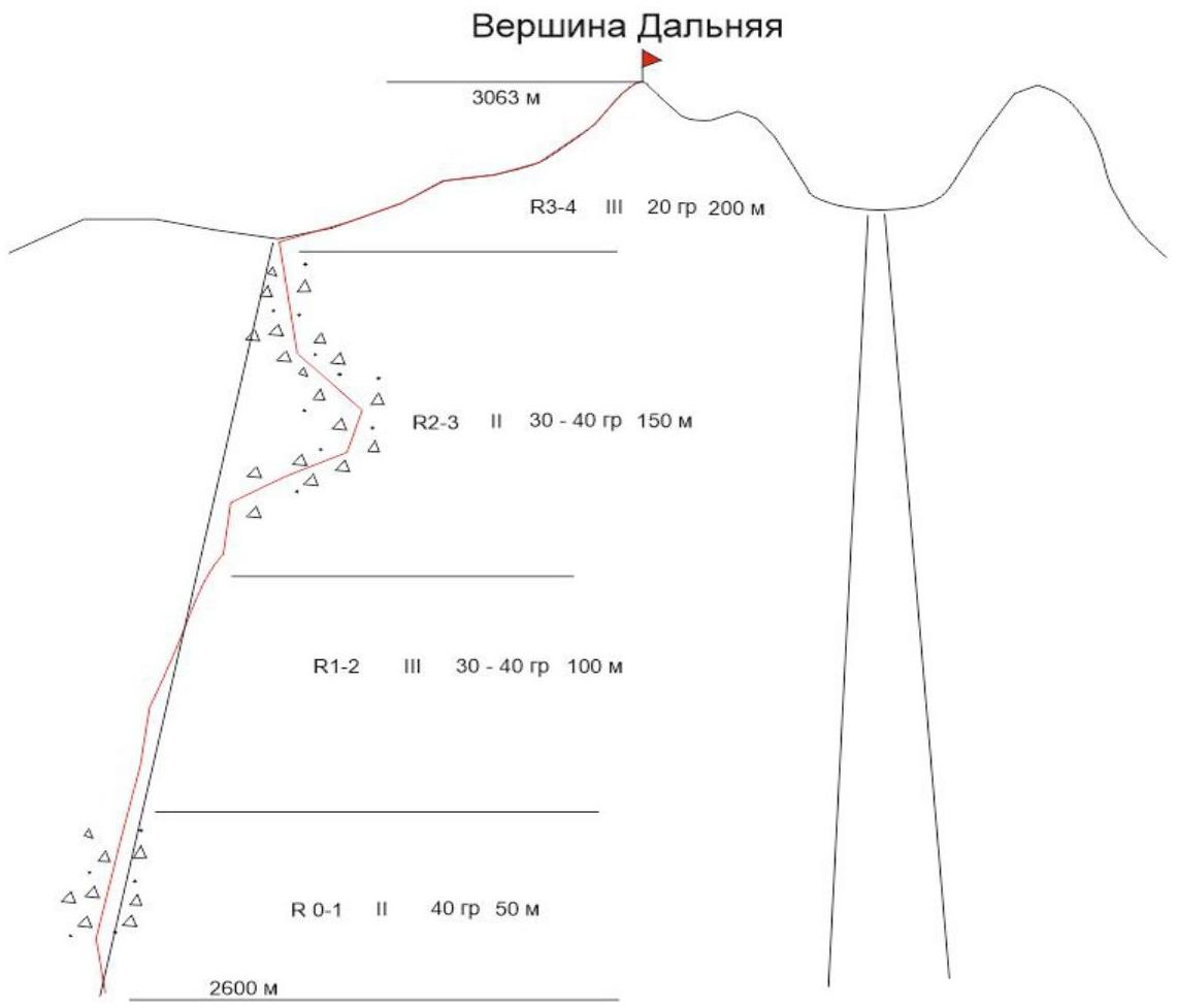
2. Characteristics of the Route
2.1 Technical Photograph of the Route.
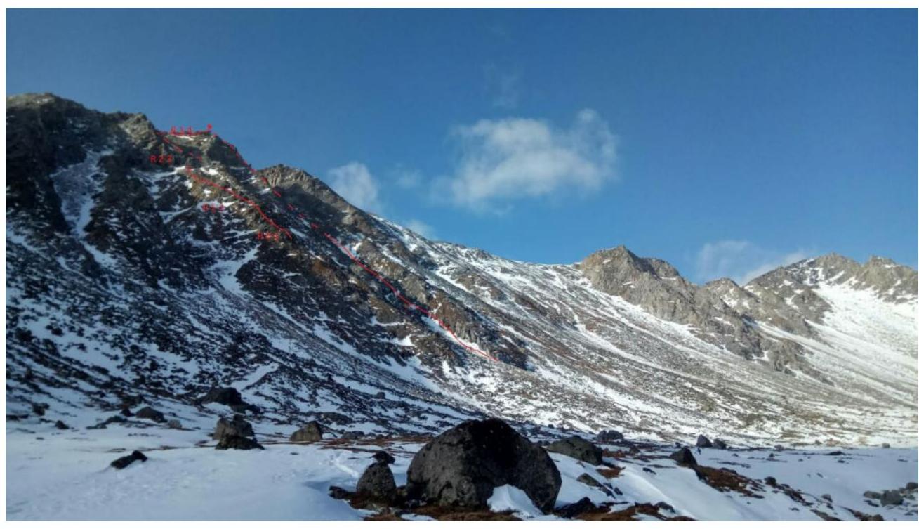
Photo 5.
2.2 Numbers on the Technical Photograph Correspond to Section Numbers on the Route Diagram in UIAA Symbols.
2.3 Route Diagram in UIAA Symbols.
3. Characteristics of Team Actions.
3.1 The approach from the Shuntyng-Gorkhon base camp to the start of the route takes 1 hour. The team follows the trail upstream along the right bank of the river. From the river, they ascend the scree slope towards the southeastern ridge of Mt. Dal'nyaya.
| Section | Description | Photo Number |
|---|---|---|
| R0–R1 | Across the scree, partly grassy slope to a distinct rocky section. The section is traversed on foot. 50 m 40° II | |
| R1–R2 | Rocky section. The section is traversed on foot, often with free climbing. 100 m 30–40° III | Photo 7 |
| R2–R3 | Across the scree, partly grassy slope (gully), with many loose rocks, to a distinct rocky section at the main pre-summit ridge. The route is traversed to the right of the main ridge. Traversed on foot. 150 m 30–40° II | Photo 8 |
| R3–R4 | Rocky section. Pre-summit ridge. Then north to the summit. Summit. Further, slabs with good crack systems, traversed with free climbing. Belays are set to the left of the "jendarme". The section is traversed on foot, often with free climbing. 200 m 20° III | Photo 8 |
3.2 Photograph of the Team at the Summit with the Control Cairn.
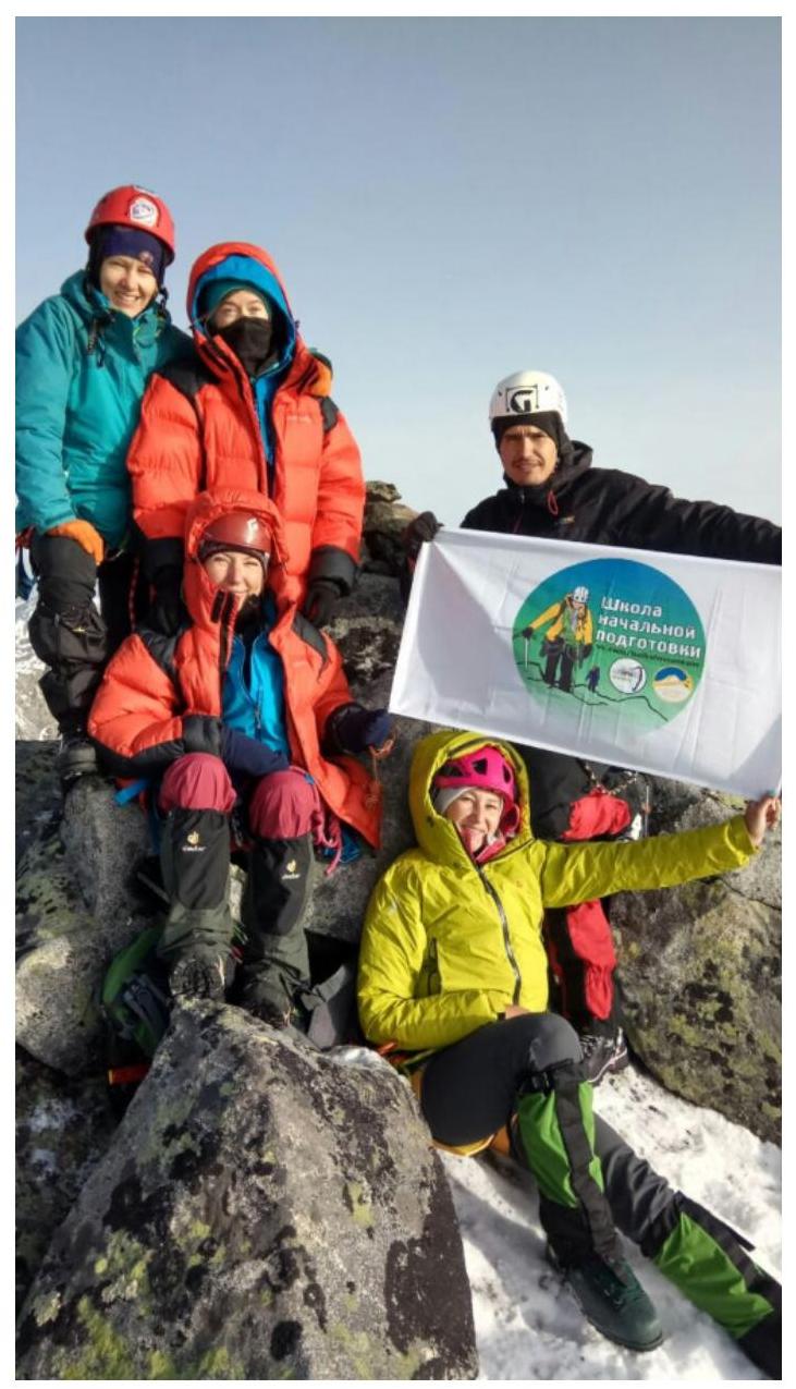
Photo 6.
3.3 Descent from the Summit.
Descent from the summit in a southeast direction from the saddle via a scree gully between the two summits into the Shuntyng-Gorkhon river valley. Return to Base Camp.
The route via the southeastern ridge spur on Mt. Dal'nyaya is assessed by the ascent participants, by analogy with other routes in the Eastern Sayan, to correspond to the 2A category of difficulty.
Photo Report by Sections
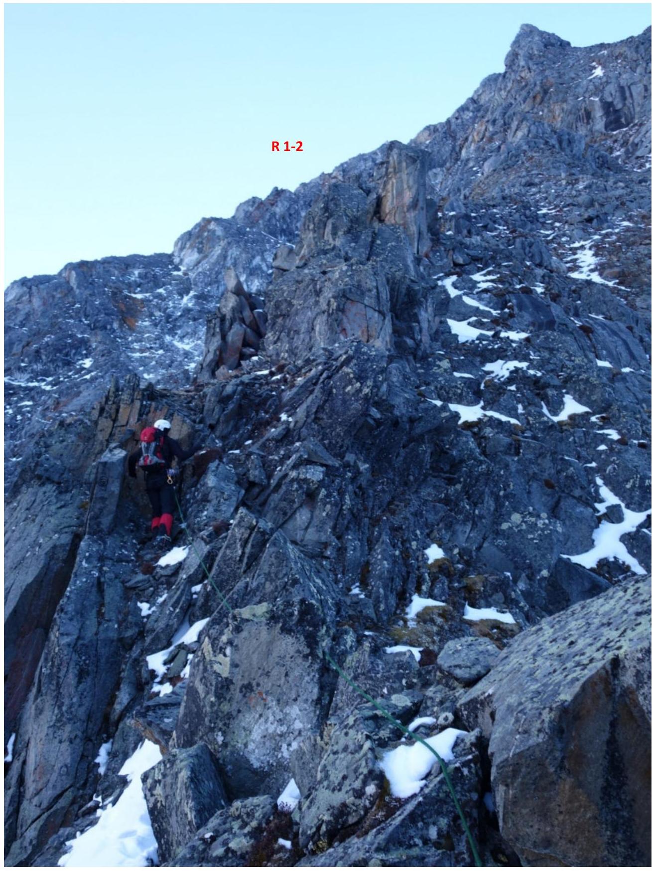
Photo 7. Section R1–R2.

Photo 8. Sections R2–R3 and R3–R4.
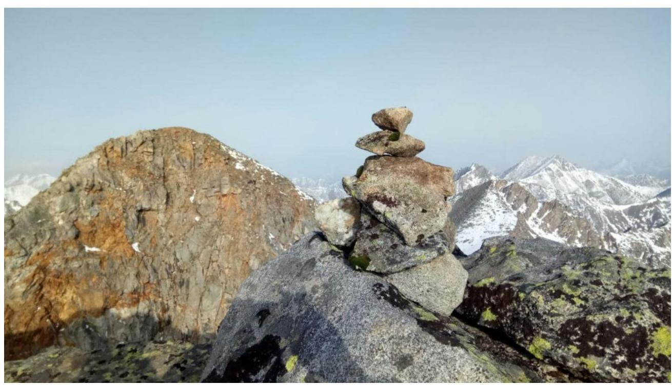
Photo 9. Summit. Control Cairn.
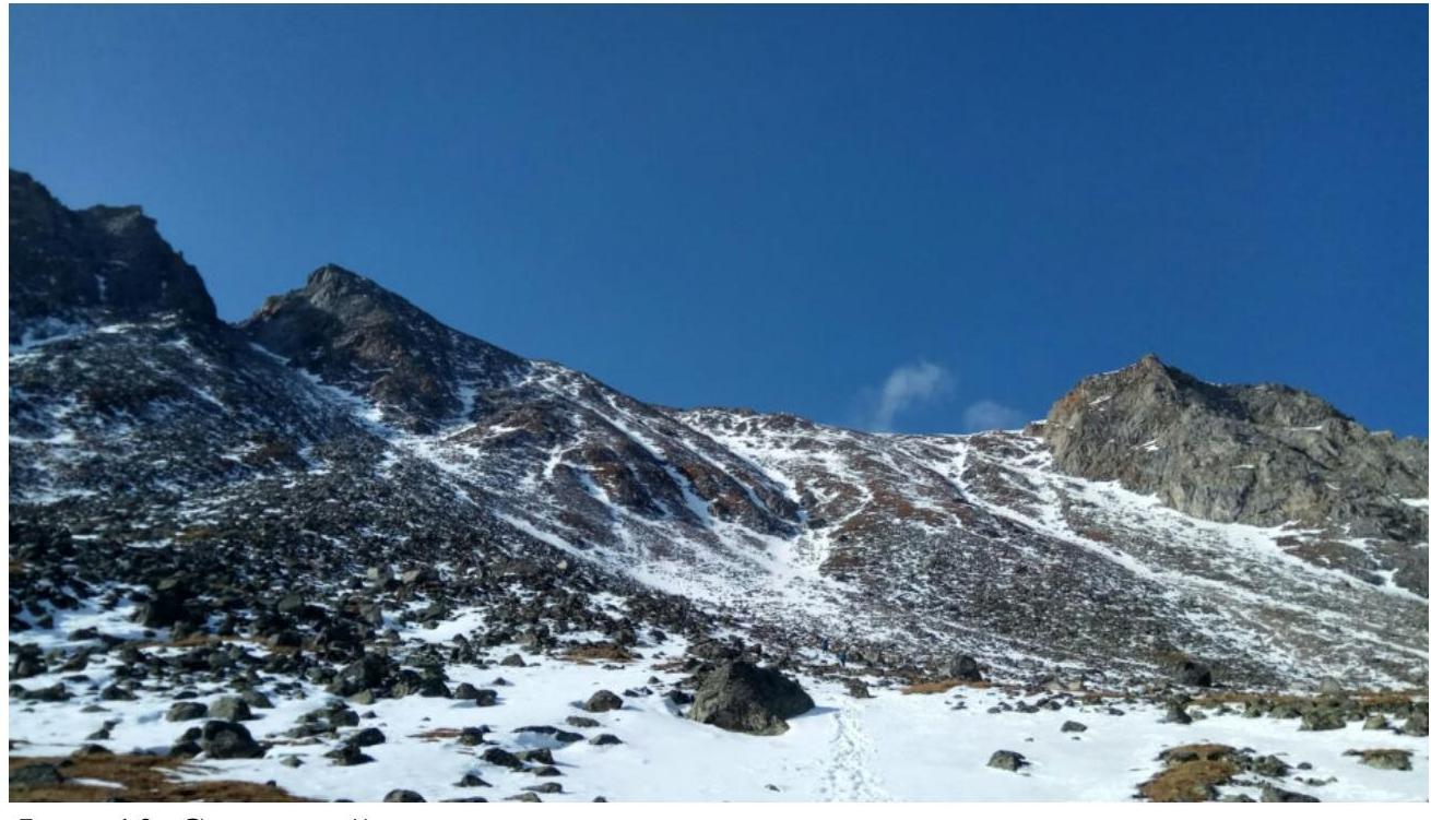
Photo 10. Descent Gully.