Appendix No. 2 to the Unified Requirements for Classification Report
Report Form for Routes 4A–6B Cat. Diff.
Report
On the ascent to the peak Bronenosets via the Central Counterfort of the Western wall route, category 4B, by the team of the Irkutsk Alpine Section, from August 17, 2018.
I. Ascent Passport
| 1. General Information | ||
|---|---|---|
| 1.1 | Full name, sports rank of the team leader | Voylichenko S.K., CMS |
| 1.2 | Full name, sports rank of the participants | Korshunov M.V., 2nd sports rank, Rudman A.P., 2nd sports rank |
| 1.3 | Full name of the coach | Voylichenko Sergey Konstantinovich |
| 1.4 | Organization | Irkutsk Alpine Section |
| 2. Characteristics of the Ascent Object | ||
| 2.1 | Region | Sayans, Tunkinskiye Goltsy |
| 2.2 | Valley | "Dozhdevoye" |
| 2.3 | Section number according to the 2013 Classification Table | 6.1.2. |
| 2.4 | Name and height of the peak | Bronenosets 2430 m (according to the classifier) |
| 2.5 | Geographical coordinates of the peak (latitude/longitude), GPS coordinates *(1) | N51°57.354′ E102°28.525′ |
| 3. Characteristics of the Route | ||
| 3.1 | Route name | Ts kf. Z wall ("Bronya") |
| 3.2 | Proposed category of difficulty | 4B |
| 3.3 | Degree of route development | First ascent – Golovin A.Yu. (2007) |
| 3.4 | Nature of the route terrain | Rock |
| 3.5 | Height difference of the route (altimeter or GPS data) | 240 m |
| 3.6 | Route length (in meters) | 400 m |
| 3.7 | Technical elements of the route (total length of sections of varying difficulty with terrain description) | cat. diff. 1 rock — 130 m. cat. diff. 2 rock — 50 m. cat. diff. 3 rock — 20 m. cat. diff. 4 rock — 20 m. cat. diff. 5 rock — 180 m. cat. diff. 6 rock — М. Rock 6, A3 — М. Rock 6, A4 — М. |
| 3.8 | Average steepness of the route, ° (2) | - |
| 3.9 | Average steepness of the main part of the route, ° (2) | - |
| 3.10 | Descent from the peak | Via 1B cat. diff. to "Dozhdevoye" valley |
| 3.11 | Additional route characteristics | - |
| 4. Characteristics of the Team's Actions | ||
| :--: | :--------------------------------------------------------------- | :----------------------------------- |
| 4.1 | Time of movement (team's walking hours, in hours and days) | 6.5 hours |
| 4.2 | Overnight stays | - |
| 4.3 | Route preparation time | - |
| 4.4 | Start of the route | 10:00; August 17, 2018 |
| 4.5 | Reach the peak | 16:30; August 17, 2018 |
| 4.6 | Return to the base camp | 18:00; August 17, 2018 |
| 5. Characteristics of Weather Conditions | ||
| 5.1 | Temperature, °C | - |
| 5.2 | Wind speed, m/s | - |
| 5.3 | Precipitation | - |
| 5.4 | Visibility, m | - |
| 6. Person Responsible for the Report | ||
| 6.1 | Full name, e-mail | Zhdanov D.A., gerendal@mail.ru |
(1) Filled in ONLY if the peak is not listed in the Electronic Russian Classifier of Mountain Routes
(2) ONLY for routes starting from 5A cat. diff.
In the summer of 2018, members of the Irkutsk Alpine Section (ISAlp) completed several sports routes in the "Dozhdevoye" valley of the Tunkinskiye Goltsy. The following routes were ascended:
- peak Arshan — 4A Klepikova (2016)
- peak Bronenosets:
- 4A Kikina (2005)
- 5A Afanasyeva (2006)
- 4B Golovina (2007)
The last route is not listed in the classifier (KMGV).
This report is dedicated to the description of the ascent via the 4B route. The route's author is the Irkutsk mountaineer Alexander Golovin. In October 2007, his team of four pioneered this route to the peak, as reported on the Irkutsk website Angara.net: http://angara.net/text/07/1015/↗.
Information about the route was published in the form of a narrative report http://angara.net/text/07/1118/↗. We will quote a few key moments from these two messages here.
"New Alpine Route to the Peak Bronenosets in the Eastern Sayans"
"...On October 12-14 of this year (2007), as part of the 'Alpinism for the Weekend' program, a group of Irkutsk mountaineers completed the first ascent of a new route to the peak Bronenosets.
The new route runs along the western wall of the central counterfort of the peak. The route length is 6 ropes (300 m) with varying climbing difficulties from 3 to 5 category. Based on the technical difficulties encountered, the route is evaluated as a confident 4B according to the alpine classification. Considering the name of the peak, the monolithic and relief nature of the rock formations encountered on the route, it was named 'Bronya'." http://angara.net/text/07/1015/↗
"...At the start of the route, Sanya took off his boots and put on slippers, stuffed his boots into our bags, and climbed. We laughed through the first rope and didn't notice anything interesting, especially since we knew from yesterday that the wall would become less steep further on. Approaching the first station, I saw the entire further picture. The wall didn't lay back, but instead became even steeper and, funnily enough, even more monolithic. On the first five meters of the second rope, Alexander demonstrated mastery in moving on absolutely smooth vertical slabs, then it became a bit easier, but still steep and without any crevices. Mostly anchors and small nuts were used (at least, that's how I remember it). The third rope was generally a circus. The commander climbed first to the right but hit a нависание and went left, making zigzags. It was fun for the second climber — catching pendulum swings while hammering in each point. Nothing special happened further; the fourth rope presented no technical difficulties and ended on a huge ledge where we could have held a wedding if we wanted. We all gathered there before the decisive part of our ascent.
According to our calculations, there were no more than two ropes left to reach the ridge, the first of which was not very complicated, but the second did not inspire joy. Sanya climbed further. Having climbed the entire rope, he fixed it on a huge отколе, protruding-overhanging above the wall, creating this an absolutely comfortable position for belaying, protected from everything, and mainly — from rocks above (I remembered well the shovel experience of the previous autumn). From this point, there were two options to reach the ridge: the first — straight up, via a system of corners and ledges; the second — an oblique internal corner, going left, almost to the ridge. The first option was discarded after the first attempt because to pass the 8-meter monolith, either hooks or drill bits were needed, neither of which we had. The second option immediately promised an easy end to the route, but... everything was just beginning.
Having confidently climbed 35 meters along the corner, Sanya froze in a very erotic pose. Then something incomprehensible began: he would lift himself up, then return to the same spot. This continued for 20 minutes; I started thinking it was all over — we were stuck. But then Sanya made a sharp move upwards and, it seemed, fell off... Immediately, a heart-wrenching cry followed — I thought it was all over. But the rope continued to slowly move upwards, and after 5 minutes, I heard the long-awaited command 'perils are ready' and the news that Sanya was standing on the ridge. He also suggested I remove my crampons before passing this section — it was his funniest joke.
I won't describe in detail how I passed this rope; I'll just say that I really needed my crampons. In the corner, everything hung and swung, constantly flying out like a pendulum over the wall; I swore like a shoemaker, and only thanks to the second jumar did I continue to move upwards. For the last 10 meters of the rope, I crawled slower than a turtle, constantly watching Alexander Yuryevich's content, smiling face. After transferring my exhausted body to the other side of the ridge, I took a long time to come to my senses, horrified by the thought of how Egor was belaying below with one jumar and enjoying everything around. But soon he appeared — just as exhausted, and Sanya continued to have fun. After waiting for Alexey, we dropped our gear and rushed to the peak. At 18:30, we stood in the rays of the setting sun on the top of Bronenosets. We took photos, chatted, and hurried down. We descended along the ridge via route 1B (not classified), and, breaking our legs, trudged to the camp. In the evening, or rather at night, since we arrived at 23:30..." http://angara.net/text/07/1118/↗
II. Description of the Ascent
This description of the route via Ts kf. Z wall ("Bronya") category 4B to the peak Bronenosets was made by members of the Irkutsk Alpine Section based on the results of the ascent on August 17, 2018.
The description was made using material from the report of the first ascenders. This report includes photographs of peak Bronenosets in different seasons, which, it seems, most fully reflects the nature of the route's terrain. We did not aim to describe all routes in the "Dozhdevoye" valley; instead, only routes existing at the time of the first ascent (i.e., by 2007) are marked on the technical photographs. We note that as of August 2018, five routes from 2B to 5A are classified from the "Dozhdevoye" valley to peak Bronenosets.
1. Characteristics of the Ascent Object
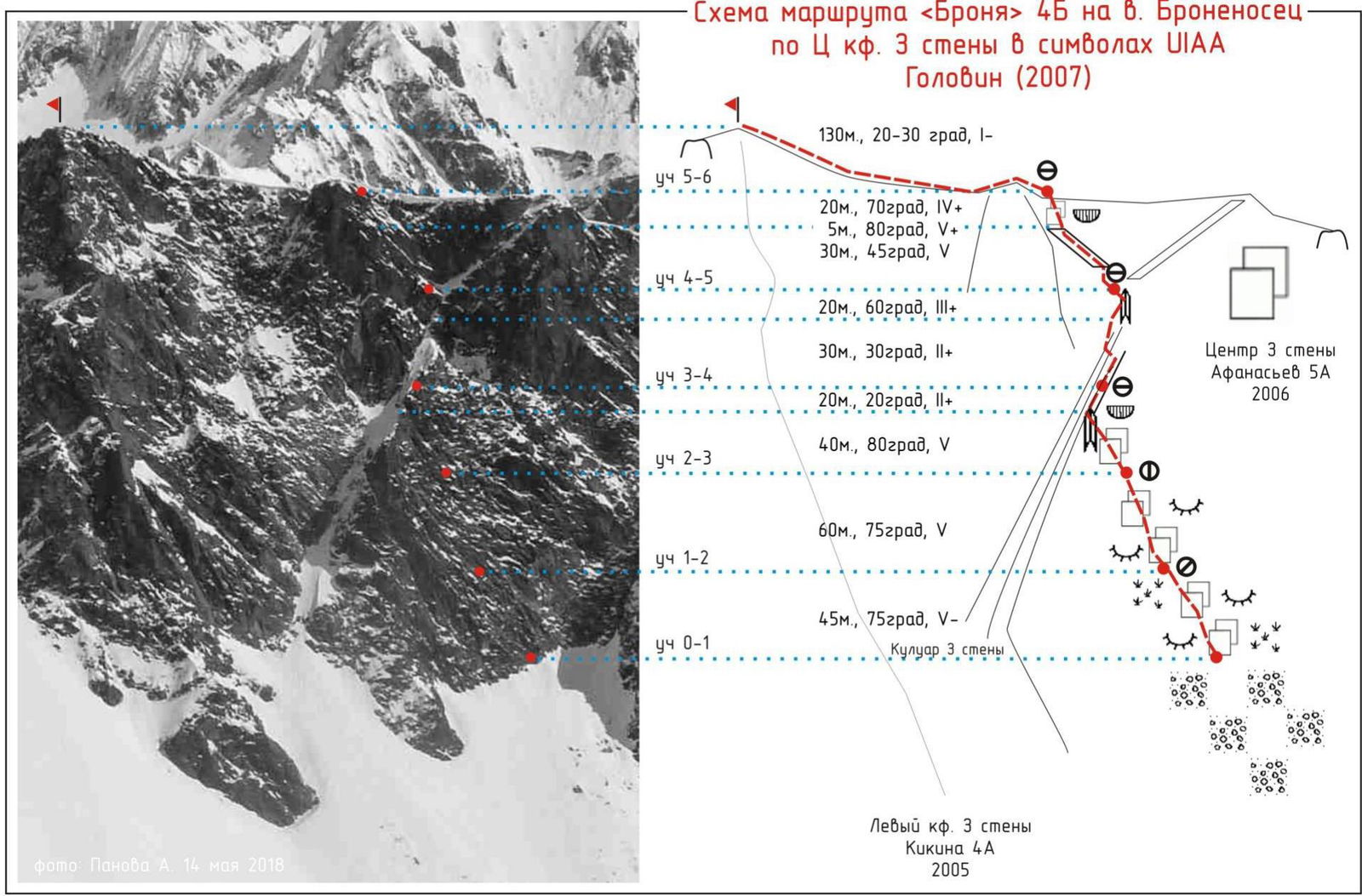
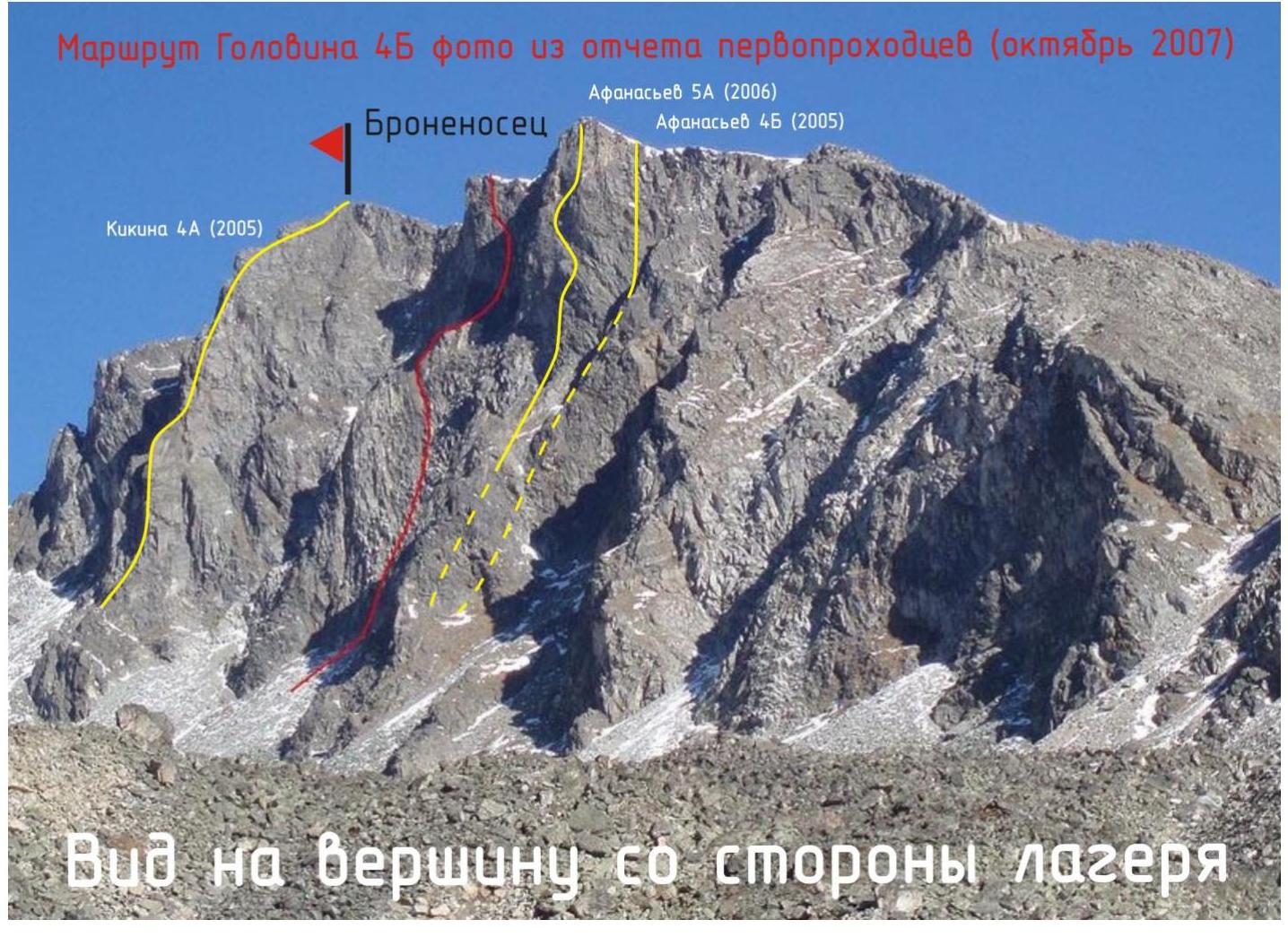 1.1. General photo of the peak from the first ascenders' report. The ascent route is marked in red. Nearby routes are shown as they were at the time of the first ascent (2007). View from the side of BL on October 12-14, 2007.
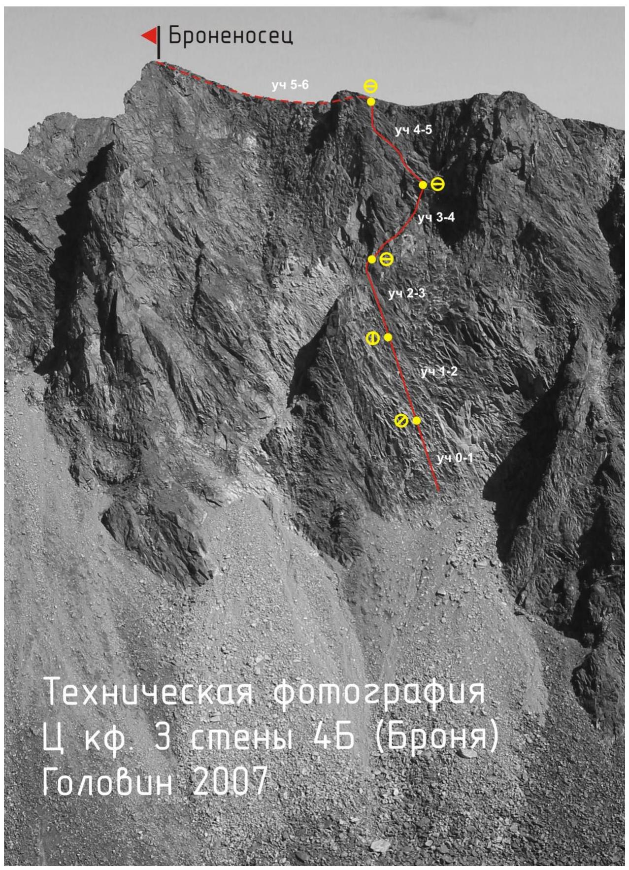
 1.2. Profile of the route. Photo taken from the first ascenders' report.
1.3. Drawn profile of the route (ONLY for routes starting from 5A cat. diff.)
1.2. Profile of the route. Photo taken from the first ascenders' report.
1.3. Drawn profile of the route (ONLY for routes starting from 5A cat. diff.)
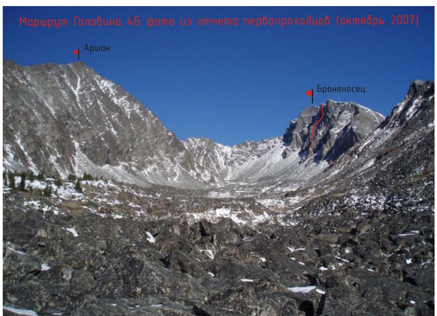
 1.4. Photopanorama of the area. After the mudslide in June 2014, the beginning of the trail from Arshan was lost; the GPS track available at http://www.strava.com/activities/690659752↗ can be used as a reference. Coordinates of the start of the ascent via the trail: 51°54′57.1″ N 102°27′49.4″ E.
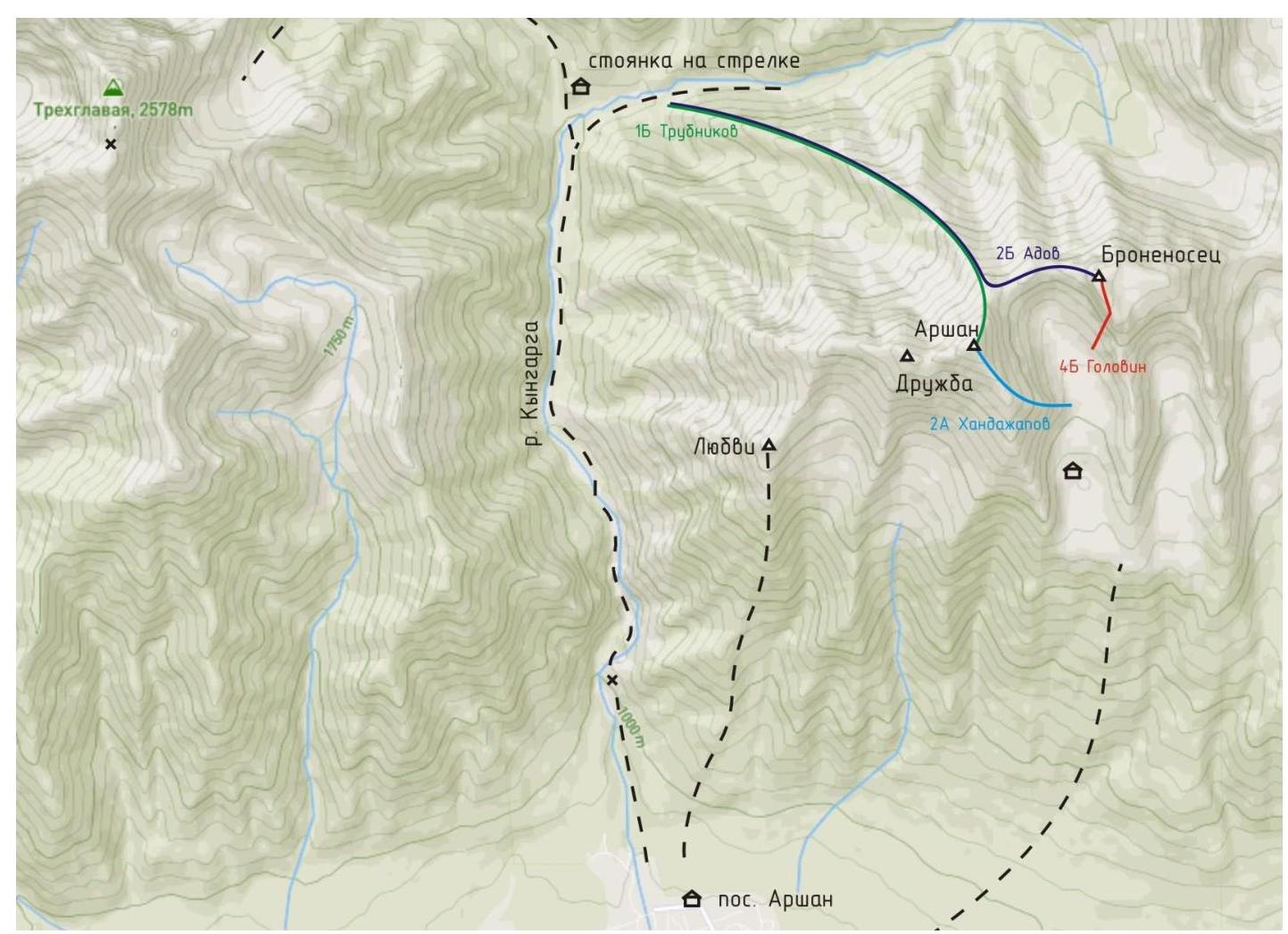 1.5. Map-scheme of the ascent object area. From the village Arshan (900 m above sea level), 3-4 hours along the trail to the hanging cirque Arshan-Bronenosets (1900 m above sea level). From BL to the start of the route via the cirque, about 1-1.5 hours, depending on the snow conditions.
2. Characteristics of the Route
 2.1. Technical photograph of the route. The photograph was taken from the S ridge of peak Arshan in the summer of 2015.
 Left kf. Z wall Kikina 4A (2005)
| Section No. | Anchors | Nuts | Friends | Ice screws | Bolts | Belay stations, characteristics in symbols | Section difficulty in symbols | Section length, m | Steepness, ° |
|---|---|---|---|---|---|---|---|---|---|
| 5–6 | - | - | - | - | - | ∅ | I– | 130 | 20–30 |
| 4–5 | 3 | 2 | 2 | ∅ | IV | 20 | 70 | ||
| 2 | - | 2 | V+ | 5 | 80 | ||||
| - | 5 | - | V | 30 | 45 | ||||
| 3–4 | - | 3 | 1 | - | ∅ | III+ | 20 | 60 | |
| - | - | 2 | 2 | II+ | 30 | 30 | |||
| 2–3 | - | - | 2 | - | ∅ | II+ | 20 | 20 | |
| 2 | - | 3 | V | 40 | 80 | ||||
| 1–2 | 6 | 2 | 7 | - | Φ | V | 60 | 75 | |
| 0–1 | 7 | - | 6 | - | ∅ | V– | 45 | 75 |
3. Characteristics of the Team's Actions
3.1 Brief description of the route ascent. Accompanied by photo illustrations (at least 8 photos, 13×18 cm in size) of key sections of the route, sections of V, VI category of difficulty, characterizing the terrain, steepness, technical means and techniques used, and belay methods. On the photos, the start and end of the section are marked.
| Section No. | Description | Photo No. |
|---|---|---|
| 0–1 | Upwards along the rocks and grassy ledges, gradually moving left. Belay — friends and anchors, uncomfortable semi-hanging station on friends. 45 m, 75°, V− | 1, 2, 3 |
| 1–2 | Continuing movement along the rocks with small ledges to a small vertical slab. Station on this slab on an anchor and nuts. Belay on anchors and friends. Station is uncomfortable, hanging. 60 m, 75°, V | 3, 4 |
| 2–3 | Bypassing the slab on the right, then left upwards to the right internal corner. Upwards along the corner — exit to the counterfort ridge, the section is passed by climbing. Convenient station behind a boulder, belay: friends, anchors. It's better to make a station not immediately after exiting onto the counterfort ridge but after moving about 20 m, which will allow reaching a convenient spot for a station on the next rope (sect. R3–R4). 40 m, 80°, V | 4, 5, 6 |
| 3–4 | Along the counterfort ridge for 30 m, and then along the destroyed left internal corner to the right upwards (20 m, III+) — to a clearly pronounced oblique ledge on the left along the way. Convenient station behind a выступ. | 7 |
| 4–5 | Left upwards 5 m, then along an oblique inclined ledge left 30 m to its end (V, 45°), transition from the ledge left onto rocks (V+, 5 m, 80°) and movement upwards, bypassing нависания, to the main ridge 20 m, IV. | 7, 8, 9, 10, 11 |
| 5–6 | Holding on to the right along the ridge to the peak. 130 m. 20–30°, I– | 12 |
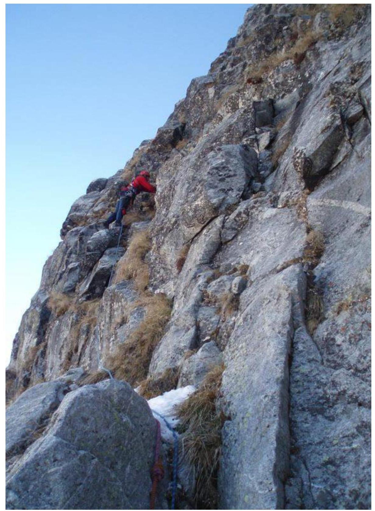 Photo 1. First ascenders at the start of the route. Photograph from the report.
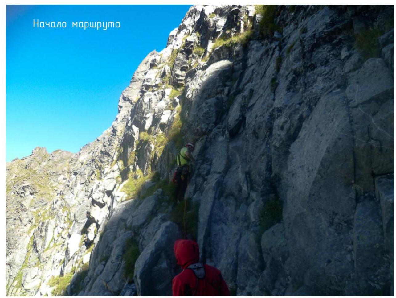 Photo 2. Start of the route. ISAlp — 2018.
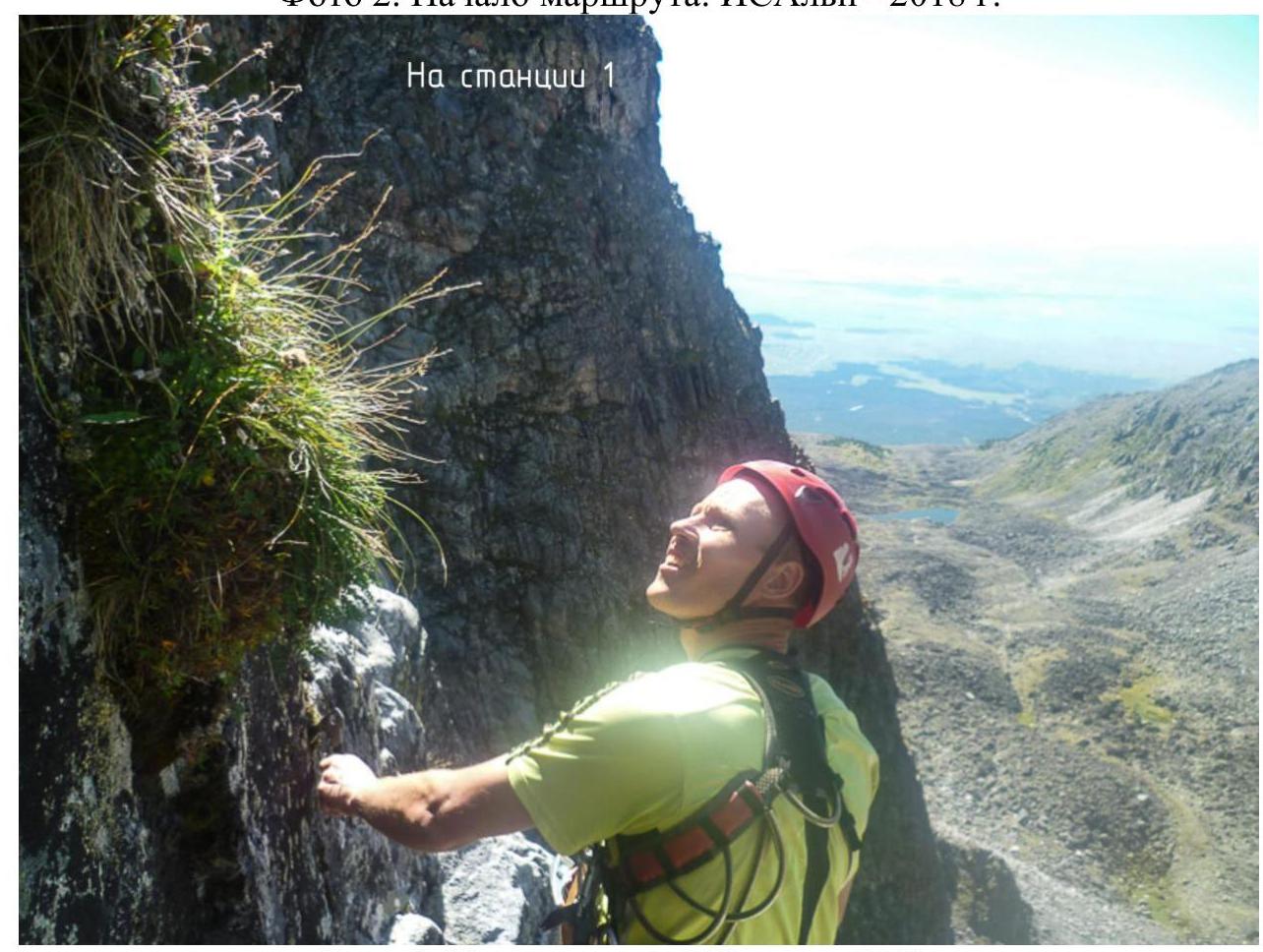 Photo 3. At station 1. ISAlp — 2018.
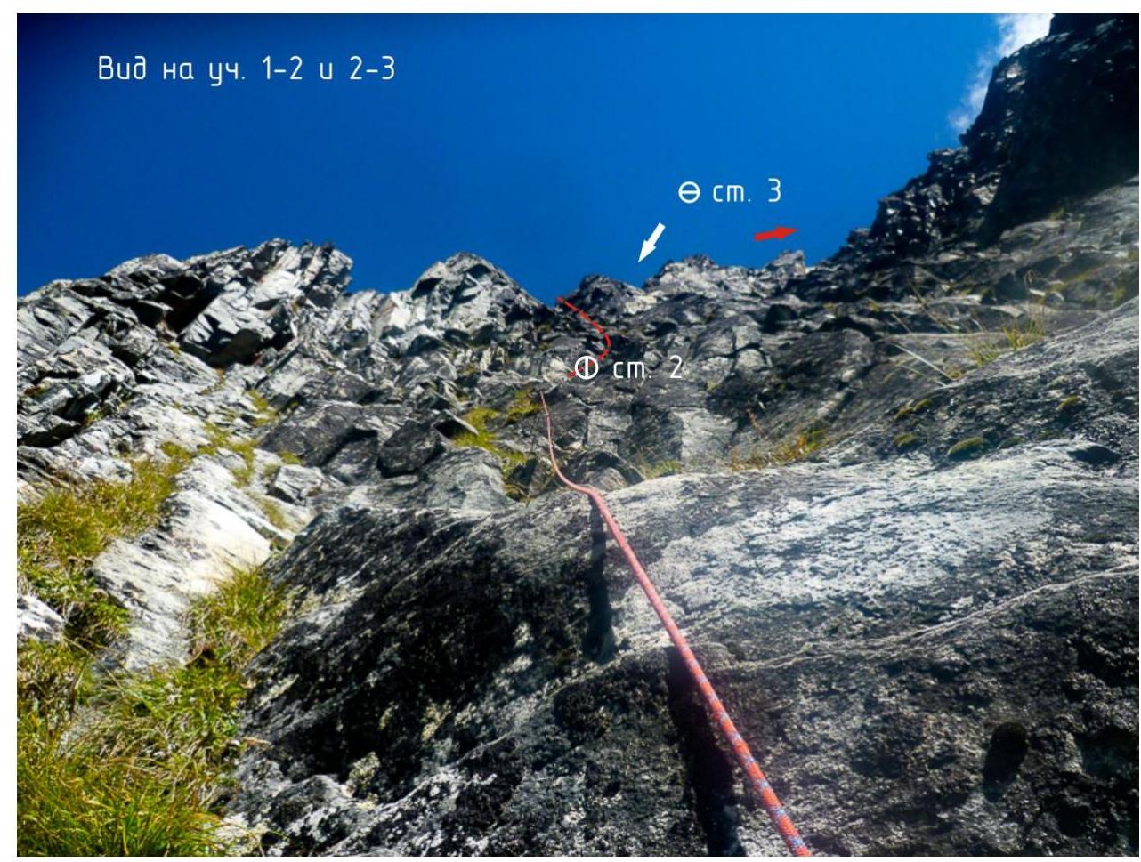 Photo 4. Ropes on sect. R1–R2. ISAlp — 2018.
 Photo 5. From station 2, bypassing the slab on the right. ISAlp — 2018.
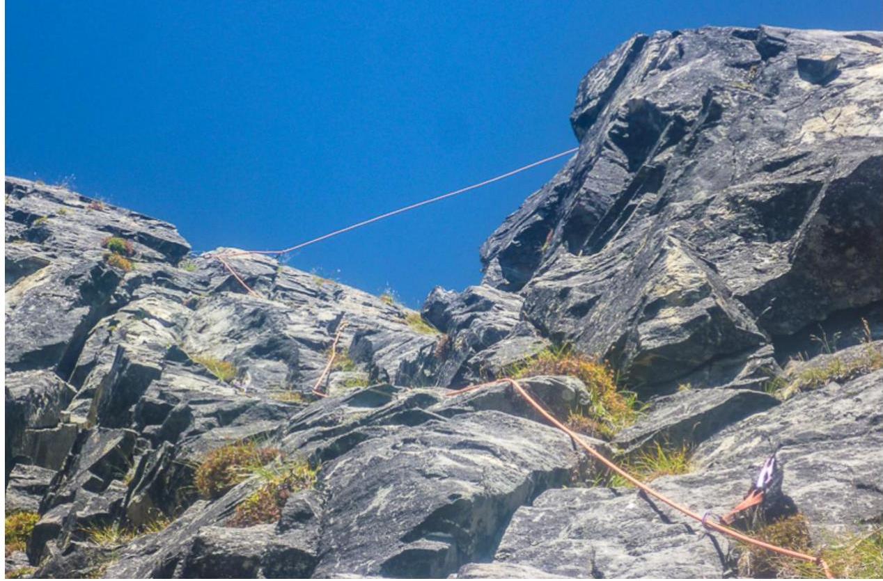 Photo 6. Right internal corner on sect. R2–R3 before exiting onto the counterfort. ISAlp — 2018.
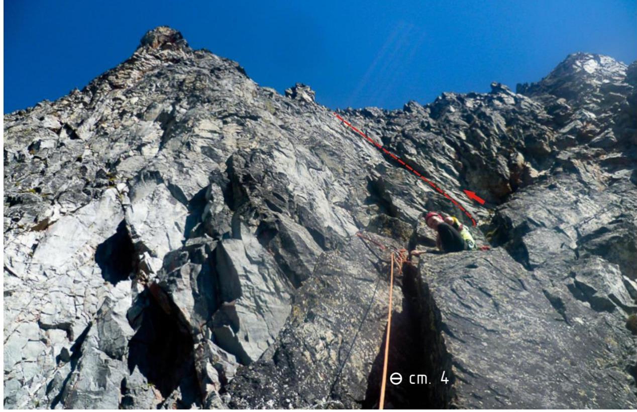 Photo 7. Exit from the left internal corner to station 4. ISAlp — 2018.
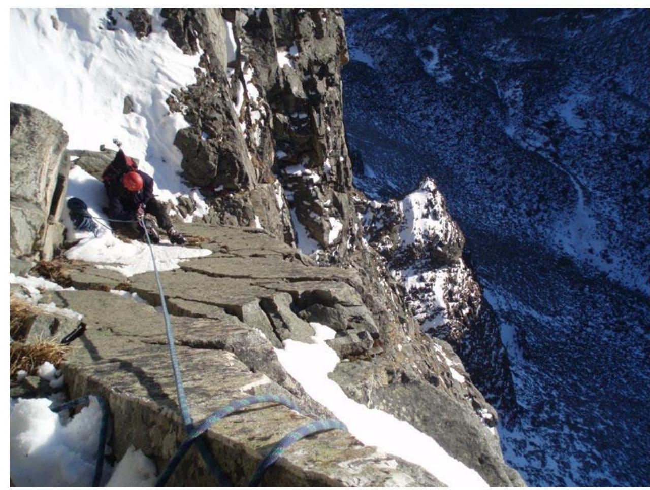 Photo 8. First ascenders at the station before the oblique ledge.
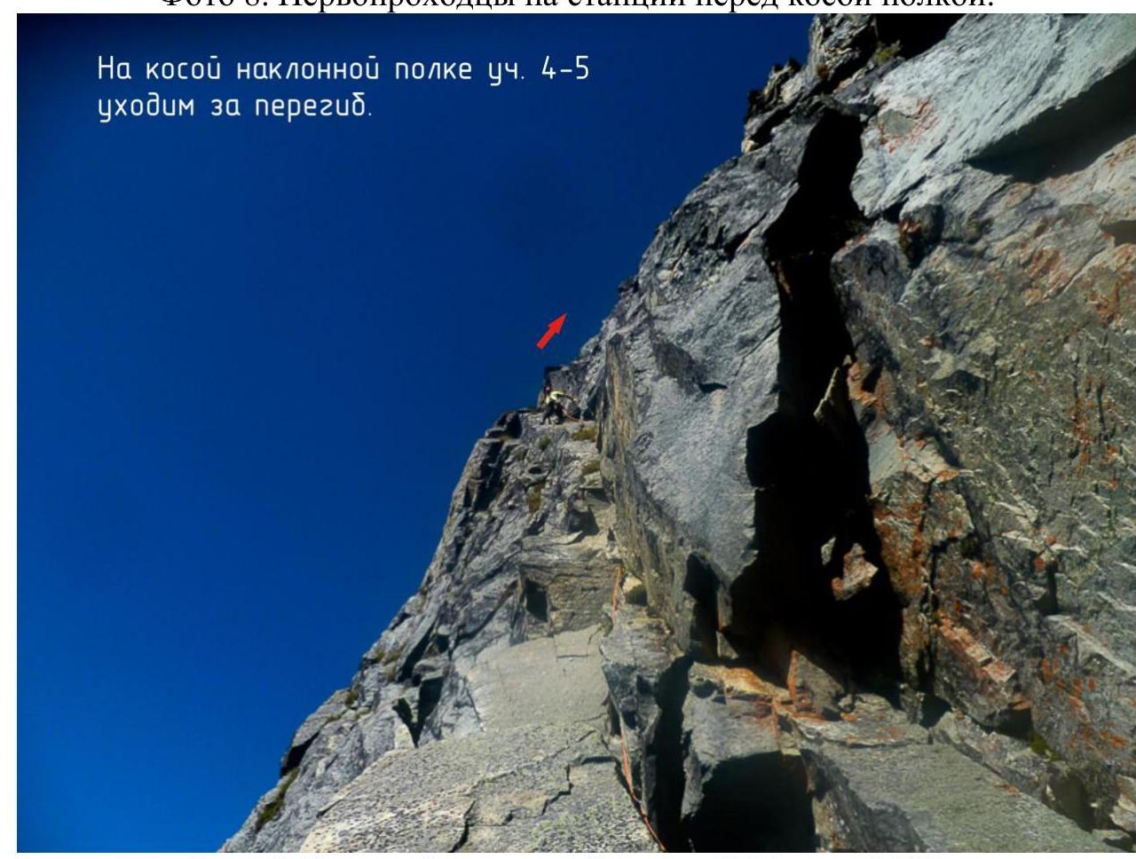 Photo 9. On the oblique inclined ledge. ISAlp — 2018.
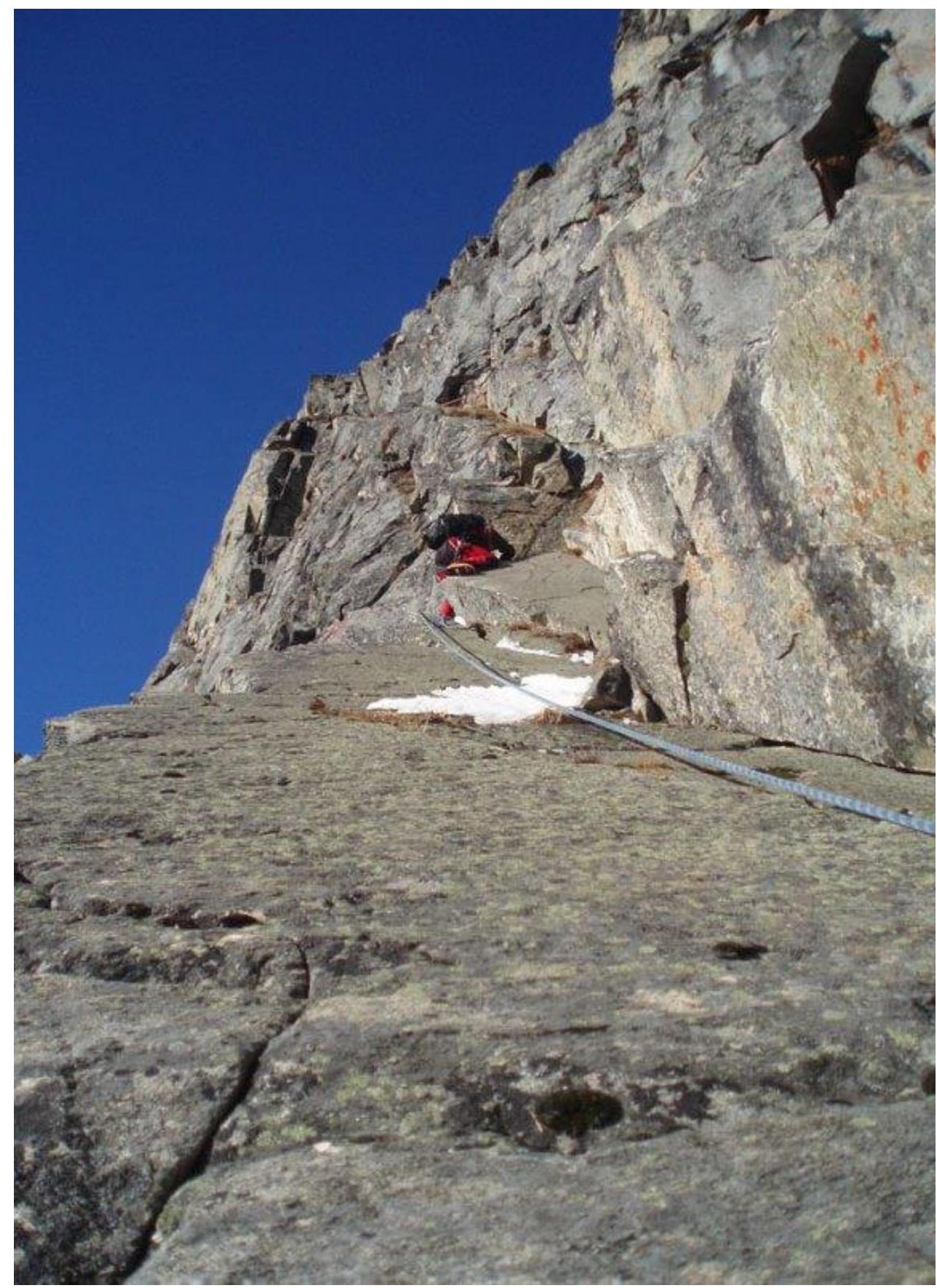 Photo 10. First ascenders on the oblique inclined ledge.
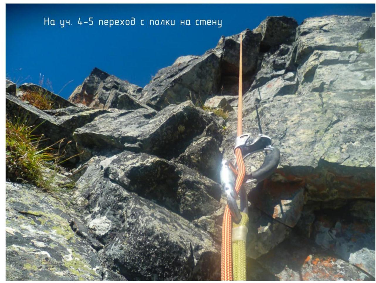 Photo 11. On sect. R4–R5, transition from the ledge to the wall. ISAlp — 2018.
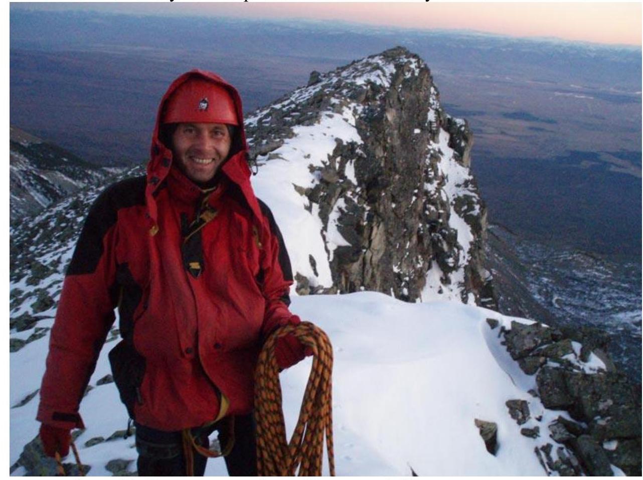 Photo 12. Exit to the ridge. Golovin A.Yu. — route author.
3.2 Photo of the team at the peak near the control tour
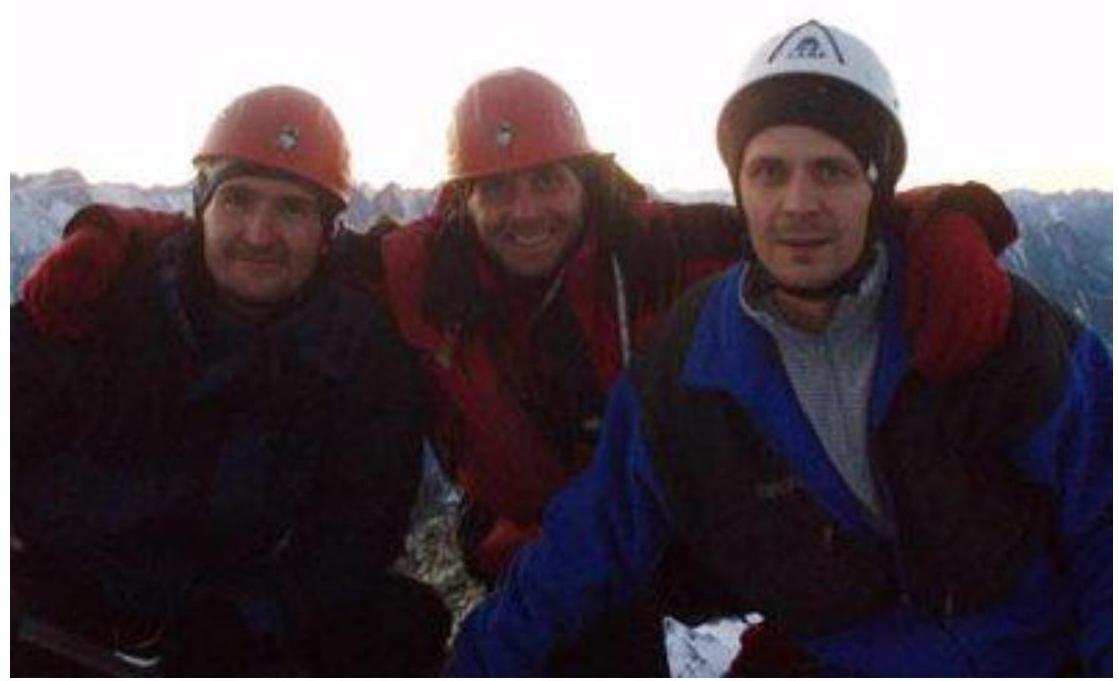 Photo 3.2.1 Team of first ascenders at the peak:
- Zhuravlev E.
- Golovin A.
- Khalov A., photo — Perepechin A. (October 13, 2007).
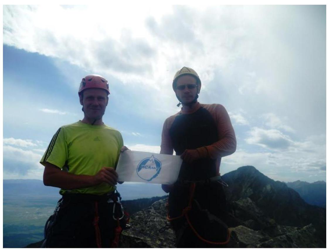 Photo 3.2.2. Team of the Irkutsk Alpine Section at the peak: Korshunov M., Rudman A., photo — Voylichenko S. (August 17, 2018).
3.3. Assessment of route safety.
- Options for communication on the route.
- Recommendations for subsequent ascenders.
- Detailed information about the descent from the peak, indicating landmarks.
- Conclusion on the preliminary assessment of the route compared to classified routes of the same category of difficulty in the team's climbing experience.
The route remains relatively monolithic. Loose rocks are found on ledges, but the route's thread almost always separates the leader and the belayer from the vertical line.
The route is quite popular and has been ascended by several Irkutsk teams; however, reports of these ascents are missing, as is the exact number of ascents — we know of at least four. Our ascent was made using the narrative report, excerpts from which were included in our report. The difficulty of the route claimed by the first ascenders is consistent with similar neighboring alpine routes on peaks Arshan and Bronenosets. Subjectively, the difficulty of the route is between:
- 4A on Arshan Klepikova (2016)
- 5A on Bronenosets Afanasyeva (2006)
These indicated routes were ascended by our team during the same summer under similar favorable weather conditions.
4. Characteristics of Weather Conditions (10)
4.1. Confirmation of data specified in the Ascent Passport with screenshots of weather forecasts from websites: