-
BRONEONOSETs
-
2529
-
2B (via the western ridge)
-
Eastern Sayan, eastern edge of the Tunka Alps (southwestern spur)
-
Total ascent time 7.5 hours
-
From N: Lyevaya Kyngarga river; from S: Left tributary of the Kyngarga river
-
The first ascent via the western ridge was made during the Irkutsk regional alpinist event on May 9, 1976 (event leader — Trubnikov V.I.). Group members: Adov V.G., Pologrudov V.V., Filippova T.M., Nemirovsky Yu.B., Ponamarchuk V.S., Stanevich A.M.
-
Section 1 From the base camp on the Kyngarga river, along the left (orographic) bank of the first left tributary of the Lyevaya Kyngarga river — ascent along the northern ridge of peak Arshan (photo 1). The ascent is not technically difficult. In the upper part, a gendarme is bypassed on the right along the way near a characteristic "tooth" (photo 2). Exit onto the ridge leading to peak Bronenosets between the 1st and 2nd gendarmes of the ridge of peak Arshan. The path takes 3–4 hours from the base camp.
Section 2 (photo 3)
- Get connected on the col.
- The path along the ridge leading from peak Arshan to peak Bronenosets is logical.
- Difficulty — 2A category.
- Small gendarmes are overcome with simultaneous or alternate belay (photos 4,5).
- Time to complete the section — 1–1.5 hours.
Section 3 The first gendarme of the pre-summit ridge of peak Bronenosets is bypassed on the left along snowy slabs (photos 3 and 6). The second gendarme is overcome head-on. The ascent consists of two sections, each 10–15 m long and with a slope of about 60° (photos 7,8). Between the sections, on a wide ledge, it is necessary to organize belay. Ropes are desirable. Difficulty 2B category. The third gendarme is bypassed on the left along slabs with an exit to the top of the gendarme (photos 9,3). The length of the difficult section is 30 m. Difficulty 2B–3A. Passing this section takes 1.5 hours. From the third gendarme, there is a straightforward ascent to the summit (15–20 minutes). From the summit, descend along the uncomplicated wide eastern ridge to the col, and then along the Lyevaya Kyngarga river to the base camp (photo 1). The path from the summit to the base camp takes about 3 hours.
-
Equipment for a group of 6 people
- main ropes — 3/40
- rock pitons — 3–4
- hammers (ice axes) — 2
-
Recommendations for climbers: when descending, beware of small avalanches from the right side of the Kyngarga river valley.
-
Table of main characteristics of the ascent route
| Date | Sections completed | Pitons used | Average slope | Length and time | Terrain | Category of difficulty | Belay method |
|---|---|---|---|---|---|---|---|
| May 9, 1976 | 1 | 20° | 2000 m, 3.5 hours | Snow | 1A | Simultaneous | |
| 2 | 0° | 500 m, 1.5 hours | Rock | 2A | Alternate | ||
| 3 | 35° | 200 m, 1.5 hours | Rock | 2B–3A | Alternate | ||
| 4 | 25° | 1500 m, 1 hour | Snow | 1A | Simultaneous |
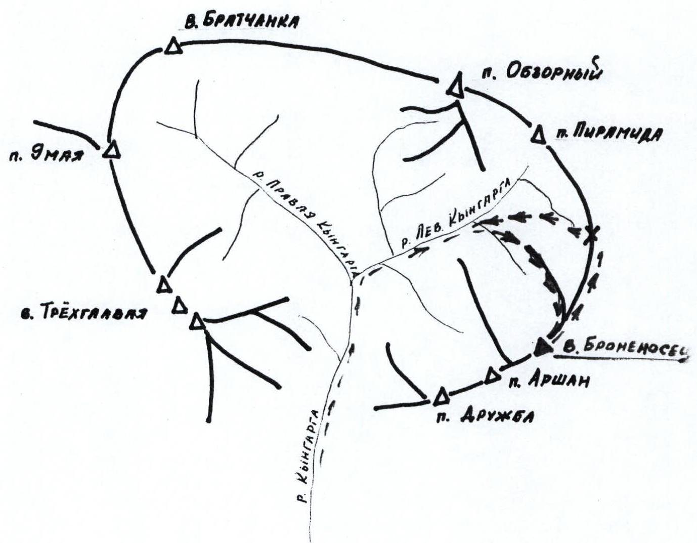
OROGRAPHIC SCHEME