Group Composition
- Krasnukhin L.M., leader, 2nd sports category
- Trubnikov V.I., Master of Sports
- Shvab A.E., 1st sports category
- Rasputin A.K., 2nd sports category
- Slastnikova T.E., 2nd sports category
The route was completed on October 27, 1976.
Brief Geographical Overview
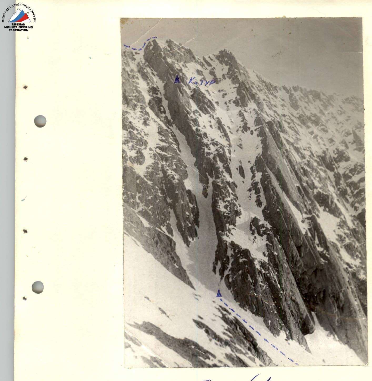
Peak 2501 is located in the main watershed ridge of the Tunkinskie Goltsy range, Eastern Sayan, in the upper reaches of the Pravaya Kyngarga River gorge. To the south, the peak drops with steep rocky walls featuring three counterforts — left, central, and right, with an average steepness of 45°. (photo #1) To the north lies a steep, heavily dissected, and destroyed slope. To the east, it descends into a long, sharp ridge, continuing the main ridge of Tunkinskie Goltsy.
Up to an elevation of 1100 m, the slopes are covered with forest.
Climatic Information
The climate of the region is sharply continental. The average temperature during winter months is 30–40 °C. In summer, compared to the valley, cloud cover increases in the mountains, and precipitation is frequent. Large diurnal temperature fluctuations are characteristic. Precipitation in the warm period reaches 500 mm, and up to 1000 mm in winter. The maximum snow cover depth occurs in February and early March.
The winter period lasts from October 10 to May 15. From November to mid-May, the rivers of Sayan are ice-bound, and deep, loose snow lies in the gorges. By May, some open snowfields become firn, but the snow generally retains its looseness until it melts. Features include:
- Ice fields along the river gorges
- Icings persist until mid-July.
Route Description
From the base camp at the confluence of the Levaya and Pravaya Kyngarga rivers (elevation 1202 m), move along the Pravaya Kyngarga River gorge to the forest boundary. Then, turning left in the direction of travel, overcome a long, gentle rise of an old moraine, leaving a long rib to the right that extends perpendicularly from the main ridge, and enter the cirque beneath peaks 90th May and 2501 m. (The total approach takes 2.5–3 hours).
Continue along a wide snow couloir (30–40°) to the base of the central counterfort (30–40 m). (photo #1). The beginning of the counterfort is a gendarme with destroyed rocks. Ascend directly forward along the outer angle. Climbing is moderate, with alternating belays (two ropes). (photo #2, section R1).
Then, having passed a rocky knife, exit under the inner angle. Move straight up the angle, exiting onto simple, gentle rocks. Belay is with pitons. (40–50 m). (photo #3, section R2).
Further along simple rocks, bypass a large overhanging stone on the right (50–60 m), (photo #4, section R3) — approach beneath a snow-covered inner angle. Move upward along the angle. Belay is with pitons. (30–40 m). (photo #4, section R4).
Exit onto the counterfort ridge. Bypass a second large stone on the right and, along a wide, destroyed rocky angle, again exit onto the ridge.
Control traverse. Belay:
- along the ridge — simultaneous,
- along the angle — alternating.
80 m (photo #5, section R5).
From the control traverse, movement is simultaneous. The counterfort ridge is cut by powerful projections. (40–50 m). (photo #6, section R6).
The next, penultimate section is the key section of the route. It is an inclined, snow-covered slab with a small number of holds. The average steepness is 55–60°. Belay is with pitons. (40 m). (photo #7, section R7).
Exit onto the main ridge. Continue along the 1B category of difficulty route to the summit (photo #8, section R8).
Descent is also along the 1B category of difficulty route. The total time taken to complete the route and return to the base camp is 10 hours.
Table of Main Route Characteristics by Sections
| Section | Length | Steepness | Relief Characteristics | Technical Difficulty |
|---|---|---|---|---|
| R1 | 80 m | 45° | gendarme, rocks destroyed and cut by projections | moderate |
| R2 | 40 m | 45° | inner rocky angle | moderate |
| R3 | 50–60 m | 45° | snow-covered inner rocky angle | moderate |
| R4 | 50–60 m | 50° | snow-covered rocky angle with icing | moderate |
| R5 | 80 m | 30° | counterfort ridge cut by projections, rocky ridge | easy |
| R6 | 40–50 m | 45° | counterfort ridge with projections | easy |
| R7 | 40 m | 55–60° | snow-covered slab | difficult |
| R8 | 200 m | 39° | snow-covered ridge | easy |
Training Characteristics of the Route by Sections (Passage)
| Method of Overcoming and Belay | Weather Conditions | Departure | Time Taken | Pitons Driven (Rocky) | Ice |
|---|---|---|---|---|---|
| Alternating belay via projections | good, T –10–15° | 6:00 | 0:20 | - | - |
| Alternating belay, pitons, and via projections | good | 0:30 | 1 | - | |
| Alternating belay, pitons, and via projections | -//- | 0:40 | 2 | - | |
| Alternating piton belay | -//- | 0:40 | 1 | - | |
| Simultaneous | -//- | 0:20 | - | - | |
| Simultaneous | good | 0:30 | - | - | |
| Rappel 40 m | -//- | 1:00 | 2 | - | |
| Simultaneous | wind, T –15–20° | 0:20 | - | - |
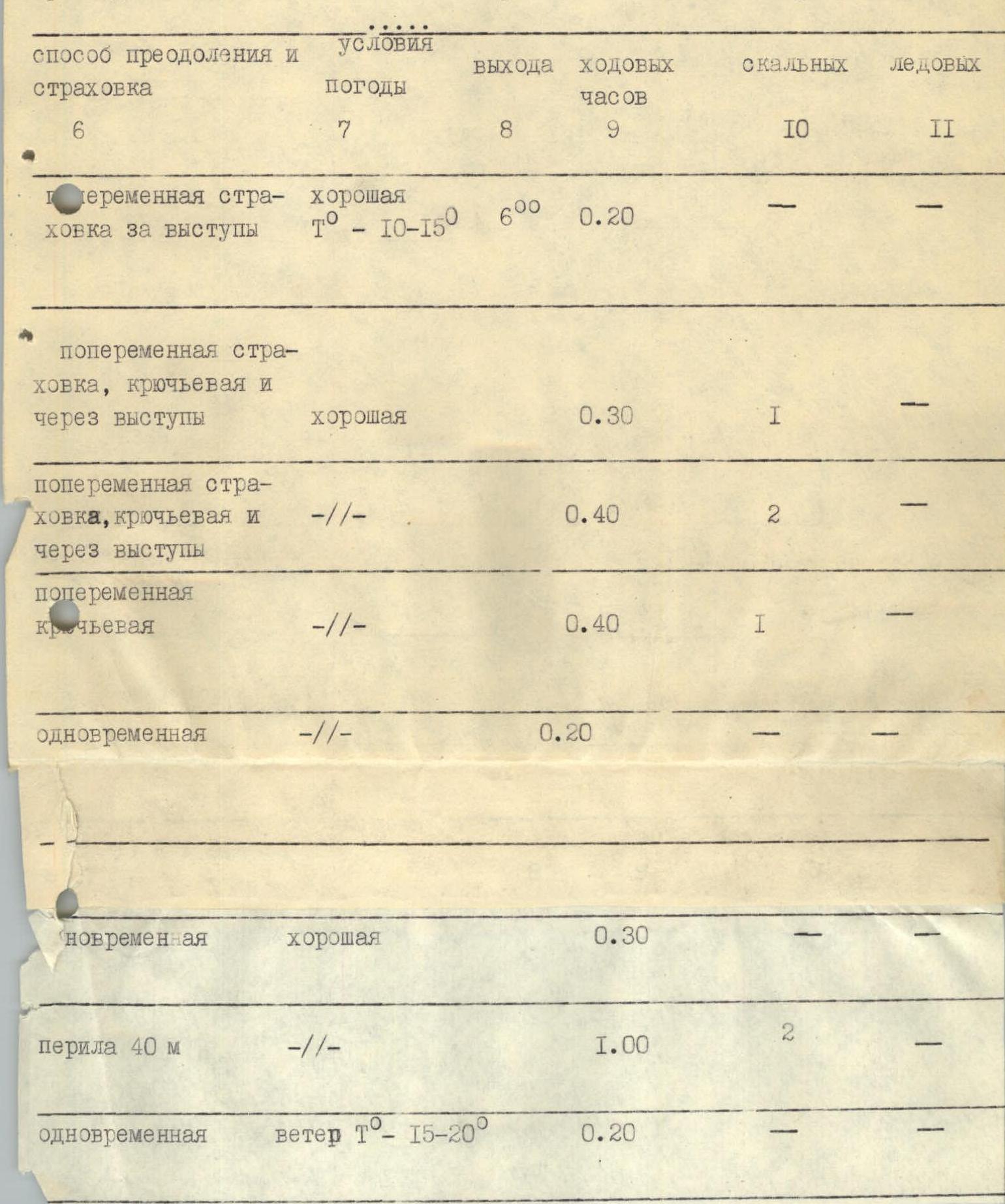
Photo #8 Section R8
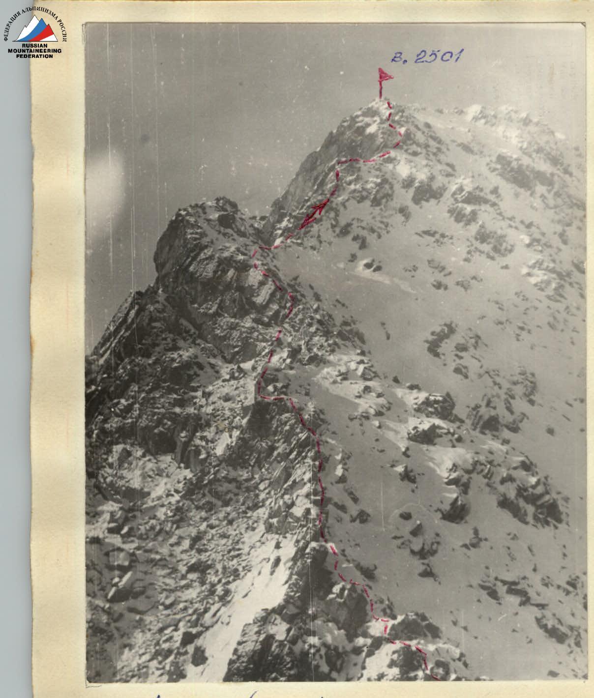
Photo #7 Section R7 (Taken from the main ridge)
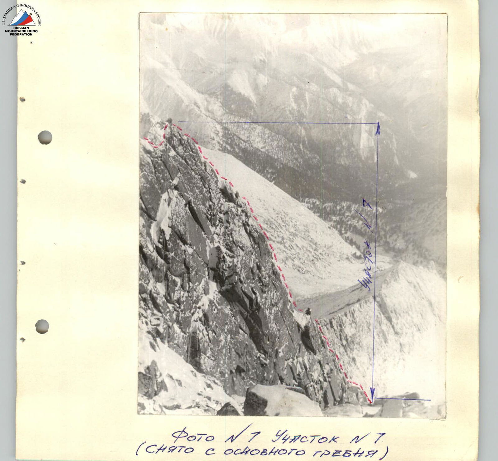
Photo #2 Section R1
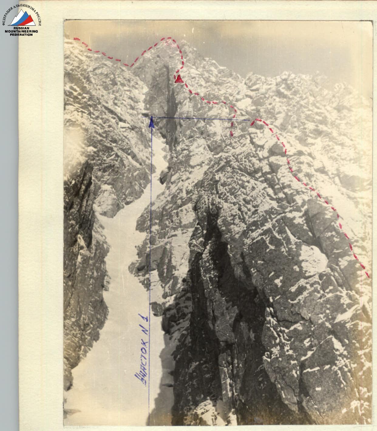
Photo #1