- Climbing category - technical.
- Climbing area, ridge - East Sayan, Tunkinskie Goltsy.
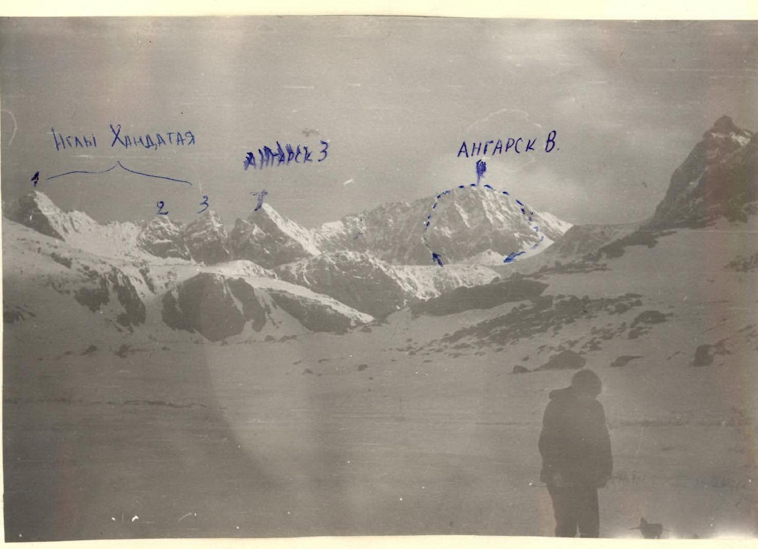
- Peak, its height, ascent route - p. Angarsk Vostochny, 2691 m, via the left buttress of the 0-3 wall.
- Proposed category complexity - 3B.
- Height difference - 700 m, average steepness - 47°.
- Number of pitons driven - 15 rock pitons.
- Number of climbing hours - 14 hours.
- Number of overnight stays - none.
- Surname, name, patronymic of the leader, participants and their qualification: 9.1. Donskoy Konstantin Dmitrievich, 1st sports category - leader. 9.2. Maslov Sergey Innokentievich, 1st sports category 9.3. Nikonov Viktor Petrovich, Candidate Master of Sports 9.4. Yurinsky Yuri Ivanovich, 1st sports category 9.5. Nikonova Irina Mikhailovna, 1st sports category
- Team coach - Nikonov Viktor Petrovich.
- May 5, 1980.
 General view
 Area map.
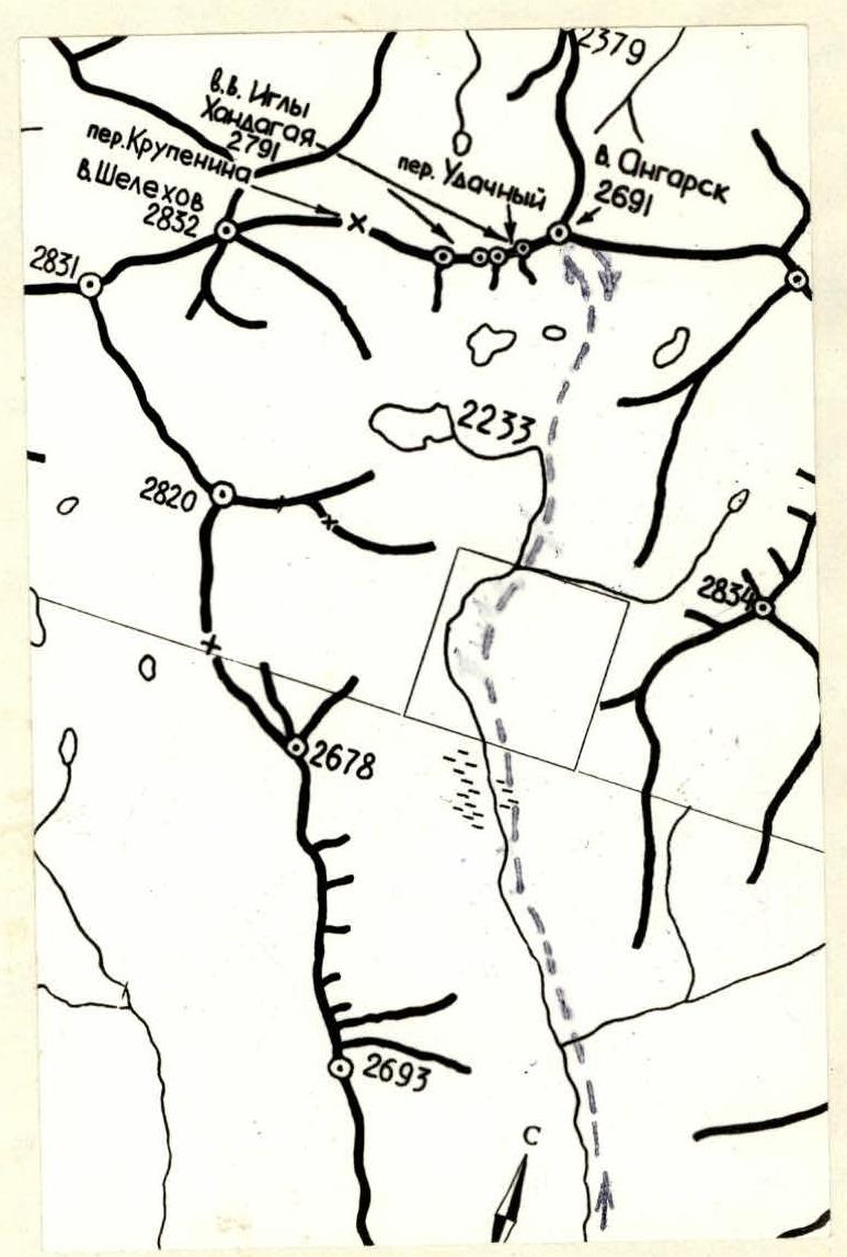
Table - main characteristics of the ascent route
| Covered sections | Average steepness of the section | Length of the section (by length) | Terrain characteristics | Category of difficulty of the section | Method of overcoming and belaying | Weather conditions | Time of bivouac stop, exit, climbing hours | Rock pitons | Ice pitons | Bolt pitons | Overnight stay conditions |
|---|---|---|---|---|---|---|---|---|---|---|---|
| R0–R1 | 45° | 160 m | Snowy couloir, ledges, walls | 3 | Alternating, pitons, ledges | Clear, –5 °C | 8:00 | 5 | – | – | – |
| R1–R2 | 45° | 160 m | Slabs, blocks, snowy ledges, couloir | 2 | Alternating, ledges | Clear | – | 1 | – | – | – |
| R2–R3 | 50° | 40 m | Walls | 3 | Alternating, ledges, pitons | Clear | – | 3 | – | – | – |
| R3–R4 | 45° | 160 m | Walls, narrow buttress, snowy drifts | 3 | Alternating, ledges, pitons | Snow | – | 1 | – | – | – |
| R4–R5 | 70° | 40 m | Wall, tower, snowy cornice | 4 | Alternating, pitons | Snow | – | 5 | – | – | – |
| R5–R6 | 30° | 120 m | Narrow ridge of blocks, summit | 3 | Simultaneous, alternating | Snow, blizzard | At the summit, 876.00 | – | – | – | – |
Description of the first ascent route to v. "Angarsk" via the left buttress of the southwest wall
Exit from the base camp at 6:00. Approach to the route at 9:00.
Section R1. The route begins along an oblique couloir to the foot of the buttress. We go along the top of the left bank. Relief:
- steep snowy grassy ledges;
- rock walls;
- snowy slabs 160 m.
Piton belay, control tower. Steepness of the section 45°. Exit to the buttress. (Photo # 1)
Section R1–R2. Then up to the right with a traverse of inclined slabs, transition through the buttress crossbar up to steep blocks. (Photo # 2, 3) Ledges, alternating 40 m. Then up steep snowy blocks another 40 m. Approach to the wall 40 m. From the wall, along the snow to the right, exit through the couloir, left to the crossbar 60 m (Photo # 4). Steepness 30–35°.
Section R2–R3. Two walls - 15 m and 10 m. Overall steepness 50°. Monolithic rocks. 3 pitons, ledges. (Photo # 5).
Section R3–R4. Further, the buttress is a narrow step-like relief with vertical snowy walls 3–4 m and large snowy drifts on the ledges 160 m. Overall steepness of the section 45°. Belay through ledges. (Photo # 6).
Section R4–R5. Snowy wall with a steepness of 60° to the left of the route 10 m. 2 pitons lead to a snowy crossbar with a cornice under the tower on the main ridge to the summit (Photo # 7, 8). The tower is passed head-on, vertical, 80–85°, 10 m. At the top of the tower, a cornice (4 pitons). We cut through the cornice and exit to the ridge on the crossbar behind the tower. To the right is a large cornice.
Section R5–R6. Further along the narrow destroyed ridge 120 m. Overall steepness 30° to v. Angarsk. Descent via route 2A.
Time to the summit - 8 hours. Descent via 2B - 1 hour. To the camp from the summit - 2 hours. Total time - 14 hours.