Ascent report.
- East Sayan, Bolshoy Sayan ridge, Moguvek gorge, section 6.1.
- Solnechnaya peak (Tychen-Ardyn), 3192 m, via North-Eastern ridge.
- Proposed category 2B, first ascent.
- Route type — rocky.
- Height difference 300 m, length 810 m, average slope 30°.
- Pitons used: rock and wired 8 pcs.
- Team's travel time — 5 hours.
- No overnight stays.
- Group:
- Dorofeeva E. — 2nd sports category
- Afanasyev A. E. — Candidate Master of Sports
- Kapustina T. D. — Master of Sports
- Mayorov E. — 3rd sports category
- Rusak G. — 3rd sports category
- Yakovenko A. N. — Candidate Master of Sports
- Coach — Mikhailov A. A., Master of Sports
- Departure to the route and return — January 1, 1984.
The first ascent to Solnechnaya peak via the proposed route was made in 1977 by a group led by V. P. Bryansky.
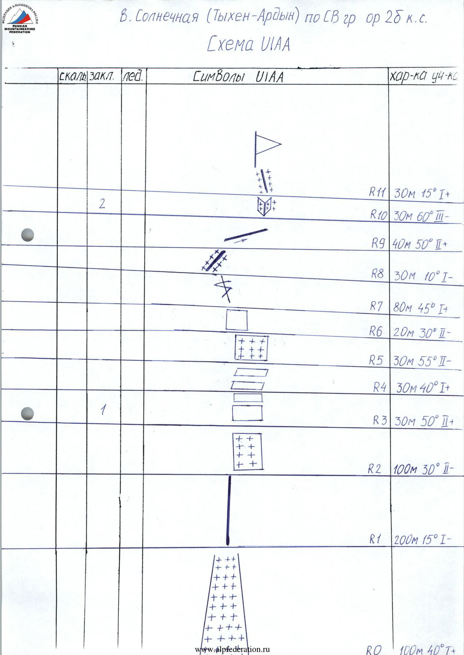
Description of the ascent route to Solnechnaya peak (Tychen-Ardyn) 3192 m via North-Eastern ridge
Category 2B.
R0 100 m. 40°, 1. Snowy couloir. Ascent to the pass. R1 200 m. 15°, 1. Rocky ridge. R2 100 m. 30°, 2. To the right of the ridge along snowy slabs. R3 30 m. 50°, 2. Large-block fractures. Exit to the ridge. R4 30 m. 40°, 1. Series of ledges. R5 30 m. 55°, 2. Snowy rocks. R6 20 m. 30°, 2. The rusty wall is bypassed on the left. R7 80 m. 45°, 1. Large crevice to the left. Exit to the shoulder. R8 30 m. 10°, 1. Snowy shoulder. R9 40 m. 50°, 2. Traverse of the destroyed slope to the right of the ridge. R10 30 m. 60°, 3. Destroyed snowy inner corner. R11 30 m. 15°, 1. Ridge crest. Exit to Solnechnaya peak.
Solnechnaya peak (Tychen-Ardyn) via NE ridge. Category 2B.
UIAA Scheme