Ascent Passport
- Ascent class — technical
- Ascent area — Eastern Pamir
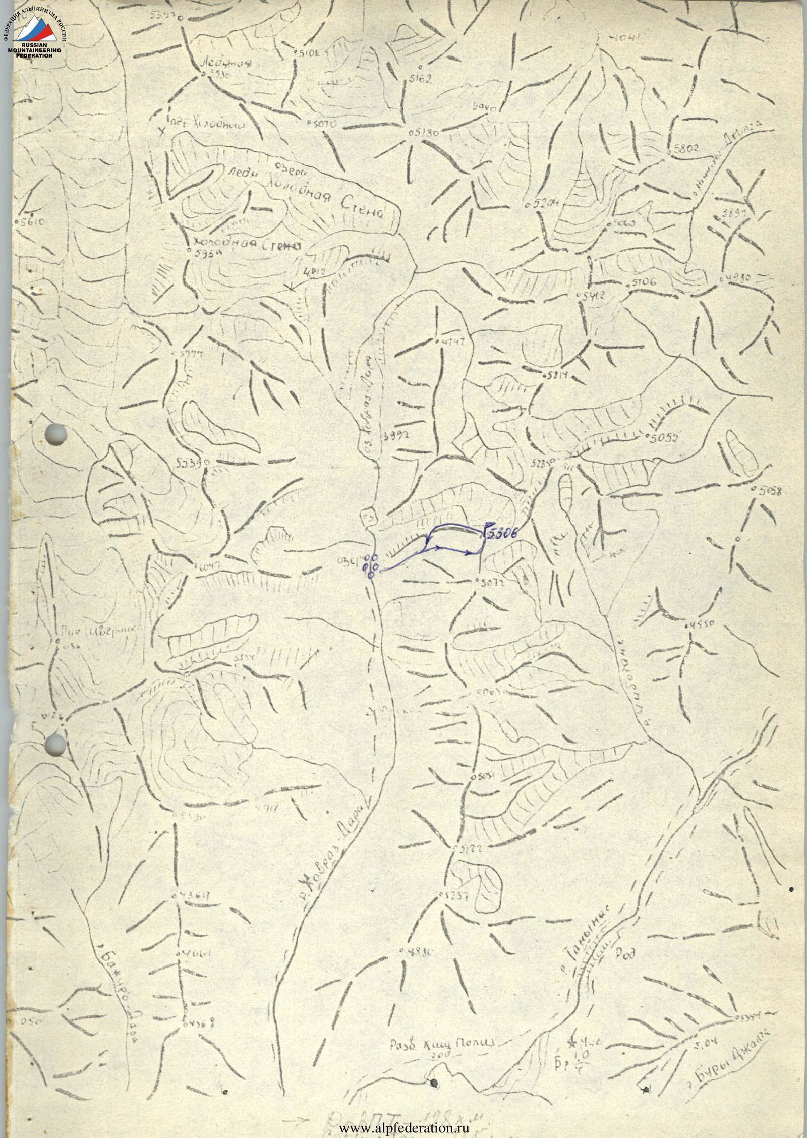
- Peak, its height, ascent route — p. 5306 (Ukrainian “Burvestnik”) via the southern ridge
- Estimated difficulty category — 4A
- Route characteristics:
height difference — 385 m, length — 1290 m, average steepness of the route — 20°, average steepness of the wall section — 60°, length of sections:
– 1st difficulty category — 160 m – 2nd difficulty category — 395 m – 3rd difficulty category — 630 m – 4th difficulty category — 10 m – 5th difficulty category — 100 m – 6th difficulty category — absent
-
Pitons driven: of which for ITO: rock — 8 ice — закладных — 16 bolts —
-
Number of travel hours — 7.5 h
-
Number of overnight stays and their characteristics — none
-
Surname, name, patronymic of the leader and participants, their sports qualification:
-
Sopov A.M. — 1st sports category — Kiev — leader
-
Derkach A.A. — Candidate for Master of Sports — Kiev — participant
-
Kovtun N.P. — Master of Sports — Kiev — participant
-
Khariniak I.V. — Candidate for Master of Sports — Kiev — participant
-
Team coach — Kovtun Vasily Grigoryevich
-
Date of departure on the route and return:
August 12, 1980
Organizational and Tactical Ascent Plan
The combined team of the Ukrainian Council of the “Burvestnik” Sports Society for mountaineering began preparations for ascents for the summer season of 1980 in the autumn-winter period of 1979 and completed it in the spring of 1980.
In the mountains, before this ascent, all participants made a number of ascents of 1–5 difficulty categories.
A reconnaissance exit was carried out under the route by the duo Kovtun–Sopov. The route was repeatedly viewed from various points in the area.
Based on the observations, a tactical plan was drawn up:
- August 12, 1980 — departure on the route, its passage, and return to camp.
- August 13, 1980 — reserve day in case of bad weather.
The planned tactical plan was executed.
Safety Measures
The safety of the ascent was ensured primarily by the good preparation of the participants, as well as by the rescue team located in the base camp. Stable radio communication was maintained with the camp. Part of the route was visually monitored. The group was provided with:
- high-quality equipment;
- a wide range of pitons.
The group had a tent, a primus stove, and warm clothing. The set of products also met the requirements of climbers.
Description of the ascent route to p. 5306 (Ukrainian “Burvestnik”) via the southern ridge
- Approach:
- From the bivouac below the small lakes, cross to the left bank of the Khovraz-Dara river via a bridge.
- Along the grassy slopes, up to the right, beyond the characteristic rock outcrops, and along the small and medium talus, reach a gentle slope leading to the base of the right western counterfort of the southern ridge.
- Along the right part of the steep large talus, ascend to the pass between peaks 5306 and 5072.
From the initial camp, 3–4 h.
- Ascent: From the pass, along an osypnaya polka (scree ledge) 60 m to the right, up to a characteristic overhanging cornice. To the left of the cornice, along steep 70° monolithic large-block rocks with wide vertical cracks, 80 meters straight up to a horizontal osypnaya polka (scree ledge). Climbing is complex. Along the ledge to the right to its end (10–15 m), then up to the left of the overhanging stone along steep complex rocks 10 m and along simpler, more gentle rocks with short ledges to the eastern slope of the southern ridge (15–20 m). Throughout the section, insurance is with pitons.
Along the eastern slope of the ridge, up along the scree (60–80 m). Then, along large-block rocks with small (2–3 m) smooth walls, to the right, up to the southern ridge (100–150 m). To the left along the ridge to the shoulder. Control tur (cairn).
Along the ridge, bypassing small gendarmes to the right along simple rocks to the ascent of the southern summit (250–300 m). Traverse to the right-up 120 m to an inclined chimney. Up the chimney 10 m (climbing is complex) to a 5–8 m ledge under an 8-meter wall. Along the right part of the wall (climbing is complex) to the shoulder of the ascent. Further along simple rocks 100–120 m to the southern summit. On the summit, a control tur (cairn).
From the summit, descend to the west along the boundary of snow and rocks 40–50 m to an ice lake.
Bypass the lake on the left along the snow. Without going out to the ridge (cornice!), down along the steep dense snow (insurance through an ice axe) 40 m and further 50–60 m along the ridge to the rocks of the ascent of the summit. Along rocks of medium complexity to the left, up and up 180–200 m to the summit 5306. 3–5 m below the summit, on a horizontal site, a control tur (cairn). From the pass, 7–8 hours. Descent along the long western ridge (approximately 2A category of difficulty) and further along the osypnye polya (scree fields) to the bivouac at the lower lakes (2.5–3 hours).
Passage of section 1–2
Passage of section 3–4
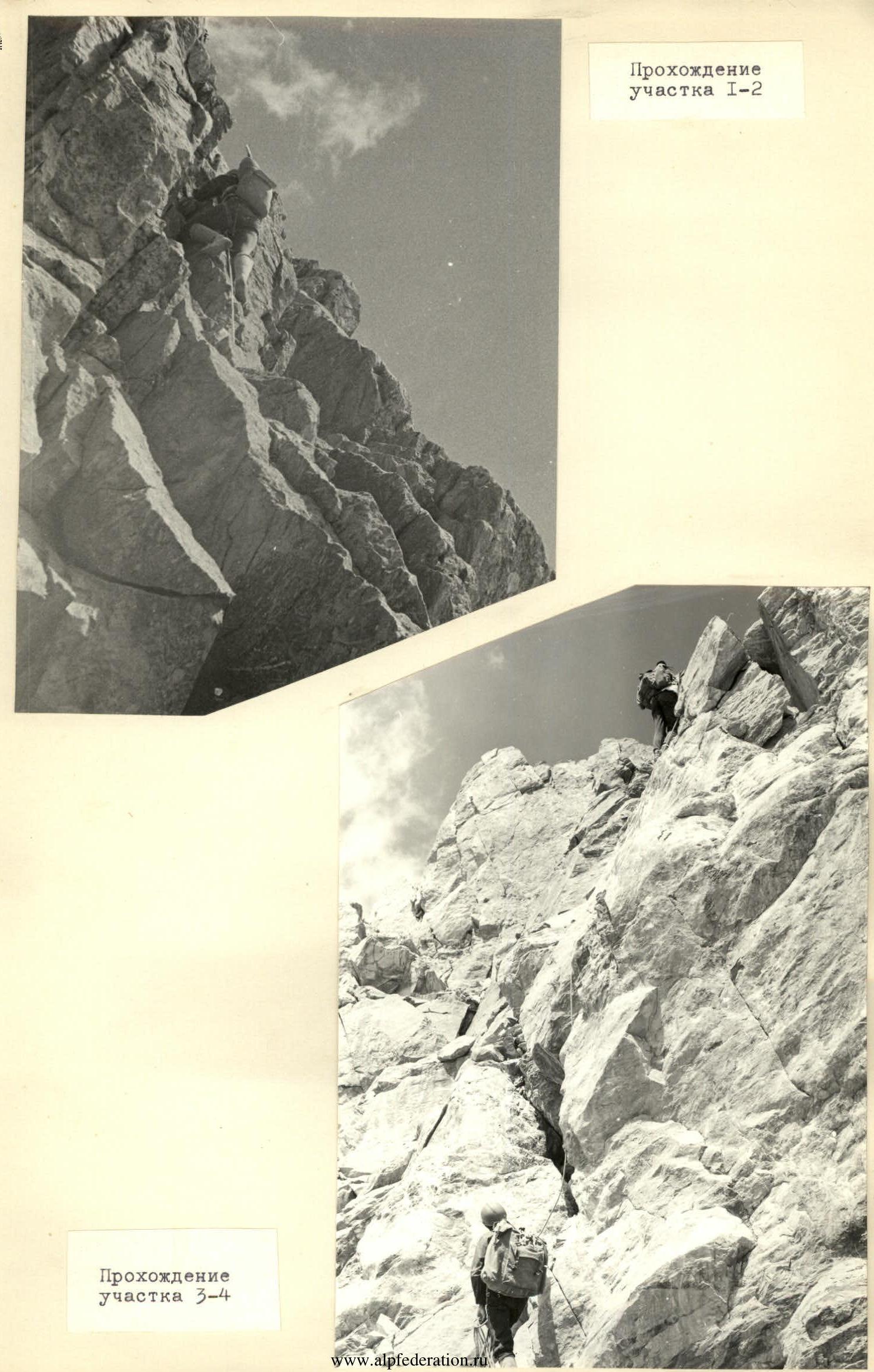
Table of Main Route Characteristics
August 12, 1980
| Designation | Average Steepness | Length | Relief Character | Difficulty | Condition | Weather Conditions | Rock Pitons | закладные Pitons |
|---|---|---|---|---|---|---|---|---|
| 0–1 | 30° | 60 m | oblique ledge | 1 | scree | good weather | ||
| 1–2 | 70° | 80 m | wall | 5 | monolith | “ | 4 | 12 |
| 2–3 | 0° | 15 m | ledge | 2 | scree | “ | ||
| 3–4 | 70° | 10 m | wall | 4 | monolith | “ | 1 | 2 |
| 4–5 | 50° | 20 m | steep slope | 3 | rocks | “ | ||
| 5–6 | 20–30° | 70 m | scree slope | 1 | scree | “ | ||
| 6–7 | 4° | 130 m | slope | 3 | stepped rocks | “ | ||
| 7–8 | -5° | 270 m | ridge, ledges | 2 | destroyed rocks | “ | ||
| 8–9 | 30° | 120 m | slope | 3 | destroyed rocks | “ | 7 | |
| 9–10 | 70° | 10 m | chimney | 5 | monolith | “ | 2 | |
| 10–11 | 20° | 10 m | ledge | 1 | destroyed rocks | “ | ||
| 11–12 | 80° | 10 m | wall | 5 | monolith | “ | 3 | |
| 12–13 | 30° | 110 m | rock ascent | 2 | destroyed rocks | “ | ||
| 13–14 | -50° | 70 m | edge | 3 | snow, rocks | “ | ||
| 14–15 | 0° | 20 m | lake shore | 1 | dense snow | “ | ||
| 15–16 | -30° | 100 m | ridge | 3 | dense snow | “ | ||
| 16–17 | 45° | 190 m | edge | 3 | monolith | “ | ||
 |