Pamir
Peak named after Oktyabrskaya Revolyutsiya (6974 m) north face (first ascent)
Team of the Sports Committee of Leningrad High-altitude category
Team composition
- Chunovkin G.A., MS — captain, coach
- Borzov Yu.V., MS — deputy captain
- Balyberdin V.S., CMS — participant
- Temirov A.M., CMS — participant
- Nosov A.P., CMS — participant
- Shalygin Yu.V., MS — participant
- Lazarev V.P., MS — participant
- Eltyshev A.I., CMS — participant
- Pugachev A.D., MS — participant
1979
Technical photograph of the route. Taken on August 4, 1989, at 16:00 from point #4, lens T-40, F = 40 mm. The height of the shooting point is 5500 m, distance 2.5 km.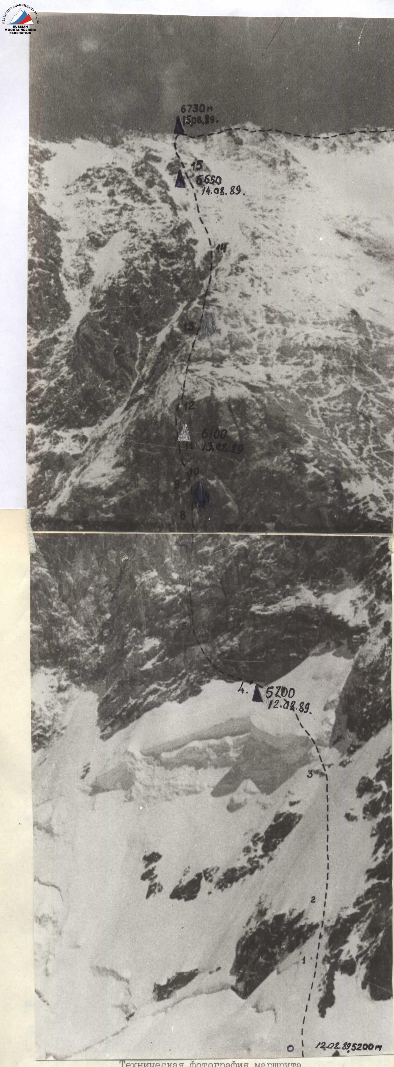
Brief geographical and sports characteristics of the ascent area
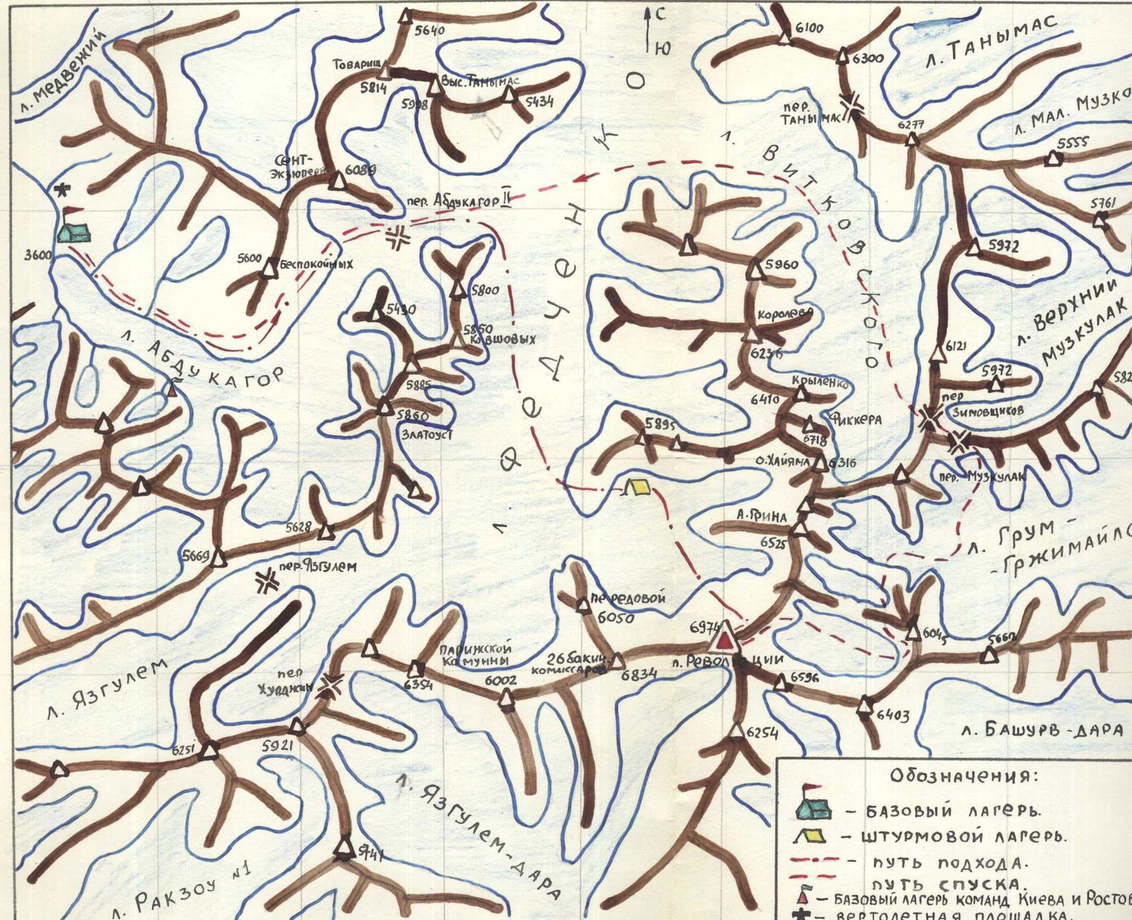
Peak named after Oktyabrskaya Revolyutsiya is located in the upper reaches of the Fedchenko Glacier, in the Yazgulem Range. The inaccessibility of the area poses significant organizational difficulties when conducting an expedition, even with the use of aviation. The considerable height of the upper reaches of the glacier (~ 5300 m) does not allow helicopters to land there, so the nearest place for a base camp when ascending Peak Revolyutsiya from the north should be considered the Vanch River valley (Abdukagor Glacier).
To approach Peak Revolyutsiya, it is necessary to:
- cross the Akademiya Nauk Range;
- overcome the Abdukagor II pass.
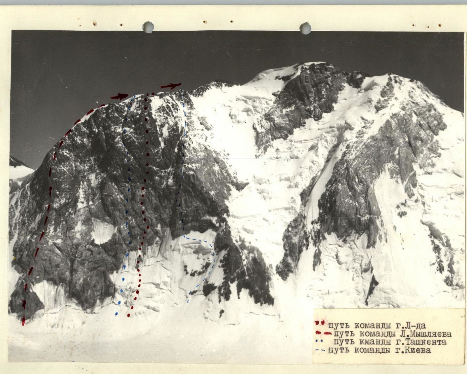
All of the above determined that the first mountaineering expedition, which successfully solved the task of conquering Peak Revolyutsiya via the north face under the leadership of the talented athlete L. Myshlyaev, appeared here only in 1962 (Peak Revolyutsiya was first conquered in 1954 from the Grum-Grжимайло Glacier). The ascent of L. Myshlyaev's top-class team made it possible to establish that the face belongs to the very complex category of difficulty, so for the next few years, no one thought about laying a new route. Only five years later, army and Chelyabinsk mountaineers decided to repeat L. Myshlyaev's route.
In recent years, Soviet high-altitude mountaineering has made significant progress. Now, no one talks about "impassable" or "problematic" faces; it has become clear that with proper preparation and organization, any high-altitude face can be climbed. The north face of Peak Revolyutsiya again attracted attention. Four teams out of seven entered it in the USSR championship this season.
For our team, this was the second entry. In 1974, the north face of Peak Revolyutsiya was entered by us in the USSR championship, but organizational difficulties did not allow the expedition to take place in this area.
Three teams arrived at the same time in Dushanbe, Vanch, and then at the Abdukagor Glacier (Taganrog — Rostov, Kiev, Leningrad).
The Taganrog — Rostov and Kiev expeditions decided to choose a location for the base camp on the left side (orographically) of the Abdukagor Glacier near a small lake (see map). However, there are no helicopter landing sites there, so all cargo was dropped. The Rostov team prepared well for this option, packing cargo into special barrels that withstood the drop well. The Kiev team faced difficulties.
We did not consider the drop option, so we immediately decided to organize the base camp at the tongue of the Abdukagor Glacier, near (300 m) a good helicopter landing site. The height of the base camp is 3600 m.
Subsequent work of the expedition showed that the choice of location was optimal:
- additional time for ascent to the Abdukagor pass did not exceed 1 hour;
- we were able to devote time to sports work immediately after arrival;
- the departure issue was resolved easily, while other expeditions had to organize numerous "shuttles."
The Tashkent team arrived in the area on July 21-22 by helicopter, which landed slightly above the lake.
The team conducted a training camp under Peak Lenin. On July 21, in the presence of Sports Committee representative N.M. Solovtsev, the issue of distributing routes on the north face of Peak Revolyutsiya was resolved.
The Leningrad team "received their route without competitive bidding." The issue between the Taganrog — Rostov and Kiev teams, which designated almost the same route, was resolved by drawing lots, resulting in the Rostov team getting the right to start the ascent first.
The Tashkent team was not ready to participate in the distribution of routes at the time of the meeting due to incomplete arrival, so their path on the photo was not indicated.
As a backup option, the Kiev team considered ascending to the right of our route along the rightmost combined buttress, so a boundary line was drawn to the right of our path on the photo, which should not be crossed due to safety conditions.
Sports Committee representative N.M. Solovtsev was given our plan for passing the route with a time calculation for two team size options: 5 and 9 people. The estimate matched the actual time of passing the route quite well, although it is difficult to account for many factors in advance.
Preparatory operations, acclimatization and reconnaissance exits, considerations on the tactical plan for passing the route:
To facilitate subsequent training and acclimatization exits to the plateau under Peak Revolyutsiya's face, a drop of food, gasoline, and equipment was made from a helicopter (~ 200 kg).
The first training and acclimatization exit to Peak Revolyutsiya was made from July 9-11. A storm camp was organized, a tent was set up on the plateau under the face (~ 5300 m), and the condition of the cargo dropped from the helicopter was checked. After one night on the plateau under Peak Revolyutsiya, the group returned to the base camp. Additionally, food and equipment were brought to the plateau. The first acquaintance with the face was made, and route options were reviewed.
The second training and acclimatization exit was longer (July 14-20), with the goal of:
- familiarizing ourselves with the proposed route in detail;
- clarifying the face's regime;
- assessing possible bivouac locations;
- determining the arsenal of necessary equipment;
- adjusting the expected timing of the route;
- making training ascents to peaks 5900-6100 m.
The set goals were achieved. Climbs were made to Peak Molodykh Vysotnikov 5900 m, from the summit of which and during the ascent to which it is convenient to observe the north face of Peak Revolyutsiya, and to Peak Peredovoy (6100 m). During the second exit to the storm camp, additional food and equipment were brought.
The participants' well-being was excellent, as could be judged by the daily transitions — base camp to storm camp, which the team made.
It was especially necessary to consider the tactical issues of organizing the ascent. First of all, an assessment was made of the rockfall hazard of the proposed ascent route through visual observation and listening. The analysis showed that the face "behaves" quite calmly, with few stones falling on their own.
This circumstance allowed:
- considering the possibility of increasing the group size to 9 people;
- going for longer route completion times.
However, in this case, the organization of the ascent became significantly more complicated, as a preliminary review of the face indicated difficulties in organizing bivouacs. This was later confirmed.
The assessment of the route's sun exposure was important. Overall, the wall section of the path, especially the lower 2/3, is exposed to the sun after 12:00 PM and until sunset. This circumstance allowed us to assume that under good weather conditions, the temperature regime of the face would be favorable, and work should start around 10:00-11:00 AM.
In case of bad weather, it was expected that there would be significant cold on the face, so it was necessary to take:
- the required number of warm clothes;
- gasoline.
This was done.
The main option for ascent was determined to be the hanging of ropes by the first "duo," as this is, in our opinion, the most rational method of movement on such a route with a backpack. It was also decided in advance to avoid pulling backpacks, as this operation:
- is not safe;
- requires time and effort.
When using good jumar clamps, this task is solved faster and easier. This was also implemented on the route. It was difficult to assess the strength of the rock face in advance, but based on available information, it was assumed that the rock should be destroyed. The set of pitons was diverse, and not much hope was placed on chocks. The assumptions were largely confirmed. Longer (70-80 mm) pitons provided greater reliability, although finding places for them was not easy.
The route is practically rock, so after passing the lower ice slope, it was decided to drop:
- crampons (except for two pairs);
- most ice pitons.
The first bivouac was decided to be set up in the bergschrund under a rock island, from where the processing of the route would continue, so the team's ascent to this bivouac was divided into two stages:
- first day — 4 people;
- second day — 5 people.
There was no point in ascending all participants simultaneously, as further processing required a lot of time.
During the ascent, an unforeseen difficulty arose, requiring adjustments and additions to the tactical plan. The sheer section of the face R14-R15 (see table) turned out to have a large number of "live," loose big stones, making it very dangerous for those below. The only correct decision was made — after processing, to pass this section on the hung ropes one by one. Tents were set up to the left of the ascent path (see photo) for safety. Naturally, this decision required significantly more time. On average, it took 2 hours 30 minutes to ascend one person, so the delay on the route was 1.5-2 days. Even with a smaller group, it is recommended to pass this section in this way, as an accident is almost inevitable in case of falling stones. It was also necessary to assess the descent paths from the summit; several were considered:
- descent from the ridge between Peak Revolyutsiya and Peak Gрина towards the storm camp, possible in good weather;
- descent via L. Myshlyaev's route, technically complex;
- descent to the east via A. Ugarov's route (first ascenders).
After analysis, the first option was chosen as the main descent route. At the end of the ascent, another descent option arose — via the route of the Kiev group's ascent, as we had the opportunity to familiarize ourselves with this path during the ascent. After height 6200 m, the route is not difficult, allowing for fast and simultaneous movement. At the same time, this descent option is also suitable only for good weather.
Description of the ascent
On July 25, the "four" — Borzov Yu., Lazarev V., Shalygin Yu., Eltyshev A. — ascended the ice slope to begin processing the rock part of the face. It was also necessary to assess the reliability of radio communication between the storm camp and the face. The ascent took 4 hours. A good bivouac was organized in the bergschrund.
On July 26, the remaining team members also approached the bivouac, while processing of the route continued above.
July 27 — August 4. Passage of the face. The necessary information is contained in the table of main characteristics.
It is worth noting several general points during the passage of the route:
- The route can be conditionally divided into three parts: the lower — an ice slope of medium difficulty (4-5 category of difficulty), the middle — a rock face of the highest (6 category of difficulty) category of difficulty (up to section R15-R16), the upper — a rock buttress, complex (5B category of difficulty).
- There was no spontaneous stonefall observed on the route.
- Movement was carried out almost everywhere on fixed ropes.
- At the end of each working day, during the preparation of bivouac sites, processing continued above.
- The team tried to maintain a uniform daily schedule.
- All driven pitons were used for belaying; on average, half were used for artificial holds on sections of 6 category of difficulty.
- "Duo"s alternated in various combinations, with participants working first.
- Bivouacs were mostly poor, as it was difficult to create platforms due to the steepness of the face. There were no ready-made bivouac sites, i.e., those not requiring significant construction work.
- Under favorable weather conditions (such as during our ascent), it is warm on the face, even during bivouacs without tents, up to the very summit ridge.
- Comparison of our route with other routes on the north face indicates the following (confirmed by photographs):
- the route is logical, separated on the face to the right and left from possible paths by deep couloirs;
- the most steep (rock part), as shown with the help of photos and diagrams;
- more saturated with technically complex sections.
On August 5, the weather is still bad, and there is no reason to believe it will improve, so we decide to start descending, with the intermediate goal of reaching a small plateau between Peak Revolyutsiya and Peak Gрина.
First, we began descending down the ridge (L. Myshlyaev's route); after 20 minutes, we reach the tent of the Putinchev A. group's team. They also descended from the face to the ridge late on August 3, so on August 4, when we were on the summit, they were resting.
The Tashkent team is preparing to ascend to the summit; in such weather, it will be difficult to "find" it, and we, during one of the gusts of wind that dispersed the veil of snow and fog, manage to see the descent path to the plateau under peak 6300. The descent turned out to be simple, and after 1 hour, we are already at a height of 6000 m. However, we cannot descend further due to:
- extremely strong wind;
- complete lack of visibility.
We decide to bivouac, assuming that the weather will improve early in the morning. The wind tears at the tents all night.
August 6. In the morning, the weather has not improved. After waiting until 12:00 PM, we begin organizing the descent towards Peak Gрина. Visibility is 3-4 m, strong wind, snow. 250 m of ropes are hung, which are enough to reach the plateau. By the time the last team member descends, the A. Putinchev group catches up with us. We decide to leave the ropes for them, which they will remove tomorrow.
We bivouac on the plateau, height 5700-5800 m.
August 7. The weather has not changed. We wait for the A. Putincev group to descend so that, having received the ropes, we can begin organizing the descent to the Grum-Grжимайло Glacier. In such weather conditions, this descent option seems most correct for the subsequent crossing. The Tashkent team catches up with us; they join our decision but are very concerned that there has been no radio contact with observers for 3 days due to a faulty radio station. Using our radio station, we transmit a message to the observers' camp about completing the ascent and starting a tourist hike through:
- Zimovskikh pass;
- Vитковского Glacier;
- Fedchenko Glacier;
- Abdukagor pass.
We bivouac together on the Grum-Grжимайло Glacier, height 5300-5400 m.
August 8. The weather has not improved, although, considering the loss of height, it is very cold. The area maps are approximate, so we begin descending along the glacier, observing the direction of the ridges from the main range (Peak Revolyutsiya — Peak Gрина — Peak Khayyam — Peak Fikker).
We successfully find the ascent to, in our opinion, the Zimovskikh pass. However, it turns out that we are slightly mistaken (by 500-700 m) and exit onto the Muzkulyak pass. The Zimovskikh pass is nearby, and it is possible to simply move to it; however, the group ahead (6 people), not noticing the mistake and believing they are already on the Vитковского Glacier, begins descending. It is impossible to catch up with the group, so the only possible solution is to hope that they will notice their mistake and return. We bivouac on the pass (~ 5800 m).
August 9. We decide to attempt to catch up with the group in the morning (a permissible attempt), but it is not successful. There is not much concern about the group's fate, considering its:
- size (6 people);
- participants' qualifications;
- equipment;
- absence of technical difficulties on their path.
We leave food for the group in a cairn on the pass and continue down the Vитковского Glacier with the Tashkent team.
On August 10, early in the morning, we meet the observers. It remains to wait for the lost part of our team, which, as later выяснилось, noticed their mistake only on the second day of descent, having traveled a significant distance and descended from the icefall. They decided to:
- reach the village of Kudara;
- send a telegram;
- return to the Vanch valley by car.
The telegram was sent on August 13, but it was not delivered on time. On August 16, the team leadership decided to fly to Kudara by helicopter, but this was not necessary, as on the 17th, early in the morning, everyone returned safely to Vanch.
Captain, team coach
G.A. Chunovkin.
Table
of the main characteristics of the ascent route to Peak named after Oktyabrskaya Revolyutsiya (6974 m) via the north face
Route length (face) 2110 m
Height difference 1450 m
Length of the most complex sections (6 category of difficulty) 530 m
Average steepness 70-75 degrees
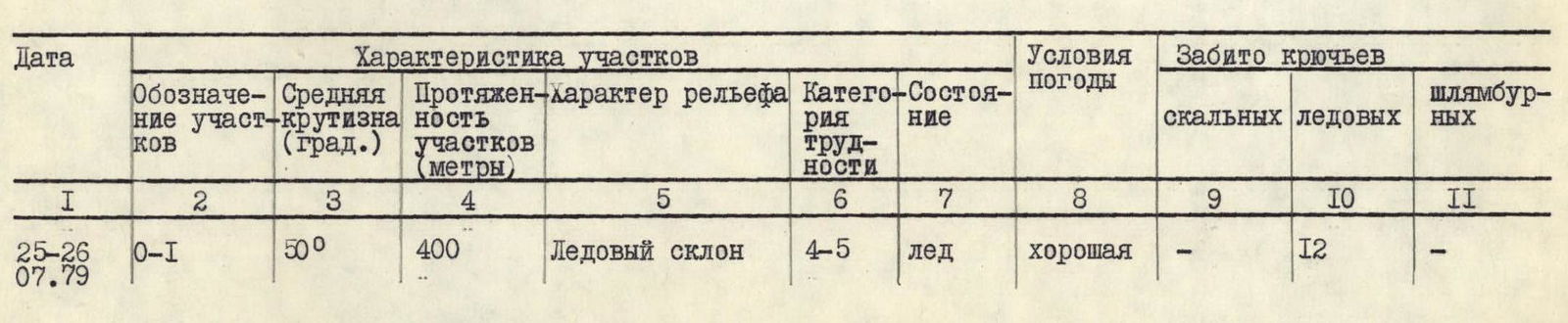
| Date | Designation of sections | Average steepness (degrees) | Length of sections (m) | Relief characteristics | Category of difficulty | Condition | Weather conditions | Number of rock pitons driven | Number of ice pitons driven | Number of pitons driven (bolts) |
|---|---|---|---|---|---|---|---|---|---|---|
| July 25-26 | R0-R1 | 50° | 400 m | Ice slope | 4-5 | ice | good | – | 12 | – |
| R2-R3 | 55 | 40 m | Ice "ridge" | 5 | ice | good | 8 | – | – | |
| R3-R4 | 60 | 90 m | Rocks, местами лёд на скалах | 5 | rocks | –"– | 11 | – | – | |
| R4-R5 | 90 | 40 m | Rocks, traverse right-up | 6 | rocks | –"– | 6 | – | – | |
| R5-R6 | 65 | 100 m | Rocks, inner corner, ascent left-up | 6 | rocks | 22 |
Ascent to the route at 11:00 from bivouacs on the slopes of Peak Molodykh Vysotnikov (the glacier is crossed in 1 hour), stop at bivouac at 17:00. Total time of walking hours on the route — 5 hours. Bivouac is convenient, protected, lying in the bergschrund.
Processing of the face. Ascent to the route at 11:00, end of work at 20:00 (time spent 9 hours, worked by a "duo"). Bivouac at the same place in the bergschrund.

| July 28 | R1-R2 | 65 | 80 m | Rock "island" | 5 | rocks | good | 8 | – | – |
|---|---|---|---|---|---|---|---|---|---|---|
| July 29 | R6-R7 | 80 | 20 m | Rocks, wall, traverse along left | 6 | rocks | good | 4 | – | – |
| R7-R8 | 85 | 70 m | Wall, rocks | 6 | rocks | –"– | 12 | – | – | |
| R8-R9 | 70 | 60 m | Wall, wide crack | 6 | rocks | –"– | 10 | – | – |
Ascent to the route at 9:30, stop at bivouac (section R5-R6) at 19:30. Walking hours 10 hours. Bivouac is sitting, distance between tents 40 m.
Ascent to the route at 10:00, stop at bivouac (section R8-R9 — 7 people; section — 2 people) at 21:00. Walking hours 11 hours. Bivouac is sitting for 7 people, hanging for 2 people. Distance between groups 100 m.
| July 30 | R9-R10 | 65 | 30 m | Smooth, "polished" rocks типа "бараньих лбов" | 5 | rocks | good | 4 | – | – |
|---|---|---|---|---|---|---|---|---|---|---|
| R10-R11 | 80 | 120 m | Wall, 30-meter chimney in the middle | 6 | rocks | –"– | 21 | – | – | |
| R11-R12 | 70 | 80 m | Inclined inner corner, direction right-left | 5 | rocks | –"– | 8 | – | – | |
| R12-R13 | 65 | 80 m | Icy rocks | 5 | rocks | –"– | 7 | – | – |
Ascent to the route at 10:30, stop at bivouac at 19:00. Walking hours 8 hours 30 minutes. Bivouac is semi-reclining: 5 people together, 4 separately — one by one, close to each other.
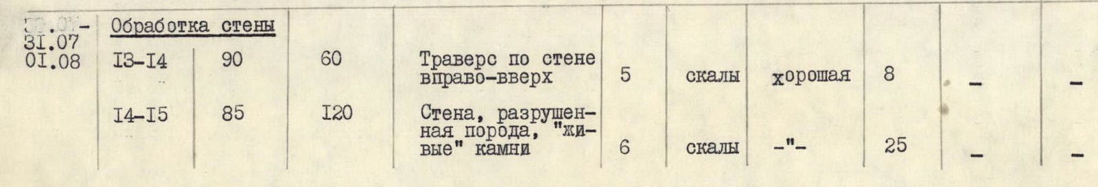
| July 31 – August 1 | R13-R14 | 90 | 60 m | Traverse along the wall right-up | 5 | rocks | good | 8 | – | – |
|---|---|---|---|---|---|---|---|---|---|---|
| R14-R15 | 85 | 120 m | Wall, destroyed rock, "live" stones | 6 | rocks | –"– | 25 | – | – | |
| R15-R16 | 80 | 20 m | Wall, traverse up-right | 5 | rocks | good | 3 | – | – |
Ascent to the route at 10:00. Managed to pass the wall up to 21:00 — 6 people. The "triplet" bivouacked at the previous location. Bivouac for 6 people in two places is semi-reclining: 4 and 2.
| August 2 | R16-R17 | 70 | 120 m | Wide inner corner | 5 | rocks | good | 15 | – | – |
Ascent to the route by the "triplet" from the lower bivouacs at 10:00, to processing section R16-R17 at 12:00. Everyone gathered at the bivouac at 20:00. Bivouac in two places: 4 and 5 people. Bivouac is lying after construction work.
| August 3 | R17-R18 | 80 | 160 m | Wall, wide crack in the center | 5 | rocks | good | 18 | ||
|---|---|---|---|---|---|---|---|---|---|---|
| R18-R19 | 70 | 320 m | Wide buttress | 5 | rocks | –"– | 35 | |||
| R19-R20 | 65 | 100 m | Snowy rocks | 5 | rocks | –"– | 8 |
Ascent to the route at 10:30, stop at bivouac at 19:00. Walking hours 8 hours 30 minutes. Bivouac is lying, good, on the ridge.
| August 4 | R20-R21 | 20-25 | 650 m | Summit ridge | 3 | snow, ice, rocks | strong wind, snow, lack of visibility | 1 | – | – |