PAMIR. Upper reaches of the Fedchenko Glacier. Peak: Korolyov S.P. 6236 m, from the Sredniy Glacier along the Western ridge, combined.
Description of the first ascent made on August 14, 1968 by a group of climbers from the Chelyabinsk Regional Council of the ZENIT Voluntary Sports Society (DSS). Leader: A. Vakhmenin.
The description was compiled by A. Vakhmenin
Chelyabinsk Regional Federation of Alpinism. — 1968.
CENTRAL PAMIR. Scheme of the ridges of the upper reaches of the Fedchenko Glacier.
I. Introduction
Peak 6236 m is located in the northern part of the ridge of the South Group of the Fedchenko Glacier (see map-diagram). The ridge of the South Group of the Fedchenko Glacier separates the Fedchenko Glacier and the Vitkovsky Glacier, starts approximately opposite the Abdukagor-1 pass, and initially stretches east, and after the peak 6236 m — south.
The ridge contains, starting from the northern part:
- peak 5360 m,
- peak 5960 m,
- peak 6236 m,
- Peak Krylenko,
- Peak Fickler (photo 2).
To the west of Peak Krylenko, a lateral spur adjoins with three peaks. The closest one to Peak Krylenko was conquered by a group led by G. Yazovskikh in 1967 and was named Peak Vasiliev (6000 m).
Between the aforementioned spur and the massif of peaks 5960 m and 6236 m lies the Sredniy Glacier, which flows into the Fedchenko Glacier (photo 2).
The group was aware of an attempted reconnaissance of the route to peak 6236 m made in 1962 by a high-altitude expedition group from the CS DSS "Burevestnik", which ended tragically.
Our preliminary reconnaissance on July 29, 1968 (A. Vakhmenin — V. Davydenko) reinforced the opinion about the possibility of ascending to peak 6236 m from the Sredniy Glacier. After a more detailed study conducted during the ascent to the neighboring peak to the west — peak 5960 m via the most convenient reconnaissance route (3A category of difficulty), a logical, feasible, and most importantly, safe route along the Western ridge to peak 6236 m was planned (photos 3, 4).
II. General characteristics of the route
The route consists of the following main stages:
- Approach from the base camp "4300" to the assault camp on the Sredniy Glacier (sh/l Sredniy).
- Ascent from sh/l Sredniy to the ridge between peak 5960 and peak 6236.
- Ascent along a snow-ice slope with outcrops of destroyed rocks to a depression under the ridge.
- Ascent from the depression along a rocky wall to the ridge.
- Ridge section — relatively gentle, narrow, corniced ridge with "gendarmeries" and snow-ice ascents of varying length and steepness.
- Pre-summit ascent — slope with a vertical section line: to the south — rocks, to the north — snow. Height 120–150 m. Slope — upon exiting the Western ridge at the bottom 40–50° with a gradual, smooth (10–15°) ascent to the pre-summit rocks.
- Summit. A snow dome crowns the pre-summit rocks, ending in a sheer face towards the Vitkovsky Glacier. Height about 20 m above the pre-summit rocks, 60–80 m to the east of them.
- Descent from the summit to sh/l Sredniy via the ascent route.
- Return from sh/l Sredniy to b/l 4300.
III. Technical description
The base camp "4300" is located on the moraine below the Abdukagor-1 pass (4–6 hours walk to the pass). The path from b/l "4300" goes along the moraines, then diagonally through the ice fall, to a "hitch" , and further along the heavily crevassed glacier. Movement is in teams. A long and gentle ascent leads to the pass. The pass has a convenient bivouac site. An intermediate assault camp "Pass" is set up here.
From here, a gentle descent leads to the Fedchenko Glacier along the massif of Peak Kovshevykh, about 800–900 meters, then crosses the Fedchenko Glacier (width in this area is 2–3 km), and enters the cirque of the Sredniy Glacier. The slope of the glacier is 10–15°. Many crevasses are filled with water. Movement is in teams. Ahead, Peak Krylenko is visible.
In the upper reaches of the glacier, about 1 km before Peak Krylenko, opposite a pronounced depression between peak 5960 and peak 6236, an assault camp "Sredniy" is set up (5200 m).
From the camp, only the beginning of the route is well visible (path along the slope — photo 3). However, its upper section, as well as the ridge part of the route, appears superimposed, which does not give a true representation of the path's nature.
From sh/l "Sredniy", ascent is made along a snowy slope between two rocky outcrops (photo 3), and in some places along rocks (since exposed ice hinders movement). The slope, with a steepness of 45–50°, is covered with shallow (20–30 cm) snow, and in some places with calga-spora.
Rocks are heavily destroyed, and in some places are slab-like.
Movement is in teams, with step-cutting when emerging onto exposed ice.
A little above the middle of the slope, the rocky outcrops end. Movement continues along steep snow (1–1.5 ropes), then along a snowy corniced ridge (slope inflection). The ridge gradually becomes less steep, ending in a bend. The height gain along the slope is 600–700 m. From the bend, there is a descent into a small depression along a snowy slope of 15–20° to a depth of 10–15 m, then into a larger depression along a slope of 50–60° to a depth of 25–30 m (photo 1). Snow is deep and dense. Belay is done through an ice axe.
The path from the depression is diagonally across a rocky, sheer wall (70–80°). Rocks are complex, snow-covered, with good protrusions. Height is 15–20 m. 3 hooks are hammered in (photo 5).
The wall leads to the ridge, which at this point is a flat area 35–40 m wide and 50–60 m long. A very convenient place for an overnight stay.
Time taken to move from sh/l "Sredniy" to the ridge: 3–3.5 hours.
From the area (in the direction of movement towards the summit), the ridge begins with a wide snowy slope of 40–50° steepness, 280–300 m long, transitioning upwards into a more narrow ice slope, ending in rocks (photo 4). This narrow ridge does not widen further. Cornices adjacent to its "gendarmeries" overhang both to the north and south. Height differences between "gendarmeries" range from 10 to 50 m.
Alternating movement from the area behind the wall to the pre-summit ascent: 2–3 hours.
The most difficult sections are three:
- An inner corner formed by two smooth stone slabs 10–12 m long, with a steepness of 35–40°. There is no bypass to the right or left — sheer faces. Passage is through the corner. 2 hooks are hammered in.
- A horizontal stone "knife" — a rocky ridge 5–6 m long with smooth edges. Movement is done sitting astride with careful belay to protrusions on both sides of the "knife".
- Ascent along a couloir with a steepness of 25–30°, 30–35 m long, along medium rocks. The couloir ends in a vertical slab (70–80°). Passage is along the right side of the slab on a 3 m long ledge. A duralumin wedge is hammered in. After passing the slab, there is a descent of 10–12 m onto the ridge, which leads to the pre-summit ascent via a narrow snowy "knife" with a large cornice, which abuts the snowy side of the ascent. To the south, towards the Sredniy Glacier, a steep ice couloir descends at this point.
Carefully traversing the couloir to the right along the slope (photo 6), we emerge onto rocks. Difficult climbing of 10–15 m (two hooks) along an inner corner above a sheer face to a ledge. Then movement is alternating upwards along the slope beside rocks. Initially, the slope steepness is up to 50°, then it becomes less steep and leads to pre-summit rocky outcrops, where a cairn is built by the group (photos 7, 8). Time taken to pass the pre-summit ascent is 1.5–2 hours, height gain is about 150 m.
From the cairn to the highest point of peak 6236, it is 60–80 m east across the snow dome. Height gain is not more than 20 m.
No cairn or any other signs of human presence were found on the rocky outcrops.
Near the rocks, in a shallow snowy depression, an overnight stay is possible.
Descent is made along the ascent route. At the end of the pre-summit ascent, a rope descent (40 m) is organized onto the ridge to the point where the couloir is traversed (2 hooks are hammered in). Descent from the ridge into the larger depression is made along a rope. 4 hooks are hammered in: 2 for descent and 2 for belaying the last person. Time taken to descend from the summit to sh/l "Sredniy": 5–6 hours.
The group's passage of the route was completed in 1 day and took 13 hours. The group had down-filled gear and a tent, which was set up on the ridge area.
The ascent took place in complex weather conditions. In the morning, it was clear. During the passage of the ridge, there was wind and snow — visibility was no more than 20–30 meters. At the summit, visibility was up to 10 m, sometimes clearing to 20 m. Then, upon returning to the tent, snow squalls ceased, and the group, removing the tent, descended to the camp.
A successful ascent in such complex weather conditions was made possible by the reconnaissance conducted by the group a day earlier in good weather during the ascent to the neighboring peak 5960 m.
IV. Recommendations for the route
- The assault camp should be located on the Sredniy Glacier within a 15–20 minute walk from the slope — this allows for an early start on the route and passage along the slope on firm snow.
- The entire group should wear crampons.
- Recommended footwear — crampons or felt boots with crampons (crampons hold well on rocks).
- Main ropes — 40 meters long.
- Hooks: ice — 3 pcs. rock — 7 pcs. wedges — 2 pcs.
Leader of the ascent: A. Vakhmenin.
V. Group composition
The first ascent was made by a group from the Miass Alpine Club consisting of:
- Vakhmenin A.S. — leader, 2nd sports category, DSS "Zenit"
- Tonkov V.V. — participant
- Ponkina T.N.
- Butkov V.L.
The group operated as part of the alpinad of the Chelyabinsk Regional Council of DSS "Zenit", working in the upper reaches of the Fedchenko Glacier from July 22 to August 27, 1968.
The group was cleared for the route on August 11, 1968.
VI. Proposals for naming the peak
As the first ascenders, the group proposes naming the unnamed peak 6236 m after SERGEI PAVLOVICH KOROLYOV, a prominent designer of rocket and space systems, member of the Presidium of the USSR Academy of Sciences, communist, twice Hero of Socialist Labor, Lenin Prize laureate, and academician. S.P. Korolyov was born on December 30, 1906, in Zhytomyr, in the family of a teacher. Since 1927, he worked in the aviation industry. In 1930, he graduated from the Bauman Moscow Higher Technical School faculty and in the same year from the Moscow School of Pilots.
In 1932, with his participation, the Group for the Study of Reactive Motion was organized, whose team created the first experimental rockets. S.P. Korolyov's further work was associated with the creation of rocket and space systems, on which the world's first artificial Earth satellites were launched, pennants were delivered to the Moon, and the far side of the Moon was flown over and photographed. The manned spacecraft created under his leadership, on which a person first flew into space and performed a spacewalk, opened a new era in the history of Earth.
S.P. Korolyov's tireless energy, talent as a research scientist, excellent engineering intuition, and great creative courage in solving complex scientific and technical problems were combined with outstanding organizational abilities and high moral qualities.
We want one of the mountain peaks of the Central Pamir to constantly remind us of the man who turned humanity's dreams, ideas, and ideals about space into metal.
VII. Conclusion
The group evaluates the route taken to peak 6236 m (Peak Korolyov), combined, from the Sredniy Glacier along the Western ridge, as corresponding to category 4B difficulty and petitions the Alpinism Federation of the USSR to include it in the All-Union classification of peaks.
Confirmation
regarding the assessment of the route's difficulty category.
A group of the alpinad of the Chelyabinsk Regional Council of DSS "ZENIT" consisting of: Silchenko S. — leader, and participants:
- Konev V. — 2nd sports category in alpinism
- Oparin I. — 2nd sports category
- Tamplon V. — CMS
Having completed the ascent to peak 6236 m via the route of the first ascenders (Vakhmenin A.'s group), join the opinion of the first ascenders regarding the assessment of the route's difficulty as 4B.
The route is comparable to classified routes of ascent to the peaks:
- Issyk-Kul Peria (4B category of difficulty)
- Brigantina (5A category of difficulty)
Karakolsky Ridge area, Tian Shan.
Group leader: S. Silchenko
Participant: V. Tamplon
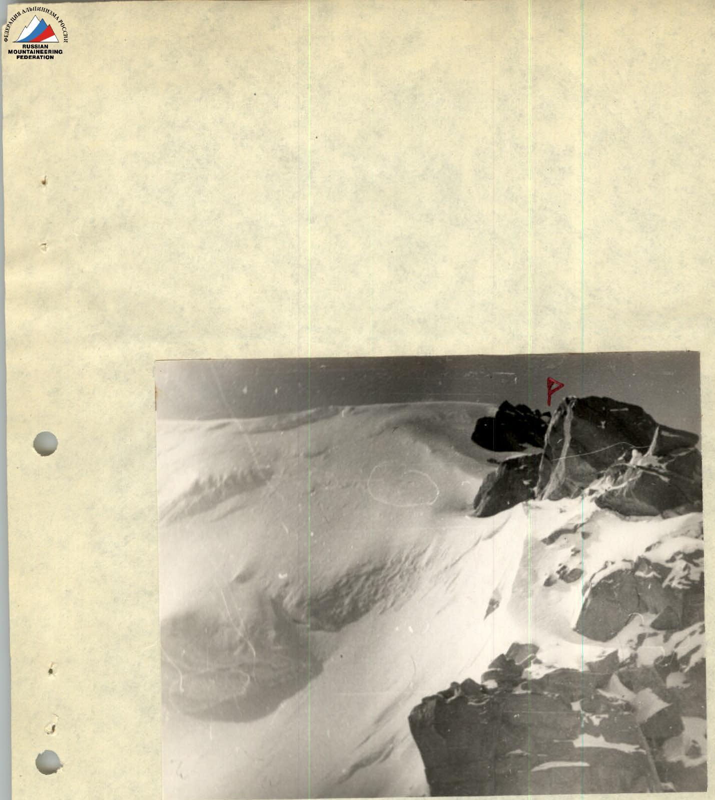
Photo 7. Exit to the summit. The location of the cairn is indicated. (author A.S. Vakhmenin)
Table of main characteristics
Ascent route: Peak Korolyov (peak 6236 m) from the Sredniy Glacier along the Western ridge, combined.
Route height difference: 1036 m (5200–6236 m), including complex sections: rocky — , snowy — .
Average steepness of the route: , including complex sections: rocky — 70°, snowy — 45°.
Date: August 14, 1968. Weather conditions: wind, snow, poor visibility.
Time: departure from sh/l "Sredniy" — 6:00, return — 19:00, moving hours 11–12.
| Section # | Average steepness | Length | Section level and conditions for overcoming | Hooks hammered in | Note |
|---|---|---|---|---|---|
| Relief | Tech. difficulty | Method of overcoming | |||
| 1 | 15° | 6 km | gentle ice-snow slope, ridge | easy and medium | in teams, crampons |
| 2 | 5° | 5 km | deep snow, ice | easy | in teams |
| 3 | 47° | 740 m | snow, ice, rocky outcrops | medium | crampons, ice axe, protrusions |
| 4 | 25° | 140 m | deep snow | difficult | ice axe |
| 5 | 15° | 50 m | deep snow | medium | in teams |
| 6 | 75° | 20 m | snow-covered rocks | difficult | protrusions, hooks |
| 7 | 45–40° | 300 m | snow, ice, rocky outcrops | medium | protrusions, ice axe, hooks, crampons |
| 8 | 500 m | snow-covered rocky ridge, cornices, ice | medium | protrusions, hooks, crampons, ice axe | |
| 9 | 75° | 12 m | snow-covered smooth rocks | difficult | hooks |
| 10 | 6 m | snow-covered smooth rocks | difficult | protrusions | |
| 11 | 35° | 35 m | snow-covered rocks | difficult | hooks, protrusions |
| 12 | 50° | 15 m | snow-covered rocky ridge, loose, deep snow | medium, difficult | protrusions, ice axe, hooks |
| 13 | 15° | 100 m | deep snow | easy | in teams |
Total number of hooks hammered in during ascent: rock 7, 1 wedge, ice 1.
Leader of the first ascent: A. Vakhmenin.