Peak BOLGARIA (5666 m) via peak 5600 along the Western Ridge (Central Pamir)
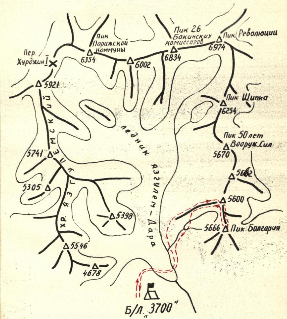
Area Map
Geographical Location
The gathering place for the climbers of MOS DSO "Zenit" in 1970 was the area of Peak Revolyutsii in the Central Pamir, with the base camp located in the upper reaches of the Yazgulem-Dara valley.
The summit — Peak Bolgariya — was the target of the ascent. It belongs to the mountain chain stretching south from the highest peak in the area — Peak Revolyutsii (6974 m).
On the opposite, western, side of the valley, the peaks of the Yazgulemsky Ridge stretch from north to south, most of which exceed 5000 m in height.
The area is dominated by six-thousander peaks located in the northern part of the valley:
- Peak Revolyutsii,
- Peak 26 Baku Commissars,
- Peak Paris Commune,
on whose southern slopes the Yazgulem-Dara glacier originates, and on the northern slopes — one of the largest glaciers in the world, the Fedchenko glacier.
Climbing Conditions
The remoteness (over 100 km) from large settlements and roads significantly complicates the organization of expeditions to this area.
Only in 1967 did the first mountaineering expedition of CSKA athletes arrive here.
The expedition obtained a lot of interesting data — photographs, aerial photographs; made first ascents to Peak Shipka along the western ridge, Peak Bolgariya, and others.
The area is characterized by a large altitude difference, up to 3 km or more, steep slopes, and the possibility of choosing the most complex ridge and wall routes that have not yet been climbed.
Climatic conditions are quite favorable. In the summer months — July, August — relatively stable, clear weather is observed. However, at an altitude of about 6000 m, the wind almost never subsides, reaching 10–15 m/s, and the temperature drops to –20 °C at night.
Preparation for the Ascent
The team of climbers from MOS DSO "Zenit" together with the combined team of CS DSO "Zenit" arrived in the district center Rushan on July 4. Delivery of goods and people to the base camp was carried out from the Rushan airfield by helicopter, which saved us from having to organize a slow and cumbersome caravan. On July 7, all work on organizing the base camp on a large flat green area near the tongue of the Yazgulem-Dara glacier, at an altitude of 3700 m, was completed.
Reconnaissance exits and training ascents were planned to:
- explore the largest possible area,
- choose the most interesting climbing routes.
In addition, training ascents provided an opportunity for athletes to acclimatize at high altitudes.
On July 9, the entire expedition made an exit to scout the path through the glacier and approaches to the peaks in the area of Peak Paris Commune, Peak Revolyutsii, and Peak Shipka.
Two days later, a group of 6 people, including all team members, went to the rocky massif ("Grebionka") in the ridge of peak 5600 on the opposite side of the valley from the camp. From here, from Grebionka (5100 m), the further path to peak 5600, located between peak 5682 and peak Bolgariya, was observed, as well as the previously unclimbed southwestern ridge of peak Shipka.
For the ascent to peak Bolgariya, the following team composition was approved:
| Efimov O.N. | 1st sports category | team leader |
| Korolkov B. | 1st sports category | participant |
| Vorobyov L.F. | 2nd sports category | participant |
| Pugachyov V.A. | 2nd sports category | participant |
Organization of the Ascent
Considering the specifics of the route — the presence of snow-ice and rocky sections, we selected, in addition to standard equipment:
- titanium rock (20 pcs.) and ice (4 screw and 6 piton) pitons;
- titanium crampons;
- protective helmets.
One high-altitude tent was taken for the group. The amount of food was calculated at 750 g of dry rations per person per day for 5 days on the route.
For communication with the base camp, a portable radio station was taken, and communication schedules were established:
- at 9:00 and 17:00 — scheduled communication;
- at 12:00 and 21:00 — emergency communication.
The control time for returning to the camp was set for July 20, 1953, at 18:00.
The entire route was divided into main sections, and bivouac locations were planned.
Day 1. On July 14, at 13:00, the group left the base camp "3700", crossed the Yazgulem-Dara glacier in its lower part, climbed to the left-bank moraine, and continued moving upwards, first along a grassy slope, and then along medium and large scree in the direction of the rocks of the western ridge of peak 5600 (section R0–R1 and R1–R2). We reached the ridge in two rope teams: Efimov – Vorobyov and Korolkov – Pugachyov. The rocks are heavily destroyed. We moved simultaneously, securing the rope to ledges and trying not to dislodge rocks. The upper part of the rocks is a series of rocky outcrops — "Grebionka". The rocks here are less destroyed and steeper. We reached a pass between the 1st and 2nd outcrops. The second outcrop was overcome along ledges to the right with occasional protection through ledges. We found a small area before the next rocky ascent and settled in for the night at 18:30.
Day 2. On July 15, at 9:00, we continued on the route. We moved with occasional protection through outcrops along rocks of medium difficulty, bypassing "gendarmeries" mainly to the right along ledges or by climbing. The last "gendarme" was overcome with piton protection (2 pitons). After passing a small snow col, we reached a "black" rocky wall, representing a ridge ascent, 120 m long with an average steepness of 60° (section R5–R6). Along snow and rock ledges (1 piton), we reached a chimney (60°, 60 m) covered with ice with rocks frozen into it (2 pitons) (section R6–R7). The chimney led to a wall (50°, 60 m) (section R7–R8) (2 pitons). Then, along a small snow patch, we approached a steep (80°), almost smooth slab, which we traversed by complex climbing to the right (1 piton) (section R8–R9). The final ascent of the wall (60°, 100 m) was overcome "head-on" (section R9–R10). At the top, on a small rocky area, we set up a bivouac at 17:00.
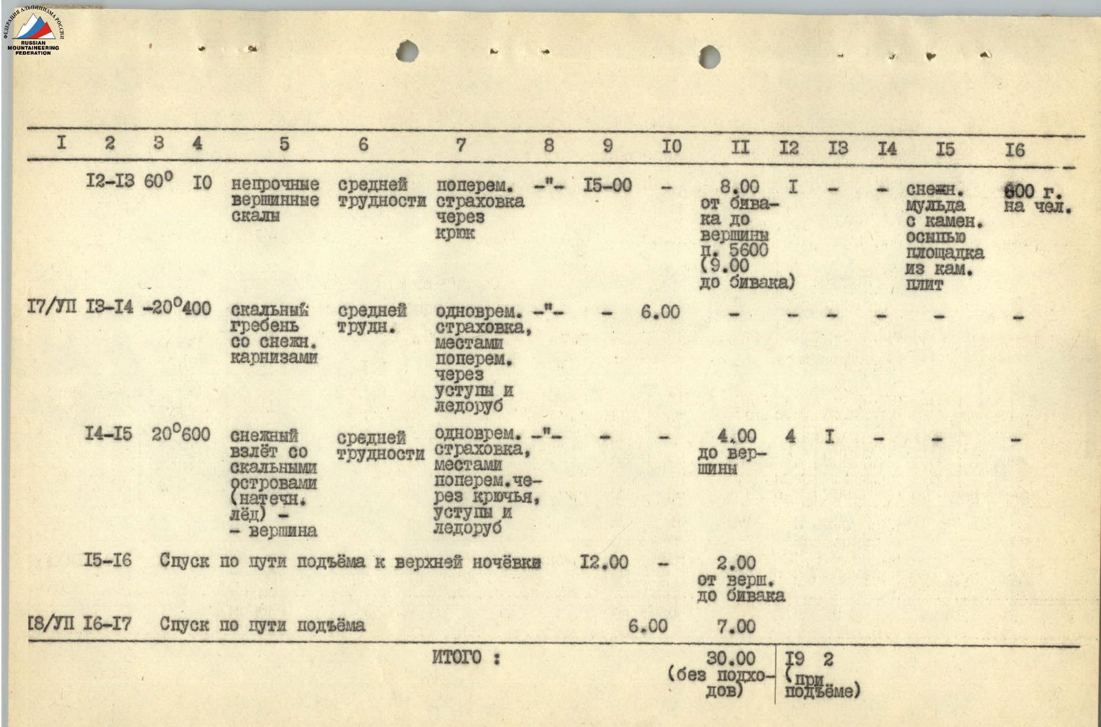
Day 3. On July 16, the group left on the route at 6:00. The path passed first along a snow-ice col (section R10–R11). The slope is steep in its upper part. We moved with occasional protection through an ice axe. The col led us to a snow ridge (160 m) (section R11–R12), so narrow that both feet couldn't fit, and the person in front had to carefully tread the top of the ridge. In the middle part, the ridge turned into a thin, overhanging cornice, which we had to bypass very carefully to the right, descending 2–3 m along a steep (60°) snow slope. Movement was occasional, with protection through an ice axe. The ridge abutted against the summit rocks, 8–10 m high (section R12–R13) (1 piton). At 14:00, the group reached the summit of peak 5600. We did not find a note. We built a cairn. We proposed naming the peak "Peak Nadezhda". From the summit, a jagged rocky ridge stretched towards peak Bolgariya (–20°, 400 m) (section R13–R14). To the left of the ridge, there were a number of deep snow-ice cols. In the first col, on a good area, we set up a bivouac at 15:00.
Day 4. On July 17, we left on the route at 6:00. After passing the ridge, we reached a gentle snow ascent leading to the summit (20°, 600 m) (section R14–R15). On the way, there were two rocky outcrops. The first — "ryжие скалы" (red rocks) — we bypassed to the right along the edge of the

Peak 5600 (view from Peak 5682).natёchnomu ice with careful piton protection (4 rock and 1 ice piton) and step-cutting.
The second section — "chёрные скалы" (black rocks): we passed by climbing "head-on" (8 m, 70°) with the cutting of a snow cornice in the upper part.
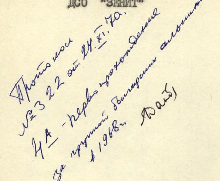
We reached the summit at 10:00. In the cairn, we found a note from climbers of CSKA and Bulgaria (1968). After replacing the note, we began our descent along the ascent path to the last night's bivouac. We reached the tents at 12:00.
Due to the danger of moving on the thawing snow, we decided to postpone the further descent until the next day. At night, the weather worsened, and it started snowing.
Day 5. On July 18, at 5:00, we were back on the route. We descended along the ascent path. At the transition from the "black" wall to the "grebionka", we turned left along the scree couloir. Then — along the glacier to the Yazgulem-Dara river. We returned to the camp at 17:00.
Overall Assessment of the Participants' Actions
All team members were well-prepared physically. Actions on the route were characterized by high reliability and the ability to navigate complex sections. Participants demonstrated good technique on:
- rocks,
- snow,
- ice.
The cohesive team composition allowed for an even and rational distribution of forces among participants on the route.
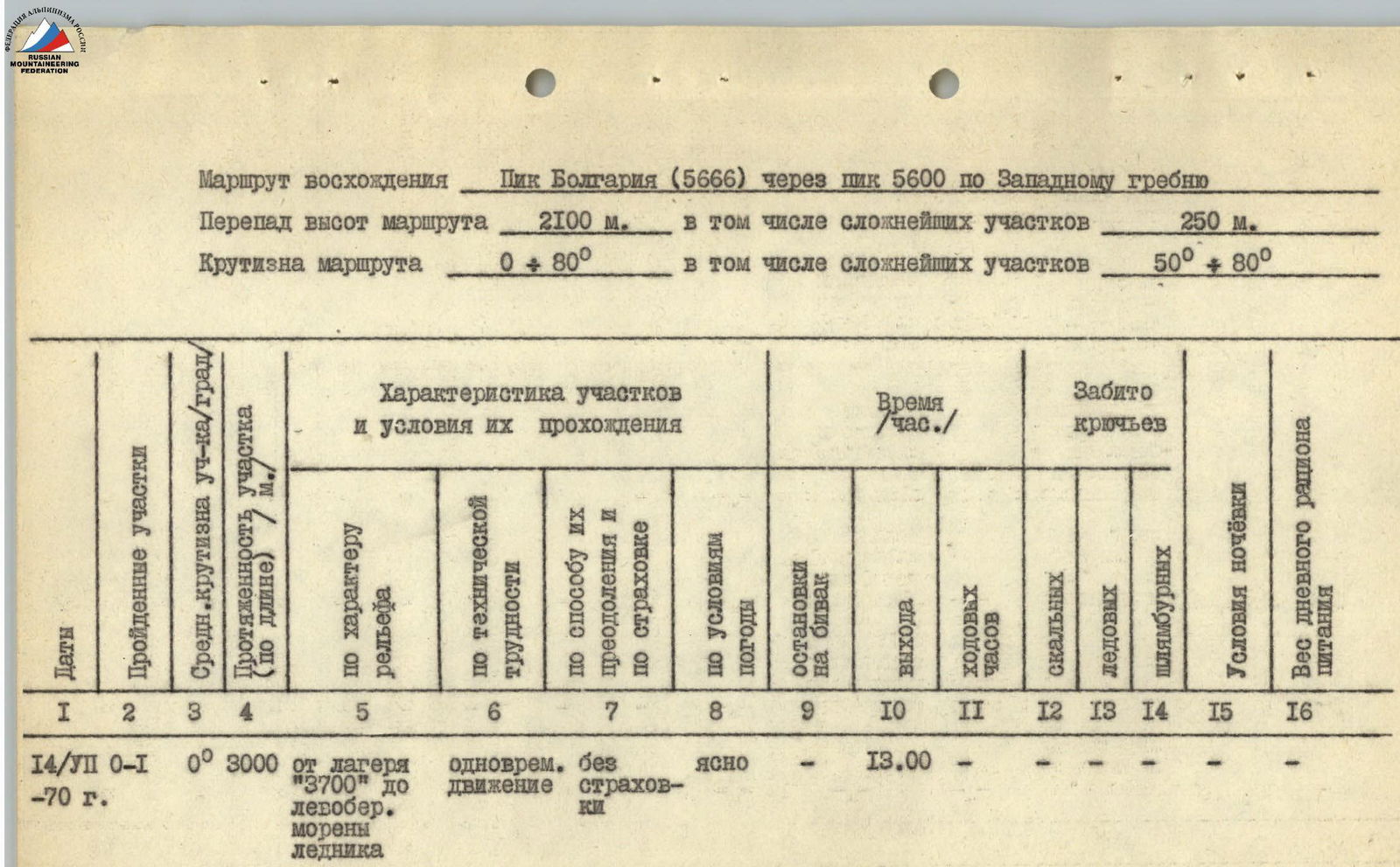
Ascent Route
Peak Bolgariya (5666 m) via Peak 5600 along the Western Ridge
Altitude difference of the route: 2100 m, including the most difficult sections: 250 m.
Steepness of the route: 0°–80°, including the most difficult sections: 50°–80°.
| Dates | Sections traversed | Average steepness of section/° | Length of section (by length) / m | Characteristics of sections and conditions of their passage (by relief) | Characteristics of sections and conditions of their passage (by technical difficulty) | Characteristics of sections and conditions of their passage (by method of overcoming and insurance) | Characteristics of sections and conditions of their passage (by weather conditions) | Time / h (exit) | Time / h (climbing hours) | Pitons driven (rock) | Pitons driven (ice) | Pitons driven (bolted) | Bivouac conditions | Weight of daily ration |
|---|---|---|---|---|---|---|---|---|---|---|---|---|---|---|
| 14/VII | R0–R1 | 0° | 3000 | from camp "3700" to the left-bank moraine of the glacier | simultaneous without insurance | clear | – | 13:00 | – | – | – | – | – | – |
| 14/VII | R1–R2 | 30° | 1500 | moraine, grassy slope | simple free climbing with simultaneous insurance | – | – | – | – | – | – | – | – | – |
| 14/VII | R2–R3 | 50° | 200 | heavily destroyed rocks | – | – | – | – | – | – | – | – | – | – |
| 14/VII | R3–R4 | 20° | 80 | unstable rocks, average steepness of rocks 50° | traverse with occasional insurance through ledges | – | 18:30 | – | 5:30 | – | – | – | area on a rocky ridge | 700 g per person |
| 15/VII | R4–R5 | 20° | 250 | unstable rocky "outcrops" ("grebionka") Steepness of rocks 50° | medium difficulty | traverse with occasional insurance through pitons and ledges | – | 9:00 | – | 2 | – | – | – | – |
| 15/VII | R5–R6 | 60° | 120 | rocky wall — ridge ascent | complex climbing | occasional insurance through pitons and ledges | – | – | – | 4 | – | – | – | – |
| 15/VII | R6–R7 | 60° | 60 | chimney with ice | complex climbing | complex climbing | – | – | – | – | 3 | – | – | |
| 15/VII | R7–R8 | 50° | 60 | rocky wall — ridge ascent | complex climbing | – | – | – | – | 2 | – | – | – | – |
| 15/VII | R8–R9 | 30° | 20 | rocky slab, steepness 80° | complex climbing, traverse | – | – | – | – | 1 | – | – | – | – |
| 15/VII | R9–R10 | 60° | 100 | rocky wall — ridge ascent | complex climbing | – | – | 17:00 | 8:00 | 2 | – | – | area on a ridge (rocky) | 600 g per person |
| 16/VII | R10–R11 | 50° | 60 | snow-ice col with steep ascent | medium difficulty | occasional insurance through ice axe and piton | – | 6:00 | – | 1 | – | – | – | – |
| 16/VII | R11–R12 | 15° | 160 | sharp (60°) snow ridge, with a cornice in the middle | medium difficulty, highly dangerous | occasional insurance through ice axe | – | – | – | – | – | – | – | – |
| 16/VII | R12–R13 | 60° | 10 | unstable summit rocks | medium difficulty | occasional insurance through piton | – | 15:00 | 8:00 | 1 | – | – | snow col with scree, area made of stone slabs | 600 g per person |
| 17/VII | R13–R14 | –20° | 400 | rocky ridge with snow cornices | medium difficulty | simultaneous insurance, occasional through ledges and ice axe | – | 6:00 | – | – | – | – | – | – |
| 17/VII | R14–R15 | 20° | 600 | snow ascent with rocky outcrops (ice on the surface) — summit | medium difficulty | simultaneous insurance, occasional through pitons, ledges, and ice axe | – | – | 4:00 | 4 | 1 | – | – | – |
| 17/VII | R15–R16 | Descent along the ascent path to the upper bivouac | – | – | – | 12:00 | 2:00 | – | – | – | from summit to bivouac | – | ||
| 18/VII | R16–R17 | Descent along the ascent path | – | – | – | 6:00 | 7:00 | – | – | – | – | – | ||
| Total: | 30:00 | 19 | 2 | – | (without approaches) | (during ascent) |