Ascent Log
I. Climb category — high-altitude technical. 2. Climbing area — Pamir, Shakhdarin Range. 3. Peak, its height, and ascent route —
- Peak 5300 m via the right western spur.
- Proposed difficulty category — 3A.
- Route characteristics: height difference — 700 m, average slope — 4°, length of sections: I 60 m; II 80 m; III 50 m; IV 200 m; V 50 m; VI 300 m; VII 40 m; VIII 300 m; IX 200 m; X 400 m.
- Pitons driven: for belay, for creating belay stations. rock — 9 ice — 0 bolt — 0
- Total climbing hours — 6.
- Number of nights — 0.
- Surname, name, patronymic of the leader and participants, their sports qualification:
- Krainov Nikolai Petrovich MS — leader,
- Demin Viktor Ivanovich 1st sports rank,
- Mosin Nikolai Fedotovich 1st sports rank,
- Ochkassov Igor Vasilievich 1st sports rank,
- Raev Vladimir Ivanovich 1st sports rank.
- Team coach — MS Krainov N.P.
II. Date of departure and return — July 8, 1978.
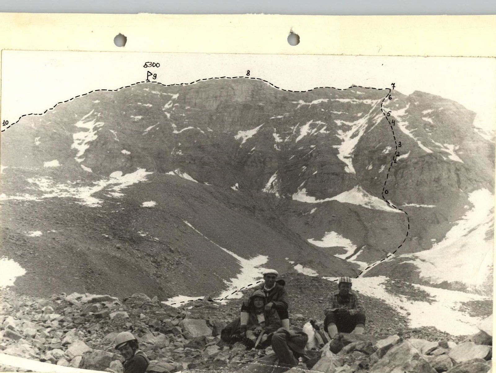
Photo I. Ascent route to Peak 5300 m via the right western spur.
 www.alpfederation.ru↗
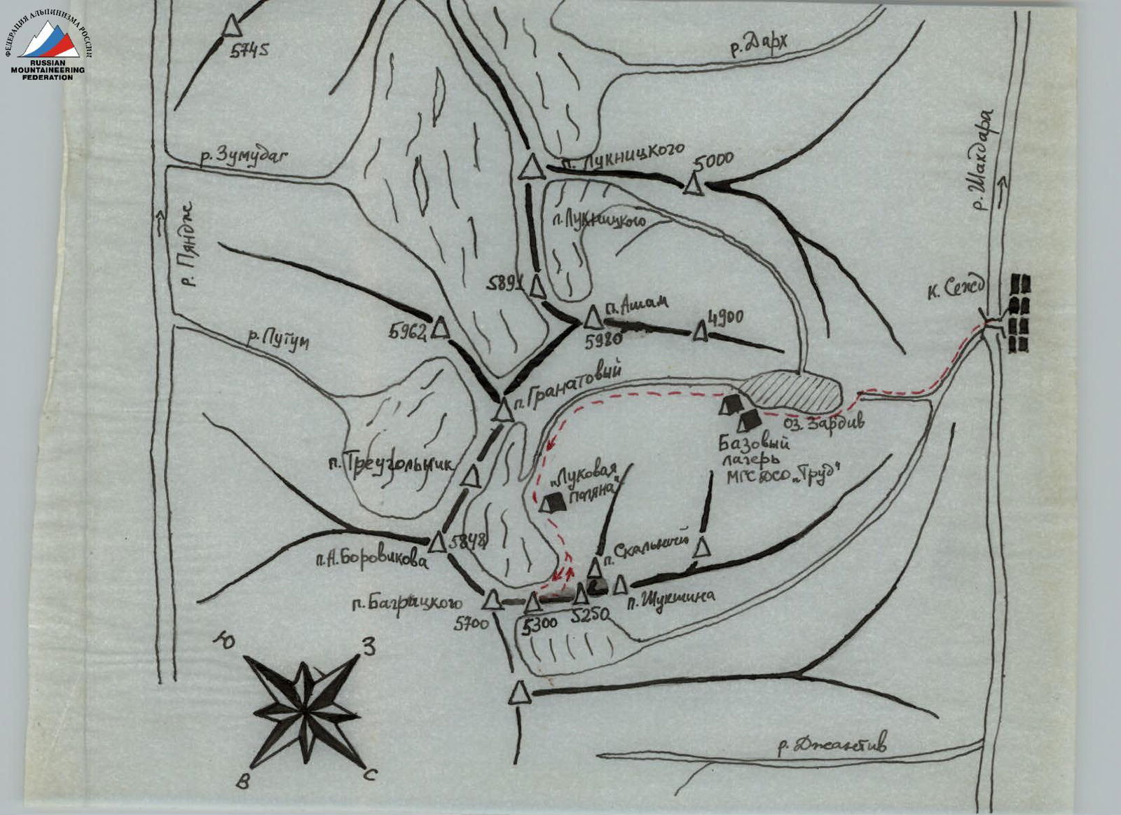
Peak 5300 m is located in the Southwestern Pamir in the northern spurs of the Shakhdarin Range. The base camp of the MGS DSO "Trud" expedition (branch of a/l "Alay") was situated on the eastern shore of Lake Zardiv at the beginning of the Asham gorge at an altitude of 3400 m.
From the base camp, it takes 3–4 hours to reach the campsite on a meadow glade along the right (orographically) bank of the river. From the glade, it takes 2.5–3 hours to approach the route via moraine and scree.
The starting point of the route is the left wall of the right spur, bounded by two snowy couloirs. The spur and ridge are heavily destroyed, so caution and attention are required throughout the route.
- The first two ropes are climbed with piton belay and belay from rock formations (R0–R1).
- Then, two ropes on simple rocks (R1–R2) lead to the second heavily destroyed wall.
- 1.5 ropes up to the wall, with alternating belay from rock formations (R2–R3).
- Then 4–5 ropes on destroyed rock slabs under a series of rock walls 3 to 5 meters high (R4–R5).
- We reach a gentle snowy ridge.
- Up the snowy ridge for 300 m (R5–R6) — to rocks, which are overcome directly with piton belay and belay through rock formations — 1 rope (R6–R7).
- We reach the southern ridge of Peak 5300 m.
Then, left along the ridge on destroyed rocks — 2 ropes. The first two gendarmes are climbed directly or bypassed on the right via a wide shelf — 2 ropes. After the second gendarme, there is a 15–20 meter gap in the ridge. Then up — 3–4 ropes — to the false summit (5280 m) (R7–R8).
From it:
- 4–5 ropes along the rocky ridge to Peak 5300 m.
The descent from the summit is made along the left rocky ridge via route 2B cat. sl. towards the saddle between Peaks 5300 m and 5250 m.
From the saddle:
- via scree — to the moraine;
- then to the campsite on the meadow glade.
The start of the descent from the saddle is prone to rockfall.
Table I. Route characteristics.

| Date | Designation | Average slope (°) | Length (m) | Terrain character | Difficulty | Condition | Weather conditions | Pitons: rock | ice | bolt |
|---|---|---|---|---|---|---|---|---|---|---|
| July 8, 1978 | R0–R1 | 70 | 60 | rocks | 3 | monolithic | Cloudiness, snow, wind. | 7 | – | – |
| R1–R2 | 20 | 80 | rocks | 1 | destroyed | simultaneous movement | ||||
| R2–R3 | 60 | 50 | rocks | 3 | rock formations | |||||
| R3–R4 | 40 | 200 | rocks, slabs | 2 | simultaneous movement | |||||
| R4–R5 | 50 | 50 | rocks | 3 | rock formations | |||||
| R5–R6 | 25 | 300 | snow | 1 | loose | simultaneous movement | ||||
| R6–R7 | 60 | 40 | rocks | 3 | destroyed | 2 | rock formations | |||
| R7–R8 | 30 | 300 | rocks and snow, ridge | 2 | destroyed | simultaneous movement | rock formations | |||
| R8–R9 | 10 | 200 | rocks and snow, ridge | 2 | ||||||
| R9–R10 | 45 | 400 | rocks and snow, ridge | 2 |