
REPORT
ON THE FIRST ASCENT IN THE TECHNICAL CATEGORY
of the expedition team from Kharkov Regional Sports Committee
consisting of: Virchenko Yu.P. — Voronov Yu.N.
Route: p. 4843 (Mramorny) via S.-E. ridge, S.-W. edge
ROUTE PROFILE
Brief description of the approach to the route
p. 4843 (Mramorny) is located in a spur of the Shakhdarin ridge, S.-E. Pamir. This spur branches off the main ridge to the S.-E. towards the Pyanj river valley, and is bounded from the west by the Darshai gorge. The approach to p. 4843 is as follows:
- Up the trail along the Darshai gorge from the village of Darshai, located in the Pyanj river valley, up to the confluence of the Daraiimast river.
- Above the confluence, in the area of the summer camp Kayu, there is a bridge over the Daraydarshai river.
- Cross the bridge over the river and move along the Darshai gorge from the summer camp Kpo on the left side (orographically) of the river upwards, entering the second canyon with a stream.
- Then, up the canyon along the stream on the trail, and then up the steep scree — ascent to the cirque between p. 4843, p. 5913, p. 5071, p. 5634.
Along the right bank of the stream stretches the S.-W. edge of p. 4843. The route begins on the scree between two counterforts:
- The lower counterfort downstream is oriented S.-E. A distinctive feature of this counterfort is the large black streaks descending to the scree.
- Upstream from this counterfort is the second counterfort, oriented south.
At the start of the route, a guiding cairn is built.
ROUTE SCHEME
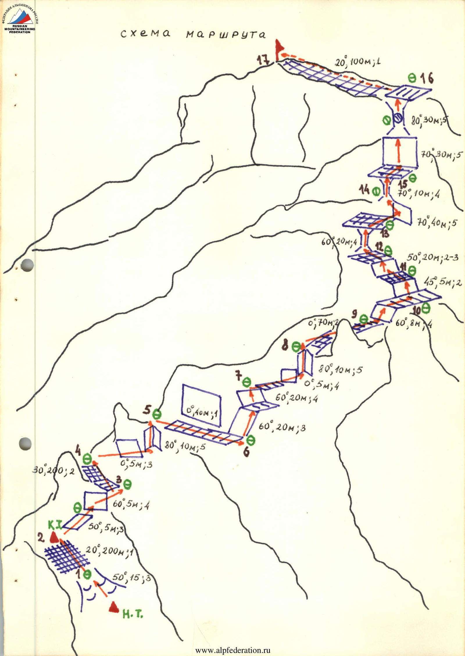
Table of main characteristics of the ascent route
| Date | Character of the section | Number of driven pitons | |||||||
|---|---|---|---|---|---|---|---|---|---|
| designation | average steepness | length | character of relief | difficulty | condition | rock | ice | stoppers | |
| R0–R1 | 50° | 15 m | Rams' foreheads | 3 | monolith | – | – | – | |
| R1–R2 | 20° | 200 m | ridge | 1 | destroyed | simultaneous movement | |||
| R2–R3 | 55° | 10 m | wall | 3,4 | destroyed | Protrusions | – | 1 | |
| R3–R4 | 30° | 200 m | ridge | 2 | destroyed | simultaneous movement | |||
| R4–R5 | 80° | 15 m | Inner corner | 3,5 | monolith | 2 | – | 1 | |
| R5–R6 | traverse | 40 m | Shelf | 1 | – | simultaneous movement | |||
| R6–R7 | 60° | 25 m | wall | 3,4 | monolith | 2 | – | 1 | |
| R7–R8 | 80° | 15 m | Inner corner | 3,5 | monolith | 2 | – | 2 | |
| 7 August 1982 | R8–R9 | traverse | 70 m | ridge | 2 | destroyed | Protrusions | – | – |
| R9–R10 | 60° | 8 m | wall | 4 | destroyed | Protrusions | – | – | |
| R10–R11 | 30° | 55 m | SLOPE | 1,2 | destroyed | simultaneous movement | |||
| R11–R12 | 30° | 20 m | SLOPE | 2,3 | destroyed | Protrusions | – | – | |
| R12–R13 | 60° | 20 m | Chimney | 4 | monolith | – | – | 2 | |
| R13–R14 | 70° | 40 m | Wall | 5 | monolith | 3 | – | 3 | |
| R14–R15 | 70° | 10 m | Chimney | 4 | monolith | 1 | – | – | |
| R15–R16 | 75° | 60 m | Wall, Chimney | 5 | monolith | 5 | – | 1 | |
| R16–R17 | 20° | 100 m | ridge | 1 | destroyed | simultaneous movement |
Explanation of the table
On 7 August 1982, after preliminary reconnaissance and observation, the group left the base camp located in the gorge opposite p. 4843, crossed the Daraydarshai river over the bridge in the area of the summer camp Kapo, ascended the canyon along the S.-W. edge of p. 4843 to the start of the route (4 hours). Further movement of the group along the sections of the route:
Section R0–R1: From the scree between the two counterforts, along the rams' foreheads 15 m, 3 (steepness 50°).
Section R1–R2: Along the scree and destroyed rocks 1 on the left side of the S.-E. counterfort 200 m upwards to the gendarme. At the gendarme, a control cairn.
Section R2–R3: The gendarme is bypassed on the right. First, along the rocks 3, 5 m (steepness 50°), then along the oblique crack 5 m, 4 (steepness 60°), exit to a shelf (1 stopper, and insurance through protrusions).
Section R3–R4: Moving first along the shelf, and then along the destroyed rocks 2, 200 m, approach to the next gendarme on the S.-W. edge.
Section R4–R5: The gendarme is bypassed on the right. Traverse 5 m along the rocks 3, then along the inner corner upwards 10 m (steepness 80°) along the rocks 5, exit to a shelf (2 rock pitons, 1 stopper).
Section R5–R6: Along the shelves to the right along the wall 40 m and descend a bit.
Section R6–R7: Upwards 20 m along the rocks 3 (steepness 60°), exit to a shoulder. From the shoulder to the left-upwards 5 m, 4 (steepness 80°) to a shelf to the wall (1 stopper, 2 rock pitons).
Section R7–R8:
- Along the wall traverse to the right 5 m, 4, approach the inner corner.
- Along the inner corner 10 m, 5 (steepness 80°), exit to the ridge (2 rock pitons, 2 stoppers).
Section R8–R9: Traverse along the ridge 70 m along the destroyed rocks (insurance through protrusions) with an exit to a scree terrace (steepness 40°).
Section R9–R10: Cross the terrace and ascent 8 m (steepness 60°) along the rocks 4 to the next scree terrace.
Section R10–R11: Along the terrace, approach the destroyed rocks 2. Further upwards 5 m — exit to the next terrace. Cross the terrace, moving in the direction of the summit 50 m.
Section R11–R12: Along the destroyed rocks 2, 15 m, and then along the rocks 3, 5 m (insurance through protrusions) — exit to the next terrace.
Section R12–R13: From the terrace along the chimney in the right part of the wall limiting the terrace, 20 m, 4 (steepness 60°), exit to the next terrace (2 stoppers).
Section R13–R14: In the right part of the wall limiting this terrace, there is a crack, which then, expanding, turns into a wide chimney. Approach the chimney, moving along the wall from right to left. 40 m, 5 (steepness 70°).
- 3 rock pitons.
- 3 stoppers.
Section R14–R15: Along the chimney 10 m, 4 (steepness 70°), exit to a terrace before the pre-summit wall with a marble belt (1 rock piton).
Section R15–R16: In the right part of the marble belt, there is a chimney. Moving along the right part of the pre-summit wall:
- 30 m, 5 (steepness 70°), approach the chimney (2 rock pitons, 2 stoppers).
- Then movement along the chimney with a plug (the chimney is strongly expanding at the top): 30 m, 5 (steepness 80°), exit to a shoulder (1 rock piton, 1 stopper, insurance through the plug).
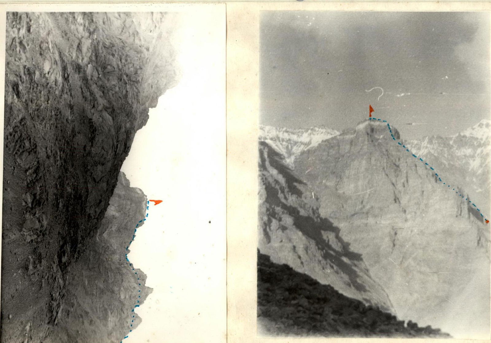
Section R16–R17: From the shoulder 100 m to the left along simple destroyed rocks 100 m, 1 to the summit.
Descent from the summit along the N.-E. ridge towards p. 5634 to a couloir with a stream, and then:
- down along the stream.
- along simple rocks and scree.
- descend into the cirque.
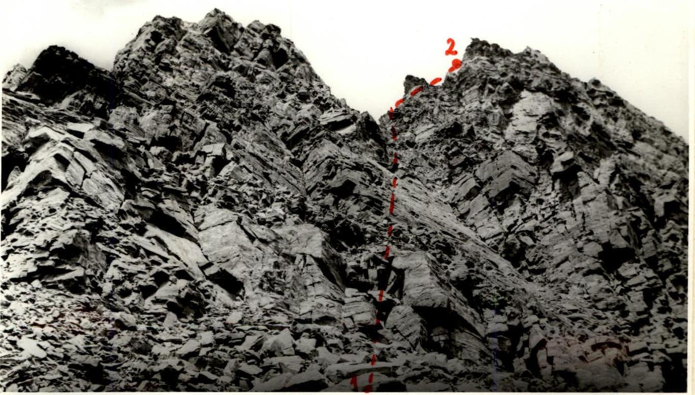
START OF THE ROUTE
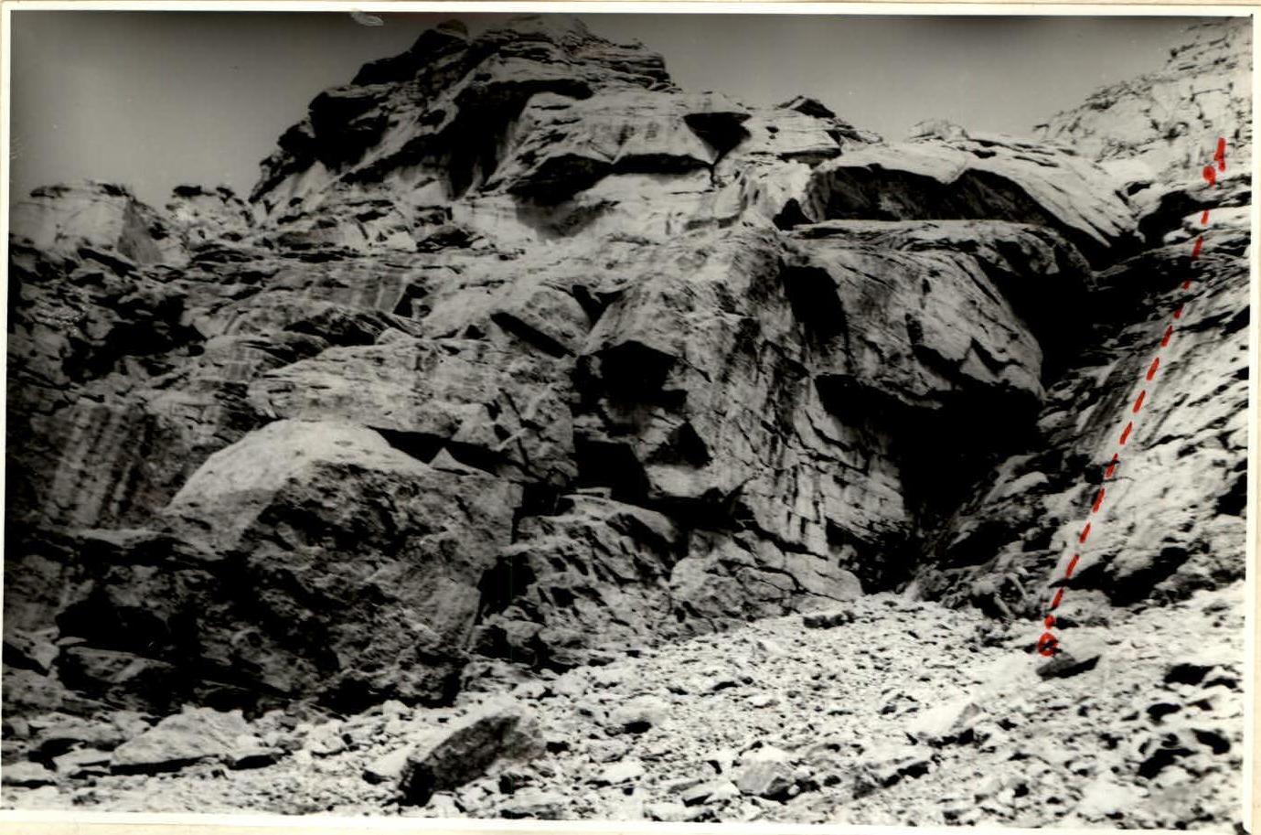
SECTIONS 1–2
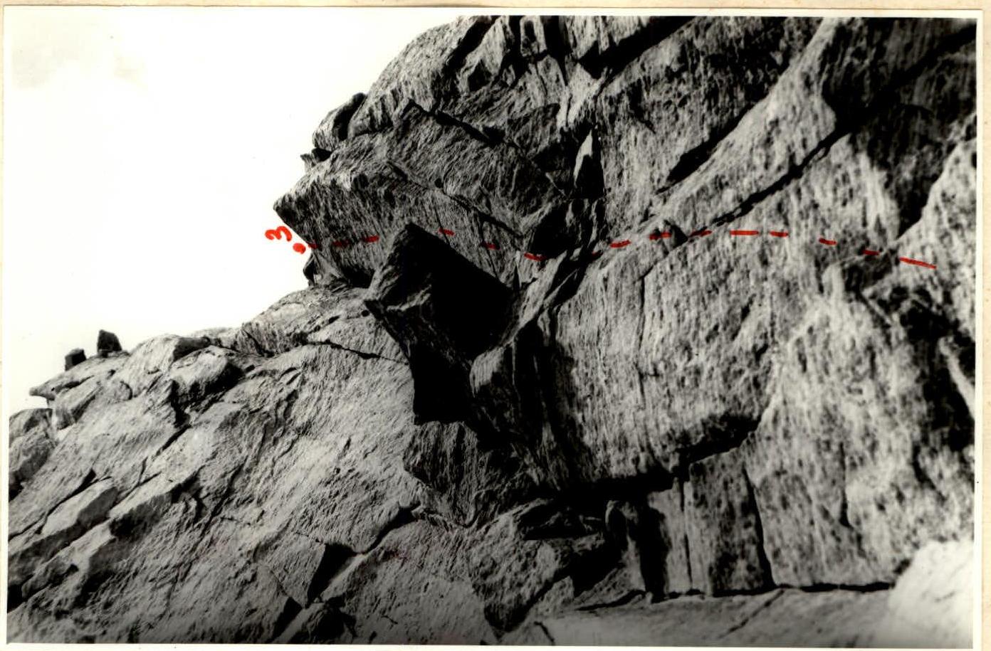
RELIEF OF SECTIONS 2–3
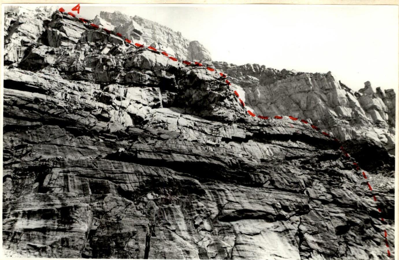
RELIEF OF SECTIONS 3–4
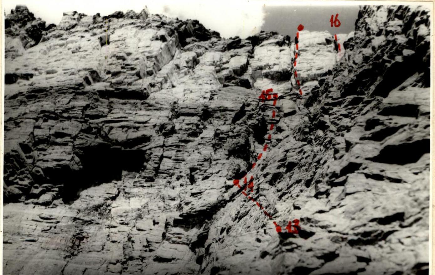
FINAL SECTIONS OF THE ROUTE
Recommendations for the route
The rocks of p. 4843 are heavily destroyed with individual monolithic sections, which is generally characteristic of the Shakhdarin ridge composed of sedimentary rocks. This requires special caution during free climbing. The route passed is technically complex and requires a larger volume of rock work on rocks 4, 5, compared, for example, with routes 4A category of difficulty in the Caucasus and Fann Mountains. Climbers are required to have a high level of rock climbing and psychological preparation. The route is purely rock. There is practically no snow and ice on it. In this regard, it can be recommended that climbers stock up on water in advance. Moreover, on the route, passing along the ridge, mainly oriented to the south, there is a strong heat.
On the other hand, the rocks heat up so much during the day that this allows climbers to take a minimum of camping equipment and warm clothing on the route.
It should be noted that reliable piton placement on the route is very difficult, especially for section R15–R16 (marble belt). On the contrary, the use of protection elements on the route is very convenient and fairly reliable.
In conclusion, we note that by the time the team started the route, the pair was well-acquainted and had experience of jointly passing rock, technically complex routes (4B, 5A category of difficulty) in the Fann Mountains. This allowed them to pass the route at a good pace and reliably cope with its technical complexity.