Report
On the First Ascent in Technical Class
OF THE EXPEDITION TEAM FROM THE KHAARKOV MOUNTAINEERING COMMITTEE
15th pass
Led by Matyukhina L.G.
Route: p. Mionku via the E slope
1982
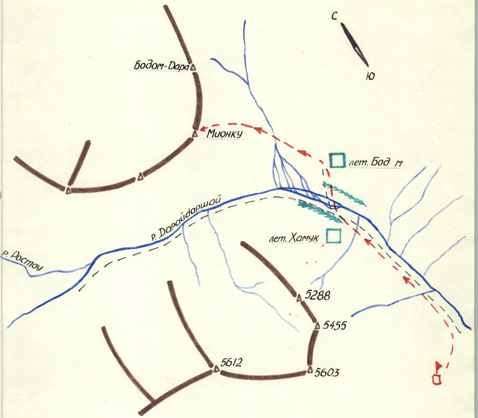
Map of the Area
Brief Description of the Approach to the Route
p. Mionku (local name of the peak) is located in a spur of the Shakhdarian ridge, SW Pamir. To the south, this spur is bounded by the Darshai gorge, and to the east, by the Bodum gorge.
Since the mountains of the Shakhdarian ridge are composed of sedimentary rocks, they are characterized by heavily destroyed rocks and significant scree in the lower parts of the slopes. This typical feature of the Shakhdarian ridge peaks is also evident in p. Mionku.
The height of p. Mionku, approximately 5300 m, is also typical for this part of the Shakhdarian ridge, where peaks are mainly between 5000 m and 6000 m.
The approach to p. Mionku is up the trail along the Darshai gorge from the village of Darshai, located in the Pyandzh river valley, up to the turn towards the Rostou gorge. At this point, the Bodum stream flows into the Daraydarshai river (approximately 25 km from the village of Darshai). On the turn, there are summer pastures on both sides of the Daraydarshai river. Between these summer pastures, there is a fairly convenient ford across the Daraydarshai river.
The summer pasture on the left (orographic) bank of the river is called let. Bodum.
The expedition's base camp was located in the Darshai gorge on a meadow:
- 2 km upstream from the mouth of the Imast river;
- 4 km below the summer pastures.
The group approached the route from let. Bodum. Further movement of the group is described in the Explanation to the table.
Table of Main Characteristics of the Ascent Route
| Date | Character of the Section | Number of Pitons Driven |
|---|---|---|
| average steepness | length | |
| R0–R1 | 40° | 1550 m |
| R1–R2 | 30° | 200 m |
| 10.08.1982 | ||
| R2–R3 | traverse | 100 m |
| R3–R4 | 60° | 8 m |
Explanation to the Table
On August 10, 1982, the group left let. Bodum, crossed the Bodum stream, and approached the base of the E slope of p. Mionku. The group then moved up the E slope in the direction of the SE ridge, then along the SE ridge towards the summit, bypassing a large gendarme on the left.
Section R0–R1. Up the E slope towards the summit across scree, then across destroyed rocks for 1400 m. Further movement towards the SE ridge across destroyed rocks 2 (category of difficulty) for 150 m. Exit onto the SE ridge.
Section R1–R2. Across destroyed rocks 2 (category of difficulty) and scree fields, bypassing the large gendarme on the left, exit onto a saddle connecting the summit with the large gendarme – 200 m.
Section R2–R3. Movement along the saddle towards the summit – 100 m and to the base of a wide chimney.
Section R3–R4. Up the chimney – 8 m, exit onto the summit across rocks 3 (category of difficulty) (2 rock pitons).
Descent via the ascent route.
Approach Diagram