3. Climbing Passport
- Climb category – high-altitude technical.
- Climbing area – Shakhdarin Range, Pamir.
- Peak, its height, and ascent route – peak "Medoviy" (peak 5350) via the Eastern ridge.
- Proposed difficulty category – 3B.
- Route characteristics:
height difference – 1250 m, average steepness – 30°, section lengths – R1–700 m, R2–300 m, R3–25 m, R4–150 m, R5–8 m, R6–200 m, R7–45 m, R8–400 m, R9–350 m.
- Pitons hammered for protection:
rock – 10, ice – 0, bolt – 0.
-
Number of climbing hours – 9.
-
Number of bivouacs – 0.
-
Surname, name, patronymic of the leader and participants, their sports qualification:
-
Sinitsyn A.M. – leader, 2nd sports category,
-
Koprov V.M. – Master of Sports,
-
Degtyarev A.I. – 1st sports category,
-
Rosenfeld B.A. – 1st sports category,
-
Petrov V. – 1st sports category.
-
Team coach – Master of Sports Martynovsky A.L.
-
Date of departure and return – July 4, 1977
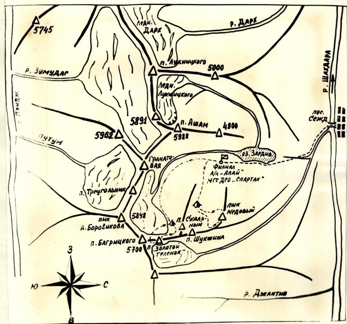
Picture 1. Climbing area map.
- Brief description of the approach to the route.
Peak "Medoviy" is located in the spurs of the Shakhdarin Range in the area of Lake "Zardiv". The first ascent of the route to peak "Medoviy" via the Eastern ridge was made on July 4, 1977 by the team of MGS DSO "Spartak".
From the base camp of the expedition on the shore of Lake "Zardiv" (branch of the "Alay" tourist center) the approach to the route takes about two hours. On the map of the area, this approach is indicated by a dotted line.
The approach includes:
- Ascending along the river (about 40–50 min) to the first tributary on the left (in the direction of travel).
- Steep ascent along this stream with an exit to the cirque formed by the peaks "Medoviy" and "Shukshina" and their spurs.
Here, on the clearing – "Spartak" overnight stays.
2. Route description
From "Spartak" overnight stays, ascend towards peak "Medoviy" to the stream, then up the stream for 300 m. Approaching the black rocky destroyed island, go around it on the right (cairn!). Then ascend by snow to the snowy saddle (1) between peak "V. Shukshina" and peak "Medoviy". The ascent takes 1 hour 20 minutes.
From the saddle, along the Eastern ridge, bypassing the yellow rocks on the left, after 300 m we approach the black destroyed rocky island (2).
Ascend the destroyed rocks on the left to the top of the island (3) and continue ascending along the not steep narrow snowy ridge to the overhanging rock (4).
Further:
- traverse under the rock to the left,
- ascend 7 m up the wet couloir,
- 50 m up and to the right along the destroyed rocks (live rocks!),
- then along the narrow snowy ridge (photo 3).
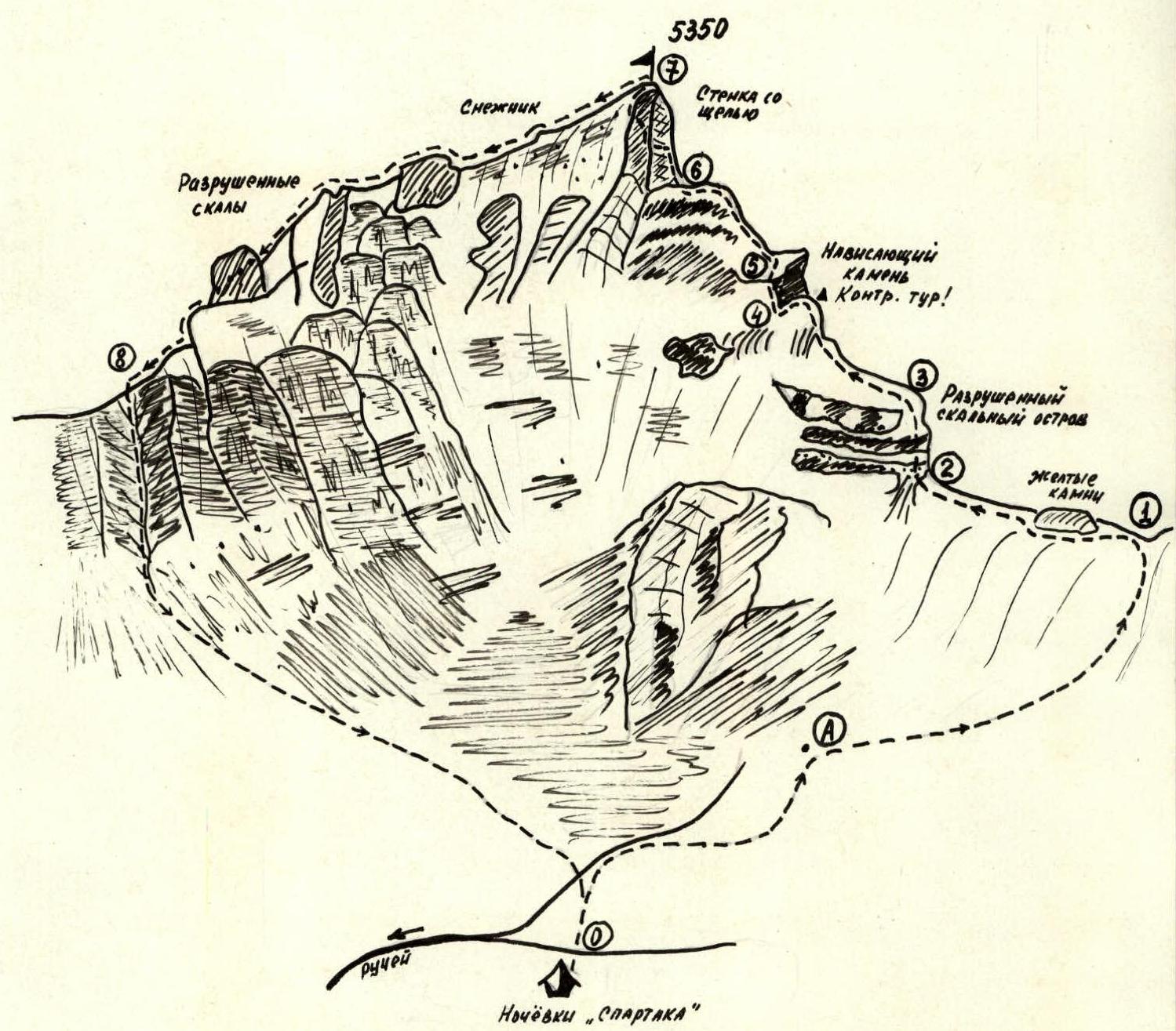
Fig. 1. Route map.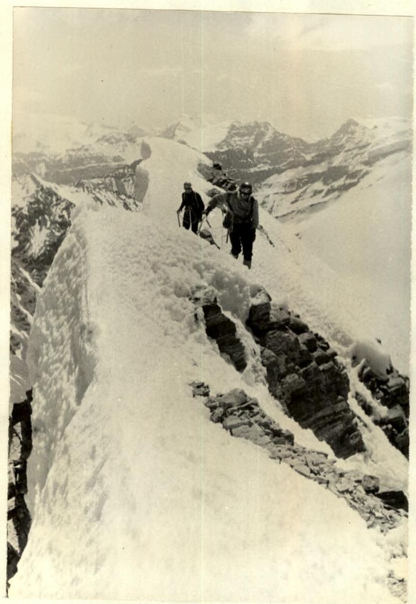
Photo 3. Section (5–6) of the Eastern ridge on the approach to the summit tower. The ridge leads to the edge of the summit tower (6), which is a continuation of the ridge. The total height of the summit tower is more than 40 m. Two variants of passing the tower are possible:
- Ten meters straight up the edge, then left along narrow ledges to the dissected internal angle and further up this angle to exit to the snowy ridge (photo 4). Along the rocks, along the snowy ridge to the summit. One piton was left on this section. When passing the summit tower, all holds must be tested!
- Bypassing the edge on the right, 15 m up the narrow inclined ledge (pitons for protection!) and exit to a horizontal ledge. Ascend 5 m up with a traverse of the inclined ledge to the left to the edge. Along the internal angle and large blocks to the right and up (~20 m) – exit to the summit. On the initial section, special caution is necessary and attention should be paid to the choice of places to hammer pitons due to the strong destruction of the rock! The first option is recommended as safer. The descent from the summit is carried out along the destroyed rocks and snowfields of the Southern ridge. Then descend along the scree couloir and scree to "Spartak" overnight stays.
The first ascent of the route was made in 9 hours. 10 rock pitons were hammered on the route. The difficulty of the route is assessed as 3B category of difficulty. The description is compiled according to the state of the route on July 4, 1977.
Climb leader
(A. Sinitsyn)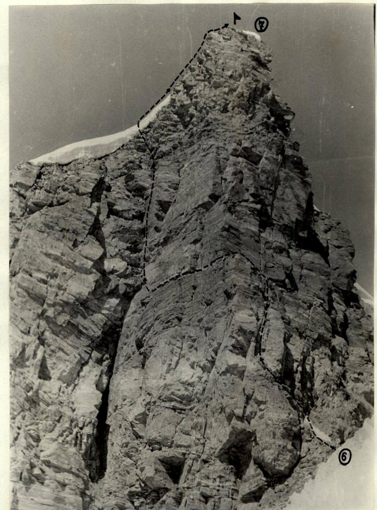
Photo 4. The first variant of passing the summit tower.
Table I. Route characteristics.
| Section characteristics | Section boundaries | Average steepness (°) | Length (m) | Relief characteristics | Difficulty | Condition | Weather conditions | Rock | Ice | Bolt |
|---|---|---|---|---|---|---|---|---|---|---|
| 4.07.77 | 0–1 | 25 | 700 | snow-firn slope | 1 | upper part of the section hard firn | clear, frosty | simultaneous movement | ||
| 1–2 | 10 | 300 | snowy ridge | 1 | soft snow | simultaneous movement | ||||
| 2–3 | 65 | 25 | rocky island | 2 | snow-covered destroyed rocks | 2 | ledges | |||
| 3–4 | 25 | 150 | snowy ridge | 1 | loose snow | simultaneous movement | ||||
| 4–5 | 80 | 8 | couloir | 2–3 | wet couloir with flowstone | 3 | ||||
| 5–6 | 30 | 200 | snowy ridge | 2 | soft snow | ledges, ice axe, simultaneous movement | ||||
| 6–7 | 80 | 45 | rocky wall | 3 | destroyed rocks | 5 | ||||
| 7–8 | 30 | 400 | rocky ridge | 2 | destroyed rocks, snow | ledges, simultaneous movement | ||||
| 8–0 | 40 | 350 | couloir | 2 | steep scree couloir | simultaneous movement |